
(Below are different Going, Goyen, Gowen related sources for those people were in the Virginia, North Carolina, or South Carolina areas in the early 1700’s to early 1800’s)
***************************************************
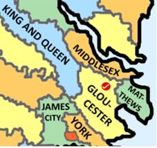
Counties surrounding Gloucester Co, Va
See: https://familysearch.org/wiki/en/Gloucester_County,_Virginia_Genealogy
Gloucester County Virginia History
County seat: Gloucester [1]
Boundary Changes: For animated maps illustrating Virginia county boundary changes, “Rotating Formation Virginia County Boundary Maps” (1617-1995) may be viewed for free at the MapofUS.org website.
Gloucester County Virginia Places/Localities: Neighboring Counties:
Counties to Search in area:
- Virginia – Gloucester County – 1700s to early 1800s
- Virginia – Goochland County – 1700s to early 1800s
- Virginia – Hanover County – 1700s to early 1800s
- Virginia – Henrico County – 1700s to early 1800s
- Virginia – Albemarle County – 1700s to early 1800s
- Virginia – Buckingham County – 1700s to early 1800s
- Virginia – Amelia County – 1700s to early 1800s
- Virginia – Powhatan County – 1700s to early 1800s
- Virginia – Chesterfield County – 1700s to early 1800s
- Virginia – Powhatan County – 1700s to early 1800s
- Virginia – Louisa County – 1700s to early 1800s
- Virginia – New Kent County – 1700s to early 1800s
- Virginia – Charles City County – 1700s to early 1800s
- Virginia – York County – 1600s to early 1800s
- Virginia – James City County – 1700s to early 1800s
- Virginia – Westmoreland County – 1700s to early 1800s
- Virginia – Stafford County – 1700s to early 1800s
- Virginia – Surry County – 1700s to early 1800s
- Virginia – Fairfax County – 1700s to early 1800s
- Virginia – Prince William County – 1700s to early 1800s
- Virginia – Amherst County – 1700s to early 1800s
- Virginia – Appomattox County – 1700s to early 1800s
- Virginia – Campbell County – 1700s to early 1800s
- Virginia – Caroline County – 1700s to early 1800s
- Virginia – Charlotte County – 1700s to early 1800s
- Virginia – Nansemond County – 1700s to early 1800s
- Virginia – Shenandoah County – 1700s to early 1800s
Goings with Pages on this site connected to this county:
- Christopher Gowen Sr., b. abt 1649 m. to Ann lived in Gloucester Co, Va and Nansemond Co, Va.
- Michael Gowen b. abt 1679, of Gloucester Co, Va., son of Christoper Gowen Sr and Ann
- Daniel Gowen b. abt 1655 of Gloucester Co, Va (land patents in 1679 and 1698)
- Edward Gowen b. abt 1680, of Gloucester Co, Va (1704 quitrent)
- James Gowen b. abt 1725, fathered Sarah Gowen Jan 16, 1759 in Gloucester Co, Va; James Going on 1770 tithe list in Gloucester Co, Va; In 1786 – James Gowen signed a Petition asking Incorporation Act not be repealed; James Gowen was listed as the head of a household in 1810 (45 yrs of age or older) in Gloucester Co, Va.
- Sarah Gowen was born to James Gowen on 1759 January 16, in Gloucester Co, Va
- Lucy Gowing b. abt 1725-33, marries William Jarvice in 1750 in Gloucester Co, Va
- Joseph Going b. abt 1740 m Priscilla – child Ann Going born June 20, 1762, in Gloucester Co, Va
- Ann Going is born June 20, 1762, Parents: Joseph Going & Priscilla in Gloucester Co, Va
- Mary Gowen born abt 1735-1745 with 200 acres appears on the 1770 tax list of Gloucester Co, Va
- Sarah Gowen b. abt 1731-39, marries Panranparabo Boswell February 1, 1756 in Gloucester Co, Va
- Joyce Gowing b. abt 1731-39, marries Thomas Willison 1756 Dec 18 in Gloucester Co, Va
- Priscilla Gowing b. abt 1742-1750, marries William Wright on Aug 7, 1767 in Gloucester Co, Va
- Frances Gowen born between 1766 to 1784 was listed as the head of a household in 1810 (26-44 yrs old) in Gloucester Co, Va
Gloucester County, Virginia – INFO:
1678 – Christopher Gowen, is married, wife’s name Anne.
Michael Gowen, (G9/1.4), son of Christopher Gowen (G10/1.1) and Anne Gowen, was born in January 1679, according to Abingdon Parish Register, Gloucester Co, page 2. Of this individual nothing more is known.
1679 January – Michael Gowen, son of Christopher Gowen and Anne Gowen, was born
1679 January – Michael Gowen is born in January 1679, according to “Abingdon Parish, Gloucester County, Virginia Register, 1678-1761,” page 275. Glaucester Co, Va
1679 May 1 – Virginia Land Patents – bk 6, p. 679 – … and grant unto Daniel Gohon 100 acres of land in Kingston Parish in Gloucester County … on the western side of a small creek on the NW side of the sd Gohon’s plantation running thence by Mr Henry Preston’s line of marked trees … the sd land being due for the importation of 2 persons … (People transported): Mary Hare, Ralph Rand.
https://www.familysearch.org/ark:/61903/3:1:3Q9M-CSLZ-PS2H-J?i=680&cat=584564
1698 April 26th – Virginia Land Patents – bk 9, p. 147 – … grant unto Daniel Gowin 52 acres of land in Gloucester County beginning at a marked corner red oake of Mr Henry Preston’s land and running thence along said Preston’s line north … along Mr Ambross Dudley’s line … to a large corner pine of the said Dudley’s and Capt Ransons land … to the line of Thoman Rilands land then along the said Rylands line to the beginning … for the transportation of one person into this Colony …
https://www.familysearch.org/ark:/61903/3:1:3Q9M-C37S-JSTT-K?i=171&cat=584564
1702 July 4 – “Michael Gowin” and “Phillip Gowin” were serving in the militia July 4, 1702 in nearby New Kent County. They were serving under Col. John Lightfoot.
1704 Edward Gowing is listed on Quit Rents of Virginia – on 100 acres, Kingston, Gloucester Co, Va
http://interactive.ancestry.com/48421/QuitRentsVA-005295-34?backurl=http%3a%2f%2fsearch.ancestry.com%2fsearch%2fdb.aspx%3fdbid%3d48421%26path%3d&ssrc=&backlabel=ReturnBrowsing#?imageId=QuitRentsVA-005298-37
http://interactive.ancestry.com/48646/VATaxRecords-005345-532/437998?backurl=&ssrc=&backlabel=ReturnSearchResults&rc=472,686,642,728#?imageId=VATaxRecords-005345-532
http://ourberryfamily.com/berry/pictures/1704taxedwardgowinggloucestercova.jpg
http://www.ancestraltrackers.net/va/resources/english-duplicates-lost-virginia-records.pdf (p. 143).
1747 Jan 28 – John Machin recd 606a in 1747, sold to John Robinson in 1755 Sept 10. Land along Gowen’s line, John Carry’s line, and Dudley’s line. (also listed as Sept 10, 1754).
Gloucester Co, Va.
http://interactive.ancestry.com/6131/VGS_1994_01_01_0089/521176153?backurl=http%3a%2f%2fsearch.ancestry.com%2fcgi-bin%2fsse.dll%3fdb%3dvgs%26gss%3dsfs28_ms_r_db%26new%3d1%26rank%3d1%26gsln%3dGowen%26gsln_x%3d0%26MSAV%3d1%26uidh%3dm37&ssrc=&backlabel=ReturnSearchResults&rc=1829,1393,1972,1431
http://interactive.ancestry.com/49309/FLHG_RecsColGloucesterCnty-0156?backurl=http%3a%2f%2fsearch.ancestry.com%2fsearch%2fdb.aspx%3fdbid%3d49309%26path%3d&ssrc=&backlabel=ReturnBrowsing#?imageId=FLHG_RecsColGloucesterCnty-0078
1750 Jan 22 – Lucy Gowing marries William Jarvice, by Rev Richard Locke. Kingston Parish Register, Gloucester Co, Va.
http://interactive.ancestry.com/49215/FLHG_KingstonParishRegister-0168?backurl=http%3a%2f%2fsearch.ancestry.com%2fsearch%2fdb.aspx%3fdbid%3d49215%26path%3d&ssrc=&backlabel=ReturnBrowsing#?imageId=FLHG_KingstonParishRegister-0023
1755 in Kingston Parrish w John Machin next to Henry Preston, Cary’s line, Dudley’s line, and Gowen’s line
http://interactive.ancestry.com/6131/VGS_1994_01_01_0089/521176153?backurl=http%3a%2f%2fsearch.ancestry.com%2fcgi-bin%2fsse.dll%3fdb%3dvgs%26gss%3dsfs28_ms_db%26new%3d1%26rank%3d1%26msT%3d1%26gsln%3dGowen%26gsln_x%3d0%26MSAV%3d0%26uidh%3dm37&ssrc=&backlabel=ReturnSearchResults&rc=1829,1393,1972,1431
1756 February 1- Sarah Gowen, married Panranparabo Boswell February 1, 1756, according to “Kingston Parish Register of Gloucester and Matthews Counties, Virginia, 1749-1827.” page 227 compiled by Emma R. Matheny and Helen K. Yates. Gloucester Co, Va.
http://interactive.ancestry.com/49215/FLHG_KingstonParishRegister-0168?backurl=http%3a%2f%2fsearch.ancestry.com%2fsearch%2fdb.aspx%3fdbid%3d49215%26path%3d&ssrc=&backlabel=ReturnBrowsing#?imageId=FLHG_KingstonParishRegister-0013
1756 Dec 18 – Joyce Gowing marries Thomas Willis. Kingston Parish Register, Gloucester Co, Va
http://interactive.ancestry.com/49215/FLHG_KingstonParishRegister-0168?backurl=http%3a%2f%2fsearch.ancestry.com%2fsearch%2fdb.aspx%3fdbid%3d49215%26path%3d&ssrc=&backlabel=ReturnBrowsing#?imageId=FLHG_KingstonParishRegister-0032
1759 January 16 – Sarah Gowen was born to James Gowen. According to “Abingdon Parish, Gloucester County Register. 1678-1761,” page 175. Gloucester Co, Va.
1762 June 20 – Ann Going – born, Father: Joseph Going, Mom: Priscilla
Christened: Kingston Parish, – Baptized on July 4, 1762, in Gloucester Co, Va.
https://familysearch.org/ark:/61903/1:1:VRRC-YH6
http://interactive.ancestry.com/49215/FLHG_KingstonParishRegister-0168?backurl=http%3a%2f%2fsearch.ancestry.com%2fsearch%2fdb.aspx%3fdbid%3d49215%26path%3d&ssrc=&backlabel=ReturnBrowsing#?imageId=FLHG_KingstonParishRegister-0067
1767 Aug 7 – Priscilla Gowing marries William Wright. Kingston Parish Register, Gloucester Co, Va
http://interactive.ancestry.com/49215/FLHG_KingstonParishRegister-0168?backurl=http%3a%2f%2fsearch.ancestry.com%2fsearch%2fdb.aspx%3fdbid%3d49215%26path%3d&ssrc=&backlabel=ReturnBrowsing#?imageId=FLHG_KingstonParishRegister-0033
1770- James Going on Tho Goalder’s roll, Mary Gowen with 200 acres appeared on the 1770 tax list of Gloucester County, according to “Records of Colonial Gloucester County.”, Va.
http://interactive.ancestry.com/49309/FLHG_RecsColGloucesterCnty-0156?backurl=http%3a%2f%2fsearch.ancestry.com%2fsearch%2fdb.aspx%3fdbid%3d49309%26path%3d&ssrc=&backlabel=ReturnBrowsing#?imageId=FLHG_RecsColGloucesterCnty-0125
In 1786 – James Gowen signed a Petition asking Incorporation Act not be repealed. Kingston Parrish. Gloucester Co, Va
http://interactive.ancestry.com/6131/VGS_1991_01_01_0265/519603465?backurl=http%3a%2f%2fsearch.ancestry.com%2fcgi-bin%2fsse.dll%3fdb%3dvgs%26gss%3dsfs28_ms_r_db%26new%3d1%26rank%3d1%26gsln%3dGowen%26gsln_x%3d0%26MSAV%3d1%26uidh%3dm37&ssrc=&backlabel=ReturnSearchResults&rc=108,1010,220,1043;263,1172,373,1205#?imageId=VGS_1991_01_01_0265
1786 Kingston Parrish petition signed by James Gowin. Gloucester Co, Va
http://interactive.ancestry.com/6131/VGS_1991_01_01_0265/519603465?backurl=http%3a%2f%2fsearch.ancestry.com%2fcgi-bin%2fsse.dll%3fdb%3dvgs%26gss%3dsfs28_ms_db%26new%3d1%26rank%3d1%26msT%3d1%26gsln%3dGowen%26gsln_x%3d0%26MSAV%3d0%26uidh%3dm37&ssrc=&backlabel=ReturnSearchResults&rc=108,1010,220,1043;263,1172,373,1205#?imageId=VGS_1991_01_01_0265
Possible related info:
1642 Hugh Gwyn receives 1700 acres neare the mouth of Pyankatanke river. Gloucester Co, Va.
http://image.lva.virginia.gov/cgi-bin/drawer?retrieve_image=LONN&dir=/LONN/LO-1/001/001&image_number=0872&offset=%2B7&name=Patents+No.1++1623-1643+VOL.1%262&dbl_pgs=no&round=
“Richard Barnhouse, Jr. appears as a resident of Gloucester County, Virginia in 1653, according to “Early Virginia Immigrants” by George Cabel Greer. “Capt. Richard Barnhouse” and “Richard Barnhouse, Gentleman” were residents of James City County, Virginia in 1656. Anne Stafford Barnhouse identifies herself as a widow August 25, 1655, suggesting that she was married to Richard Barnhouse, Sr.
Gloucester Co, Va Grants – possible hints and connections:
1637 Nov 23 – Land grant – Richard Preston, grantee.
1637 – 1123, Location: County location not given.
Description: 100 acres lying upon the uppermost end of Thomas Jordans great Indian field… for the importation of two servants called Michael Vinbles and Walter Brute (sp?).
Source: Land Office Patents No. 1, 1623-1643 (v.1 & 2), p. 502 (Reel 1).
https://www.familysearch.org/ark:/61903/3:1:3Q9M-C37S-3SPY-1?i=507&cat=584564
1639 Jan 6 – Land grant – Richard Preston, grantee.
1639 – 0106, Location: Upper Norfolk County.
Description: 500 acres in the upper Norfolke and lying upon the miles end of the lands of Thomas Jorden and Richard Young, on New Town Haven River … being the head of a small greeke or Gutt belonging to New Towne Haven River … for the transportation of 5 servants into this Colony whose names are in the records mentioned under this pattent…
William Barham, Richard Pettibone, Joane Carraway, Michael Morphew, Edward Ratcliffe.
Source: Land Office Patents No. 1, 1623-1643 (v.1 & 2), p. 767 (Reel 1).
https://www.familysearch.org/ark:/61903/3:1:3Q9M-C37S-3SG4-L?i=772&cat=584564
1639 May 11 – Richard Preston, grantee.
1639 – 0511, Location: Upper Norfolk County.
Description: 150 acres in the Upper County of New Norfolke about four miles up Chuckatuck River, a mile from the northerly side of the river, upon the westerly side of a small running Creeke known by the name of the Jordinn Suares(sp?) butting southerly for the roadeth upon the land of Samuell Owsly and William Jirlards(sp?) … for the transportation of three persons into this Colony whose names are in the records mentioned under this pattent ..
Mi? Colison, Lewis Long, Nathan? Jones.
Source: Land Office Patents No. 1, 1623-1643 (v.1 & 2), p. 645 (Reel 1).
https://www.familysearch.org/ark:/61903/3:1:3Q9M-C37S-3SKF-V?i=650&cat=584564
1646 Dec 18 – Land grant – Richard Preston, grantee.
1646 – 1218, Location: Upper Norfolk County.
Description: 500 acres upon the miles end of the land of Thomas Jordan and Richard Young, on New Town Haven River … (land still due from prior patents in 1637 and 1639) … for the transportation of 5 persons into the Colony whose names are in the records mentioned under this patent …
Source: Land Office Patents No. 2, 1643-1651, p. 63 (Reel 2).
https://www.familysearch.org/ark:/61903/3:1:3Q9M-CSLZ-BQ46-6?i=98&cat=584564
1651 Oct 10 – Land grant. John King, grantee.
1651 – 1010, Location: Gloucester County.
Description: 200 acres upon the north west side of Poropotank Creek and upon the N. Wt. side and towards the head of Bennetts Creek … upon the land of Thomas Litechmans and John Bennett … for the transportation of 4 persons into the Colony …
Richard Kelley, Wolt Mander, Francis Williams, James Town
Source: Land Office Patents No. 2, 1643-1651, p. 345 (Reel 2).
https://www.familysearch.org/ark:/61903/3:1:3Q9M-CSLZ-BQ4W-Q?i=369&cat=584564
1652 May 6 – Land grant. Peter Ranson, grantee.
1652 – 0506. Location: County location not given.
Description: 300 acres butting east upon the Broad Creeke, south upon Marke Johnsons Land, north upon Thomas Watts land, west into the woods … for the transportation of 6 persons into the Colony …
Source: Land Office Patents No. 3, 1652-1655, p. 202 (Reel 2).
https://www.familysearch.org/ark:/61903/3:1:3Q9M-CSLZ-BQH2-W?i=625&cat=584564
1652 July 3 – Land grant. Richard Dudley, grantee.
1652 – 0703. Location: County location not given.
Description: 200 acres on the eastward side of the north river in Mockjack Bay: Beg.g &c. on the river side of Mr. Curtis’s land, near the Black Water Creekes mouth … for the transportation of 4 persons …
William Marksby, William Mash, Fra: Halliard, Mary Andrews.
Source: Land Office Patents No. 3, 1652-1655, p. 94 (Reel 2).
https://www.familysearch.org/ark:/61903/3:1:3Q9M-CSLZ-BQHY-C?i=517&cat=584564
1652 Aug 2 Land grant. Thomas Preston, grantee.
1652 – 0802. Location: County location not given.
Description: grant unto Thomas Preston the son of Thomas Preston decd 500 acres on the West side of the eastermost river, in Mockjack Bay: beg.g at a marked tree on the south side of a creeke … for the transportation of 10 persons into the Colony …
William Senter, James Laird, Thomas Fairwell, A negro child, Henry Barrow, John Groves, John Barber, Peter Farlin (or Farbin), Richard Neale, Walter True – By assignment from Thomas Conniers.
Source: Land Office Patents No. 3, 1652-1655, p. 204 (Reel 2).
https://www.familysearch.org/ark:/61903/3:1:3Q9M-CSLZ-BQHD-3?i=627&cat=584564
1652 Sept 2 – Land grant. Peter Ranson, grantee.
1652 – 0902. Location: County location not given.
Description: 1100 acres on the eastward side of the North River in Mockjack Bay, beg.g &c. by a small creeke that divides this Land from the Land of Richard Dudley … on a creeke called Isle of Wight Creeke … for the transportation of 22 persons into the Colony …
Source: Land Office Patents No. 3, 1652-1655, p. 108 (Reel 2).
https://www.familysearch.org/ark:/61903/3:1:3Q9M-CSLZ-BQHK-4?i=531&cat=584564
1652 Sept 20 Land grant. William Dudley, grantee.
1652 – 0920. Location: County location not given.
Description: 400 acres on the westerne side of the north river in Mockjack Bay: beg.g at a marked tree opposite to Five Pine Island … to the head of Ginger Creeke … for the transporation of 8 persons into this Colony …
This patent by reason of a mistake is surrendered and relinquished and one for 350 acres recorded in the name of the aforesaid Dudley dated as this along written …
Source: Land Office Patents No. 3, 1652-1655, p. 198 (Reel 2).
https://www.familysearch.org/ark:/61903/3:1:3Q9M-CSLZ-BQHD-M?i=621&cat=584564
1652 Sept 28 – Land grant. Thomas Preston, Jr. grantee.
1652 – 0928. Location: County location not given.
Description: 200 acres on the westward side of the easter most river in Mockjack bay, beg.g &c. at the head of Chesnut Creeke … to a marked tree of Thomas Todd land … to the Bay … for the transportation of 4 persons into this Colony …
Henry Subrill, Richard Davis, Sabrina Davis, Thomas Conyer, … by assignment from Thomas Conyer.
Source: Land Office Patents No. 3, 1652-1655, p. 128 (Reel 2).
https://www.familysearch.org/ark:/61903/3:1:3Q9M-CSLZ-BQH6-Q?i=551&cat=584564
1652 Nov 16 – Land grant. William Thomas, grantee.
1652 – 1116. Location: County location not given.
Description: 700 acres lying on the north east side of Mockjack Bay: beg.g at a certain markt trees of Mr. Ransons … to markt trees of Thomas Preston decd and by the said Preston markt tree southwest by south … for the transportation of 14 persons …
Christopher Doyle, Thomas Bayley, Joane Middleton, John Rawlins, John Nash, John Barlow, William Christopher.
Source: Land Office Patents No. 3, 1652-1655, p. 146 (Reel 2).
https://www.familysearch.org/ark:/61903/3:1:3Q9M-CSLZ-BQH5-S?i=569&cat=584564
1653 Apr 27 Land grant. Richard Barnhouse, Jr. grantee.
1653 – 0427. Location: Gloucester County.
Description: 200 acres on the south side of Mattapony River, two miles above the Indian Ferry … bounded West Northwest upon the land of Capt Robert Abrahall … upon the land of Mr William Wyatt … upon Mattapony River … for the transportation of 4 persons into this Colony …
William Allen, Robert Yates, Mary Collier, John Greensham
Source: Land Office Patents No. 3, 1652-1655, p. 193 (Reel 2).
https://www.familysearch.org/ark:/61903/3:1:3Q9M-CSLZ-BQHW-X?i=616&cat=584564
1653 June 9 – Peter Ranson, grantee. Location: County location not given.
Description: 1100 acres on the North River of Mobjack Bay: beg.g att a creeke called ye Isle of Wight Creek … from thence to … land now in possession of Richard Dudly … the said land was formerly granted unto Edmond Dawber by patent and adjudged deserted … said order granted unto the said Peter Ranson … for transportation of 22 persons into this Colony
Source: Land Office Patents No. 3, 1652-1655, p. 22 (Reel 2).
Part of the index to the recorded copies of patents for land issued by the Secretary of the Colony serving as the colonial Land Office. The collection is housed in the Archives at the Library of Virginia.
https://www.familysearch.org/ark:/61903/3:1:3Q9M-CSLZ-BQCM-X?i=445&cat=584564
1653 Sept 11 – Land grant. Thomas Todd, grantee.
1653 – 0911. Location: County location not given.
Description: 600 acres on the westward side of the eastermost river in Mockjack Bay, beginning at Chesnutt Creek … joining to William Holders land … for the transportation of 12 persons into this Colony …
Thomas Viggins(sp?), John Martin, John Blake, John Thorne(sp?) Sanders Mandrose, John Neale, Mary Maddox, James Mackay.
Source: Land Office Patents No. 3, 1652-1655, p. 70 (Reel 2).
https://www.familysearch.org/ark:/61903/3:1:3Q9M-CSLZ-BQHR-4?i=493&cat=584564
1654 June 7 Land grant. Thomas Preston & Henry Preston grantees.
1654 – 0607. Location: County location not given.
Description: 650 acres on the west side of the eastermost river in Mockjack Bay … : part of this land, 500 acres surrendered into the office 150 acres and residue by and for transportation of 3 persons into this Colony … by virtue of a pattent: grantd. to sd. Tho. Preston dated 2nd of Augt. 1652, see pa: 204.
Source: Land Office Patents No. 3, 1652-1655, p. 270 (Reel 2).
https://www.familysearch.org/ark:/61903/3:1:3Q9M-CSLZ-BQH7-K?i=689&cat=584564
1654 Sept 20 Land grant. Col. Humphry Higgenson Esqr. and his son Thomas Higgenson grantee.
1654 – 0920. Location: Gloucester County.
Description: unto Col Humphry Higgenson Esqr one of the Councell of State for this Colony and Thomas Higgenson sonn of the said Col. Higgenson 800 acres upon the south side of Pyanketanck River; beg. at the mouth of a small creek which divideth this land from the land of Col. Hugh Gwin now in the possession of Wm. Armstead … to another creek commonly known by the name of Pranketanck Creek … 500 acres hereof by assignment of Col Ludlow out of a pattent of 2000 acres granted unto him and 300 acres the residue by and for the transportation of 6 persons into this Colony …
Source: Land Office Patents No. 3, 1652-1655, p. 304 (Reel 2).
https://www.familysearch.org/ark:/61903/3:1:3Q9M-CSLZ-BQH3-D?i=723&cat=584564
1655 Mar 17 Land grant. Richard Barnhouse, Jr. grantee.
1655 – 0317. Location: Gloucester County.
Description: 200 acres upon the south east side of Mattapony River, two miles above the Indian Ferry … bounded … upon the lands of Lt. Col. Robert Ahalls … along Apostiques Creek … upon the lands of Mr William Wyatt …
Source: Land Office Patents No. 4, 1655-1664, p. 33 (Reel 4).
https://www.familysearch.org/ark:/61903/3:1:3Q9M-C379-1SNG-7?i=36&cat=584564
1657 Mar 11 Land grant. Col. Hugh Gwin, grantee.
1657 – 0311. Location: Gloucester County.
Description: 165 acres upon the So. Wt. side of a tract of land formerly surveyed for Edward Clersifull upon Milford Haven Creek … beginning upon the head line of the aforesaid Clersifull … for the transportation of 4 persons …
Source: Land Office Patents No. 4, 1655-1664, p. 236 (Reel 4).
https://www.familysearch.org/ark:/61903/3:1:3Q9M-C379-1SVJ-S?i=239&cat=584564
1659 Sept 24 Land grant. Richard Dudley, grantee.
1659 – 0924. Location: Gloucester County.
Description: 639 acres lying on the eastward side of the north river, in Mockjack Bay. Beginning at a small creeks mouth that lies within Black Waters Creeks mouth called Pine Point Creek … along marked trees which parts this land and the land of Mr Peter Ranson … due unto the said Dudly … 140 acres part thereof formerly greanted to Majr Thomas Curtis by patent dated in the year 1642 and by him assigned to the said Dudley, and 200 acres another part thereof being formerly granted unto him the said Mr Dudley by patent bearing date the 3d of July 1652 & the residue being 299 acres by and for the transportation of 6 persons into this Colony.
Source: Land Office Patents No. 4, 1655-1664, p. 377 (Reel 4).
https://www.familysearch.org/ark:/61903/3:1:3Q9M-C379-1SJT-5?i=381&cat=584564
1661 Nov 20 Land grant. Hugh Gwynn, grantee.
1661 – 1120. Location: Gloucester County.
Description: 2000 acres. 1700 acres part hereof near the mouth of Peanketank River and 200 acres of marsh beginning at a Sandy point that buts upon Cheesepeake bay … up a bay called Millford Haven … bounded by a Great Bay called Sting Graye Bay … from the mouth of Peanketank River where his other Divident lies …. at the Sandy Point at the west and his Island … runs parallel unto Rappahanneck Bay …. unto Chesapake Bay … and 300 acres the residue upon the southwest side of a tract of land called Gwynns Island being the surplussage of the said Island bounding … upon the … opposite to the mouth of Peanketank River … south upon Deep Creek … 1700 acres of the said land being formerly granted the said Gwynn with 200 acres of Marsh by pattent dated the 17th of Jan 1642 and the residue being 300 acres by patent dated the 6 of Dec 1652.
Source: Land Office Patents No. 4, 1655-1664, p. 530 (Reel 4).
https://www.familysearch.org/ark:/61903/3:1:3Q9M-C379-1SJ8-P?i=534&cat=584564
1662 Jan 28 Land grant. Thomas Preston, grantee.
1662 – 0128. Location: County location not given.
Description: 200 acres on the westward side of the eastermost river, in Mockjack Bay: Geg.g &c. at the head of Chesnut Creek … to a marked tree of Thomas Todd’s land … to the mouth of the Repulse Creek …. said land being formerly granted to the said Preston by patent dated the 28 of September 1652 and now renewed …
Source: Land Office Patents No. 5, 1661-1666 (v.1 & 2 p.1-369), p. 232 (Reel 5).
https://www.familysearch.org/ark:/61903/3:1:3Q9M-C37S-99Y8-J?i=237&cat=584564
1662 Oct 28 Land grant. William Thomas, grantee.
1662 – 1028. Location: County location not given.
Description: 700 acres on the northeast side of Mockjack Bay: Beg.g &c. of Mr. Ransons … to a marked tree of Thomas Prestons deceased and by the said Preston’s marked trees … on the Bay side … said land being formerly granted to the said Thomas by patent dated 16 of Nov 1652 and now renewed …
Source: Land Office Patents No. 4, 1655-1664, p. 416 (Reel 4).
Note(s) Thomas, Wm. Up [i.e., ap]
https://www.familysearch.org/ark:/61903/3:1:3Q9M-C379-1SJ9-Y?i=420&cat=584564
1663 Feb 10 Land grant. James Ranson & George Ranson, grantees (sons of Peter Ranson decd).
1663 – 0210. Location: County location not given.
Description: 1100 acres on the North River in Mockjack Bay: beg.g at a creek called the Isle of Wight … thence northerly parallel to the River unto a creek that divides this land and the land now in possession of Richard Dudley … the said land being formerly granted to the said Peter Ranson deceased by patent dated the 9th of June 1653 and by the said Peter given by will to the said James and George …
Source: Land Office Patents No. 5, 1661-1666 (v.1 & 2 p.1-369), p. 320 (Reel 5).
Note(s) Sons of Peter Ranson, decd.
https://www.familysearch.org/ark:/61903/3:1:3Q9M-C37S-9919-4?i=325&cat=584564
1665 Sept 4 Land grant. Richard Dudley, grantee.
1665 – 0904. Location: Gloucester County.
Description: 455 acres on the eastermost side of Eastern River; beginning on the north west side of Pudding Creek … to a marked white oak that stands at a creek mouth that divideth this land and the land of Robert Landale … along the land of Philip Hinley … said land being formerly granted unto George Collins 350 acres part thereof by a patent dated the 25th of Nov 1653 and 105 acres the residue upon survey newly taken up but never patented being due by and for the transportation of 3 persons … and by the said Collins sold unto the said Mr. Richard Dudley the 16 of August 1660 as by the records of Gloucester County may appear …
Source: Land Office Patents No. 5, 1661-1666 (v.1 & 2 p.1-369), p. 479 (Reel 5).
https://www.familysearch.org/ark:/61903/3:1:3Q9M-C37S-S79?i=484&cat=584564
1665 Oct 28 Land grant. Richard Dudley, grantee.
1665 – 1028l. Location: Gloucester County.
Description: 944 acres upon the branches of Poropotank Creek. Beginning at John Greens corner tree by Mr. Pates swamp … along the back of Mr Peter Knight … by Spenses lyne … thence by Mr John Pate’s marked trees … 400 acres of the said land formerly granted to ? Armstead by pattent dated the 24th of Nov 1663 and purchased of the said Armstead by Mr Pate and by the said Pate assigned to the said Dudley and 544 acres the resideu is due by and for the transport of 11 persons …
Edward Holland, James Griffin, Francis Hilyard, Richard Perkins, James White, Mary Wilson, John Danne, William Evans, Francis Sale, John Holmes, Margaret Milburne.
Source: Land Office Patents No. 6, 1666-1679 (pt.1 & 2 p.1-692), p. 172 (Reel 6).
https://www.familysearch.org/ark:/61903/3:1:3Q9M-CSLZ-PSLF-T?i=174&cat=584564
1667 Dec 20 Land grant. James Ransone, grantee.
1667 – 1220. Location: Gloucester County.
Description: 300 acres upon the east side of the North River, in Mockjack Bay beginning at a small creek and running north to the land of Capt. Richard Dudley … specified land being due and for the transportation of 6 persons … William Sanders, Anne Gwyn, Mary Lenam, Anne Dutton, Thomas Bidell, Theo Pendesey.
Source: Land Office Patents No. 6, 1666-1679 (pt.1 & 2 p.1-692), p. 103 (Reel 6).
https://www.familysearch.org/ark:/61903/3:1:3Q9M-CSLZ-PSK2-T?i=106&cat=584564
1672/73 March 19 Land grant. John Gylon, grantee.
1672 – 0319. Location: Gloucester County.
Description: 188 acres adjoining upon the head of the Green branch, being a branch of Milford Haven … near the corner tree of Peter Arrundell … to a corner maple being Thomas Puttman’s corner tree … said land being due by transportation of 4 persons …
Ann Ellis, Nathaniell Giles, John Jackson, Richard Mounts
Source: Land Office Patents No. 6, 1666-1679 (pt.1 & 2 p.1-692), p. 449 (Reel 6).
https://www.familysearch.org/ark:/61903/3:1:3Q9M-CSLZ-PS21-S?i=460&cat=584564
1672 Dec 15 Land grant. Richard Dudley, grantee.
1672 – 1215. Location: Gloucester County.
Description: 944 acres upon the branches of Poropotanck Creek. Beginning at Mr. John Greens corner tree by Mr. Pates swamp … along the back of Mr Peter Knight to the land … by Spinnes line … to Mr John Pate’s corner … 400 acres of land formerly granted to William Armfield by pattent dated the 24 Nov 1663 purchased of the said Armsfield by Mr John Pate and from the said Pate assigned to the aforesaid Mr Richard Dudley and 544 acres the residue being formerly granted to the said Dudly by pattent dated the 28th October 1665 and by him deserted and upon petition of Peyton it was granted unto him by order of the Gov. & Counsell dated the 13th ? 1670 and by the said Peyton assigned to the said Dudly and is further due by and for the transportation of 11 persons into the sd Colony …
John Prichard, Richard Preston, John Roberts, John Mathram, William Ward, Robert Allen, Nichalas Moore, Walter Chapman, George Pritley, John Bass, Ann Davenport.
Source: Land Office Patents No. 6, 1666-1679 (pt.1 & 2 p.1-692), p. 442 (Reel 6).
https://www.familysearch.org/ark:/61903/3:1:3Q9M-CSLZ-PS25-G?i=453&cat=584564
1673 May 23 Land grant. Thomas Ryland, grantee.
1673 – 0523. Location: Gloucester County.
Description: 120 acres beginning at a corner marked hickory belonging formerly to the said Ryland. Adjoining the land of Caleb Holders and Maj’r. Robert Bristowes … for the transportation of 3 persons into this Colony …
Aline Ryland, Thomas Rush, Richard Lake.
Source: Land Office Patents No. 6, 1666-1679 (pt.1 & 2 p.1-692), p. 453 (Reel 6).
https://www.familysearch.org/ark:/61903/3:1:3Q9M-CSLZ-PS2G-N?i=464&cat=584564
1674 April 9 Land grant. Capt. Richard Dudley, grantee.
1674 – 0409. Location: Gloucester County.
Description: 980 acres upon the branches of Poropotanck creek adjoining to Mr. Pates land and the land of John Greene, dec’d and Mr. Peter Knight deceased and Spinnes land … according to the expressions and meaning of his patent for 944 acres date the 28th of October 1665 … a corner tree to Mr Greenes land and running along Mr John Greenes line … near Samuel Charles land … in or near Syones line … Mr Pates corner … 944 acres due by patent dated the 28th Oct 1665 the residue found to be 76 acres within the bounds of the said lands and due for one person transported … Robert Yellow.
Source: Land Office Patents No. 6, 1666-1679 (pt.1 & 2 p.1-692), p. 512 (Reel 6).
https://www.familysearch.org/ark:/61903/3:1:3Q9M-CSLZ-PS2J-Z?i=523&cat=584564
1674 Sept 21 Land grant. James Stubbins, grantee.
1674 – 0921. Location: Gloucester County.
Description: 450 acres upon the branches of Poropotancke adjoining to Captn. Dudleys land, George Haynes land and Spensys land … at a corner gumm belonging to the said Capt. Richard Dudley standing in a valley called Danseing Valley … to Mr Richard Lee his line … for the transportation of 9 persons …
John Nicholas, John Westone, Jones Rine, William Bryan, Thomas Glover, Richard Davis, Charles Parsons, Thomas Cooper, Thomas Goose.
Source: Land Office Patents No. 6, 1666-1679 (pt.1 & 2 p.1-692), p. 537 (Reel 6). “See pa: 646.”
https://www.familysearch.org/ark:/61903/3:1:3Q9M-CSLZ-PS2X-7?i=547&cat=584564
1678 April 4 Land grant. Edmund Gwinn, grantee.
1678 – 0404. Location: Gloucester County.
Description: 80 acres escheat land; formerly granted to Capt. Thomas Bremore decd and afterwards to William Court and lately found to escheate to his Majestie … is now granted to the said Edmond Gwinn.
Source: Land Office Patents No. 6, 1666-1679 (pt.1 & 2 p.1-692), p. 622 (Reel 6).
https://www.familysearch.org/ark:/61903/3:1:3Q9M-CSLZ-PS2Z-H?i=622&cat=584564
1678 June 5 Land grant. William Crimes, grantee.
1678 – 0605. Location: Gloucester County.
Description: 450 acres on the branches of Poropotank, adjoining to Captn. Richard Dudleys land standing in a valley called Danseing Valley, George Haynes land … a branch of the Rich Land Swamp … to Major Richard Lee his line of marked trees … The land formerly due to James Stubbins by patt. dated Sept. 21, 1634 (or 1654) … and by him deserted … due to the sd Crime … for the transportation of 9 persons …
John Hill, Joan Handy John Wragg, Nicholass Glass, Mary Soyres, John Dyer, Ann Roberts, Robert Hall, Abraham Page.
Source: Land Office Patents No. 6, 1666-1679 (pt.1 & 2 p.1-692), p. 646 (Reel 6). See page 537.
1678 Sept 26 Land grant. Lawrence Perrott, grantee.
1678 – 0926. Location: Gloucester County.
Description: 137 acres adjoining the land of Col. Rich’d. Dudley, Capt. Armestead and William Beards … the land being due by and for transportation of 3 persons … Thomas Jones, Thomas Browne, Richard Byronton.
Source: Land Office Patents No. 6, 1666-1679 (pt.1 & 2 p.1-692), p. 660 (Reel 6).
https://www.familysearch.org/ark:/61903/3:1:3Q9M-CSLZ-PS24-7?i=661&cat=584564
1679 May 1 – Land grant. Daniel Gohon, grantee.
1679 – 0501. Location: Gloucester County.
D1679 May 1 – Virginia Land Patents – bk 6, p. 679 – … and grant unto Daniel Gohon 100 acres of land in Kingston Parish in Gloucester County … on the western side of a small creek on the NW side of the sd Gohon’s plantation running thence by Mr Henry Preston’s line of marked trees … the sd land being due for the importation of 2 persons … (People transported): Mary Hare, Ralph Rand.
Source: Land Office Patents No. 6, 1666-1679 (pt.1 & 2 p.1-692), p. 679 (Reel 6).
https://www.familysearch.org/ark:/61903/3:1:3Q9M-CSLZ-PS2H-J?i=680&cat=584564
1679 May 1 Land grant. Thomas Ryland, grantee.
1679 – 0501. Location: Gloucester County.
Description: 240 acres adjoining his own, Caleb Holders and Major Bristows land … along the sd Thomas Rylands head line … for the transportation of 5 persons … Mary Higgins, William Burden, George Thacker, John Wood, Elizabeth Holder.
Source: Land Office Patents No. 6, 1666-1679 (pt.1 & 2 p.1-692), p. 679 (Reel 6).
https://www.familysearch.org/ark:/61903/3:1:3Q9M-CSLZ-PS2H-J?i=680&cat=584564
1679 May 1 Land grant. John Waters, grantee.
1679 – 0501. Location: Kingston Parish, Gloucester County.
Description: 500 acres beginning &c., in Col. Dudleys line being a corner tree of the said Waters former dividend … running along Col Dudley’s old line … to a corner red oak of Col Dudleys … to a red oak in Lawrence Perrotts line then by his line … to a small Chesnutt belonging to Charles Jones land then by Col Kemp’s line … to Col Kemps corner gum … to Mr William Elliott’s corner line oaks then by Mr William Elliott’s line … the sd Elliott’s line … to Richard Longest corner pine … pt hereof formerly granted to John Waters by patent dated the 26th of Sept 1678 the residue being 360 acres due for seven rights … Jonas Vernoy, John Morgan, Francis Davis, Ann Davis, Mathew Gale, Margaret Gale, Elizabeth Gale.
Source: Land Office Patents No. 6, 1666-1679 (pt.1 & 2 p.1-692), p. 682 (Reel 6).
https://www.familysearch.org/ark:/61903/3:1:3Q9M-CSLZ-PS2H-Y?i=683&cat=584564
1680 April 26 Land grant. William Snapes, grantee.
1680 – 0426. Location: Gloucester County.
Description: 75 acres bounded round with Col. John Lewis’ land, Samuel Clarkes land and James Dudleys land, not entering on any of their lines … at Mr. Dudley’s corner Spanish Oak … to a white oake in Col. Lewis his line … at the head of Marshy land … to two small red oakes being Samuel Clarkes corner trees … to Mr. James Dudley’s corner hiccory …. the sd land being due by and for transportation of two persons … Thomas Wright, John Carpenter.
Source: Land Office Patents No. 7, 1679-1689 (v.1 & 2 p.1-719), p. 36 (Reel 7).
https://www.familysearch.org/ark:/61903/3:1:3Q9M-C37S-3SMG-H?i=39&cat=584564
1684 April 20 Land grant. Edmund Gwyn, grantee.
1684 – 0420. Location: Gloucester County.
Description: 200 acres escheat land formerly belonging to Thomas Breeman late of the sd County … and was lately found to escheate … and is since granted unto Mr. Edmund Gwyn ….
Source: Land Office Patents No. 7, 1679-1689 (v.1 & 2 p.1-719), p. 360 (Reel 7).
https://www.familysearch.org/ark:/61903/3:1:3Q9M-C37S-39BK-1?i=364&cat=584564
1684 April 20 Land grant. Col. Richard Dudley, grantee.
1684 – 0420. Location: Gloucester County.
Description: 281 acres on Gwins Ridge … in the Parish of Kingston … on the eastward side of Gwyns Ridge … near Lawrence Parrotts … 250 acres of the aforesaid land formerly granted to the aforesaid Dudley by pattent bearing date the 20th of December 1667 the residue being 31 acres of land due by and for the transportation of one person into this Colony … George Arkland.
Source: Land Office Patents No. 7, 1679-1689 (v.1 & 2 p.1-719), p. 356 (Reel 7).
https://www.familysearch.org/ark:/61903/3:1:3Q9M-C37S-39BB-H?i=360&cat=584564
1684 Apr 20 Land grant. Col. Richard Dudley, grantee.
1684 – 0420. Location: Gloucester County.
Description: 704 acres in Kingston Parish lying on Blackwater Creek on the eastward side of the North River … beginning at the mouth of Piny Poynt Creek … to a corner white oake belonging to John Preston’s land …. to a great marked pine being a corner tree … and the land of Mr James Ransone … about the head of the Dividing Creek … 492 acres of land formerly taken up by the said Dudley as by pattent bearing date the 24th of September 1659 and afterwards renewed … the 18th of March 1662, the residue being 212 acres of land due by and for the transportation of 5 persons into this Colony … William Matthews, Charles Clarke, Ed Clarke, James Clarke, Ann Cage.
Source: Land Office Patents No. 7, 1679-1689 (v.1 & 2 p.1-719), p. 352 (Reel 7).
https://www.familysearch.org/ark:/61903/3:1:3Q9M-C37S-3SMW-P?i=356&cat=584564
1686 Oct 30 Land grant. John Gwin & Col. John Armstead. grantees.
1686 – 1030. Location: Gloucester County.
Description: 202-1/2 acres lying in Kingston Parish … beginning at a small markt pine standing on the eastward side of a branch near a Chappell and in a line of markt trees belonging to an old divident of land formerly taken up by Col. Hugh Gwin decd, and sold by the sd Gwin to Mr. William Armstead decd …. to a corner white oak standing on a line of marked trees belonging to the land of Mr William Elliott Senr … and the land of Thomas Allamaine … to the land of Col. John Armstead … along the land of the foresd Armstead to Gwins land … the sd land being due by and for the transportation of 5 persons into this Colony …
Source: Land Office Patents No. 7, 1679-1689 (v.1 & 2 p.1-719), p. 532 (Reel 7).
https://www.familysearch.org/ark:/61903/3:1:3Q9M-C37S-3SS5-D?i=539&cat=584564
1697 Oct 28 Land grant. Gawin Corbin, grantee.
1697 – 1028. Location: Gloucester County.
Description: 348 acres lying in Pets Parrish … beg. &c., in William Upshaws plantation, thence &c., to a marked oak in John Grimes’ line … crossing Noxes Swamp … near the Dragon Rode … the said land being due unto the said Gawen Corbin by and for the transportation of 7 persons into this Colony … E. Andros, E Jennings, Sampson Beck, Phyllis York, Betty Joine, William.
Source: Land Office Patents No. 9, 1697-1706 (v.1 & 2 p.1-742), p. 85 (Reel 9).
https://www.familysearch.org/ark:/61903/3:1:3Q9M-C37S-JSTX-H?i=109&cat=584564
1697 Oct 28 Land grant. John Haines, grantee.
1697 – 1028. Location: Gloucester County.
Description: 260 acres … beginning at a marked white oake of Col. Warners and Williams Hall’s and Thomas Dudley’s lands …to two marked oakes being a corner of the said Hall’s and Col. Lee’s land … to a marked oak in Mr William Crymes line … to a marked dead stump a red oake being a corner of the said Crimes and William Callowns land … to a marked Chesnutt standing in Col. Warner’s line … the said land being due unto the said John Haines by and for the transportation of 5 persons into this Colony …
Source: Land Office Patents No. 9, 1697-1706 (v.1 & 2 p.1-742), p. 101 (Reel 9).
https://www.familysearch.org/ark:/61903/3:1:3Q9M-C37S-JSYM-5?i=125&cat=584564
1698 April 26 Land grant. Daniel Gowin, grantee.
1698 – 0426. Location: Gloucester County.
Description: … grant unto Daniel Gowin 52 acres of land in Gloucester County beginning at a marked corner red oake of Mr Henry Preston’s land and running thence along said Preston’s line north … along Mr Ambross Dudley’s line … to a large corner pine of the said Dudley’s and Capt Ransons land … to the line of Thoman Rilands land then along the said Rylands line to the beginning … for the transportation of one person into this Colony …
Source: Land Office Patents No. 9, 1697-1706 (v.1 & 2 p.1-742), p. 147 (Reel 9).
https://www.familysearch.org/ark:/61903/3:1:3Q9M-C37S-JSTT-K?i=171&cat=584564
1704 Apr 26 Land grant. Dunkin Bohannon, grantee.
1704 – 0426. Location: Gloucester County.
Description: 145 acres … in Kingston Parish … beginning at a red oak, Mr. Richard Dudleys corner and running along Captn. Knowles line … to a great pine Capt. Knowles corner then along the line of Capt. William Armstead … into Aldridge’s line … to Mr. Richard Dudley’s line … sd land being due unto the said Dunkin Bohannon by and for the transportation of 3 persons into this Colony … William Cluny, Haris Temperence, John Smithson.
Source: Land Office Patents No. 9, 1697-1706 (v.1 & 2 p.1-742), p. 591 (Reel 9).
https://www.familysearch.org/ark:/61903/3:1:3Q9M-C37S-JSYC-S?i=615&cat=584564
1704 Apr 26 Land grant. Col. James Ransome, grantee.
1704 – 0426. Location: Gloucester County.
Description: 40 acres of land situate lying and being in Kingstone Parish … beginning at a great pine Captn. Ambrose Dudley’s corner … by Daniel Gwins plantation … land being due unto the said Col. James Ransome by and for the transportation of 1 person into this Colony …
Source: Land Office Patents No. 9, 1697-1706 (v.1 & 2 p.1-742), p. 601 (Reel 9).
https://www.familysearch.org/ark:/61903/3:1:3Q9M-C37S-JSYB-4?i=625&cat=584564
1704 Oct 20 Land grant. Ambrose Dudley, grantee.
1704 – 1020. Location: Gloucester County.
Description: 212 acres the added part of a patent formerly granted to Col. Richard Dudley, dated the 24th of Apr. 1704 … by him deserted and is since granted unto the said Ambrose Dudley … and is further due by and for the transportation of 5 persons into this Colony …
Source: Land Office Patents No. 9, 1697-1706 (v.1 & 2 p.1-742), p. 621 (Reel 9).
https://www.familysearch.org/ark:/61903/3:1:3Q9M-C37S-JSY9-7?i=645&cat=584564
1705 Nov 2 Land grant. Henry Armistead, grantee.
1705 – 1102. Location: Gloucester County.
Description: 202 1/2 acres beg. &c., on the E’wd. side of a branch near a Chappell and in a line of markt trees belonging to an old devidend of land formerly taken up by Col. Hugh Gwin, dec’d., and sold by the sd. Gwin to Wm. Armestead, dec’d … to a corner white oak standing in a line of markt trees belonging to the land of Mr. William Elliott Senr … along the land of the aforesaid Armistead to Gwin’s dams and over the sd dams to a point of land … the said land was formerly granted unto Col. John Armistead and Mr. John Gwin by patent bearing date the 30th day of Oct 1686 and by them deserted and since granted unto the said Henry Armistead … the 20th day of April 1705 … and is further due unto the said Henry Armistead by and for the transportation of 5 persons into this Colony … Thomas Croser, Aline Croser, Elizabeth Ball, Cornelius Johnson, William Easterley.
Source: Land Office Patents No. 9, 1697-1706 (v.1 & 2 p.1-742), p. 700 (Reel 9).
https://www.familysearch.org/ark:/61903/3:1:3Q9M-C37S-JSPR-M?i=725&cat=584564
1714 June 16 Land grant. Richard Parrett, grantee.
1714 – 0616. Location: Gloucester County.
Description: 43 acres beginning at a corner gum of Captn. Ambrose Dudley standing at the south end of the chesnut ridge … to a corner white oak of the sd Dudley’s … to a corner white oak of the sd Dudley’s and Lawrence Parret’s … to a corner white oak of George Burgess’ … to Charles Jones’ line …
Source: Land Office Patents No. 10, 1710-1719, p. 127 (Reel 10).
https://www.familysearch.org/ark:/61903/3:1:3Q9M-CSKW-V761-J?i=143&cat=584564
1753 March 20 Land grant. Henry Gwyn, grantee.
1753 – 0320. Location: Gloucester County.
Description: 462 acres beginning at Mr. Hughes’s corner Gum … to a corner sassafrass in Armistead’s line … to a red oak by the road side … to Palistors line …
Source: Land Office Patents No. 32, 1752-1756 (v.1 & 2 p.1-715), p. 47 (Reel 30).
https://www.familysearch.org/ark:/61903/3:1:3Q9M-C37S-P9K1-F?i=50&cat=584564
1754 Sept 10 Land grant. John Machin, grantee.
1754 – 0910. Location: Gloucester County.
Description: Henry Preston late of the said County of Gloucester died seized of 650 acres of land lying and being in the Parish of Kingston in the said County of Gloucester which is found to escheat to us from the said Henry Preston which land upon a survey returned to our secretary’s office …. is found to contain only 606 acres … whereas John Machin … hath obtained a grant for the same land … confirm unto the said John Machin … the said 606 acres on the West side of Eastermost River … in Mr. John Cary’s line … to a large white oak corner tree in Dudley’s line … to a small white oak in Gowen’s line thence along the said Gowen’s line …
Source: Land Office Patents No. 32, 1752-1756 (v.1 & 2 p.1-715), p. 645 (Reel 30).
https://www.familysearch.org/ark:/61903/3:1:3Q9M-C37S-P9KB-J?i=648&cat=584564
1757 Jan 7 Land grant. William White, grantee.
1757 – 0107. Location: Gloucester County.
Description: Henry Preston late of the said County of Gloucester died zeized of a certain tract or parcel of land lying and being in the said County of Gloucester which is found to escheat to us from the said Henry Preston … whereas William White of the aforesaid County … hath made humble suit … and obtained a grant for 125 acres part of the said land … confirm unto the said William White … the said 125 acres of land … bounded as followeth … on the Wt. side of Hatters Creek … along a line of marked trees that parts this land from the land of John White … along a line of marked trees that parts this land from the land of Richard White to a dead pine that stands on the west side of Hatters Creek …
Source: Land Office Patents No. 33, 1756-1761 (v.1, 2, 3 & 4 p.1-1095), p. 366 (Reel 31-32).
https://lva.primo.exlibrisgroup.com/discovery/fulldisplay?docid=alma990008405630205756&context=L&vid=01LVA_INST:01LVA&lang=en&search_scope=MyInstitution_noAER&adaptor=Local%20Search%20Engine&tab=LibraryCatalog&query=any,contains,William%20White&sortby=date_a&offset=120
Gowen Manuscript:
GLOUCESTER COUNTY, VIRGINIA
“Daniel Gohan” appeared in Kingston Parish May 1, 1679, and “Daniel Gowin” appeared there April 26, 1698, according to “Records of Colonial Gloucester County, Virginia.”
==O==
Joyce Gowing was married December 18, 1756 to Willis Thomas, according to “Gloucester County, Virginia Marriages”
==O==
Lucy Gowing was married January 22, 1750 to William Jarvice [Jarvis?. according to “Gloucester County, Virginia Marriages.”
==O==
Priscilla Gowing was married August 7, 1767 to William Wright, according to “Gloucester County, Virginia Marriages.”
==O==
Ann Going, daughter of Joseph Going and Priscilla Going was born June 20, 1762 and baptized July 4 of that year, according to “Kingston Parish Register of Gloucester and Matthews Counties, 1749-1827,” page 23 compiled by Emma R. Math-eny and Helen K. Yates.
==O==
Sarah Going was married to Panranparabo Boswell February 1, 1756, according to “Kingston Parish Register of Gloucester and Matthews Counties, 1749-1827,” page 220.
==O==
Daniel Gowen appeared in Gloucester County in August 1698, according to Gloucester County Deed Book 9, page 146. He received a 52-acre land grant April 26, 1680, according to “Irish Settlers in America” by Michael J. O’Brien.
==O==
Frances Gowen was listed as the head of a household in 1810 in Gloucester County, according to “Index to 1810 Virginia Census” by Madeline W. Crickard.
==O==
James Gowen was listed as the head of a household in 1810 in Gloucester County, according to “Index to 1810 Virginia Census.”
==O==
Michael Gowen, son of Christopher Gowen and Anne Gowen, was born in January 1679 in Abingdon Parish, according to “Abingdon Parish, Gloucester County Register, 1678-1761,” page 175.
==O==
Sarah Gowen, daughter of James Gowen, was born January 16, 1759, according to “Abingdon Parish, Gloucester County Register, 1678-1761.”
==O==
Edward Gowing rendered 100 acres in Kingston Parish in the Gloucester Rent Roll in 1704, according to “Virginia Magazine of History.”
==O==
Joyce Gowing was married December 18, 1856 to Thomas Willis, according to “Kingston Parish Register of Gloucester and Matthews Counties, 1749-1827,” page 221.
==O==
Lucy Gowing was married January 22, 1750 to William Jarvice [Jarvis?] by Rev. Richard Locke, according to “Kingston Parish Register of Gloucester and Matthews Counties, 1749-1827,” page 217.
==O==
A license was issued August 7, 1767 for the marriage of Priscilla Gowing to William Wright, according to “Kingston Parish Register of Gloucester and Matthews Counties, 1749-1827,” page 226.
John Gowen, negro “about 33, said to be the property of Francis Corbin of Caroline County” was jailed in Gloucester County, Virginia September 11, 1798, according to “Genealogical Abstract from 18th-Century Virginia Newspapers” by Robert K. Headley, Jr.
*****************************************
Virginia Counties
Accomack • Albemarle • Alleghany • Amelia • Amherst • Appomattox • Arlington • Augusta • Bath • Bedford • Bland • Botetourt • Brunswick • Buchanan • Buckingham • Campbell • Caroline • Carroll • Charles City • Charlotte • Chesterfield • Clarke • Craig • Culpeper • Cumberland • Dickenson • Dinwiddie • Essex • Fairfax • Fauquier • Floyd • Fluvanna • Franklin • Frederick • Giles • Gloucester • Goochland • Grayson • Greene • Greensville • Halifax • Hanover • Henrico • Henry • Highland • Isle of Wight • James City • King and Queen • King George • King William • Lancaster • Lee • Loudoun • Louisa • Lunenburg • Madison • Mathews • Mecklenburg • Middlesex • Montgomery • Nansemond – Nelson • New Kent • Northampton • Northumberland • Nottoway • Orange • Page • Patrick • Pittsylvania • Powhatan • Prince Edward • Prince George • Prince William • Pulaski • Rappahannock • Richmond • Roanoke • Rockbridge • Rockingham • Russell • Scott • Shenandoah • Smyth • Southampton • Spotsylvania • Stafford • Surry • Sussex • Tazewell • Warren • Washington • Westmoreland • Wise • Wythe • York
MAPS: Link to VA, NC, SC area Maps
