
William Gowen born abt 1678 – death about 1726; married Catherine Padderson “Patterson” born about 1685 and died 1739.
Parents: (Note: Unknown – best guess)
- Father (possible): Thomas Gowen (b. aft. 1650 – d. ? ) (Note: Another possible parent is John Gowing that died in 1721 – and was the first of this group of Going men to die (of John, Thomas, William, and James). Stafford Co, Va will bk K’s index seems to indicate that William Going who died in 1726 may have been the executor of John Gowing’s estate. Unfortunately, the actual will book does not survive – only the index survives. William Going acting as executor of John’s estate may indicate that John Gowing was the “father” in this group of men… maybe one day they will find these books that were stolen during the Civil War). The assumption is that Thomas Going/Gowen was the father of John, William, and James – but this is not confirmed as there are no records indicating the actual relationship between these men – they are related, but how related is not certain.
Mother (unknown): ?
Children:
- Ambrose Gowen b. abt. 1703 – d. ?, m. ? (confirmed child)
- Susannah Gowen b. abt. 1707- d. ?, m. ? (confirmed child)
- John Gowen b. abt. 1705 – d. ?, married Mary Keith (child of Cornelius Keith) (confirmed child)
- Alexander Gowen b. abt. 1715 – d. ?, m. Sophia (confirmed child)
Siblings: (not confirmed which is the father, so unknown what the exact relationship is between these men – John, William, James and Thomas could all be brothers and the father someone else – or any one of them could be the father and the others siblings)
- John Gowing b. abt. 1675
- William Gowing b. abt. 1678
- James Gowing b. bef. 1680
Other possible sibling:
- Peter Gowen b. 1683 (Not confirmed)
Going Family of Stafford County, Va:
States and Counties to research:
- State – Virginia
- State – Maryland
- Virginia – Westmoreland County – 1700s to early 1800s
- Virginia – Stafford County – 1700s to early 1800s
- Virginia – Prince William County – 1700s to early 1800s
- Virginia – Fairfax County – 1700s to early 1800s
FACTS and EVENTS:
William Gowing is likely born abt 1678. It is presumed his father was Thomas Gowen b. abt. 1650. Thomas Going first shows up in Talbot County, Maryland. It is presumed that William Going was born in Talbot County, Maryland around 1678 – the county where his father was living near that time:
Thomas Going was recorded as being brought to Maryland in 1671. 1671 May 13: Frances Stannton, recd 500 acres for transp Roger Pate, James Barber, Francis Lloyd, Richard Thompson, John Vincent, Thomas Going, William Ashby, Bartholmew Hayes, Richard Taylour and Elizabeth Miles. Bryan O’Malley of Talbot County, Planter paid Frances Stannton to assign O’Malley the rights title and interest for the 500 acres. Wit. Richard May and Robert Ridgely. Talbot Co, MD.


Compare this to:
1672 Esau Goeing and his wife Ann Goeing are noted in service in Maryland. Source: 17:376 Film No: Husband of Ann, service by 1672; MSA SC 4341- 1672 Goeing, Ann17:376 Film No: Wife of Esau Goeing, service by 1672; Anne, the wife of Esau Goeing proved rights to land for service provided in Talbot County, Maryland. Esau Goeing assigned his wife’s rights for her service to John Pitt in Talbot County, Maryland.
1672 Dec 24th – Know all men by these presents that we Thomas Logings, John Barrett, William Potter, Ann the wife of Esau Goeing, Thomas Watson & William Street proved then 6 rights due to them for their several times of service performed in this Province.
Signed: Math. Warde
Know all men by these presents that we Thomas Logings, John Barrett, William Potter, Esau Goeing, Thomas Watson & William Street have assigned and set over unto John Pitt of Talbot County 6 rights due to us for our several times of service performed in this Province and all our & every of our right title and interest of in and to the land due for the same. In witness whereof we have hereunto set our hands & seales this 24th of December 1672.
Signed: Thomas Logings, John Barrett, William Potter, Esau Goeing, Thomas Watson, William Street.
Wit: Math. Warde, John Baynard
Source: 17:376 Film No: Esau Goeing Husband of Ann, service by 1672; MSA SC 4341- 1672 Goeing, Ann 17:376 Film No
Talbot County, Maryland
Note: This transaction tells us a few things a) Anne Goeing was owed for her service – likely this was an indenture, meaning she started her indenture at least 4 years earlier (1668 or before). Since she was married, and selling her rights to her service, she was now free. b) Esau Goeing married Anne Goeing, and as her husband, he was selling her rights due to her for her service. Since he was contracting and married, he obviously was not under any indenture either – no documents have indicated Esau ever was a servant, nor have any documents indicated when Esau Goeing arrived in the Americas. He may have been born in the Americas.
Relationship to Thomas Going – it appears this is Thomas Going who moves to Westmoreland County, Virginia. Both Thomas and Esau appear in records in Talbot County, Maryland about 1671/72. Both then appear in records in Westmoreland County, Virginia in 1693. This suggests they may be related in some fashion, but it is unknown how.
By 1693 Thomas Gowing is living in Westmoreland County, Virginia [organized in 1653 from Northumberland County] where he appears in several court records.
April 7, 1693, Westmoreland County. At Court: Abraham Smith vs. Thomas Goen. Defamation. 1693 May 31, In “Abraham Smith vs. Thomas Goen,” Smith appears in court and “withdrew in person” the charge against the defendant May 31, 1693. [John Frederick Dorman, Westmoreland County Virginia Order Book 1690-1698, Part 2, 1962, p. 34]
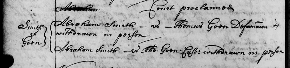
Westmoreland Co orders p 204 Abraham Smith v Thomas Goen
1693 May 31 – Gawen Corbin Gent attachd an attachmt against the estate of Eashaw Goeing for eight hundred and fifty pounds and the sheriff under return that he had it attached one gray horse branded on both buttocks with obscure H brands which a horse has had in custody and a bridle and saddle in the hands of Abraham Smith as being the proper estate of the sd Eashaw Goeing.
Easaw Goeing late of this county being indebted to Mr. Gawen Corbin in the summ of eight hundred and fifteen pounds of tobo by cask as it was said and having absented himself out of the county the sd Corbin obtained an attachment agst the sd Goeings estate by Corbin of which the Sheriff attached one gray horse branded on both buttocks with an obscure brand being the proper estate of the sd Easaw Goeing as by the estate of the sd attachmt doth appeare. And for that it appeared to this court by the oath of Mr James Ellis that the sd Easaw Goeing stood justly indebted to the sd Gawen Corbin in that sum of amt of tobo by ammt for good judgment is granted him for his sd debt and (sp?) and the sd horse being appraised at Eight hundred pounds of tobo and undemaned awarding (sp?). It is ordered the sheriff orer over him to the sd Mr Corbin in part of satisfaction of his sd debt and such.
County Court orders 1690-1698. p. 97. Westmoreland County, Va
https://www.familysearch.org/ark:/61903/3:1:3Q9M-CS4V-6B8K?i=216&cat=382658

“William Gowing, James Gowing and John Gowing” are included in the roster of a company of dragoons commanded by Capt. John West and Lt. John Peake. They are on duty in Stafford County in 1702, according to “Virginia Colonial Soldiers” by Lloyd Bockstruck. The dragoons who are mounted infantrymen, and receive their name from their weapons. The troops carry a musket called the “Dragon” and accordingly are called dragoons. “Virginia Colonial Soldiers” by Lloyd Bockstruck

1701/1702 Stafford County, Virginia – Militia members:
Stafford County, ca 1701/2:
Benjamin Cokely, Lt.; Giles Travers , Lt.; Samuel Burton, Lt.; Dade Massey, Lt.; John West, Jr., Lt .; George Mason, Lt.; Edward Humpstead,Lt.; Thomas Lunn, Cornet; Matthew Tenison, Cornet; Alexander Waugh, Cornet; Benjamin Webb, Ens.; John Peake, Cornet; Moses Linton, Cornet; Stephen Parker, Cornet; George Anderson, Capt.; Thomas Harison, Capt.; Richard Fossaker, Capt. ; Joseph Lumm, Capt.; Philip Alexander, Capt.; G. Mason, Commander in Chief; William Fitzhugh, Maj ; John West; Charles Ellis.
Stafford County:
Company of Dragoons: John West, Capt.; John West, Jr., Lt.; John Peake, Cornet; Thomas Baxter, Sgt.; Humphrey Peake, Sgt.; Simon Person, Sgt.; Thomas Stafford, Corp.; Simon Conill, Corp.; Joseph Case, Corp.; Ambros Ship—, Corp .; G. Mason; John West; John West, Jr.; John Peake; John Harpar; Henry Emerson; John Jones; Thomas Peake; Theofilus Willobe; Robert Blake; Robert Williams; John Ball; Edward Kinington; Thomas Tompson; William Simson; William Harisson; Thomas Gilliborn; Henry Filton; Jan: Mottershad ; John Davis; Richard Carpender; John Gowing; William Gowing; James Gowing; John Musgrove; Henry Hayley; Henry Hayley, Jr.; William Hayley; Richard Cooper; William Cowther; Samuel Jackson; John Gossom; Giles Tillit; Henry Regnay; Joseph Boucher; Thomas Ambros; Daniel Joyner; Richard Hutchison; James Hereford; Henry Gwin; Pack Anderson; Thomas Davis; William Withers; George Pimitt; Richard Cool!; William Howlt; Walter Griffing; Martin Porter.
Troop of Horse of Capt. George Anderson: Giles Travis, Lt.; Alexander Waugh, Cornet; Thomas Gage, Q.M.; Thomas Brook, Corp.; William Habeard, Corp.; John Simons, Corp.; Nicholas Brent; William Brent; John Waugh, Jr.; Thomas Gregg; Row: Travis; Thomas James; Edward Mountjoye; John Mountjoye; Thomas Elsey; Bryan Foley; Garret Banks; Richard Rosser; John Rowley; Peter Beach; Matthew Keen; James Sutler; Augustine Kneaton; James Mann; William Waller; Joseph Waugh; Edward Watts; John Gerery {?); Lawrence Southward; William Matheney; Richard Martin; Francis Wadington; William Allen; Joseph Sumner; Thomas Payton; William Burton.
Capt. Thomas Harrison’s Foot Company: Thomas Harrison, Capt.; George Mason, Lt.; Moses Linton, Ens.; Robert Hoages, Sgt.; William Bennett, Sgt.; George English, Sgt.; Thomas Witledge, Corp.; Thomas Barton, Corp.; George English, Corp.; Richard Meager, Drummer; Samuel Poore; Drummer; Richard Davis; Robert Leech; William Champ; Peter Beech; William James; John Williams; William Mallitt; Matthew Perkins; John Champ; William Perkins; Thomas Perkins; Phillip Johnson; Abraham Bridwell; Jacob Gibson; James Fletcher; John Be–ings; Ralph Smith; Michael Farler; Richard Jones; Marchis Calmees; Thomas Smith; William Davis; John Wadding; Thomas Chapman; Thomas Witledge; William Guess; Charles Guodkin; William Whalley; Isaac Kent; Thomas Masters; John Crouch; William Long; Martin Hulitt; Scarlitt Green; Joseph Whitson; John Simpson,Jr.; Samuel Gibson; Joseph Hunter; Hugh Tomlin; Charles Chrisman; Francis Hackett; Solomon Holmes; William Fields; Henery Walding; Abraham Farrer; John Gosling; John Tharp; William Gosling; James Letherland; William Jennings.
Company of Horse Troops: Richard Fassaker, Capt.; Dade Massey, Lt.; Matthew Tenison, Cornet; Robert Dade, Q.M.; John Smith, Trumpeter; Samuel Todd, Corp.; William Stretton, Corp.; Thomas Wells, Corp.; John Crawford; Gilbert Allsop; Thomas Grubs; Robert Jones; Thomas Derrick; Oliver Littlejohn; Francis Hunt; Thomas Knight; Richard Elkin; Richard Chapman; George Proctor; William Proctor; Thomas ounkham; William Richardson; William Sewell; Robert Duncan; William Baltrop; Simon Smith; William Johnson; James Grigsby; David Lewis; Robert Bowlin; John Murphc; John England; William King; Robert Phipps; Philip Kelley; Robert Lewelling; John Collyer; John Giles.
Company of Horse Troops: Charles Ellis, Capt.; Benjamin Colclough, Lt.; Thomas Lunn, Cornet; Thomas Marshall, Q.M. ; Robert King, Trumpeter; John Arm, Corp.; George Spiller, Corp.; Charles Martin, Corp.; Robert Alexander; John Washinton; Edward Hart; Thomas Gillson; Richard Foote; William Bunbury; John Bunbury; Samuel Wells; John Lilley; Thomas Ellis; Thomas Mosse; Thomas Kitchum; Charles Grigsby; Benjamin Newton; George Downing; Joel Striblin; John Kidwell; Alexander Doniphan; Richard Powell; Charles Ellit; Francis Thornton; Henry Lucas; William Buckner; Ambros Farrlow; Richard Ayliffe; Benjamin Massey; Richard Broad; Robert Cateker (?);John Mope{?).
Virginia’s Colonial Soldiers – Bockstruck – pgs. 219-220.
(Names in bold above are of interest in my research of the Goyen/Going lines – surnames of families with possible connections).https://books.google.com/books?id=0RpcjJQBm6AC&pg=PA219&lpg=PA219&dq=James+Gowing,+John+Gowing,+William+Gowing,+dragoons&source=bl&ots=aUYdKZese1&sig=1y0EvkT1Z-TVNYDRCyOxHMcXFQU&hl=en&sa=X&ved=0CB4Q6AEwAGoVChMIz9iSs5GZyQIVhiomCh3KLA1E#v=onepage&q&f=false
William Gowen is married wife’s name Catherine – unknown date. (Note: Also unknown if he had any prior wives with prior children).
1707 July 18 – Whereas Thomas Goin of sd County of Westmoreland upon his suggestion of a certain quantity of land belonging to us in ye County of Stafford which is not yet granted did on the 18th day of July 1707 obtain a warrant from our office for laying out the saym and having now returned a survey thereof under ye hand of Thomas Gregg, Surveyor: … confirm unto the said Thomas Goin 653 acres of land situate lying and being on Potowmack River side near ye Falls in ye County of Stafford afsd & bounds according to ye sd survey as followeth, Viz: beginning at a markt white oak standing on ye upper side ye mouth of Lower Spout Run by or near ye land called Ousleys Land & extends up ye sd Branch South …
Northern Neck Grants No. 3, 1703-1710, p. 204 (Reel 288)
https://lva.primo.exlibrisgroup.com/permalink/01LVA_INST/altrmk/alma990008536680205756
1708 Va Stafford Co Thomas Goin on quitrent roll

1708 Va Stafford Co Thomas Goin on quitrent roll
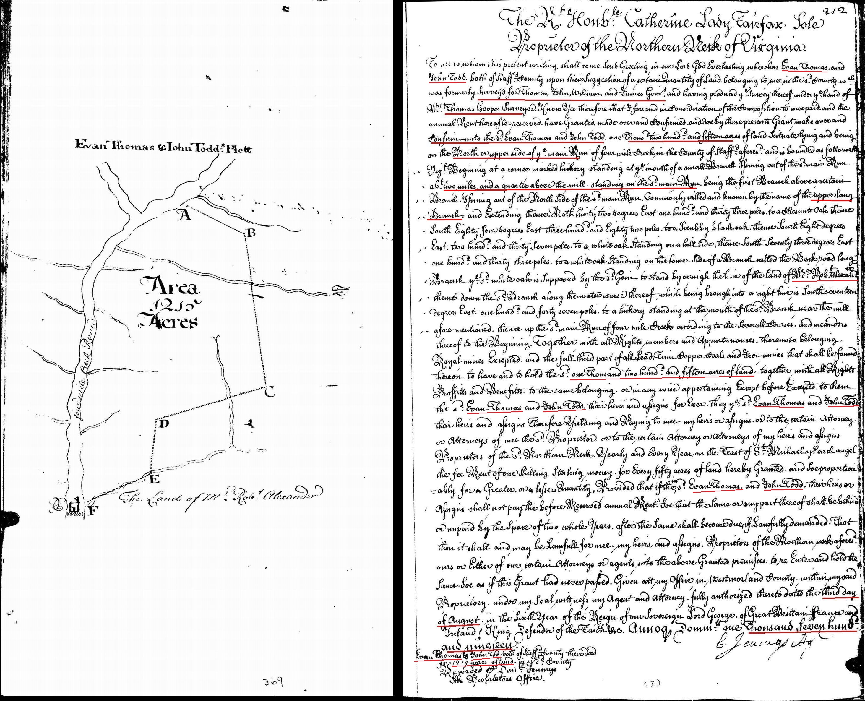
1711-1719 (Estimated): Thomas Goins, John Goins, William Goins, and James Goins receive a survey for 1215 acres adjoining Robert Alexander’s land in Stafford County, Virginia … The Goins then sell their rights to the land to Evan Thomas and John Todd some time before August 3, 1719 as stated in the following land grant … 1719 Aug 3 … wherehas Evan Thomas and John Todd both of Stafford County … a certain quantity of land … in the sd County which was formerly survey’d for Thomas, John, William, and James Goins and having produced the survey thereof under the hand of Mr. Thomas Hooper surveyor … confirm unto the said Evan Thomas and John Todd 1215 acres of land scituate lying and being on the North of upper side of the main run of Four Mile Creek in the County of Stafford … bounded … beginning at a corner marked hickory standing at the mouth of a small branch issuing out of the said main run about 2 miles and a quarter above the mill standing on the sd main run being the first branch above a certain branch issuing out of the north side of the said main run commonly called and known by the name of the Upper Long Branch and extending thence north … to a chesnut oak thence south … to a white oak standing on the lower side of a branch called the Back Road Long Branch the said white oak is supposed by the said Goin to stand by or nigh the line of the land of Mr Robert Alexander thence down the said Branch along the water course therof … to a hickory standing at the mouth of the sd branch nearl the mill aforementioned, thence up the sd main run of Four Mile Creek according to the severall courses and meanders thereof to the begining … fully authorized thereto dated the 3rd day of August … 1719 … Virginia Land Grants. Bk 5, pg 212. (NOTE: The estimated date of the survey by the Goins is based on when Thomas Hooper became a surveyor in Stafford County. He appears to have started surveying in Stafford County in 1711. Thomas Gregg was the surveyor prior to 1711. Thomas Gregg’s records indicate he died some time in 1710-1711)(Note: Evan Thomas later, in 1714, jointly receives a grant of 124 acres of land with William Going on Mason’s Neck).
The Alexander family owned much of the land that eventually would become Alexandria, Virginia – and the name of that city is from the Alexander family that owned the land. For more on Robert Alexander, and the Alexander family, see the history of Alexandria, Virginia – wikipedia article:
https://en.wikipedia.org/wiki/Alexandria,_Virginia
(Note: Additional information on the 1215 acres is found in the depositions taken in 1767-68 in a lawsuit between John Carlyle, plaintiff and Charles Alexander, defendant, the 8th day of May 1767 (a land dispute) according to “Patents and Northern Neck Grants in Fairfax County, Virginia” by Beth Mitchell) (see transcription of the depositions are in the second half of page below in part II. Ancestry/Immigration of Thomas Gowing): 1719 Aug 3 – Thomas Evans 1215 acres, Book 5, p 212 https://www.familysearch.org/ark:/61903/3:1:3Q9M-CSYD-VSGG-M?i=519&cat=414338 (Survey on p. 69)
https://www.familysearch.org/ark:/61903/3:1:3Q9M-CSYD-VSGG-9?i=520&cat=414338 (Grant)
(See Thomas Gowing b. aft. 1650, for additional information on the deposition and litigation over this tract of land).

arlington-county-land-owner-map-1669-to-1796-including-going-lands-1215acres-652acres-and-653acres-marked
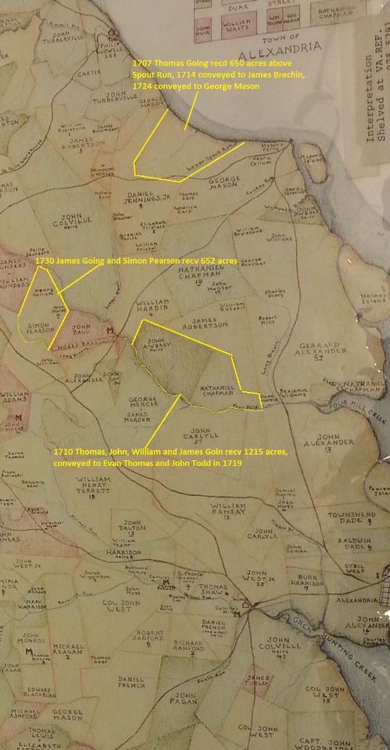
fairfax-map-1760-marked1215acres to Thomas, John, William, and James Goin -653acres to Thomas Going -652acres James Going
1713 Sept 4 – Cornelius Keiffe and Richard Kirkland receives 268 acres. On the North side of Occoquan River. Adj to Richard Ridgewell. Stafford County, Va. 1713 Sept 4 – Cornelius Keiffe and Richard Kirkland 268 acres, Book 5, p 6. https://www.familysearch.org/ark:/61903/3:1:3Q9M-CSYD-VSPM-W?i=157&cat=414338 (Note: Cornelies Keiff is the father of Mary Keith Gowing and Father in Law of John Gowing b. abt. 1700 – son of William Gowing b. abt. 1678. Half of this land is later left to John Gowing and Mary when Cornelius Keiffe dies. The land is then in 1746 is conveyed by John and Mary Gowing to Richard Kirkland decd’s son Edward Kirkland. There is no indication John and Mary Gowing ever lived on this land – Cornelius may have died some time just prior to the conveyance).

1713 Va Land Grant to Cornelius Keife and Richard Kirkland for 268 acres in Stafford Co Va
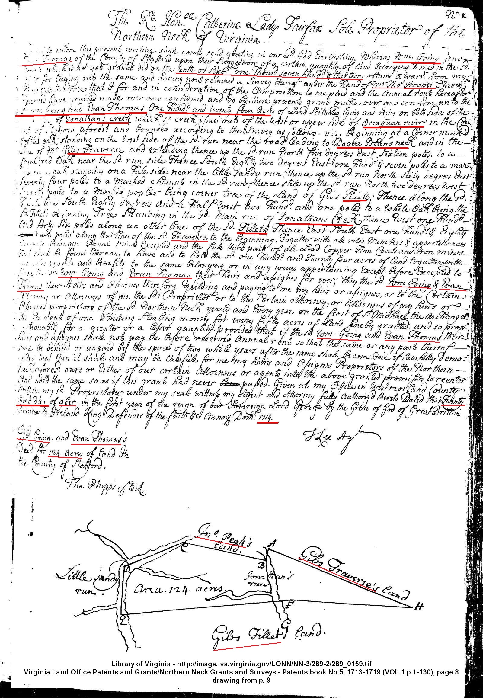
1713 Sept 10 land warrant obtained … On November 23, 1714 William Gowen and Evan Thomas receive a grant of 124 acres in Stafford County from the proprietors, members of the London and Plymouth Companies who receive a grant to all land between the 34th and the 45th parallels, from the Atlantic Ocean to 200 miles inland. At this time William Gowen makes his home in Overwharton Parish of Stafford County. The land is described as “lying on both sides of the main run of Jonathans Creek, which creek issues out of the west or upper side of the road lead of Occoquan River, beginning at a white oak on the west side of the run nearing to Dogue Island neck and in the line of Mr. Giles Traverse,” according to Northern Neck Deed Book 5, page 8. “William Going” and Evan Thomas receive Grant No. 60 for 124 acres November 23, 1714. The land lay in Overwharton Parish “on both sides of the main run of Jonathans Creek, which creek issued out of the west or upper side of Occoquan River, beginning at a white oak on the west side of the run near the road leading to Dogue Island neck and in the line of Mr. Giles’ Traverse … near the Little Sandy Run … corner tree of Giles Tillett … ” according to “Grants by the Proprietors of the Northern Neck of Virginia, 1694-1742.” https://www.familysearch.org/ark:/61903/3:1:3Q9M-CSYD-VSP9-Y?i=160&cat=414338
1714 March 22 – 5-44 – James Brechin of Westmoreland, receives 795 acres . . . adjacent to Tho’s Going. p 57. Va. Land Trans – Stafford Co, Va. On March 22, 1714, recorded December 20, 1716, Thomas Going owns land adjacent to land purchased by James Brechin “two miles below the falls of the Potomac” in Stafford County, Virgina, survey by Thomas Hooper, according to Northern Neck Deed Book 5 page 44.
https://www.familysearch.org/ark:/61903/3:1:3Q9M-CSYD-VSP9-H?i=223&cat=414338
(Note: The following deed in 1724 shows William Going selling 90 acres of the above land to William Godfrey. It is unknown what happened to the other 34 acres).
1724 May 7 … between William Going of the Parish of Overwharton in the County of Stafford and Colony of Virginia of the one part and William Godfrey of the same Parish, County and Colony aforesaid of the other part … William Going … in consideration of the sum of 14,000 pounds of tobacco … paid by the said William Godfrey … confirm unto the said William Godfrey … all that tract or parcel of land lying and being in the Parish of Overwarton in the County of Stafford … on the East side of the main Run of Jonathans Creek being the second bound tree of a parcel of land taken up by William Going and Evan Thomas … to a marked white oak standing on a hillside near the Little Sandy Rune … up the said Run North … to a marked Poplar being the corner tree of the land of Giles Tillett … along the said Tilletts land south … to a white oak being the said Tilletts beginning tree standing in the said main Run of Jonathans Creek thence down the said Run to the beginning tree, containing and now laid out for 90 acres more or less … unto the said William Godfrey this heirs executors administrators or assignees shall and will warrant and forever defend by these presents against him the said William Going his hears executors administrators and assignees and against John Peak Senr of Stafford County in Overwarton Parish and his heirs executors administrators and assignees so claiming …
Signed: William Going
Wit: John Willson, Moses Linton
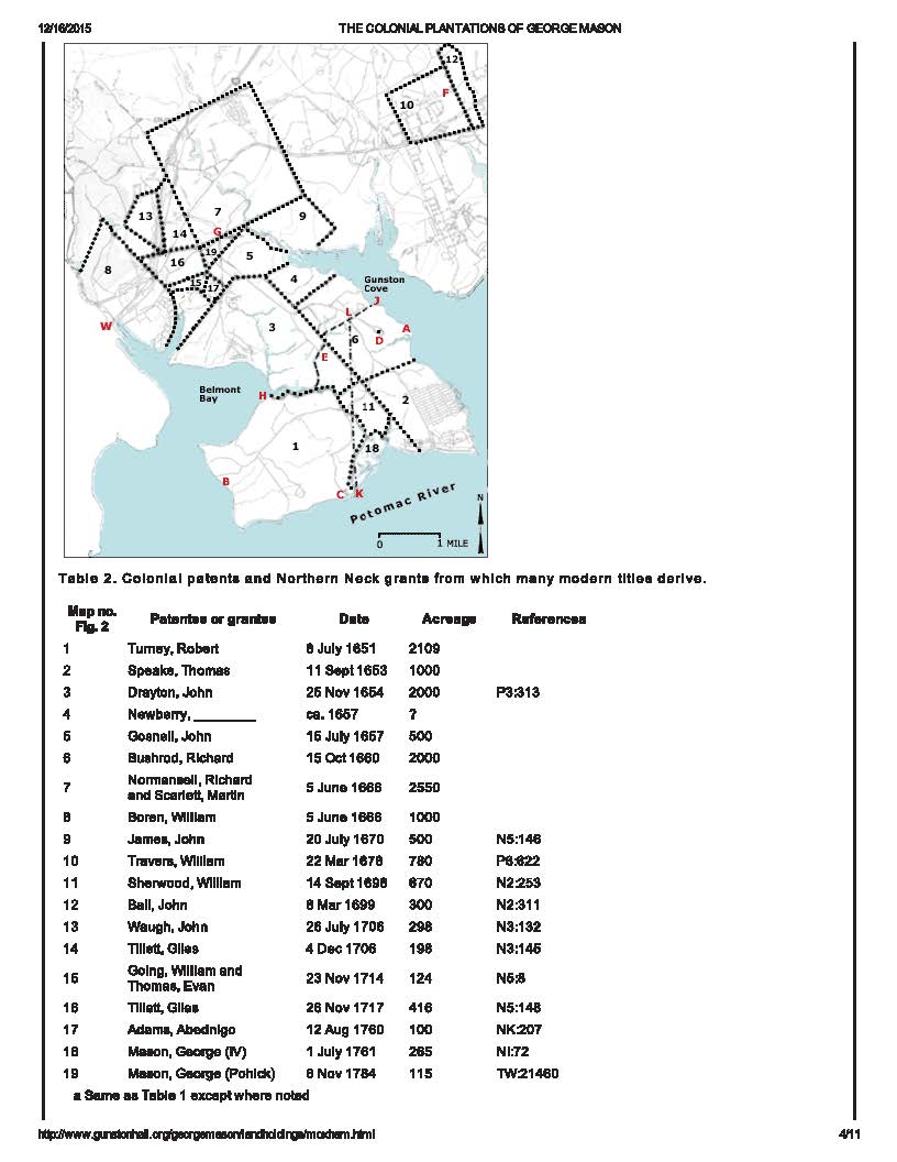
The following map is from George Mason’s website. William Going’s 124 acres purchased in 1714 are listed as number 15 on the map. Those living adjacent to his land are 8 – William Boren, 16 – Giles Tillet, 9 – John Goenell, 17 – George Mason. The elder George Mason had purchased most of the land shown below in the 1690s and leased or sold the land over time. This area was known as “Dogue’s Island” or “Dogue’s Neck”.
This land received in 1714 by William Goin is the land where the historic Minnick House in Virginia is located:
Colonial Settlement:
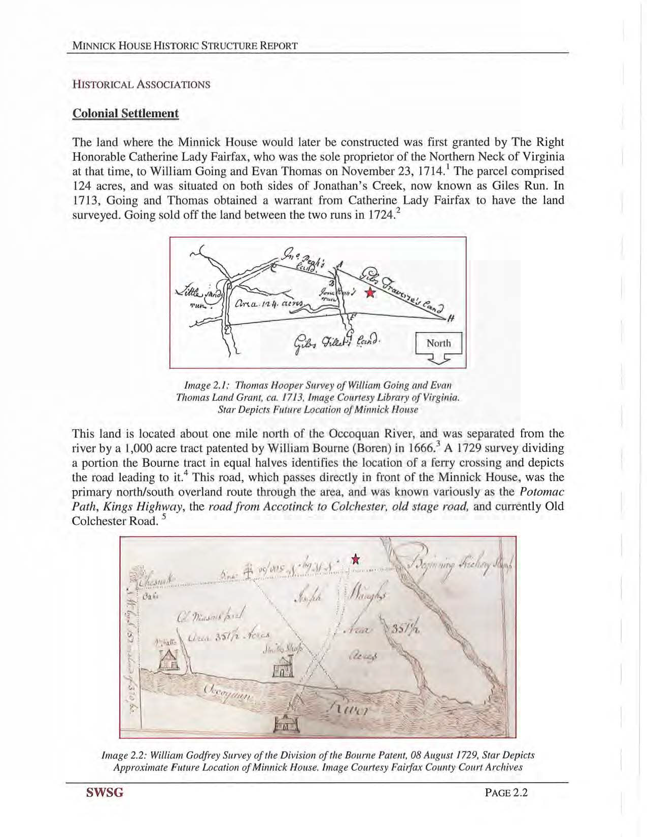
The land where the Minnick House would later be constructed was first granted by The Right Honorable Catherine Lady Fairfax, who was the sole proprietor of the Northern Neck of Virginia at that time, to William Going and Evan Thomas on November 23, 1714. 1 The parcel comprised 124 acres, and was situated on both sides of Jonathan’s Creek, now known as Giles Run. In 1713, Going and Thomas obtained a warrant from Catherine Lady Fairfax to have the land surveyed. Going sold off the land between the two runs in 1724.
This land is located about one mile north of the Occoquan River, and was separated from the river by a 1,000 acre tract patented by William Bourne (Boren) in 1666. 3 A 1729 survey dividing a portion the Bourne tract in equal halves identifies the location of a ferry crossing and depicts the road leading to it.4 This road, which passes directly in front of the Minnick House, was the primary north/south overland route through the area, and was known variously as the Potomac Path, Kings Highway, the road from Accotinck to Colchester, old stage road, and currently Old Colchester Road. 5
(NOTE: Remember John Ferry’s will – where he has cared for the Boreing estate for the Orphans – and calls them his “sons in law” – John Boreing, James Boreing, and Thomas Boreing – sounds like these were possibly his sisters’ sons?).
(Click pictures to enlarge)
1713-minnick-house-historic-info_page_1

1713-minnick-house-historic-info_page_2
Click to access 051315-pd-pkg.pdf
Extending eastward was the road leading to Dogue Island Neck (now Masons Neck). 6 This old road likely passed through Going’s and Thomas’ land grant. The beginning point of Hooper’s survey, indicated in Image 2.1 as A, was noted as being near this road.
1715 Jan 11, Cornelius Keeife, 630 acres; Keeife, Cornelius. grantee.
Title Land grant 11 January 1714/1715. Summary Location: Stafford County.
Description: 630 acres on the south side of Niapscoe Run. Source: Northern Neck Grants No. 5, 1713-1719, p. 34 (Reel 289). Recorded survey available. Northern Neck Grants No.5 1713-1719. (reverse).
1715 Jan 11, Cornelius Keeife receives 630 acres in Stafford County on the south side of Niapscoe Run … beginning at a marked white oak … on the south side of the run, and on the upper side of a small branch … between the two inward marked hickory’s on the sd run side, being corner tree of a tract of 49 acres of land granted to Dennis Cornwall and now in the possession of the sd Cornelius Keeife, thence along a line of makred trees made for the sd Dennis Cornwall … thence along another of the sd lines south … Survey by Thomas Hooper. Source: Northern Neck Grants No. 5, 1713-1719, p. 34 (Reel 289). https://www.familysearch.org/ark:/61903/3:1:3Q9M-CSYD-VSG1-Z?i=205&cat=414338

1715 Jan 11 Survey for Cornelius Keefe 630 acre grant in Stafford Co Va
1719 Feb 28 – “William Goin” receives Grant No. 91 for 180 acres … whereas William Goin of Stafford County upon his suggestion of a certain quantity of land …. did obtain a warrant from my office for laying out the same and having now returned a survey thereof under the hand of Mr. Thomas Hooper surveyor … confirm unto the said William Goin 180 acres of land scituate lying and being on the main run of the Accontink Creek in the County of Stafford … bounded … at a corner mark’d white oak standing on the upper side of the mouth of the Long Branch falling into the said main run on the lower side thereof and extending up the said branch North … to a white oak standing on the lower sid of the said branch thence west … to a red oak … to a small maple standing on the upper side of the aforesde Long Branch … to a black oak … to a small Spanish oak standing on the upper side of a small branch called by the said Goin and others Turkey Branch … to a red oak standing near the aforesaid Main Run and on the upper side of the said branch thence down the said Main Run meandering to the several courses and meanders thereof to the beginning … according to “Grants by the Proprietors of the Northern Neck of Virginia, 1694-1742.” Northern Neck Deed Book 5, page 229.
https://www.familysearch.org/ark:/61903/3:1:3Q9M-CSYD-VSGK-6?i=549&cat=414338
1719 survey for 180 acres for William Goin in Stafford Co Va

Library of Virginia Accontink Creek is a tributary of the Rappahannock River which forms the southern boundary of Stafford County. (Note: It is unknown how this land was disposed of. There are no records in the deed books that do survive indicating who this land was sold to, or whether it was inherited by one of William Goin’s heirs).
1719 Aug 3 – 5-212: Evan Thomas and John Todd both of Stafford Co, reveive 1215 acres in Stafford Co on Four Mile Cr adjacent to Mr. Robert Alexander, land formerly surveyed for Thomas, John, William, and James Goins. This land is apparently sold to Thomas and Todd by the Goins according to depositions regarding the land taken in 1767 of Charles Griffith and David Thomas. https://www.lva.virginia.gov/chancery/case_detail.asp?CFN=013-1811-021. Surv. by Mr. Thomas Hooper. 3 Aug 1719. p. 69. (pages 369 and 370). 1719 info on Going family ownership of 1215 acres in Stafford Co, Va. Book 5, p 212 (Survey on p. 69)
https://www.familysearch.org/ark:/61903/3:1:3Q9M-CSYD-VSGG-9?i=520&cat=414338
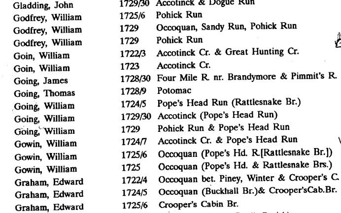
1722/23 William Goin on Accotink Cr and Great Hunting Cr, in Stafford Co, Va, Northern Neck residents and landowners. Stafford County Virginia Titheables. 1723-1790 in two volumes, compiled by John Vogt and T. William Kethley Jr. Volume 1, page 117, 143.

1722 to 1727 Stafford Co Va residents and landowners including William Goin
1723 William Goin on Accotink Cr and Great Hunting Cr, in Stafford Co, Va, Northern Neck residents and landowners. Stafford County Virginia Titheables. 1723-1790 in two volumes, compiled by John Vogt and T. William Kethley Jr. Volume 1, page 117, 143.
1723 Quit Rent Roll in Stafford Co Va with William Goin 266 acres
1723 William Goin listed on quitrent rolls for 266 acres taken away by Colonel Lee’s survey in Stafford County, Va. Stafford County Virginia Titheables. 1723-1790 in two volumes, compiled by John Vogt and T. William Kethley Jr. Volume 1, page 9. also, The Register of Overwharton Parish, Stafford County Virginia, 1723-1758, and Sundry Historical and Genealogical Notes. Compiled and Published by George Harrison Sanford King. pg. 149.
1723 – Virginia, Compiled Census and Census Substitutes Index, 1607-1890
Name: Wm Goin
State: VA
County: Stafford County
Township: Rental Rolls
Year: 1723
Record Type: Rent Role
Database: VA Early Census Index
Ancestry.com. Virginia, Compiled Census and Census Substitutes Index, 1607-1890 [database on-line]. Provo, UT, USA: Ancestry.com Operations Inc, 1999.
https://search.ancestry.com/cgi-bin/sse.dll?indiv=1&dbid=3578&h=33941621&tid=&pid=&usePUB=true&_phsrc=kUu4520&_phstart=successSource
1724 May 4 warrant for William Gowin assigned to William Moor of Stafford Co, Va for 480 acres – survey done on May 19, 1727 … on the branches of Accotinck … by land of Coll George Mason …. corner to land of Walter Griffin … May 19, 1727 survey date in Stafford Co, Va 1724 May 4 – William Gowin’s assigned 480 acre grant to William Moore, Book B, p 103
https://www.familysearch.org/ark:/61903/3:1:3Q9M-CSY6-W93D-X?i=359&cat=414338 http://image.lva.virginia.gov/LONN/NN-1/240/0464_0466.pdf
The land that William Gowin assigned to William Moore in 1724 was not actually granted to William Moore until January of 1728:
1728 Jan 17 granted land … confirm unto William Moore of Stafford County one certain tract or parcel of land containing 480 acres situate … in the said County on the branches of Accotink and is bounded … beginning at a white oak standing nigh a poplar on the south branch of Accotink corner to the land of Col. George Mason thence down sd branch dividing this land from the sd Mason’s South … to a red oak on the head of a branch of Popeshead … to a white oak corner to the land of Walter Griffen thence binding therewith North … Virginia Land Grants, bk B, pg 103. https://www.familysearch.org/ark:/61903/3:1:3Q9M-CSY6-W93D-X?i=359&cat=414338

1727 May 19 survey William Moor assignee of William Gowin for 480 acres in Stafford Co Va snip 1

1727 May 19 survey William Moor assignee of William Gowin 480 acres Stafford Co Va
1724 May 6 – (Lease): … between William Going of Parish of Overwharton in the County of Stafford and Colony of Virginia of the one part and William Godfrey of the aforesaid parish, county & colony … William Going … paid by the said William Godfrey … doth grant bargain sell alien demise lease and to farm letten unto the said William Godfrey … all that tract or parcel of land lying and being in the Parish of Overwharton and County of Stafford … on the East side of the main run of Jonathans Creek being the second bound tree of a parcel of land taken up by William Going and Evan Thomas … to a marked white oak standing on a hill side near the Little Sandy Run … up the said Run north …. to marked poplar being the corner tree of the land of Giles Tillett … along the said Tillets line … containing and now laid out for 90 acres more or less … from the day of the date herof for and during the full end and term of three years …
Signed: William Going
Wit: John Willson, Moses Linton
Recorded: May 13, 1724.
(Power of Attorney): Then name Lewis Sanders who by virtue of a power of attorney from William Going duly proved in Court by the oathe of John Willson and William O’Daniel witnesses thereto subscribed and acknowledged this deed to William Godfrey which was ordered to be recorded. Test: George Mason.
(Release): … 1724 May 7 … between William Going of the Parish of Overwharton in the County of Stafford and Colony of Virginia of the one part and William Godfrey of the same Parish, County and Colony aforesaid of the other part … William Going … in consideration of the sum of 14,000 pounds of tobacco … paid by the said William Godfrey … confirm unto the said William Godfrey … all that tract or parcel of land lying and being in the Parish of Overwarton in the County of Stafford … on the East side of the main Run of Jonathans Creek being the second bound tree of a parcel of land taken up by William Going and Evan Thomas … to a marked white oak standing on a hillside near the Little Sandy Rune … up the said Run North … to a marked Poplar being the corner tree of the land of Giles Tillett … along the said Tilletts land south … to a white oak being the said Tilletts beginning tree standing in the said main Run of Jonathans Creek thence down the said Run to the beginning tree, containing and now laid out for 90 acres more or less … unto the said William Godfrey this heirs executors administrators or assignees shall and will warrant and forever defend by these presents against him the said William Going his hears executors administrators and assignees and against John Peak Senr of Stafford County in Overwarton Parish and his heirs executors administrators and assignees so claiming …
Signed: William Going
Wit: John Willson, Moses Linton
(Power of Attorney)… William Going of the County of Stafford and Colony of Virginia do constitute and appoint my well beloved friend Lewis Sanders of the County of Stafford and Colony of Virginia my Attorney to acknowledge for me and in my name in the Court of the said County of Stafford certain deeds of lease and release for 90 acres of land in the said County unto William Godfrey of the said County and Colony aforesaid … 7th day of May 1724.
Signed: William Going
Wit: John Willson, William O’Daniel.
… At a Court held for Stafford County the 13th day of May Anno Dom 1724
Then came Lewis Sanders who by virtue of a power of attorney from William Going duly proved in Court by the Oaths of John Willson and William O’Daniel witnesses thereto … the deed of release to William Godfrey … Test. Geo. Mason C. Clk
https://www.familysearch.org/ark:/61903/3:1:3Q9M-C9PF-ZQRW?i=71&cat=366578
On July 13, 1724, Capt. Charles Broadwater of Stafford Co receives 388 acres, adjacent to William Going. “Stafford County, Virginia Deeds, 1722-1728.” Book A, Page 40. p. 74.
1724 July 13 (Northern Neck Land Grants, bk A, p. 40) … whereas Capt. Charles Broadwater of the County of Stafford County … confirm unto the said Charles Broadwater 388 acres of land situate lying and being on the Main Run of Accotink Creek in the County of Stafford … bounded on the lower side of the Mouth of a small branch issuing out of the Main Run on the Eastwardly or lower side thereof and opposite to the upper end of the plantation William Going now lives on and extending thence unp the said small branch … to a creek standing at the mouth of another small branch falling tinto the aforesaid small branch …
https://www.familysearch.org/ark:/61903/3:1:3Q9M-CSY6-W979-6?i=54&cat=414338

http://image.lva.virginia.gov/LONN/NN-3/290-1/1-100.html
Charles Broadwater’s survey for 388 acres adjacent to William Goins land where he was living at the time:
1723 Nov 30 Charles Broadwater survey for 388 acres adjacent William Goin in Stafford Co Va
1722 Oct 1 (warrant) – (missing)
1723 Nov 30 (survey) – Nov 30th, 1723, Survey’d for Capt Charles Broadwater of the County of Stafford by virtue of a warrant fro the Proprietors Office bearing date the 1st day of October 1722 a certain tract or parcell of land situate lying and being on the Main Run of Accotinck Creek in the County of Stafford aforesd and is bounded … on the lower side of the mouth of a small branch issuing out of the Main Run on the Easterly or lower side thereof and opposite the the upper end of the Plantation William Goin now lives on and extending thence … to a Beach standing at the mouth of another small branch falling into the aforesd small branch … to a Beach standing on the aforementioned Main Run side and at the mouth of the said branch thence up the sd Main Run side … containing …. 388 acres... Survey’d by Tho Hooper, Surveyor.
http://image.lva.virginia.gov/LONN/NN-1/239/0355_0357.pdf

Charles Broadwater survey for 388 acre grant adjacent to William Goins 180 acre grant on Accotink Creek
1724 July 20 – William Goin is mentioned as owning land adjacent to John Linton in Stafford County, Virginia:
1724 July 20 (Northern Neck Land Grants, bk A, p. 46) … whereas John Linton of the County of Stafford … did obtain a warrant from our office for laying out … 382 acres of land situate lying and being on the Main Run of Accotink Creek in the County of Stafford … bounded … at a small corner white Oak standing on the lower side of the Mouth of a small branch issuing out of the said Main Run on the Eastward or lower side thereof and opposite to the upper end of the plantation William Goin now lives on being also the beginning tree of 388 acres of land surveyed at this time for Capt. Charles Broadwater and extending thence up the said small branch … dividing this land from the land of the said Broadwater to a beach standing in the mouth of another small branch falling into the aforesaid small branch being corner tree also to the said Broadwaters land … standing on the said Main Run side at the foot of a steep hill and at the lower end of a piece of low ground thence down the said Main Run …
https://www.familysearch.org/ark:/61903/3:1:3Q9M-CSY6-W9QM-H?i=60&cat=414338
John Linton survey Dec 30 1723 for 382 acres adj William Going in Stafford Co Va
1723 Dec 30 (survey) – Survey’d for Mr John Linton of the County of Stafford by virtue of a warrant from the Proprietors Office …. a certain tract or parcell of land situate lying and being on the Main Run of Accotinck Creek in the County of Stafford aforesd and is bounded as followeth viz: Beginning at a small white oak standing on the lower side of the Mouth of a small branch issueing out of the said Main Run on the Easterly or Lower side thereof and opposite to the upper end of the plantation of William Goin now lives on being also the beginning tree of 388 acres of land surveyed at this time for Capt Charles Broadwater and extending thence up the sd small branch … dividing this land from the land of the sd Broadwater to a Beach standing in the mouth of another small Branch falling into the aforesd small branch being corner tree also to the sd Broadwater’s land… containing… 382 acres of land… Surveyed by Tho Hooper, surveyor. S. C.
http://image.lva.virginia.gov/LONN/NN-1/240/0389_0391.pdf

John Linton survey for 382 acres grant adjacent to William Goins 180 acres grant on Accotink
1724/5 William Going on Pope’s Head Run (Rattlesnake Br.) in Stafford Co, Va, Northern Neck residents and landowners. Stafford County Virginia Titheables. 1723-1790 in two volumes, compiled by John Vogt and T. William Kethley Jr. Volume 1, page 117, 169.
1721 to 1729 titheables in Stafford Co Va with William Going, Thomas Going, and James Going
1725 William Gowin on Occoquan (Pope’s Head Run at Rattlesnake Br) in Stafford Co, Va, Northern Neck residents and landowners. Stafford County Virginia Titheables. 1723-1790 in two volumes, compiled by John Vogt and T. William Kethley Jr. Volume 1, page 117, 166.
1725 Feb 12 – A-200: granted to Thomas Ford of Stafford Co 282 acres in said Co on Popeshead Br of Occaquan adj. to William Gowin. 12 Feb 1725. p 83. Northern Neck Deed Book A, page 200. “William Gowin” owns land adjoining Thomas Ford “on Popeshead Run and Occoquan Creek” February 12, 1725, according to Northern Neck Deed Book A, page 200. 1725 Feb 12 – William Gowin adj to Thomas Ford, Book A, p 200
https://www.familysearch.org/ark:/61903/3:1:3Q9M-CSY6-W93K-5?i=214&cat=414338 http://image.lva.virginia.gov/LONN/NN-1/240/0081_0083.pdf

1725 Feb 12 Thomas Ford survey for 282 acres in Stafford Co Va
Library of Virginia – 1725 grant to Ford next to Gowin
“William Goings” receives Grant No. 131 November 12, 1725 for 112 acres “on Rattlesnake Branch of Popeshead,” according to “Grants by the Proprietors of the Northern Neck of Virginia.”

Library of Virginia – 112 acres to William Gowing
“William Gowin” owns land “adjoining Terrence Ryley on Popeshead Run and Rattlesnake Branch,” according to Northern Neck Deed Book B, page 79, as reported in “Patents and Northern Neck Grants of Fairfax County, Virginia.” This land is regranted in 1767 to George Mason, with 19 “surplus” acres, according to Northern Neck Deed Book O, page 89.
1725 Sept 30 – By virtue of a warrant from the Proprietors Office dated 30th day of September 1725 surveyed for Terrence Ryley of the County of Stafford 217 acres of land lying and being in the County aforesd on the branches of Popeshead, it being a branch issuing out of the N side of Occoquan River and is bounded as follows … corner to the land surveyed for William Gowin on a branch of the sd called Rattle Snake Branch … March 6, 1726/7.
John Savage, Stafford Co, surveyor. (Original Survey of Land).
http://image.lva.virginia.gov/LONN/NN-1/241/0053_0055.pdf
1727 Apr 14 – B-79: Terrence Ryley of Stafford Co 217a in Stafford Co . . . adj Wm. Gowin on Rattlesnake Br. p. 90. Va. Land Trans – Stafford Co, Va. 1727 Apr 14 – William Gowen adj to Terrence Ryley, Book B, p 79. https://www.familysearch.org/ark:/61903/3:1:3Q9M-CSY6-W9QN-Z?i=335&cat=414338

1725 Sept 30 survey for Terrence Ryley 217 acres adj William Gowin in Stafford Co Va
(Note: The above Terrence Ryley dies without heirs and Robert Carter Jr the obtains the land in the land grant below)
1731 May 16 … Whereas Robert Carter Junior of the County of Westmoreland … did on the 23d day of November … that Terence Reyley of the County of Stafford (now Prince William County) died seized of 217 acres of land in the said County without heirs or making any legal disposition thereof in his lifetime, Whereupon an inquisition concerning the said land is since taken and returned to our said office … John Peyton … brought in this verdice … “We do find that Terence Reyley died seized of 217 acres of land, as appears to us by certain deed from the Honorable the Proprietors of the Northern Neck, bearing date the 14th day of April 1727 … Reyley did not dispose of the said land in his life time, not left any heir that we know of; therefore we find that the aforesaid 217 acres of land doth escheat as by the said inquisition, bearing date the 14th day of April in the year 1731, doth and may more at large appear, and the said Robert Carter being the first presenter and desirous to be admitted tenant of the said land … grant and confirm unto the said Robert Carter all that said tract or parcel of land containing 217 acres … in the said County of Prince William on the branches of Popes head (it being a branch issuing out of the North side of Occoquon River) and bounded as followeth, viz … corner to the land surveyed for William Going on a branch of the said run called Rattle Snake Branch … across the said branch North … corner to the land of Thomas Ford and to the land of the said Going … thence binding with the said Going’s land North …
https://www.familysearch.org/ark:/61903/3:1:3Q9M-CSY6-W9Q9-X?i=788&cat=414338
(Note: The following survey gives a good description of where William Going’s land was located on Rattlesnake Run) 1729 Nov 15 – By virtue of a warrant from the proprietors office dated the 5th day of August 1729. Surveyed for Mr Charles Carter of the County of Lancaster a certain parcel of land situate lying and being in the County of Stafford on the head branches of Pohick and Popes Head Runs and joyning to the lands of Terence Ryley; the said land being bounded as followeth … land of Terence Ryley and extending thence with the sd Ryleys lines … by Walter Griffins rolling road … near Widow Coffer’s line … 875 acres … (William Going’s land is in the center of the drawn survey)
http://image.lva.virginia.gov/LONN/NN-1/239/0391_0393.pdf

1729 Nov 15 Survey for Charles a Robert Carter Jr near William Going in Stafford Co, Va
1725 Nov 9 survey for Thomas Ford for 282 acres adjacent to William Gowin in Stafford Co Va … a warrant …. dated 19th day of August 1725 surveyed for Thomas Ford of Stafford County 282 acres of land lying and beign on a branch of Occoquan known by the name of Popes Head … beginning of a tract of land lately surveyed for William Gowin … by the mouth of a branch called the Rattle-snake Branch of Popes Head … to a p’cell of land of ye sd Gowin’s … plat annexed Nov 9th, 1725. Signed: P M Savage. Stafford Co, Va http://image.lva.virginia.gov/LONN/NN-1/240/0081_0083.pdf 1725 Feb 12 – William Gowin adj to Thomas Ford, Book A, p 200
https://www.familysearch.org/ark:/61903/3:1:3Q9M-CSY6-W93K-5?i=214&cat=414338

1725 Nov 9 survey for Thomas Ford for 282 acres adj William Gowin in Stafford Co Va
1726 March 6 – (Lease): … between Ambrose Gowing of the Parish of Overwarton in the County of Stafford planter of the one part and Catherine Gowing of the same Parish & County widow of the other part … Ambrose Gowing doth heareby acknowledge hath bargained and sold and by these presents doth bargain & sell unto the said Catherine Gowing … one certain tract or parcel of land containing 112 acres situate … in the said County of Stafford on a branch issuing out of a Run called Popes Head the said branch known by the name of Rattlesnake Branch bounded … at a white oak standing in the fork of the said branch …
Signed: Ambros Goin
Wit: Geo Mason, Joseph Hannis, Brent Huttnal.
At a Court held for Stafford County the 8th day of March 1726.
Ambrose Goin acknowledged his deed of lease to Catherine Goin which on her motion is admitted to record.
(Release): 1726 March 7 … between Ambrose Gowing of the Parish of Overwharton in the County of Stafford Planter of the one part & Catherine Gowing of the same parish & County widow of the other part … Ambrose Gowing for & in consideration of the sum of twenty pounds current money … paid by the said Catherine Gowing … confirm unto the said Catherine Gowing … one certain tract or parcel of land containing 112 acres … in the said County of Stafford and branch issueing out of a Run called Popeshead, the said Branch known by the name of Rattlesnake branch bounded … beginning at a white oak standing in the fork of the said Branch and extending thence South … as the same is granted by the Proprietors of the Northern Neck of Virginia unto William Gowing Father of the said Ambrose Gowing by Patent bearing date the 12th day of November in the year of our Lord God 1725 … which the said land and premises came and defended to and upon the said Ambrose Gowing as son and heir of the aforesaid William the patentee who died intestate ….
Signed: Ambrose Goin
Wits: George Mason, Joseph Hannis, Brent Nutthall.
I the within named Ambrose Gowing do hereby acknowledge to have received of the within named Catherine Gowing the sum of 20 pounds current mony being the consideration metioned in the within deed to be paid by her to me on the perfection thereof witness my hand this 7th day of arch anno Dom. 1726.
Signed: Ambrose Goin
Wit: George Mason, Joseph Hannis, Brent Nutthall.
At a Court held for Stafford County the 8th day of March 1726.
Ambrose Goin acknowledged this his deed of release with the receipt thereon endorsed to Catherine Goin which on her motion is admitted to record. Test. Catesby Cocke.
https://www.familysearch.org/ark:/61903/3:1:3Q9M-C9PF-Z3Y8?i=186&cat=366578
Later John Gowen, son of William Gowen, inherits a 56 acre portion of this grant, according to Fairfax County deed records. In 1744 John Gowen sells the 56 acres to Thomas Ford. Another son of William Gowen, Alexander Gowen, sells the remaining 56 acres of this 112 acre tract of land land in 1747 to Bond Veal.
1726 March 6 – (Lease): … between Ambrose Gowing of the Parish of Overwarton in the County of Stafford planter of the one part and Catherine Gowing of the same Parish & County widow of the other part … Ambrose Gowing doth heareby acknowledge hath bargained and sold and by these presents doth bargain & sell unto the said Catherine Gowing … one certain tract or parcel of land containing 112 acres situate … in the said County of Stafford on a branch issuing out of a Run called Popes Head the said branch known by the name of Rattlesnake Branch bounded … at a white oak standing in the fork of the said branch …
Signed: Ambros Goin
Wit: Geo Mason, Joseph Hannis, Brent Huttnal.
At a Court held for Stafford County the 8th day of March 1726.
Ambrose Goin acknowledged his deed of lease to Catherine Goin which on her motion is admitted to record.
(Release): 1726 March 7 … between Ambrose Gowing of the Parish of Overwharton in the County of Stafford Planter of the one part & Catherine Gowing of the same parish & County widow of the other part … Ambrose Gowing for & in consideration of the sum of twenty bounds current money … paid by the said Catherine Gowing … confirm unto the said Catherine Gowing … one certain tract or parcel of land containing 112 acres … in the said County of Stafford and branch issueing out of a Run called Popeshead, the said Branch known by the name of Rattlesnake branch bounded … beginning at a white oak standing in the fork of the said Branch and extending thence South … as the same is granted by the Proprietors of the Northern Neck of Virginia unto William Gowing Father of the said Ambrose Gowing by Patent bearing date the 12th day of November in the year of our Lord God 1725 … which the said land and premises came and defended to and upon the said Ambrose Gowing as son and heir of the aforesaid William the patentee who died intestate ….
Signed: Ambrose Goin
Wits: George Mason, Joseph Hannis, Brent Nutthall.
I the within named Ambrose Gowing do hereby acknowledge to have received of the within named Catherine Gowing the sum of 20 pounds current mony being the consideration metioned in the within deed to be paid by her to me on the perfection thereof witness my hand this 7th day of arch anno Dom. 1726.
Signed: Ambrose Goin
Wit: George Mason, Joseph Hannis, Brent Nutthall.
At a Court held for Stafford County the 8th day of March 1726.
Ambrose Goin acknowledged this his deed of release with the receipt thereon endorsed to Catherine Goin which on her motion is admitted to record. Test. Catesby Cocke.
https://www.familysearch.org/ark:/61903/3:1:3Q9M-C9PF-Z3Y8?i=186&cat=366578 (Note: This transaction’s wording may indicate that Ambrose Gowing is the son of William Gowing, but not the son of Catherine. If this is true, then William Gowing may have been previously married and had children prior to his marriage to Catherine. The transaction never indicates that Catherine widow of William is Ambrose’s mother. The fact that Ambrose inherits the entire 112 acres raises questions. There are no records found that indicate what happened to William’s 180 acres on Accotink Creek – nor what happened with his remaining interest in 34 acres on Jonathan’s Creek. These may have been addressed in his inventory and estate paperwork that is noted in Will Book K’s index – but the book itself was stolen or destroyed during the Civil War – so there is no way to know what was in the esate paperwork).
Later John Gowen, son of William Gowen, inherits a 56 acre portion of this grant, according to Fairfax County deed records. In 1744 John Gowen sells the 56 acres to Thomas Ford. Another son of William Gowen, Alexander Gowen, sells the remaining 56 acres of this 112 acre tract of land land in 1747 to Bond Veal.
1725/26 William Gowin on Occoquan (Pope’s Head Run at Rattlesnake Br) in Stafford Co, Va, Northern Neck residents and landowners. Stafford County Virginia Titheables. 1723-1790 in two volumes, compiled by John Vogt and T. William Kethley Jr. Volume 1, page 117, 166.
1724-27 William Gowin on Accotink Cr and Pope’s Head Run in Stafford Co, Va, Northern Neck residents and landowners. Stafford County Virginia Titheables. 1723-1790 in two volumes, compiled by John Vogt and T. William Kethley Jr. Volume 1, page 117, 143.
1721 to 1729 titheables in Stafford Co Va with William Going, Thomas Going, and James Going
1725/26 William Gowring, decd. 1725/6.
Section: Stafford County Wills, Administrations, Inventories, Etc. 1664-1760. Ancestry.com. Virginia Will Records [database on-line]. Provo, UT, USA: Ancestry.com Operations, Inc., 2008. Original data:Judith McGhan. Virginia Will Records. Baltimore: Genealogical Publishing Co., Inc., 1993.
https://www.ancestry.com/sharing/44290?token=uIOVHpp%2BxYnxUy%2BeVMkKtvkpRpTUOuQbkJ5v9sSRQEk%3D
1726 William Gowing (Goin?), decd. 1726.
Section: Stafford County Wills, Administrations, Inventories, Etc. 1664-1760. Ancestry.com. Virginia Will Records [database on-line]. Provo, UT, USA: Ancestry.com Operations, Inc., 2008. Original data:Judith McGhan. Virginia Will Records. Baltimore: Genealogical Publishing Co., Inc., 1993.
https://www.ancestry.com/sharing/44290?token=uIOVHpp%2BxYnxUy%2BeVMkKtvkpRpTUOuQbkJ5v9sSRQEk%3D
1727 William Goin. p 253, inventory; p 269, Estate A/C.
Section: A Missing Will Book of Stafford County and Its Contents. pg. 370. Ancestry.com. Virginia Will Records [database on-line]. Provo, UT, USA: Ancestry.com Operations, Inc., 2008. Original data:Judith McGhan. Virginia Will Records. Baltimore: Genealogical Publishing Co., Inc., 1993.
https://www.ancestry.com/sharing/44257?token=n%2BeswvGoOv2StfeU3AP2kMiJcSV36Qw84kNkm39Pd2U%3D
1727/8 William Gowry. page 268, inventory.
Section: A Missing Will Book of Stafford County and Its Contents. Ancestry.com. Virginia Will Records [database on-line]. Provo, UT, USA: Ancestry.com Operations, Inc., 2008. Original data:Judith McGhan. Virginia Will Records. Baltimore: Genealogical Publishing Co., Inc., 1993.
https://www.ancestry.com/sharing/44257?token=n%2BeswvGoOv2StfeU3AP2kMiJcSV36Qw84kNkm39Pd2U%3D
William Gowen dies sometime between November/December of 1725 and March 6, 1726, at about age 42. His will and probate records have not been found in Stafford County records, but indexes to those books have been found and have the following notations:

Ancestry.com link to source , Ancestry.com link to source , Ancestry.com link to source , Ancestry.com link to source
“It is believed that Catherine Gowen was remarried about 1728, husband’s name Padderson [or Patterson] and removed to adjoining Prince William County, Virgnia.
1728/29 – In 1728/29 Thomas Going is on the tithe list living on the Potomack River in Stafford Co, Va, Northern Neck, listed as one of the “residents and landowners”. (Source): Stafford County Virginia Titheables. 1723-1790 in two volumes, compiled by John Vogt and T. William Kethley Jr. Volume 1, page 117, 169.
1729 William Going on Pohick Rn and Popes Head Run in Stafford Co, Va, Northern Neck residents and landowners. Stafford County Virginia Titheables. 1723-1790 in two volumes, compiled by John Vogt and T. William Kethley Jr. Volume 1, page 117, 169.
1729/30 William Going on Accotink (Pope’s Head Run) in Stafford Co, Va, Northern Neck residents and landowners. Stafford County Virginia Titheables. 1723-1790 in two volumes, compiled by John Vogt and T. William Kethley Jr. Volume 1, page 117, 142.
1729/30 William Going on Pohick Run and Pope’s Head Run in Stafford Co, Va, Northern Neck residents and landowners. Stafford County Virginia Titheables. 1723-1790 in two volumes, compiled by John Vogt and T. William Kethley Jr. Volume 1, page 117.
1721 to 1729 titheables in Stafford Co Va with William Going, Thomas Going, and James Going

1729 to 1730 Stafford Co Va residents and land owners including William Going
1729 Feb 18 – C-28 – Capt. Simon Pearson of Stafford Co 195 acres in Stafford Co . . . adj Thomas Going, Parson Brechin, Col. George Mason, near Potomack R. p. 101, Northern Neck Deed Book 6. page 28. Va. Land Trans – Stafford Co. Va. – On February 18, 1729 Thomas Going owns land adjacent to Capt. Simon Pearson, Parson Brechin, and Col. George Mason near the Potomack River, listed in a land transaction by Capt. Simon Pearson of Stafford Co, Virginia according to the Northern Neck Deed Book 6. page 28. p. 101. “Thomas Going” owns property adjoining Simon Pearson February 18, 1729, according to Northern Neck Deed Book 6. page 28. 1729 Feb 18 – Thomas Going adj to Capt Simon Pearson, Parson Brechin, Col George Mason, Book C, p 28.
https://www.familysearch.org/ark:/61903/3:1:3Q9M-CSY6-W93Z-9?i=554&cat=414338
1729 June 26 survey Simon Pearson for 195 acres adjacent to Thomas Going in Stafford Co Va http://image.lva.virginia.gov/LONN/NN-1/240/0523_0527.pdf

1729 June 26 survey Simon Pearson for 195 acres adjr Thos Going in Stafford Co Va snip 1

1729 June 26 survey Simon Pearson for 195 acres adjr Thos Going in Stafford Co Va snip 2

1729 June 26 survey Simon Pearson for 195 acres adjr Thos Going in Stafford Co Va snip 3

1729 June 26 survey Simon Pearson for 195 acres adjr Thos Going in Stafford Co Va snip 4
1729 Nov 15 – By virtue of a warrant from the proprietors office dated the 5th day of August 1729. Surveyed for Mr Charles Carter of the County of Lancaster a certain parcel of land situate lying and being in the County of Stafford on the head branches of Pohick and Popes Head Runs and joyning to the lands of Terence Ryley; the said land being bounded as followeth … land of Terence Ryley and extending thence with the sd Ryleys lines … by Walter Griffins rolling road … near Widow Coffer’s line … 875 acres … (William Going’s land is in the center of the drawn survey)
http://image.lva.virginia.gov/LONN/NN-1/239/0391_0393.pdf
1729 Nov 15 Survey for Charles a Robert Carter Jr near William Going in Stafford Co, Va
1730 Feb 15 – C-105 – Thomas Ford of Stafford Co 451 acres in Stafford Co on Popeshead Run . . . adj. Capt Connyers and William Going. p106. Va. Land Trans – Stafford Co, Va 1730 Feb 15 – William Going adj to Thomas Ford and Capt. Conyers, Book C, p 105
https://www.familysearch.org/ark:/61903/3:1:3Q9M-CSY6-W9Q4-B?i=706&cat=414338
1730 Mar 31 survey for Thomas Ford for 451 acres adj William Gowin in Stafford Co Va http://image.lva.virginia.gov/LONN/NN-1/240/0084_0087.pdf

1730 Mar 31 survey for Thomas Ford for 451 acres adj William Gowin in Stafford Co Va snip 1
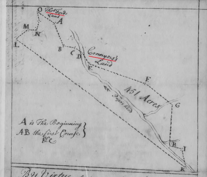
1730 Mar 31 survey for Thomas Ford for 451 acres adj William Gowin in Stafford Co Va snip 2
1731 May 16 … Whereas Robert Carter Junior of the County of Westmoreland … did on the 23d day of November … that Terence Reyley of the County of Stafford (now Prince William County) died seized of 217 acres of land in the said County without heirs or making any legal disposition thereof in his lifetime, Whereupon an inquisition concerning the said land is since taken and returned to our said office … John Peyton … brought in this verdice … “We do find that Terence Reyley died seized of 217 acres of land, as appears to us by certain deed from the Honorable the Proprietors of the Northern Neck, bearing date the 14th day of April 1727 … Reyley did not dispose of the said land in his life time, not left any heir that we know of; therefore we find that the aforesaid 217 acres of land doth escheat as by the said inquisition, bearing date the 14th day of April in the year 1731, doth and may more at large appear, and the said Robert Carter being the first presenter and desirous to be admitted tenant of the said land … grant and confirm unto the said Robert Carter all that said tract or parcel of land containing 217 acres … in the said County of Prince William on the branches of Popes head (it being a branch issuing out of the North side of Occoquon River) and bounded as followeth, viz … corner to the land surveyed for William Going on a branch of the said run called Rattle Snake Branch … across the said branch North … corner to the land of Thomas Ford and to the land of the said Going … thence binding with the said Going’s land North …
https://www.familysearch.org/ark:/61903/3:1:3Q9M-CSY6-W9Q9-X?i=788&cat=414338
1725 Sept 30 – By virtue of a warrant from the Proprietors Office dated 30th day of September 1725 surveyed for Terrence Ryley of the County of Stafford 217 acres of land lying and being in the County aforesd on the branches of Popeshead, it being a branch issuing out of the N side of Occoquan River and is bounded as follows … corner to the land surveyed for William Gowin on a branch of the sd called Rattle Snake Branch … March 6, 1726/7.
John Savage, Stafford Co, surveyor. (Original Survey of Land).
http://image.lva.virginia.gov/LONN/NN-1/241/0053_0055.pdf
Catherine Patterson next appears October 23, 1738 in Brunswick County, Virginia where she, Mary King and Cornelius Keife/Keith are witnesses to the will of Thomas Stroud, according to Brunswick County Will Book 2, page 1.


Cornelius Keife\Keith previously appears in the legal records of Brunswick County March 26, 1736 when he is a witness to the will of John Nipper, Sr. of St. Andrews Parish of Brunswick County.


DEATH OF CATHERINE GOWING (William’s widow):
Catherine Padderson writes her will May 21, 1739, and it is presented for probate July 23, 1739, indicating that her death date in the two-month period, according to “Prince William County Will Book C” by John Frederick Forman. The will leaves her estate, valued at £36:2:4.75, to two younger children and names her son John Gowen as administrator. The will reads:
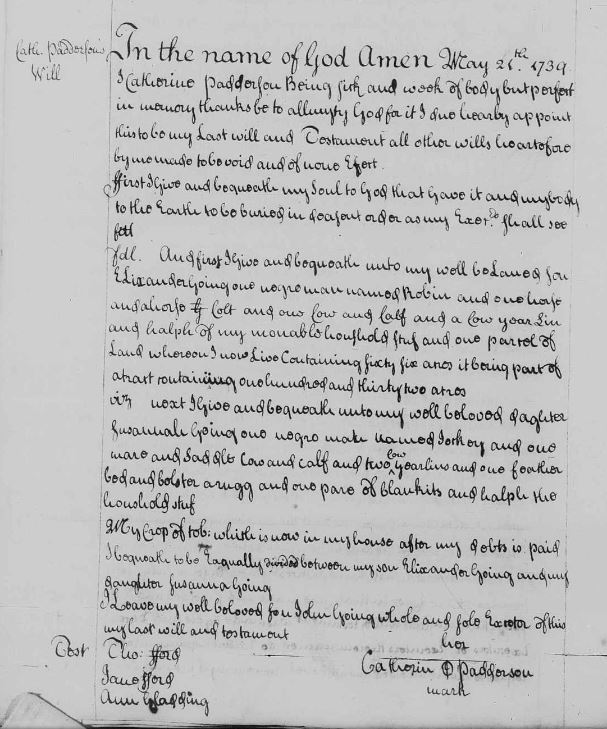
1739 May 21 (written); 1739 July 23 (probated) – Last Will and Testament of Catherine Padderson
In the name of God amen, May 21 1739 I Catherine Padderson being sick and weak of body but perfect in memory thanks be to allmighty God for it. I do hereby appoint this to be my Last Will and Testament all other wills heretofore by me made to be void and of none effect.
– First, I give and bequeath my soul to God that gave it and my body to the Earch to be buried in decent order as my executors shall see fit.
– Viz, And first I give and bequeath unto my well beloved son Elixander Going one negro man named Robin and one horse and a horse colt and one cow and calf and a cow yearling and halph of my movable houshold stuf and one parcel of land whereon I now live containing 66 acres, it being part of a tract containing 132 acres.
– Viz, next I give and bequeath unto my well beloved daughter Susannah Going one negro man named Jackey and one mare and saddle, cow and calf and two cow yearlings and one feather bed and bolster, a rugg and one pare of blankits and half the household stuf.
– My crop of tob: which is now in my house after my debts is paid I bequeath to be equally divided between my son Elixander Going and my daughter Susannah Going.
– I leave my well beloved son John Going whole and sole executor of this my last will and testament.
Signed: Catherin Padderson (mark)
Wits: Thomas Ford, Jane Ford, Ann Gladding
Will Bk C, p 180. Prince William Co, Va.
https://www.familysearch.org/ark:/61903/3:1:3QS7-L9PX-FQ2Y?i=100&cat=379047
1739 Last Will and Testament of Catherine Padderson in PW Co Va. Will bk C, p 180
1739 July 23 – (Certificate of Administration of Catherine Padderson decd’s Estate granted John Going)
At a Court held for Prince William County July 23d 1739.
This will was presented in Court by John Going sole executor herein named who prayed certificate for obtaining a probate thereof but it being suggested that the decd’s husband is living on the motion of the said John Going & giving security for his just & faithfull administration of the said decd’s Estate certificate was granted him for obtaining letters of Administration with the will annexed in due form.
Test: Catesby Cocke, ClCur.
Will Bk C, p 181. Prince William Co, Va.
https://www.familysearch.org/ark:/61903/3:1:3QS7-L9PX-FQ2Y?i=100&cat=379047
1739 July 23 – (Bond) Know all men by these presents that we John Going, William Scutt & John Hollis are held and firmly bound unto Denis McCarty Gent the first Justice in the comission of the Peace for Prince William County for and in behalf & to the sole use & behoof of the Justices of the said County & their successors in the sum of 100 pounds to be paid to the said Denis McCarty his exrs… & assigns … which payment will and truly to be made we bind ourselves & every of us our & every of our heirs exrs& assgns jointly & severally firmly by these presents. Sealed with our seals dated this 23 day of July 1739.
The condition of this obligation is such that if the above bounden John Going Admr with the will annexed of the goods chattels and credits of Catherine Padderson decd do make or cause to be made a true and perfect Inventory of all & singuar the goods chattels and credits of the said deceased which have or shall come to the hands possession or knowledge of the said John Going or into the hands or possession of any other person or persons for him and the same so made do exhibit or cause to be exhibited into the County Court of Prince William at such times as he shall be thereunto required by the said Court and the same Goods Chattels & Credits & all other the the Goods Chattels & Credits of the said decd at the time of her death which at any time after shall come to the hands or possession of the said John Going or into the hands or possession of any other person or persons for him do well & truly administer according to law and further do make a just & true account of his actings & doings therein when thereto required by the said Court and also do well & truly pay & deliver all the Legacys contained & specified in the said Testament as far as the said Goods Chattels & Credits will thereunto extend according to the value thereof & the law shall charge then this oblication to be voide otherwise to remain in ful force and virtue.
Signed: John Going, John Hollis, William Scutt
Wit: John Bowie
At a Court held for Prince Wiliam County July 23 1739 John Going, John Hollis & William Scutt acknowledged this bond to be their act & deed and it was thereupon ordered to be recorded.
Test: Catesby Cocke, ClCur
Will Bk C, p 181-182. Prince William Co, Va.
https://www.familysearch.org/ark:/61903/3:1:3QS7-L9PX-FQ2Y?i=100&cat=379047

1739 Catherine Padderson decd est admin orders & bond PW Co Va bk C p 181
 1739 July 23 bond for Catherine Padderson decds estate in PW Co Va. Will Bk C, p 182
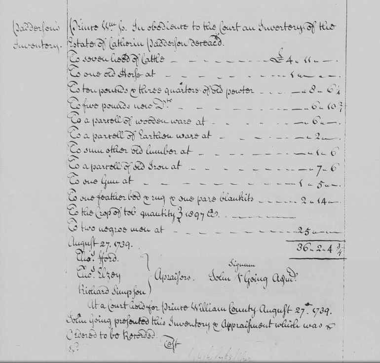
1739 Aug 27 Prince William County. In obedience to the Court an Inventory of the Estate of Catherin Padderson decd.
To 7 head of cattle – 4.11.0
To one old horse at – 1.0.0
To 10 pounds & 3 quarters of old pewter – 0.8.6
To 5 pounds new Do. – 0.6.10
To a parcell of wooden ware at – 0.6.0
To a parcell of earthen ware at – 0.2.0
To sum other old lumber at – 0.1.6
To a parcell of old iron at – 0.7.6
To one Gun at – 1.5.0
To one feather bed & rug & one pare blankits – 2.14.0
To the crop of tob. quantity 1897
To two negroe men at – 25.0.0
August 27, 1739 – (Total) – 36.2.4 and 3/4
Thomas Ford, Thomas Elzey, Richard Simpson – Apraisers
Signed: John Going admin
At a Court held for Prince William County August 27, 1739.
John Going presented this Inventory & Appraisement which was ordered to be recorded.
Test: Catesby Cocke, ClCur
Will Bk C, p 188. Prince William Co, Va.
https://www.familysearch.org/ark:/61903/3:1:3QS7-L9PX-FQ2Y?i=100&cat=379047
1739 Inventory for Catherine Padderson decd estate in PW Co Va. Will Bk C p 188
1739 Nov 26 – Catherine Padderson’s Addtl Inventory
Prince William County November 26, 1739. To the Worshipful Court an additional Inventory of the Estate of Catherine Padderson decd viz:
To one Mare at – 1.0.0
To one old Rund Lett(?) – 0.1.0
(Total): 1.1.0
Thomas Ford, Thomas Elzey, Richard Simson – Appraisers
Signed: John Going
At a Court held for Prince William County November 26, 1739. John Going returned this Additional Inventory & Appraisement which was ordered to be recorded. Test: Catesby Cocke, ClCur
Will Bk C, p 195. Prince William Co, Va.
https://www.familysearch.org/ark:/61903/3:1:3QS7-L9PX-FQ5X?i=107&cat=379047

1739 Addtl Inventory for Catherine Padderson decd Estate. PW Co Va. Will bk C, p 195
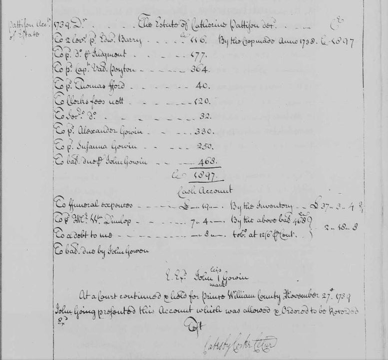
1739 Nov 27 – Catherine Pattison Acct of Estate 1739.
The Estate of Catherine Pattison decd.
pd Edward Barry – 116 [Truro Parish clerk]
pd Judgment – 177
pd Capt Valentine Payton – 364
pd Thomas Ford – 40
pd Clerks fees – 120
pd Service? fees – 32
pd Alexander Gowin – 330
pd Susanna Gowin – 250
pd John Gowin – 468
By the crop made Anno 1738 – 1897
(Total): 1897
Cash Account
To funeral expenses – 0.19.0
pd Mr William Dunlop – 7.4.0
To a debt to me – 0.8.0
by the inventory 37.3.4 and 3/4
by the above bal 468 tob at 12/6 pcent – 2.18.8
To bal due by John Gowen
Signed: John Gowin
At a Court continued & held for Prince William County November 27, 1739 John Going presented this account which was allowed & ordered to be recorded.
Test: Catesby Cocke, ClCur
Will Bk C, p 199. Prince William Co, Va.
https://www.familysearch.org/ark:/61903/3:1:3QS7-L9PX-FQ2N?i=109&cat=379047
1739 Account for Catherine Padderson decd Estate in PW Co Va. Will bk C, p 199
WILLIAM GOING’S CHILDREN IN PRINCE WILLIAM/FAIRFAX AREA AFTER HIS DEATH:
1739 – Prince William County, Virginia Wills, Part 2, 1734-1920
Given Name: John
Surname: Goings
Year: 1739
Inheritance Tax/Book: C
Inheritance Tax Page #: 181
Ancestry.com. Prince William County, Virginia Wills, Part 2, 1734-1920 [database on-line]. Provo, UT, USA: Ancestry.com Operations Inc, 1999.
https://search.ancestry.com/cgi-bin/sse.dll?indiv=1&dbid=3898&h=1580&tid=&pid=&usePUB=true&_phsrc=kUu4551&_phstart=successSource
1741 Sept 1 – John Going Col. Gooch
1742 Oct 4 – Discharged from Goochs Marines – Cumberland Muster Book – Col Goochs Regiment. Va. Militia
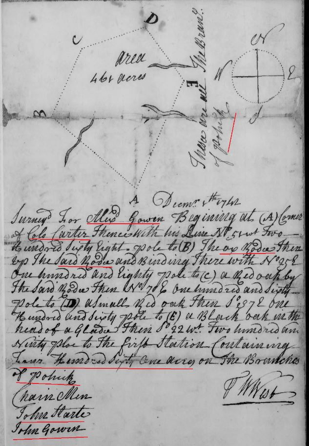
(Note: The following survey was done for Alexander Gowin in 1742, but he did not obtain the actual grant until 1768. Alexander moved to Orange County, North Carolina by around 1753/54. It is unknown why he did not obtain his actual grant for 26 years).
1742 April 16 (Warrant)- To Mr. William West. Whereas William Dowling of the County of Prince William hath informed that there are about 500 acres of waste and ungranted lands in the sd County on the Branches of Pohick joyning on the land of Lewis Elsey …. and desiring to have a survey thereof in order to have a deed…. These are to empower you the said William West to make a true and just and accurate survey of the said waste lands provided …. a return whereof with this warrant you are to give into the office any time before the 25th day of Dec next ensuing. Given under my hand … this 16th day of Aprill 1742. W. Fairfax.
1742 Nov. 30th (Warrant Note) – If the within named William Duling refuses to have the warrant for the land therein exprest, executed for him, then you may survey it for Alexander Gowin. Given under my Hand this 30th November 1742. W. Fairfax… To: Mr. Wm. West.
Note: Wm. Dowling refuses to have this warrt. I have executed it for Alexander Gowen.
1742 Dec 8th – Surveyd for Alexander Gowin December 8th 1742 beginning at a (A) corner of Colo. Carter thence with his line N.5 degrees west 268 poles to (B) the Ox Rode then up the said Rode and binding therewith N. 25 degrees E 180 pole to (C) a red oak by the said Rode then N. 70 degrees E 160 pole to (D) a small red oak then S 37 degrees E 160 pole to (E) a black oak in the head of a glade then S 22 degrees W 290 pole to the first station containing 461 acres on the Branches of Pohick. Signed: W. West. Chainmen: John Stark, John Gowin.
http://image.lva.virginia.gov/LONN/NN-1/213/0381_0384.pdf
1742 Oct 13 – John Gowin survey was done on Oct 13, 1742 for 155 acres in Fairfax Co Va – … survey for John Gowin Oct 13, 1742 … corner of Thomas Ford … with Ford’s lines … on the main branch of Popeshead … corner of Capt Connier’s … containing 155 acres. Chainmen listed as: John Stark, Alexander Gowin. Surveyor signed: W West. Fairfax Co, Va.
http://image.lva.virginia.gov/LONN/NN-1/213/0385_0388.pdf

1742 Oct 13 John Gowin survey for 155 acres in Fairfax Co Va_Page_3 marked snip
1742 Oct 30 – John Gowen had this survey Oct 30, 1742 for 144 acres in Fairfax Co Va – described as … near a branch of The North Run of Pohick and Corner to Robert Carter Esqr … line of the widow Coster (sp?) … line of Richard Simpson … Chainmen: John Stark, Alexander Gowen. Pilitt: John Gowen. Surveyor: William West.
http://image.lva.virginia.gov/LONN/NN-1/213/0378_0380.pdf

1742 Oct 30 survey for John Gowen for 144 acres in Fairfax Co Va_Page_2 marked snip
1743 Feb 10 – Thomas Going buys a lease on land from Robert Bates in Fairfax County, Va. (Fairfax County, Va deed index). 1743 Feb 10th … between Robert Bates of Fairfax County, planter of the one part and Thomas Going of the same County planter of the other part … Robert Bates for and in consideration … of the said Thomas Going … to be paid due and performed … granted … to the said Thomas Going one meseuage plantation … tract of land whereon he now dwells containing 100 acres more or less being part of a larger tract of land granted to … is bounded as followeth beginning at the Rattle Snake Run … to Fitshughes line from thence to Wests so along Solomons tract to Harrisons line … to the said Thomas Going his heirs and assignes for and during the term of their natural lives of the said Thomas Going, Elizabeth Carrol daughter of William Carrol & Henry Bates son of the said Robert Bates and of the longest liver of them … .. on said tenement … to tend any part of the said land during the said tenment … of the said Thomas Going … paying to the said Robert Bates … six hundred and thirty pounds of tobacco yearly during such subtenants abode thereon over and above the yearly rent above mentioned … Signed: Robert Bates, Thomas Going. Wit: Margaret Territt, William Carol, William Henry Terrett. Filed in Fairfax County Court on Feb 16, 1743 by Robert Bates. Deed bk A1, p 101, Fairfax Co, Va
https://www.familysearch.org/ark:/61903/3:1:3Q9M-CS4V-BSFF-T?i=59&cat=202100
1743 Feb 4 – Lease. Robert Bates, of Fairfax Co, planter, and William Perkins, same Co. Named in boundaries Gabriel Adams, Alexander Scott, clerk Thomas Farmes (or Fanner), now Hugh Wests, along line of land leased by Robert Bates to Thomas Going, lease for the natural lives of the said William Perkins, Valentine Perkins his son & Sara Perkins his dau for life. Wit. Mary Terrett, Ann Pearson. 15 Mch 1755, p. 139.
https://www.familysearch.org/ark:/61903/3:1:3Q9M-CS4V-BSFH-6?i=79&cat=202100
1743 Nov 27 – William Elzey, son of Capt . Lewis Elzey, of Fairfax Co. 300 A. in Fairfax Co . Surv. Mr. William West. Adj. John Gowen, Col. Carter, on Ox Road, Bond Veal, Giles Tillet, Thomas Ford. 27 Nov . 1743. Northern Neck Grants F, 1742-1754, p. 144 (Reel 292). Fairfax Co., Va
https://lva.primo.exlibrisgroup.com/permalink/01LVA_INST/altrmk/alma990008525510205756
1744 July 6 – John Gowen of Fairfax Co. 155 A. in Fairfax Co. Surv. Mr. William West. Adj. Thomas Ford, main Br. of Pope’s Head, Capt. Connyer. Northern Neck Grants F, 1742-1754, p. 187 (Reel 292). Fairfax Co., Va
https://lva.primo.exlibrisgroup.com/permalink/01LVA_INST/altrmk/alma990008537220205756
1744 July 10 – John Gowen of Fairfax Co . 144 A. in said Co. Surv. Mr. William West. Near Pohick, adj. Robert Carter Esq, Wid. Coffer, Richard Simpson. Northern Neck Grants F, 1742-1754, p. 191 (Reel 292). Fairfax Co, Va
https://lva.primo.exlibrisgroup.com/permalink/01LVA_INST/altrmk/alma990008537230205756
1744 March 5 – John Goen and wife Mary to Thomas Ford, Fairfax Co, Va
Lease: … between John Goen of the Parish of Truro in the County of Fairfax and Mary his wife of the one part and Thomas Ford of the parish and county aforesaid of the other part… John Goen and Mary his wife … sell unto the said Thomas Ford two certain parcels of Land one tract or parcel of land containing 56 acres the same more or less situate and being in the Parish and County aforesaid on the E side of Popes Head Run and bounded … in the Fork of the Rattle Snake Branch … part of a greater tract of land containing 112 acres granted to William Goen dec’d father to the said John Goen … deed from the proprietors office bearing date the 12th day of November 1725 … and also another tract or parcel of land containing by estimation 44 acres being part of a greater tract of land containing 155 acres situate … in the County of Fairfax aforesaid on Popes Head Run between Thomas Fords two former tracts of land and a tract of land formerly granted to David Waugh and bounded … on the main run’s corner to the said Thomas Ford thence along the said Fords line … to another corner of the said Ford … to the main run of Popes Head … on each side of the said run … the same being granted to John Goen by deed from the Proprietors office dated 6th day of July 1744 …
Signed: John Goen, Mary Goen
Wit: William King, John Ford, Robert Lindsey, Richard Simpson Junr, Giles Tillet, Alexander Anderson
1744 Apr 16 – lease proved by oaths of Giles Tillett, William King, and Richard Simpson Junr …
1745 March 6 – Release: … between John Goen of the Parish of Truro in the County of Fairfax and Mary his wife of the one part and Thomas Ford of the Parish and County aforesaid of the other part … confirm unto the said Thomas Ford … two certain parcels of land, one tract containing 56 acres… (described above in Lease) … the other tract containing 44 acres … (described above) …
Signed: John Goen, Mary Goen
Wit: William King, John Ford, Robert Lindsey, Richard Simpson Junr, Giles Tillet, Alexander Anderson
1745 Apr 16 – release recorded.
https://www.familysearch.org/ark:/61903/3:1:3Q9M-CS4V-BSX5-7?i=189&cat=202100
1744 Mar 6 – John Goen & wife Mary to Thomas Ford, Release, Deed bk A1, p 351, Fairfax Co, Va
https://www.familysearch.org/ark:/61903/3:1:3Q9M-CS4V-BSF3-8?i=190&cat=202100
1746 June 9 – John Goen and wife Mary to Edward Kirkland, Lease & Release, Deed bk B1 p 32-39, Fairfax Co, Va
Lease p. 32: … between John Goen of the Parish of Truro in the County of Fairfax and Mary his wife of the one part & Edward Kirkland of the parish and County aforesaid of the other part … the said John Goen and Mary his wife … sell unto the said Edward Kirkland one half of a certain parcel of land a tract or parcel containing 268 acres of land situate lying in parish & County aforesaid on the North side of Ocaquan below the mouth of the North Fork of the said Run Ocaquan and bounded … upon the said riverside being the uppermost corner tree of a tract of land belonging to Richard Ridgewell … along the said Ridgewells line .. at the mouth of the said Run thence down the water course of the said river to the beginning … it being a tract of land granted to Richard Kirkland dec’d & Cornelias Keeif father to the said Goens wife party to these presents by deed from the proprietors office bearing date the 23 day of November 1714 … & from the said Cornelias Keeif him his heirs … the half of the said parcel or tract of land aforementioned which the said Edward Kirkland is at this present possess …
Signed: John Gowen, Mary Gowen
Wit: John Bayless, William King, Bond Veale
1746 Aug 19 – At a Court held for Fairfax County .. this lease from John Goen & Mary Goen to Edward Kirkland was proved by the oaths of John Bayless, William King, and Bond Veale to be their act & Deed & admitted to record.
https://www.familysearch.org/ark:/61903/3:1:3Q9M-CS4V-BSXH-D?i=375&cat=202100
1746 June 10 – John Goen and wife Mary to Edward Kirkland, Release, Deed bk B1, p 35, Fairfax Co, Va
Release p. 35: … between John Goen of the Parish of Truro in the County of Fairfax and Mary his wife of the one part & Edward Kirkland of the parish and County aforesaid of the other part … confirm unto the said Edward Kirkland … one half of a certain parcel of land a tract parcel containing 268 acres … (description above in lease) …
Signed: John Gowen, Mary Gowen
Wit: John Bayless, William King, Bond Veale
1746 Aug 19 – At a court held for Fairfax County … this release from John Goen and Mary Goen to Edward Kirkland was proved by the oaths of John Bayless, William King & Bond Veale to be their act & Deed & admitted to record.
https://www.familysearch.org/ark:/61903/3:1:3Q9M-CS4V-BSX4-W?i=376&cat=202100
See the following original grant to Cornelius Keeif:
1713 Sept 4 – Cornelius Keiffe and Richard Kirkland receive 268 acres. On the North side of Occoquan River. Adj to Richard Ridgewell. Stafford County, Va. (Father of Mary Keith Gowing and Father in Law of John Gowing Sr). Northern Neck Grants No. 5, 1713-1719, p. 6 (Reel 289). https://lva.primo.exlibrisgroup.com/permalink/01LVA_INST/altrmk/alma990008562300205756 1714 Nov 23, Cornelius Keeiffe (Keith) and Richard Kirkland receive a grant for 268 acres on the North side of the Occoquan River, adj to Rd. Ridgewell (Cornelius Keeiffe is the father of Mary Keith, wife of John Gowing Sr). Northern Neck Grants No. 5, 1713-1719, p. 6 (Reel 289). https://lva.primo.exlibrisgroup.com/permalink/01LVA_INST/altrmk/alma990008559580205756
These 268 acres granted to Cornelius Keeiffe and Richard Kirkland are found on the following map (click to enlarge):

Fairfax Co landowner Southern section marked
Note: Some time in the mid to late 1720s, Cornelius Keiffe/Keith’s daughter Mary was married to John Going/Gowen.
1746 July 14 Lease: – John Gowen to Bond Veale, Lease & Release, Deed bk B1, p 24-29, Fairfax Co, Va
Lease p. 24: … between John Gowen of Truro Parish and the County of Fairfax planter of the one part & Bond Veale of the aforesaid Parish & County planter of the other part … the said John Gowen … doth bargain and sell unto the aforesaid Bond Veale … all that parcel of land containing by estimation 144 acres … which was granted to the said John Gowen by deed from the Proprietors office bearing date the 10th day of July 1744 … in the Parish and County aforesaid and bounded … near a branch of the North Run of Pohick and corner to Robert Carter Esqr thence with his line … in the line of the Widow Coffer … to the line of Richard Simpson …
Signed: John Gowen
Wit: William Grove, George Duren, John Duren.
1746 July 15 – John Gowen acknowledged this lease to Bond Veale to be his act and Deed which is admitted to record.
https://www.familysearch.org/ark:/61903/3:1:3Q9M-CS4V-BSXH-2?i=371&cat=202100
1746 July 15 – John Gowen to Bond Veale, Release, Deed bk B1, p 26, Fairfax Co, Va
Release p. 26: … between John Gowen of Truro Parish and the County of Fairfax planter of the one part & Bond Veale of the aforesaid Parish & County planter of the other part … John Gowen … doth fully acquit & discharge the said Bond Veale … confirm unto the said Bond Veale … land containing by estimation 144 acres … granted to the said John Gowen by deed from the proprietors office bearing the date the 10th day of July 1744 … (described in lease above) …
Signed: John Gowen
Wit: William Grove, George Duren, John Duren.
1746 July 15 – John Gowen acknowledged this release to Bond Veale to be his act and deed and Mary the wife of the said Gowen being privatly examined relinquished her right of Dower to the land by the said release …
https://www.familysearch.org/ark:/61903/3:1:3Q9M-CS4V-BSXZ-K?i=372&cat=202100
http://www.fairfaxcounty.gov/courts/circuit/pdf/deed-book-index-1742-1797.pdf
1747 Aug 17 – Alexander Gowen to Bond Veale, Lease & Release, Deed bk B1, p 253, Fairfax Co, Va
Lease:… between Alexander Gowen of Truro Parish and County of Fairfax planter of the one part and Bond Veale of the aforesaid Parish and County planter of the other part … Alexander Gowen …. sell unto the aforesaid Bond Veale …. land containing by estimation 56 acres … in the Parish of Truro and County of Fairfax … at the Division Line made mention of in Thomas Ford’s Deed of Sale bought of John Gowen …
Signed: Alexander Gowen.
Wit: Joseph Cockerill, Joseph Gardner, John Melton
1747 Aug 18 – Release: … between Alexander Gowen of Truro Parish and County of Fairfax planter of the one part and Bond Veale of the aforesaid Parish and County planter of the other part … Alexander Gowen … confirm unto the said Bond Veal … land containing by estimation 56 acres … situated … in the Parish of Truro and County of Fairfax … at the Division Lines made mention of in Thomas Ford’s deed of sale bought of John Gowen …
Signed: Alexander Gowen
Wit: Joseph Cockerill, Joseph Gardner, John Melton
Recorded Aug 18, 1747 by oath of Alexander Gowen and motion of Bond Veale.
https://www.familysearch.org/ark:/61903/3:1:3Q9M-CS4V-BS6P-F?i=505&cat=202100
See William Gowing’s grant and survey for 112 acres:
1725 Nov 12 – A-171: William Gowing of Stafford Co 112a in said Co on Rattlesnake Br of Popeshead Run. 12 Nov 1725. p. 82. Grant No. 131 according to “Grants by the Proprietors of the Northern Neck of Virginia.” “William Goings” receives Grant No. 131 November 12, 1725 for 112 acres “on Rattlesnake Branch of Popeshead,” according to “Grants by the Proprietors of the Northern Neck of Virginia.”
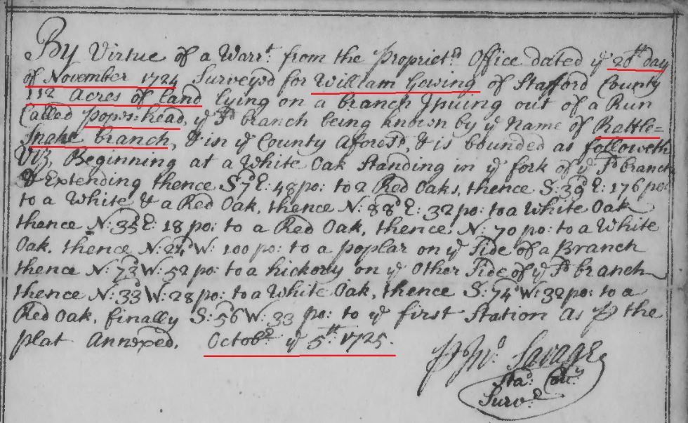
1725 Oct 5 survey of William Gowing for 112 acres in Stafford Co, Va snip 1

1725 Oct 5 survey of William Gowing for 112 acres in Stafford Co, Va snip 2
Link to survey: http://image.lva.virginia.gov/LONN/NN-1/240/0148_0150.pdf
1749 June 20 – The Petition of ALEXANDER GOING against JOSEPH WILLIAMS is dismist.
Fairfax County Court Order Book, 1749-1754 p. 17.
https://www.familysearch.org/ark:/61903/3:1:3Q9M-CS4V-B9Y6-Z?i=18&cat=193222
1749 Sept 30 – On the Petition of WILLIAM HICKS Esq. against ALEXANDER GOING Judgment is granted the Petitioner against the said Defendant for Six hundred and twenty eight pounds of Tobacco and four Shillings and Six pence current money by note of hand and Costs. Fairfax County Court Order Book, 1749-1754 p. 43.
https://www.familysearch.org/ark:/61903/3:1:3Q9M-CS4V-B9B9-B?i=31&cat=193222
1751 Mar 30 – Court held March 30, 1751. On the petition of John Milstead against Alexander Gowen, John Summers William Berckley and John Ward or any two of them are Ordered to view and Value the work done by the petitioner for the Defendant and report the Value thereof to the next court. Fairfax County, VA; Fairfax County Court Order Book, 1749-1754 p. 151, http://files.usgwarchives.net/va/fairfax/court/etal554gwl.txt , https://www.familysearch.org/ark:/61903/3:1:3Q9M-CS4V-B9TR-J?i=104&cat=193222
(see other orders on same day regarding Alexander Gowen and Moses Hollis – out of same case):
1751 Mar 30 – Court held March 30, 1751. Joseph Bayloy au Evidence for John Milstead against Alexander Gowen having attended seven Days Ordered he to pay him for the same according to Law. Fairfax County, VA; Fairfax County Court Order Book, 1749-1754 p. 151, http://files.usgwarchives.net/va/fairfax/court/etal554gwl.txt, https://www.familysearch.org/ark:/61903/3:1:3Q9M-CS4V-B9TR-J?i=104&cat=193222
1751 Mar 30 – Court held March 30, 1751. Moses Holles au Endowed for John Milstead against Alexander Gowen having attended seven days ordered that he to pay him for the same according to law. Fairfax County, VA; Fairfax County Court Order Book, 1749-1754 p. 151, http://files.usgwarchives.net/va/fairfax/court/etal554gwl.txt
https://www.familysearch.org/ark:/61903/3:1:3Q9M-CS4V-B9TR-J?i=104&cat=193222
1751 Mar 30 – Court held March 30, 1751. Moses Hollis au Evidence for Jane Purcel against Joseph Stevens and Alexander Gowen having attended Seven Days Ordered. She to pay him for the same according to Law. Fairfax County, VA; Fairfax County Court Order Book, 1749-1754 p. 151, http://files.usgwarchives.net/va/fairfax/court/etal554gwl.txt
https://www.familysearch.org/ark:/61903/3:1:3Q9M-CS4V-B9TR-J?i=104&cat=193222
1751 Mar 30 – Court held March 30, 1751. John Simpson au Evidence for Jane Purcel against Joseph Stevens and Alexander Gowen having attended Seven Days Ordered. She to pay him for the same according to Law and coming and returning twice thirty Miles. Fairfax County, VA; Fairfax County Court Order Book, 1749-1754 p. 151, http://files.usgwarchives.net/va/fairfax/court/etal554gwl.txt
https://www.familysearch.org/ark:/61903/3:1:3Q9M-CS4V-B9TR-J?i=104&cat=193222
1751 Mar 30 – Court held March 30, 1751. Thomas Remy au Evidence for Jane Purcel against Joseph Stevens and Alexander Gowen having attended Seven Days Ordered. She to pay him for the same according to Law and coming and returning twice thirty Miles. Fairfax County, VA; Fairfax County Court Order Book, 1749-1754 p. 151, http://files.usgwarchives.net/va/fairfax/court/etal554gwl.txt
https://www.familysearch.org/ark:/61903/3:1:3Q9M-CS4V-B9TR-J?i=104&cat=193222
1751 Sept 26 – On the petition of John Milstead against Alexander Gowen judgment is granted the petitioner against the said Defendant for two pounds ten shillings current money and his costs by him in this behalf expended according to the report of the referrees.
Fairfax County Court Order Book, 1749-1754 p. 169.
https://www.familysearch.org/ark:/61903/3:1:3Q9M-CS4V-B9TG-K?i=113&cat=193222
1754 Jan 18 – Richard Brown plt against Alexander Gowen deft} Trespass assault & Battery
This day came the afsd RIchard by William Ellzey his attorney & thereupon came a jury to wit John Dalton, Harry Pipe, John Kirkpatrick, Peter Stalker, James Robertson, William Bronaugh, William Waite, Denis McCarty, Walter Stuart, Thomas Wren, Thomas Sorrell & John Templeman who being sworn well & truly to inquire what damages the said Richard hath sustained by occasion of the said Alexander’s beating and wounding him upon their oath do say that the said Richard hath sustained damages by that occasion to one penny besides his costs. Therefore it is considered that the said Richard recover against the said Alexander his damages afsd amounting to one penny & his costs by him in this behalf expended & the said Alexander be taken.
Fairfax County, Va – Order book, 1749-1754. p. 520.
https://www.familysearch.org/ark:/61903/3:1:3Q9M-CS4V-B91W-G?i=290&cat=193222
1754 Nov 21 – John Pagan Plt against Moses Hollis Deft} Trespass on the Case.
This day came the Plt by George Johnston his attorney and Surles Lewis & Alexander Gowing the Defts common bail by their attorney come & defend the force & Injury when … say that the said Deft did not undertake in the manner & form as the said Plt hath complained against him and of this they put themselves upon the Country & the said Plt does likewise the same. Therefore the Sheriff is comanded that he cause to come here at the next Court 12 free and lawful men …
Fairfax County, Va – Order book, 1749-1754. p. 176
https://www.familysearch.org/ark:/61903/3:1:3Q9M-CS4V-B9BX-1?i=393&cat=193222
1768 June 11 – 0-155: Alexander Gowen of North Carolina 461 A. on Pohick in Fairfax Co. Surv. William West. Adj . Col. Carter. 11 June 1768. p. 197. Land: grant 461 acres, 11 Jun 1768, , Fairfax, Virginia, USA. 461 acres of waste and ungranted land on the branches of Pohick surveyed by Wm West, and touching a corner of Col Carter’s land. Fairfax Co, Va.
https://www.familysearch.org/ark:/61903/3:1:3Q9M-CSRP-M4PF-S?i=170&cat=414338
(Note: See the following Survey from 1742. It appears that Alexander Gowen decided to finally get the grant some 26 years after having the original warrant and survey done. Alexander Gowen was living in Orange County, NC at the time. It appears he must have sold the land):
1742 April 16 (Warrant)- To Mr. William West. Whereas William Dowling of the County of Prince William hath informed that there are about 500 acres of waste and ungranted lands in the sd County on the Branches of Pohick joyning on the land of Lewis Elsey …. and desiring to have a survey thereof in order to have a deed…. These are to empower you the said William West to make a true and just and accurate survey of the said waste lands provided …. a return whereof with this warrant you are to give into the office any time before the 25th day of Dec next ensuing. Given under my hand … this 16th day of Aprill 1742. W. Fairfax.
1742 Nov. 30th (Warrant Note) – If the within named William Duling refuses to have the warrant for the land therein exprest, executed for him, then you may survey it for Alexander Gowin. Given under my Hand this 30th November 1742. W. Fairfax… To: Mr. Wm. West.
Note: Wm. Dowling refuses to have this warrt. I have executed it for Alexander Gowen.
1742 Dec 8th – Surveyd for Alexander Gowin December 8th 1742 beginning at a (A) corner of Colo. Carter thence with his line N.5 degrees west 268 poles to (B) the Ox Rode then up the said Rode and binding therewith N. 25 degrees E 180 pole to (C) a red oak by the said Rode then N. 70 degrees E 160 pole to (D) a small red oak then S 37 degrees E 160 pole to (E) a black oak in the head of a glade then S 22 degrees W 290 pole to the first station containing 461 acres on the Branches of Pohick. Signed: W. West. Chainmen: John Stark, John Gowin.
http://image.lva.virginia.gov/LONN/NN-1/213/0381_0384.pdf
(Note: Only the index is available – Book N is missing – but it appears that eithere Alexander Gowen sold the above land prior to his decease in 1774/75 – and it was not recorded until after 1776 … or his estate sold the land to Richard Skinner some time between 1776-1784).
1776-1784 (likely when recorded) – Alexander Gowen to Richard Skinner, Deed bk N1, p 217, Fairfax Co, Va (Deed bk N1 is missing)
https://www.fairfaxcounty.gov/circuit/sites/circuit/files/assets/documents/pdf/hrc/deed-book-index-1742-1866-f-k.pdf
1776-1784 (likely when recorded) Alexander Gowen to Richard Skinner, Deed bk N1, p 218, Fairfax Co, Va (Deed bk N1 is missing)
https://www.fairfaxcounty.gov/circuit/sites/circuit/files/assets/documents/pdf/hrc/deed-book-index-1742-1866-f-k.pdf
John Going and his family move to Lunenburg County, Virginia by 1748, and then later moved to Orange County, North Carolina. See:
- 1700 John Going Sr married to Mary Keith (Y2)
- Virginia – Lunenburg County – 1700s to early 1800s
- North Carolina – Orange County
Alexander Going and his family moves to Orange County, North Carolina by 1753. See:
It is unknown what happened to Ambrose Going or Susannah Going or if and when they may have moved from the Fairfax County, Virginia area.
HOWSON PATENT LITIGATION
HOWSON PATENT LITIGATION:
SURVEY OF HOWSON PATENT DONE IN 1767 DURING CARLYLE v ALEXANDER CASE
1767 Jan 1 – (Survey) John Carlyle v Alexander – disputed survey on Howson Patent. Fairfax Co, Va
In obience on a order of the worshipful Court of Fairfax dated 1st January 1767 I the subscriber did proceed to survey the land in dispute … The way the … laid off Thomas & Todd’s patent and which he claims is represented by the following letters x y z aa bb pp & thence up Four Mile Run to the beginning.
The way the Pltf has laid off the Defendant’s tract, taken up by having is represented as follows. Beginning at A thence down Potomack … the several meanders thereof including Hamton’s Creek, Four Mile Creek, & Ralph’s Gut, as the black dotted lines across these waters will appear; and so down the said meanders to B at the mouth of Great Fishing Creek; which, reduced to a direct? line, is S9 and 3/4 E 2198 poles. Thence up the meanders of the Hunting Creek and by the black dotted lines; which, reduced to a direct line is N 58 W 517 poles to C in the field of John West Jr. Thence near an ancient marked line, as … the plat, N 3 degrees 10 m W 1940 poles to D. Thence S78E 179 poles to the beginning at A; Which includes 5995 acres, 3 Rood, & 18 Perches.
The Pltf required me to go to the Hickory Bush at C and from thence to run a line N6W (near a line of ancient marked trees, as .. the plat which said line … N 7 and 3/4 W) 1940 poles to E. Thence from E S87E 345 poles to A the beginning. The quantity of land included between the N7 and 3/4West line, & the River is 7117 acres, 1 Rood, & 28 perches.
The Pltf required me to lay off Owsley’s patent as is represented by the letters ii kk ll mm. At the Pltfs request I have laid down Howsen’s Patent as it was adjudged in the General Court October 1758 in the suit Ramssay v Alexander, which is my newly represented in this plat by the letters A B C F.
The defendant’s survey for Howsens Patent under which he claims is represented by the letters A B C D from A to B is mentioned before in the pltfs survey; from B to C is N60 and 1/2 W 523 poles. From C to D is N10W 1975 poles near a line of ancient marked trees a in the plat.
From D to A is N87 and 1/2E 691 poles, which includes 9197 acres 1 rod 15 poles.
The Defendant required me to survey Stephen Gray’s patent for 370 acres which is represented by the letters cc dd ee ff gg hh & the meanders of Four Mile Run to the beginning.
I ran only the two first courses of this deed, when the Defendant desired me to lay down the remaining one. The Defendant required me to lay off William Strutfields patent for 534 acres, which is represented by a b c d e f g h i k. I only ran the two first courses of this Deed, the Deft having requested me to plat down the other courses.
The Deft required me to survey William Strutfield’s patent for 500 acres, which I did, and is represented by the letters ii, nn, oo, A. and up the river to the beginning. The Deft required me to survey Awbrey’s patent for 1261 acres, which is represented by l m a n o p q r s t u v w & thence to the beginning. I ran only the lines rs, st, tu, uv, vw, & wl, the remaining courses plotted at the Defts desire.
Note, where any disputes have arose on this survey between the Pltf and Deft I refer to my explanatory notes or table, and also to the particular entries made by each party. Which said entries I have copied in their own word. I have never had the deposition in my custody which are rqferred to, & therefore cannot be more particular.
Signed: George West, SFC
))))))))))))))))))
Figures: A Table to explain the Plat
1. a post of Chubb’s Mill
2. the place shewn by Charles Gfiffith, Charity Nodson & John Summers, where Chub & Lylard formerly lived, as tenants to Robert Alexander, grandfather to the Defendant
3. The place shewn by Owen Morris, Charles Griffith & Charity Nodson, where another of the said Robert Alexander’s tenants lived.
4. The place by Owen Morris his house, shewn by John Summers, Morris & Ball, where Edward Chub formerly lived & kept a Mill as tenant to Robert Alexander.
5. represents a Corn Field.
6. a poplar anciently marked with two chops nearly on the North side.
7. a red oak anciently marked as a fore & aft line tree
8. The place admitted by Mr Sebastian the Pltfs attorney, where William Griffeth formerly lived, as tenant to Robert Alexander.
9. George Boucher’s house a tenant to Robert Alexander.
10. The place shewn by Bumson? and Wheeler where formerly stood a tree near the Wankopin Branch as beginning of Alexander, see his deposition.
11. A red a black oak anciently marked as a corner, said by the Pltf to be corner to Baldwin Dade.
12. a hickory saplin anciently marked as a line between an ancient marked red oak & hickory, particularly noticed at the request of the Defendant by Philip Alexander.
13. a hickory saplin in a Valley also particularly noticed by him.
14. John Alexanders fences on which plantation this ejectment was served, which is admitted by the Defendant.
15. a wheat field laid down now in possession of John ___ (smudged), formerly owned by John M?_____ (smudged) tenant to Gerard Alexander by virtue of a ? granted to Robert Mills noticed at the Defendants request.
16. a large rock stone, noticed at the Plaintiffs request.
17. a poplar, standing between two springs, in the Deposition of Wheeler & Greenwood
18. A poplar stump standing about 12 yards from the bank of the River and near a small Gut with a bank across it.
19. an apple tree in the edge of the River bank, several of its roots washed bare, see Boylstone’s deposition
20. an apple tree on Pearson’s Island, washed down; see Bowling’s deposition.
21. a Walnut tree in the depositions of Bowling, Moxley & Rose.
22. a white ___ standing on the shore, see the depositions of Bowling & Moxley.
23. Mr Townshend Dade’s house laid down
24. Mr Robert Alexander’s house laid down.
25. Messrs Carlyle & Dalton Smith’s shop under the bank
26. the Town Warehouse & Point Lumley
27. John Alexander’s Overseer’s house
28. A point commonly called Gladding’s Fishing Point
29. The Sloop Point commonly so called.
30. The point of John West Jr his pacoson.
31. a Gut or Inlet noticed at the Defendant’s request, see the deposition of Greenwood.
32. a Spring called the Riverside Spring noticed at the Defendants request, see the Depositions of Bowling, Osborn, Talbot & Rose.
33. A white oak said by the Defendant to be anciently marked with one plain chop of an ax & one other not plain, see the depositions of Bowling, Osborn Talbot, John Talbot, Greenwood & Morris. The Pltf objects to this being a line tree, it not being marked as such.
34. another white oak referred by the Defendant to the depositions of Sampson Darnell, Bowling?, Morris, Greenwood, Backeran, & Spinks, to be anciently marked with 2 chops of an ax on the SE side.
35. a red oake anciently marked nearly on the North side with 2 chops, & also marked nearly on SW side with 2 chops; noticed at the Defendants request.
36. 3 white oaks standing by the side of a pond shewn by the Plaintiff as corner to James Robertson’s patent, and the beginning of James Brechen’s patent.
37. (skipped from 36 to 38 it appears – possibly skipped in transcription into the book)
38. a poplar anciently marked nearly on the North side with 3 chops, and on the SW side, Barke is chiefly defaced, which Mr Sebastian says was done by Lawyers for Blacking. The Defendant refers to the depositions of Greenwood & Bowling to be marked on the N, S, & E sides. The figures 36, 37, 39 & lines dotted there ….. represent the courses of Robertson’s patent, as I surveyed by direction of the Pltf.
39. Three Spanish Oaks, one of which is marked with 3 chops on the N, E & SW sides.
40. Two red oak saplins from one root, lately marked GM, supposes by John Hough.
41. a line of James Green’s Fence
42. James Green’s house
43. The edge of William Ready’s tobacco ground, a tenant to Mr Ramsay.
44. the plantation laid down of John Alexander, where this ejectment was served, admitted by the Defendant to be within the bounds of the Plaintiff’s land as now surveyed.
45. William Butsell’s house laid down at the Defendant’s request, lately recovered by James Robertson from Robert Alexander.
46. a Gum Tree
47. Mr Ramsay’s quarter fence.
48. a small field of Mr Ramsays
49. a red oak stump referred by the Defendant to Owen Morris his deposition
50. a white oak cut down as a timber tree, noticed at the Defendant’s request by P Alexander; and also that about this place several trees are cut down.
51. another white oak stump also noticed by P. A. in behalf of the Defendant
52. a place where P. A. desired me to notice that several trees were cut down.
53. a dead hickory in an open piece of ground anciently marked on the W side with two chops, the same tree is lately marked was a fore & aft line tree by the Plaintiff’s order to prevent his people from cutting it down, noticed by P. A.
54. a hickory stump in the Pltfs field, see Owen Morris’ deposition
55. at this place P. A. desired me to note that John Williams his plantation is on the left hand a tenant to Alexander; see depositions of Bowling, Osborn Talbot, & Greenwood
56. a field of the Plaintiff noticed by the Defendant.
57. a white oak stump particularly noticed by ____ (smudged at top left of page)
58. (smudged at top left of page) ___ noticed by P. A.
59. a charred oak? anciently marked with two chops of an ax nearly on a level on one side, not above on request … by P A to the depositions of Morris & Bowling.
60. these trees suposed to be marked for line of Simmons lease, admitted by Sebastian
61. a chesnut oak at Dade’s? or upper long ? anciently marked as a line, see Ball, Morris & Hardrey’s depositions.
62. a white ___ anciently marked as a line tree.
63. a white oak anciently marked as a side line tree.
64. a white oak anciently marked as a corner
65. an ancient marked Beach; which the Defendant says is corner ___; see Osborn Talbot & Greenwood’s depositions.
66. a small Spanish Oak said by Sebastian to be marked as a line; which P Alexander denies.
67. a red oak said by some to be marked with 2 chops with an ax on the North side, on the S side bark is off, noticed by P Alexander; see O Talbot, William Thomas, & William Bowling’s depositions
)))))))))))
A – a red oak marked IA the beginning of Howson’s Patent at Wankopin Branch.
B – the mouth of Hunting Creek, the supposed second corner of Howson (no tree standing)
C – the place where the Plaintiff supposed Howson’s third corner stood, in John Wests field.
D – a white oak anciently marked, see the Depositions of Ball, Morris, Bowling, Summers, Greenwood, Gustowns?, Darrell & Boylstone.
E – The end of 1940 poles, no corner found.
F – the place where the fourth corner of Howsen’s patent should be, by the judgment of the General Court, in October 1758.
C – A hickory bush near the creek, at first admitted by the Pltff to be the third corner of Howsen’s patent, & afterwards denied by him to be so, for that C is Howsen’s third corner as he says.
D – near a stake in Jennings his field, supposed by the Defendant to be Howsen’s fourth corner
a – Two Lornn(sp?) Poplars on Four Mile Run Strutfield’s beginning,
x – and ancient marked hickory & red oak;
j – begin j of Thomas & Todd; see the depositions of Ball & Harding.
y – an ancient marked chesnut oak; see Ball & Harding’s depositions.
z – a stake near the corner of William Butsell’s fence.
aa – no corner found.
bb – an ancient marked white oak; see Ball, Harding & Morris’s deposition, as a corner of Thomas & Todd, and beginning of James Robertson’s land.
ii – the mouth of Rocky Branch, Owsley’s beginning; and also to Strutfield’s 500 acres.
kk – an ancient makred white oak.
cc – a Spanish Oak Stephen Gray’s beginning, see Morris his deposition.
nn – an ancient marked white oak on the east side of Brechen’s Branch marked with the letters WS & IA.
oo – an ancient marked red oak marked IA.
l – an ancient corner marked hickory, beginning of Awbrey.
u – a corner Chesnut tree.
t – a marked red oak.
)))))))
A List of Papers delivered me by the Pltif vis:
1. a copy of Evan Thomas & John Todd’s deed from the proprietor for 1215 aces, dated August 3d, 1719.
2. a deed of lease & release from the same John Todd to John Awbrey for the said tract of 1215 acres dated the 2d and 3d of June 1738.
3. a copy of John Awbrey’s last will and testament dated Feb 5, 1743.
4. Deeds of lease and release from Owen Brady & Hanover his wife for one moiety of the said tract; dated the 1st and 2d day of May 1763 to the Pltf.
5. Deeds of lease & release from Francis Awbrey dated 1st & sd days of May 1763 to the Pltf for the other moiety of the said tract.
6. a deed of confirmation from Francis Awbrey to the Pltf dated May 12, 1762.
7. a copy of a judgment attained in the General Court, dated Oct 25, 1758. William Ramsay v John Alexander and a plat by which the said Judgment was obtained.
8. James Robertson’s deed of release to Simon Pearson dated Oct 20, 1731, for 432 acres & another tract of 800 acres joining thereto, both in one sheet of paper; attested by the Clerk of Prince Williams Court.
)))))))))
A list of Papers delivered by the Defendant:
1. A copy of Robert Howsen’s patent; from the Secretary’s office; dated Oct 21, 1669 for 6000 acres.
2. An assignment from the afsd Robert Howson to John Alexander dated February 13, 1669 for the said 6000 acres.
3. An attested copy from the Clerk of Stafford Court of a Plat & Survey made by Theodoric Bland for William Strutfield containing 534 acres, dated Nov 2, 1692
4. a copy of Proprietors deed to the said William Strutfield for the said 534 acres dated January 21st 1705.
5. a copy of the Proprietors deed to Stephen Gray for 378 acres dated July 17 1724
6. a copy of a Proprietors deed to William Strutfield for 500 acres dated Sept 2d 1709.
Signed: George West, SFC
Record of surveys, 1742-1856. p. 60 & 61 Fairfax Co, Va
https://www.familysearch.org/ark:/61903/3:1:3Q9M-CSK4-D998-K?i=246&cat=193246 (Written description of survey)
https://www.familysearch.org/ark:/61903/3:1:3Q9M-CSK4-D998-3?cat=193246 ( Detailed drawing of survey – snip below – click on link above for more detail – see drawing below done in this case)

1767 Drawing of survey of Howson Patent in Carlyle v Alexander case
MAP SHOWING WHERE PROPERTIES WERE LOCATED:
The following map is not exact (didn’t have my protractor out) so just an estimation based on the claims made. I have marked the map below with A, B, C, D, E & F. Points A & B were not disputed. The dispute was about how the line went from the known point on the Southwest portion of the Alexander land marked B – and whether it went from B to E, or from B to D. B to F is what the 1758 Court had Surveyed – and B to C was an incorrect assumption by Carlyle made during his survey that he later retracted during the survey – neither side seemed to be pushing for that location. Directly North leads to F. 6 degrees West leads to point E. 17 degrees West leads to point D (letters in red).
With line heading to E (North 6 degrees West) – this appears to be what the courts finally settled on, and gave the following acreage to the Alexander Family for the Howson patent:
1) Mr Gerrard Alexander 2959 acres
2) John Alexander 1421 acres
3) Townshend Dade land 400 acres
4) Baldwin Dade land 400 acres
5) John Alexander and Hugh West 220 acres
6) Harry ? 200 acres
7) Cpt Phillip Alexander 500 acres
8) Holmes Island 302 acres
9) Pearson’s Island 160 acres
TOTAL Acres: 6562 acres with line going North 6 degrees West to point (E) accounted for in below map – today’s estimates place the area at 8000 acres. The Alexanders were attempting to add another 50% to their patent by pushing their back line in the Howson Patent to North 17 degrees West (point D).

1767 Howson Patent with properties in Fairfax Co Va
A survey was done in 1741 showing the following land if the line went directly North (E). It showed that directly North that the Alexanders had 6562 acres of land. Their original Howson patent said it was supposed to be 6000 acres. The Alexanders were claiming that the line went 17 degrees west to point (A) – which would have given them at least another 4000+ acres of land (approximately). It would have taken a majority of the Carlyle land, all of the Chapman and Awbrey land (marked in yellow – this was the Thomas and Todd land they had purchased from Thomas Going, John Going, William Going and James Going), and it would have taken several other people’s land that they had held for over 40-50 years in many cases:
With line heading directly north – this gives the following acreage to the Alexander Family for the Howson pattent:
1) Mr Gerrard Alexander 2959 acres
2) John Alexander 1421 acres
3) Townshend Dade land 400 acres
4) Baldwin Dade land 400 acres
5) John Alexander and Hugh West 220 acres
6) Harry ? 200 acres
7) Cpt Phillip Alexander 500 acres
8) Holmes Island 302 acres
9) Pearson’s Island 160 acres
TOTAL Acres: 6562 acres with line going directly North to point (E) accounted for in below map – today’s estimates place the area at 8000 acres. They were attempting to add another 50-60% to their patent by having an “undefined” back line.
In 1771 Carlyle won his case and the court ejected Alexander from Carlyle’s land. They held that the survey should go to point E on the map above (directly North). Unfortunately, when looking up the Howson litigation involving the Alexander family, researchers always seem to claim the Alexander family “won” the cases. This could not be further from the truth. They lost the case. They ended up getting what they originally were granted – but they were attempting to almost double their land size by illegally seizing other people’s property and claiming their back line was “undefined” and allowed them to do so.
The Alexander family received the 6000 acre Howson patent in 1669 and never appeared to file a survey. They used this fact to claim the land description in their Deed actually extended beyond the actual plat, and were successful in several occasions in ejecting people from land they had owned, at times for decades. This “undefined” back line allowed the Alexanders to act in a predatory way to swoop in and take land behind their back line whenever they wanted to extend their property holdings.
The first survey that eventually made its way into court was in 1741 where the options of a direct north back line, a 6 degree west back line, and a 15 degree west back line were drawn for the court. This survey was used in later court cases in 1771 involving John Carlysle, and in 1809-1814 case involving Parthenia Dade (an Alexander daughter who had married into the Dade family).
1771 case in Fairfax Co, Va: AMINIDAL SEEKRIGHT (tenant of Carlysle) & JOHN CARLYSLE v. CHARLES ALEXANDER
(Facts of Case: John Carlysle had leased 800 acres of land on his property to Aminidal Seekright for 7 years on May 21, 1766. Aminidal Seekright then arrived at the 800 acre farm on May 23, 1766. Charles Alexander sent in one of his “employees”, a Mr. Timothy Dreadnaught to “by force of arms” remove Aminidal Seekright and eject him from the land. Charles Alexander was claiming the land was his. Aminidal Seekright resisted and remained on the land and brought suit. John Carlysle joined in the suit as it had to do with his property line).
Finding of Jury and Court against Charles Alexander:
The jury sworn to try the issue in this cause returned into Court and upon their oath say that the artificial bounds of Alexander’s land are from red C on Hunting Creek to black E, and thence to the mount of Wancopin branch at Black A, laid down in the surveyors plat returned in this cause and that the Defendant is guilty in manner and for as the Plaintiff against him hath complained and they do assess damages (crease in page cant read rest of line) … shilling besides his costs. Therefore it is considered by the Court that the Plaintiff recover against the Deft his term yet to come of and in the messuage or a tenement and lands with the appurtenancy in the declaration mentioned together with his damages aforesaid in form aforesaid assessed, and his costs by him about his suit in this behalf expended. and the said Deft may be taken and whereupon the Plt pray the writ of our Lord the King to the Sheriff of the said County of Fairfax to be directed to cause him to have his possession of his term aforesaid yet to come and to him it is granted returnable here.
Unfortunately the Alexanders kept up their shennanigans and actually won a few cases, ejecting rightful owners from their land. In 1809 they attempted to do this to a family member – and the US Supreme Court eventually found against the Alexander family in an 1814 case with Chief Justice Marshall issuing the following opinion AGAINST the Alexander family’s claim that their patent extended west any degrees in their attempts to confiscate other people’s lands:
1814 Case – ALEXANDER v. PENDLETON
12 U.S. 462
8 Cranch 462
3 L.Ed. 624
ALEXANDER AND OTHER
v.
PENDLETON.
March 12, 1814
THIS was an appeal from the Circuit Court of the district of Columbia, sitting at Alexandria, as a Court of Equity.
The case, as stated by MARSHALL, Ch. J. in delivering the opinion of the Court, was as follows:
This suit was brought in the year 1806, in the Circuit Court for the county of Alexandria, for the purpose of quieting the title of Nathaniel Pendleton, the Plaintiff in that Court, to 83 acres of land contiguous to the town of Alexandria which have been in his possession, and in the possession of those under whom he claims, from the year 1732 to the present time.
Robert Alexander, being seized of a large tract, on part of which the town of Alexandria now stands, on the 17th of January in the year 1731-2, executed to Dade Massey, then about to intermarry with his daughter Parthenia Alexander, his bond in the penalty of 800l. with a condition that he would convey to his daughter Parthenia and her heirs, on demand, four hundred acres of land lying on Potomac, ‘beginning on the river side and from thence running to his back line, making a long square so as to have the same breadth on the river as on the back line.’
The marriage soon afterwards took effect, and she was put into possession of the land by the following bounds, that is to say: ‘Beginning at the mouth of Goings gut, on the river Potomac, and extending down the river so as to include four hundred acres of land between the river and the back line.’
The back line called for in the patent was a due north course; that by which Robert Alexander then held was north 6 west. Claims have been since successfully asserted which would vary the back line so as to run north 17 west. The Appellants insist that those who hold under Parthenia shall be compelled to extend to the back line, as now established, and proportionably to contract their line down the river, so that the parallelogram shall still comprize four hundred acres. Pendleton, who is a purchaser under Parthenia, insists on being limited on the west by the line north 6 west, which was the back line when the title of Parthenia accrued.
In the year 1735, Robert Alexander departed this life, having first made his last will in which he devised as follows: ‘Item, I give to my daughter Parthenia Massey four hundred acres in Prince William county, according to my bond. Item, I give to my daughter Sarah Alexander, four hundred acres joining Parthenia Massey, the same length on the back line and the same breadth on the river.’
Parthenia survived her husband, Dade Massey, and intermarried with Townshend Dade. Sarah intermarried with Baldwin Dade, and was put into possession of the land devised to her.
John and Gerard Alexander were the only sons of Robert, and were the co-devisees of the bulk of his estate. In April, 1740, John instituted a suit against Gerard for partition; and to this suit Townshend Dade and Parthenia, his wife, and Baldwin Dade and Sarah, his wife, were parties Defendants. A decree of partition was made, directing that the lands of the Dades also should be allotted to them to be held in severalty. Commissioners were appointed to execute this decree, with directions to report their proceedings to the Court.
Under this interlocutory decree the land was surveyed by Joseph Berry, and a division made. Four hundred acres were allotted to Townshend Dade and Parthenia, his wife, and the same quantity to Baldwin Dade and Sarah, his wife. This allotment was made on the idea that north 6 west was the true back line. But as the Alexanders intended to institute suits for the purpose of recovering lands lying west of the north 6 line, it was agreed between all the parties that the partition then made should not be conclusive, but should depend on the suits about to be instituted. In consequence, as is presumed, of this verbal agreement, the survey and proceedings under this interiocutory decree were not returned; and in May, 1741, the suit was dismissed agreed.
Townshend Dade and Parthenia, his wife, remained in quiet possession of the four hundred acres devised to Parthenia by her father, according to those boundaries which had been marked out on the idea that north 6 west was the true back line.
Sarah Dade died without issue; on which event her land was limited to her two brothers John and Gerard, who entered thereon and continued to hold it according to Berry’s survey.
John Carlyle claimed the land west of north 6 west; and, in April 1766, commenced an ejectment against Alexander, who appears to have recovered part of the land between north 6 and north 17 west in a previous ejectment against one of his tenants. In May, 1771, a verdict and judgment were rendered in his favor.
In the year 1774, Townshend Dade and Parthenia, his wife, instituted a suit against John Alexander for a title to the land mentioned in the bond of Robert Alexander. To this suit John Alexander filed his answer stating the death of Dade Massey leaving a son by Parthenia, her subsequent marriage with Townshend Dade, and the doubt who was entitled to the land, as the reasons for its not having been previously conveyed.
In the same year, Charles Alexander, son and heir of John, filed his answer in which he states the doubt respecting the back line, admits the north 6 west to be the present back line, and prays that, should a more western boundary be at any time established, he and his heirs might be at liberty to vary the boundaries of Parthenia’s land so as to conform to such future back line.
In 1776, a deed was executed by Charles Alexander to Parthenia Dade conveying 400 acres of land according to the bond of Robert Alexander. This deed specifies no boundaries and contains no stipulation respecting the future change of the back line. It would confirm the will of Robert Alexander, if that will wanted confirmation. In the year 1779, this suit was dismissed neither party appearing.
In May, 1778, Parthenia Dade conveyed this tract of land with no other description of the metes and bounds than was expressed in the bond and will of her father, to William Hartshorne, who took possession of the land and held it according to Berry’s survey, which makes north 6 west the back line.
William Hartshorne laid off the northern part of the tract from the river to north 6 west in twenty-three lots which he sold to various persons; and then, in May, 1779, conveyed the residue of the land, which incindes that in controversy, to William Harman, of Pennsylvania, by metes and bounds taking north 6 west to be the true back line.
In the year 1786, Mordecai Lewis, executor of William Harman, conveyed this land to Elisha Cullen Dick, who in 1796, conveyed eighty-three acres, the land now in dispute, to Henry Lee, who, in June, 1797, conveyed to Baldwin Dade, who, on the 29th day of December, in the year 1801, conveyed to Philip Fitzhugh, who, on the 18th of February, 1802, conveyed to Nathaniel Pendleton. In the same deed Fitzhugh conveys also to Pendleton three acres of land, other part of the tract of 400 acres, with notice that Charles Alexander claims north 17 west as the back line.
Previous to the conveyance from Baldwin Dade to Philip Fitzhugh, the said Dade had conveyed the land in controversy to Thomas Swan to secure a debt due to William Hodgson. Swan conveyed to William B. Page, in trust for Hodgson, who conveyed to Hodgson, who, in July, 1803, conveyed to Pendleton.
Soon after the decision in favor of Carlyle in May, 1771, Charles Alexander brought an ejectment for the same lands, and in 1790, a verdict was given in his favor, on which a judgment was rendered, which was affirmed on appeal in 1792. In 1796, Charles Alexander instituted a suit in the Court of Chancery in Virginia, for the purpose of altering the boundaries by which the land of Parthenia had theretofore been held, and of laying off that tract so as to extend it to north 17 west, thereby narrowing its breadth where it stretches towards the town of Alexandria, and giving it more length. To this suit, those under whom Pendleton claims, with others were made Defendants.
Charles Alexander, departed this life in the year 1806, and the suit has not been revived.
Nathaniel Pendleton being about to sell the land in controversy, tendered to Charles Alexander a deed for quieting the title; and, on his refusing to execute it, instituted a suit to compel him so to do. After the death of Charles Alexander this suit was brought against the Defendant, his widow and children.
In the Circuit Court a decree was rendered in favor of the Plaintiff, from which the Defendants have appealed to this Court.
The cause was argued last term, by SWAN and JONES, for the Appellants, and by E. I. LEE and C. LEE, for the Appellee.
SWANN, for the Appellant.
The only question is, whether the long possession according to metes and bounds, gives a good title notwithstanding the claim of Alexander to carry his back line so as to run north 17 degrees west; instead of north 6 degrees west.
The bond to convey to Parthenia in 1731-2, calls simply for the back line; R. Alexander’s will in 1735, devises the land to her by the same description; and the deed of confirmation from Charles Alexander in 1776, still rofers to the back line. Whatever should be the back line of Alexander’s tract, was to be the western houndary of Parthenia’s 400 acres. In 1740 a suit was instituted for partition, in which Parthenia was a party. A survey and partition was made, but was not acted upon by the Court, because the parties all understood that the back line was unsettled, and the partition then made was agreed to be temperary, and to be reformed if the back line should be carried farther to the westward than north 6 degrees west. This agreement, although verbal, was binding on Parthenia, at least so far as to prevent her possession from being considered as adversary to Alexander as to that part of the land which might be taken away upon settling the back line.
There was therefore no adverse possession until 1778, when Parthenia sold to Hartshorne. From 1778 to 1796, when C. Alexander instituted his suit in the Court of Chancery in Virginia, to after the boundaries of the tract, there had not been 20 years of adverse possession. If Pendleton had looked back to his title he would have found that it was never conveyed by metes and bounds, prior to 1778, and that the question of boundary was still unsettled. He purchased while that suit was pending, and therefore must be presumed to have had notice of the claim.
E. I. LEE and C. LEE, contra.
This case is not affected by the question, which was the true back line of Alexander’s land. Neither Parthenia nor those claiming under her, were parties to any suit in which that question was litigated, and cannot therefore be bound by any decision on that point. At the date of the bond, and of Robert Alexander’s devise to Parthenia, he held only to the line north 6 west. The conveyance is to be taken most strongly against the grantor. In 1776, when C. Alexander made the deed to Parthenia, he held only to the same line, and it had been at that time established as his back line by a judgment in the year 1771.
If there were sufficient evidence of a parol agreement, it could be only an agreement to re-convey the land, if the back line should be settled further to the westward. Being a parol agreement to convey land, it would have been void by the statute of frauds.
If Pendleton had notice of the pendency of C. Alexander’s suit in chancery to alter the boundaries, yet that suit was afterwards discontinued, and there is no evidence that Hartshorne, or those claiming under him, had notice of the claim until after they had made their purchases. Pendleton holds their rights, and can protect himself by their want of notice.
JONES, in reply.
There was nothing in the title to deceive purchasers. There was sufficient evidence on the face of the deed to show that the possession was temporary. They all refer to the back line of Howsen’s patent; and every purchaser would necessarily enquire where that line was. Upon the enquiry he would find either that the line was in dispute and unsettled, or that it had been settled at north 17 degrees west.
The agreement was merely evidence of the nature of the possession, and was no more affected, in this respect, by the statute of frauds, than would be a simple declaration of the tenant, that he held not adversely to, but under, R. Alexander.
If the title is to be quieted, it must be upon the principle that long possession by certain metes and bounds, induces a presumption that some deed had been made conformable to the possession. But such a presumption is rebutted by the agreement.
March 12th.
MARSHALL, Ch. J. after stating the case, delivered the opinion of the Court as follows:
‘The being an application to restrain a person from the assertion of title in the ordinary course of judicial proceedings, the prayer of the bill ought not to be granted in a doubtful case; but if the case be a clear one, the interposition of equity is allowable; and the situation of the lend adjoining a growing city, the number of persons who are consequently interested in the settlement of the question, and the numerous titles which depend on it, give it peculiar claims to the attention of the Court.
By the laws which govern this case, a possession of thirty years under some circumstances, and of fifty years, under any, constitutes a title against all the world. The Appellee claiming under a possession perhaps from the year 1732, certainly from the year 1741, has a complete title, unless something can be alleged by the Plaintiffs in error which shall deprive him of the advantages of that possession.
It is urged that the contract of 1741, between the Alexander’s and the Dade’s, made the latter trustees for the former with respect to that portion of the land included in Berry’s survey, which they had agreed to surrender in the event of establishing a more western back line. And that, therefore, in computing time, we must commence with the sale from Parthenia Dade to William Hartshorne, in May, 1778.
Had the land continued in possession of Parthenia Dade and her heirs, the question whether this contract was of unlimited duration, or contemplated some particular suit then intended to be brought, would merit consideration. But as the contract does not appear on the title papers, but was verbal, a purchaser for a valuable consideration could not be affected by it unless he was a purchaser with notice. Finding Parthenia Dade in the quiet and undisturbed possession of four hundred acres of land, forming a parallellogram, limited on the west by the line north 6 west, he had a right to consider that line as established, so far as respected the land of Parthenia. He was not bound to know that a private parol agreement existed, which would control the possession. This trust therefore no more passed with the land to Hartshorne, than would any other secret trust of which he had no knowledge.
The various suits which have been instituted by, and against the ancestors of the Appellants cannot affect this cause, A suit not prosecuted to a decree or judgment is not constructive notice to a person not a pendente lite purchaser; and were the law otherwise, those suits, until that instituted in 1796, would convey no notice of the private agreement made in 1741. A knowledge of the suits therefore would not imply a knowledge of the trust; and possession for fifty years, though with knowledge of a better title, if adversary, constitutes a good defence against that title.
In 1796, Charles Alexander instituted a suit against sundry persons claiming the land in controversy for the purpose of altering the boundaries which had been held by Parthenia, and those claiming under her, from the year 1732, and which had been surveyed under an interlocutory decree made by the Court of Chancery, in the year 1741. In defending themseives against this claim, the purchasers of the land had a right to unite the possession of Parthenia Dade to their possession, without being affected by a secret trust of which they had no notice. If upon the trial of that suit a possession of fifty years could not have been established, and if the Court should have been of opinion that this was not a case in which an adversary possession of thirty years would have constituted a bar, the merits of the title would have been necessarily investigated. But if Charles Alexander had permitted that suit to be dismissed, and had filed a new bill, he would not have been at liberty, in the computation of time, to avail himself of the pendency of the former suit, unless he could have connected the two suits together. The law is the same where a suit terminates by abatement and is not revived, such a suit takes no time out of the act of limitations. The title of Pendleton therefore has from that act all the benefit which can be derived from a possession from the year 1741, when a possession ostensibly adversary by metes and bounds unquestionably commenced, to the institution of this suit in the year 1806. The deduction which the laws of Virginia make from all computations of time in consequence of the war of the revolution, will not be sufficient to take this case out of the act of limitations. The Appellees title, being secured by a possession of more than fifty years, is unquestionably good, and it is proper that the doubts which hang over it, should be removed. There is no error in the proceedings of the Circuit Court and the decree is affirmed.
The 1809-1814 case file can be found here: http://www.lva.virginia.gov/chancery/case_detail.asp?CFN=013-1811-021 (Link to Library of Virginia – Chancery Court: Pendleton v. Alexander case of 1811 – depositions were transferred into this case from 1767 depos:
(p. 1-18: Petition, Answer, and costs sheet on 1809 case).
(p. 19-35: Additional Answers filed by Charles Alexander and wife Francis Alexander).
(p. 57-79: Various depositions taken in 1767 re case and land)
(p. 79-82: Charles Griffith’s deposition on May 8, 1767 is page 79 through 82 of link);
(p. 87: David Thomas’ depo on April 9, 1768 re Thomas Going)
(p. 94-96: Indenture of Parthenia Dade – daughter of Alexander – for land in dispute – describes one landmark as “Goings Gut” in description).
(p. 97-104: Indenture in 1771 Mouth of Goings Gut landmark in sale of property by Dade)
(p. 110-113: Lee Massey depo in Alexander case, depo taken in 1809 mentions Going Gut)
(p. 121-122: 1748 Act creating City of Alexandria – starts with sixty acres of land).
(p. 163-164: 1809 survey mentioning Going’s Gut).
(p. 176: 1767 Carlyle v Alexander case with judgment in 1771) – Admiral Seekright against Charles Alexander
(p. 178-185: Petition describing dispute in 1809 case description of allegations, Goings Gut again referenced).
(p. 187-189: 1776/77 Lee Massey release regarding the disputed land)
(p. 198-203: 1767 Pleadings in case against Charles Alexander and minutes of court and motion)
(p. 205-210: 1810 interrogatories and answers of George Griffin).
(p. 214-216: John Alexander’s questions and answers to depo Qs in 1809).
(p. 223-225: Record of case in 1771 and judgment against Charles Alexander).
(p. 226-227: Deed of Charles Alexander in 1778 re land with Prothenia Dade (Robert Alexander’s daughter)
(p. 228-229: Dick deed in 1790 re land).
(p. 230-233: 1790 and 1809 deeds re land in dispute).
(p. 234-237: Alexander case drawings of surveys done).
1766 October (3d Monday Court in Fairfax Co, Va – beginning of case) – John Carlyle, Gent v. Charles Alexander. p. 233-239
Case Summary: … Aminidal Seekright by William Ellzey his attorney came and brought into the said Court there a certain bill against Timothy Dreadnaught in custody of a plea of tressass and ejectment of Farm and there are pledges of prosecuting to with John Doe & Richard Roe which bill follows in these words
… vizt Fairfax County towit – Aminidal Seekright complains of Timothy Dreadnaught in custody and a plea for that towit that whereas John Carlyle gentleman on the 21st day of May in the year of our Lord 1766 at the County aforesaid had demised granted and to Farm let to the aforesaid Aminidal one messuage or tenement with the appurtenances situate lying and being on Four Mile Run in the Parish of Fairfax in the County aforesaid containing 800 acres to have and to hold the messuage aforesaid with the appurtenances to the aforesaid Aminidal and his assigns from the aforesaid 21st day of May to the full end and term of 7 years from thence next ensuing and fully to be compleat and ended by virtue of which said demise he the said Aminidal afterwards towit on the 23d day of the aforesaid May entered into the tenement aforesaid with the appurtenances and was thereof possessed till the said Timothy afterwards towit on the day and year last mentioned at the County aforesaid with force and arms entered into the tenement aforesaid with the appurtenances in and upon the possession of the said Aminidal and the said Aminidal from his farm aforesaid. His said term therein being not yet ended yielded and amoved and the said Aminidal so yielded and amoved from his possession thereof held out and yet doth hold out and other enormities to the said Aminidal did then and there a contrary to the peace of our Lord the King his Crown and dignity and to the damage of the said Aminidal two hundred pounds Virginia currency and thereupon he brings this suit, etc.
… Sir I am informed that you are in possession or claim title to the premises this Declaration of Ejectment mentioned or to some part thereof and I being sued in this action as a casual ejector and having no claim or title to the said premises do advise you to appear at the next court to be held for the county of Fairfax on the 3rd Monday in October at the courthouse of the same county and then and there by a rule of that Court you cause yourself to be made Defendant in my stead otherwise I shall suffer judgment to be entered against mee and you will be turned out of possession. I am with great esteem your friend. Timothy Dreadnaught. To Mr. John Alexander tenant in possession.
… and at the same day came Robert Adam Sheriff of the said County and made return that he served this declaration in ejectment on John Alexander tenant in possession of the within mentioned land and thereupon Charles Alexander by Francis Dade his attorney came thereinto Court and prayed to be admitted Defendant in the room of the said Timothy Dreadnaught whereupon it is ordered by the Court with the consent of the attorneys for both parties that the said Charles Alexander be admitted Defendant instead of the now Defendant Timothy Dreadnaught who will immediately apear and receive a declaration and plea thereto the general issue and at the trial thereupon to be had the said Charles Alexander will appear in proper person or by his attorney and confess lease entry and actual expulsion and will insist only upon the title at the trial or that in default thereof judgment shall be entered against the Defendant Timothy Dreadnaught the casual ejector but further prosecution is to be staid against him untill the said Charles Alexander shall make default in any of the premises and by the like consent it is further ordered by the Court that the said Charles Alexander shall take no advantage against the Plaintiff for his not prosecuting upon the trial if occasioned by such default but that the said Charles Alexander will pay the Plaintiff his costs thereupon to be taxed and it is further ordered that the lessor of the Plaintiff be chargeable with the payment of costs to the defendant to be taxed or adjudged by the Court and the said Charles Alexander by Francis Dade his attorney comes and defends the force and injury when etc, and says that he is not thereof guilty and of this he puts himself upon the County and the said Plaintiff in like manner etc,
…therefore the Sheriff is commanded that he cause 12 free and lawful men etc, by whom the truth of the matter may be the better known to come hereon the 3d Monday in Sept next and who are not related either to the said Plaintiff or the said Defendant to recognize etc, make a jury of the Country between the said parties of the plea aforesaid because as well the said Plaintiff as the said Defendant have submitted themselves to the jury the same day is given to the said parties there etc,
… and now here at this day towit the 22d day of the said month in the year aforesaid Francis Dade moved to relinquish his appearance and issue entered yesterday for the Deft and to suffer the plaintiff to take the same Rule as if no appearance had been entered which the Court refused the same being opposed by the Plaintiff.
… and now here at this day towit the 15th day of December in the seventh year of the Reign of his present Majesty came the said Plaintiff by his attorney aforesaid and Phillip Alexander attorney for the said Charles Alexander offered an affidavit of the said Charles Alexander as he the said Philip offered to prove that he the said Charles knew there was an ejectment brought by the Sheriff against him and that he never employed Francis Dade as attorney to enter him Defendant which the court refused to hear being of opinion it was but of time and the proceedings thereof are continued between the said parties of the plea aforesaid and the Jury is respited between them before the said justices of the said County Court at the said County Court House until the 3d Monday in January next the same day is given to the parties aforesaid there etc,
… and now here at this day towit the 19th day of January in the year last mentioned came as well the said Plaintiff by his said attorney as the said Defendant by Phillip Alexander his attorney and because it is suggested to the Court that the bounds of the said land in the said declaration mentioned are in question by consent of the parties it is ordered that the surveyor of this County do go upon the land in controversy on the 23d day of February next if fair if not the next fair day and survey and lay out the lands in dispute having regard to all patents and evidences that shall be produced by either of the parties and report all matters of fact and evidences speciall to the next court and that he return to the Clerks office two platts of the said land before the day of hearing the same day is given to the parties aforesaid there etc.
… and now here at this day towit the 16th day of March in the year last mentioned came the parties aforesaid by their attorneys aforesaid and on the Defendants motion it is ordered that a dedimus be issued to take the Deposition of Guy Broadwater and the proceeds thereof are contained between the said parties of the plea aforesaid and the jury is respited etc. until the 3d Monday in April were
… and now here at this day towit the 24th day of March in the Eighth year of the Reign of his present Majesty came to the parties aforesaid by their attorneys aforesaid and the surveyor towit George West did return to the justices aforesaid a survey of the premises in dispute and his report thereupon and the proceedings thereof are further continued between the said parties of the plea aforesaid and the jury is further respited between them before the said justices of the said County Court at the said County Courthouse untill the 3d Monday in April next the same day is given to the parties there etc.
… and now her at this day towit the 20th day of June in the year last mentioned came the parties aforesaid by their attorneys and thereupon came also a jury towit Edward Payne, James Lain, William Linton, Samuel Tillit, Edward Dulin, Charles Brent, Robert Lindsay, William Halley Junr, Daniel Talbott, Abednego Adams, Gilbert Simpson Senr, William Brummet, who being elected tried and sworn to speak the truth upon the issue joind in this suit withdrew and by consent of the parties they are to adjourn to the house of Richard Arrell and be entertained at the expence of both parties and the Sheriff is ordered to attend the untill they agree on a verdict.
… afterwards towit the 24th day of the month and year aforesaid came the parties aforesaid by their attornies whereupon for certain reasons exciting as well the said justices as the said parties the said E.P. one of the above mentioned Jury is withdrawn from the panel and the rest of the jury are altogether discharged fro giving any verdict of and concerning the premises on condition of removing the cause to the general court by certiorari by consent of the parties notwithstanding the suit is at issue to receive a trial therewith the cause now depending between the said parties.
https://www.familysearch.org/ark:/61903/3:1:3Q9M-CSK4-D997-X?i=102&cat=193246
1767 May 8th – Deposition of Owen Morris aged about 65 years. p. 264-268 (Deposition also located in Virginia Chancery Index)
… Deposeth that he heard John Ball, William Harding, Moses Ball and James Robertson say that the hicory where the surveyor began to survey was the beginning of Thomas and Todd’s pattent and in particular that he heard the said John Ball say so about 13 or 14 years ago that from the said corner hiccory the surveyor run alon line of marked trees and found a marked corner – chesnut oak and that in runing the second course he run through the plantation of William Butsfield and ended on the outside of his fence where the trees were cut down and stuck down a stake.
… and this deponent further says that James Robertson about 3 years ago recovered the said Butsfields plantation from Robert Alexander part of which said plantation is included in the survey now made by the Plt for Thomas and Todds pattent.
… the deponent remembers that one Charles Story lived on the said plantation and if he was a tenant to any person this deponent thinks he must be a tenant to Gerrard Alexander and that from the north line to the said plantation is near a mile.
… that when Robertson recovered from Robert Alexander the said Alexander made no survey.
… the deponent also says that the marked corner white oak standing on the East side the lower long branch was shewn this deponent by James Robertson as his beginning tree but this deponent does not remember ever to have heard whether it was, or was not a corner of Thomas and Todd but finding no corner where the stake was stuck down the surveyor went the last metioned white oak and reversed two courses of Thomas and Todds pattent and came to the said stake.
… this deponent also attended when the defendant surveyed the North 17 degree west line from the hicory bush mentoned in Moses Balls depositions and found a thick line of marked trees as far as Four Mile Run which appeared to be antecedently marked and does not remember to have seen any tree in this line so small his thigh that was marked.
… This deponent being asked which was the most ancient marks the north or north 17 degree west line says he thinks no man can tell they both appear very ancient but this deponent see one tree upon the north line which appeared to marked long since the line in general.
… he allows there are more ancient marked trees up the north 17 degree west line but that there are some trees upon the north line appear as old as any upon the north 17 degree west line.
… that in running the north line the surveyor stop’t at the Long Branch and a marked corner hicory was discovered some distance to the left hand which the surveyor measured to and continuing the course a little further a white oak was found a little to the left hand marked as a corner which James Robertson agreed he marked as a direction to him how to take up land and from that whit oak quite to the end of the course no line trees were found except a line of marked trees which this course crossed and which were allowed to marked for James Simmond’s lease but at the end of the course the surveyro came very near to a marked white oak three chops on one side of this tree appeared fair and in the usual but if the other chops ever were marked on a survey they were not done in the usual manner.
… but this deponent thinks were done with a gouge and with a design to deface the said tree but this deponent did not look quite round the tree and does not know whether it be a corner tree or not as this deponent see no marked trees leading from it untill the surveyor came to a large marked beech standing on a little Run near the river.
… the Deponent says that a water or willow oak which the surveyor measured to on this survey was shewn by Hugh West Senior now dec’d about 13 or 14 years ago as the beginning corner of Stephen Gray and that there was formerly a tree at the mouth of Rockey Run was deemed to be the beginning of Strutfield’s upper pattent
… and James Green lived near a mile to the westward of the north 6 degree west line run on this survey at the request of the Plaintiff.
… the Defendant also says that the line found on the north 6 degree west course is much younger than either of the other two back lines.
… and this deponent heard the present JA(?) after John Alexander dec’d father to the present defendant to allow the said Alexander to go as farr as the north 6 degree west line, but the said Alexander refused it.
… this offer was made upon a survey made between Ramsay and the said Alexander
… and that near 40 years ago the stood a house where this deponent and Charles Griffith shewed the surveyro upon this survey upone the side of a hill but no person lived in it.
… and near that place there stands a house in which Robert King lived.
… and in the land now cleared by the Plaintiff above his mill there stood a hiccory marked which was cutdown by this deponent or Thomas Talbut near upon the North 17 degree west line.
… and not very far from the tree reputed to be Stephen Gray’s beginning being asked by the Plaintiff whether the river has not gained considerablyupon the land he answers that so far as he attended the surveying the meanders of River which was as low as the mouth of Four Mile Creek the River has in some places gained and in some places lost but whether it has gained or lost most he cannot tell and further saith not.
https://www.familysearch.org/ark:/61903/3:1:3Q9M-CSK4-D99Q-W?cat=193246
1767 May 8 – Deposition of Charles Griffith aged 70 years p. 281-287(Deposition also located in Virginia Chancery Index)
Charles Griffith depo, aged 70 or thereabouts
… of Loudoun County, formerly of Stafford now called Fairfax County … between John Carlyle Plaintiff and Charles Alexander Deft, May 8, 1767 – sworn for the Defendant Charles Alexander …
… saith that about 43 years ago he was overseer for one Phillip Noland and that Majr Robert Alexander grandfather to the present Charles Alexander came up from Boyeshole and called in at the said Nolands House when a conversation relative to the said Alexander’s land happened and the said Noland then told Alexander that one Robertson the Goings and several others had surveyed and taken up land within his great pattent, upon which the said Alexander seeming angry swore he would make them suffer and let them know his land run a great way further out than they imagined,
… he this deponent further saith that when Noland told Majr. Robert Alexander that the Goings were taking up and surveying his the said Alexanders land he the said Alexander replied to the said Noland that he had a great mind to turn the molatto rascals (who were then his tenants) off his land – and that he would (when he had a little time) survey his land and shew them how his land run …
… he this deponent further saith that about the latter end of the same year the aforesaid Noland and one Francis Awbrey had conversation about the said Alexanders land and he the said Noland then told the said Awbrey that he did realy believe that there was no vacant land thereabouts for that all the land from Great Hunting Creek quite up to Berchen tract of land was included in Alexanders great pattent and that he the said Noland never understood that there was any vacant land thereabouts for if there had been any it would certainly have been taken up before his the said Awbrey’s time
… he this Deponent further saith that about 42 years ago old Hugh West and he rode up to the inhabitants a little below the Lower Falls of Potomack and in this journey over Four Mie Run at the upper horse path they called in at a tenant on the side of a hill which the said West told him this Deponent was the land of Majr Robert Alexander and the said West who was then a Sheriff for Stafford or at least acted as one had precept to serve on the said tenant who the said West told him this Deponent was a tenant to Majr Robert Alexander grandfather to the present Defendant
… he this deponent further saith that the said West went privately ot the the said house which was then entirely surrounded with trees except about three or four thousand corn holes that were cleared round the house which house is now down but stood as this deponent thinks very near the spot of ground shewn by Owen Morris and from this deponent to George West the surveyor
…he this deponent further said that from that house the said old West and he took a horse path North Westerly which went by the place John Alexander Junr now lives and from thence along a path near the said Robert Alexanders back line as he the said Hugh West told him this deponent over several Branches to the said inhabitants a little below the lower Falls of Potomack
… and this deponent saith that as he and Mr West rode along, he this deponent asked the said West if there was any vacant land thereabouts to which the said West replied there ws not any from Great Hunting along Harris’s line quite up to Brecken – as he the said West thought about this line the said West and he were crossing a branch which Branch the said West said was Brichins Branch and the said West then told him this Deponent that Majr Robert Alexanders and Brichins lines run into eachother as he the said West understood
… and that the said Deponent saith that old Mr West told him that from that place the said Robert Alexander’s land run down to the river to the Island called Mason’s Island
… this Deponent further saith that on their return they came down on the said Alexander’s river side tenants to Four Mile Run at the lowermost horse ford from which place they rode up four mile run by a mill to a house where one old Chubb and Lilliard lived at which place old Hugh West had some business
… he this Deponent further saith that West told him that the said house was on Majr Robert Alexander’s land which said house this Deponent saith was at or very near the place shewn by him John Summen and Charritee Noeson to George West the Surveyor.
… he this Deponent further saith that on his and Wests return from where Chubb and Lilliard lived as they were crossing the lower ford of Four Mile Run by the Fishing Stops he this Deponent asked how far Alexanders land run up the said Four Mile Run to which Mr West replied that he thought it was very near a mile up Four Mile Run to Majr Robert Alexanders back line grandfather to the present Defendant
… he this Deponent further saith that he well remembers that one old Colter and one Ballenger told him that from the Lower ford up Four Mile Run to Alexanders backline was near a mile.
… he this Deponent further saith that about forty three years ago he was in company with one Stephen Gray’s widow and one William Parker which Parker told him he was son to the said Widow and they told him that Stephen Gray had taken up a tract of land almost joining Majr Robert Alexander’s land was near against the end of Mason’s Island.
… and this Deponent further saith old Colo Mason father to the present one John Straughan, Richard Wheeler, Thomas Chapman, Peter Guin, John Musgrove and several other old standards whose names he does not at present recollect told him this deponent that the beginning of Alexanders land was opposite the said Mason’s Island formerly called My Lords Island upon the mouth of a Branch and that from that Branch it run into the woods two miles and better.
… he this Deponent further saith that old Peter Guin, Noland, John Musgrove and James Ball advised him particularly not to take up or concern with the land there abouts (which this Deponent wanted to do) for that all the land from Great Hunting Creek six or seven miles up a straight line quite to Brichins Branch was all included in Alexanders, Brichins, and Masons pattent. This Brichin as this Deponent things was a clergyman.
… he this Deponent further saith that he well remembers he was at a race in the same year where the Goings were who then had running horses and that the old people were talking about the Goings taking up Alexanders land and selling it to Thomas and Todd which land the old people then said was in Alexanders back line or at least the greatest part he well remembers that at the same time the old people said that as soon as Alexander should make a survey they would find it was in Alexanders land and that they would lose the greatest part of it.
… At the same time this Deponent saith the people was laughing and said if it were not for the Alexander’s land the Goings had sold to Thomas and Todd they said Goings would not be so lavish of their money of which they seemed to have a great plenty at that time.
… Being asked by the Pltf at what time it was that he rode with Mr Hugh West when he was Deputy Sheriff says that it was in the year 1726 or 1727 as well he remembers and then he was well acquainted with the neighborhood about Four Mile Run, and had been so about three years before that time. And hath constantly lived about Occoquan ever since, but never knew anything of the settlement made by Doctor Dunghill.
… This Deponent says that about the year 1743 he purchased three beeves of Thomas Whitford who then lived on Four Mile Run but he does not remember particularly where abouts his house stood either on the upper side of the run or the lower side but thinks it was on the upper side.
… he says soon after purchasing these Beeves Whitford came down to Belvois to cut stone and in conversation told this deponent he was afraid he should loose his land but this deponent understood or suspected it was for debt.
… the Deponent says that he knows nothing of the bounds of Alexanders land himself only as he has been told and further saith not.
Charles Griffith
Fairfax County May the 8th 1767.
This Deposition was taken and sworn to in the presence of the Plaintiff and the Defendants attorney before.
John West..
Wm Eayner..
https://www.familysearch.org/ark:/61903/3:1:3Q9M-CSK4-D993-L?i=125&cat=193246
1767 May 8 – Deposition of Gerrant Tramill aged 65 years p. 256-258 (pages 259-260 missing in Fairfas book – but found in Virginia Chancery index but name is Jerrard Trammell)(date in chancery record shows this deposition to be May 8, 1767).
… deposeth that about 40 years ago Doctor Dunghill settled upon the lands taken up by Evan Thomas and John Todd.
… this deponent understood that Dunghill lived there by purchase or consent from Todd altho this deponent hath not understood that the said Dunghill made no payment nor procured or ad any deed as he did not live on the lands more than a year or two if so long.
… and this deponent never hear of his making any sale or disposition of it.
… and some years after Dunghill’s settling on part of this land Even Thomas came and settled on the land near and below where the plaintiff’s Mill is now erected.
… and soon after Thomas began to settle on the said land he died but whether he moved his family up first this deponent cannot certainly remember but knows his widow and family lived there after his death.
… and that there was no settlement or improvements made on the above land before the above settlement made for Dunghill.
… and by Thomas this deponent understood that Thomas devised part of this land to two of his daughters who intermaried the one with Robert King and the other with Thomas Whitford.
… and Whitford and King continued to live on the said land in right of their wives untill they removed out of these parts altogether which this deponent thinks was about or upwards of 20 years ago.
… this deponent saith that Todd out lived Thomas several years for that the said Todd was living and came to acknowledge or convey lands in Stafford County about 13 or 14 years ago as this deponent was informed by a letter from Col. Mason.
… the Deponent saith he believes there never was any division made between Thomas and Todd for that when Todd removed away Thomas seemed to expect to enjoy the whole land.
… the deponent says that old Simon Pearson had a lease of part of Alexanders land and one Samuel Vaughdry was Pearsons Overseer.
… and the deponent saith that the said Vaughdry got a timber tree which is mentioned in the deposition of Henry Cullum taken between Ramsay and Alexander and Pearson was angry and said it was without the line of Alexander and upon the lands of Awbrey.
… being asked how far Dunghill lived above the line run by Jinnings for John and Gerrard Alexander saith he cannot tell but supposeth it to be half a mile or more.
… and after making that survey & running that line by Jinnings, Edward Mastersons mill was recovered by John and Gerrard Alexander as this deponent understood inconsequence of the said line run by Jinnings.
… the Deponent saith that the settlement made by Dunghill and Thomas was several years before Robert Alexander grandfather to the defendant dyed.
… the deponent saith that he claimed the chain when Jinnings run Alexander’s line and saw no line trees untill they got up to Buckings below Brickings Branch but when the surveyor turned and run towards Potomack River they saw a marked tree or trees which they took little notice of saying they were _________,
… he saith the long course stopped below Brickings Branch and then run below the said Buckings Branch down to the river below the mouth of the Wankapin Branch.
… this deponent saith that some time before old Robert Alexander’s death there stood a house above where John George Boucher lives and on the same plantation and James Ball was put into the said house by Alexander as this deponent understood.
… and Awbrey procured a warrant and had a jury and Awbrey was put in possession and the said Ball turned out.
… and Awbrey continued in possession from that time.
… and the land was thought to be awbreys until Jennings survey and then Jennings took and included the land within Alexanders claim.
… and after the suit was tried in consequence of that survey the said Alexander got possession as the deponent believes.
… This deponent saith that he doth not remember that Robert Alexander attended at the time when Ball was turned out of possession and is almost certain that the said Alexander did not attend.
… the said deponent saith that he thinks that the suit brought and which occasioned Jennings survey was for Alexander to recover land which Awbrey held by purchase from Todd and this deponent further saith not.
Gerrard Trammell.
https://www.familysearch.org/ark:/61903/3:1:3Q9M-CSK4-D99Q-N?i=114&cat=193246
1768 Apr 9 – Deposition of Gerrard Trammell p. 301 (repeat of above)
https://www.familysearch.org/ark:/61903/3:1:3Q9M-CSK4-D993-N?i=135&cat=193246
1767 June 1 – The Deposition of Thomas Coulter aged 65 years or thereabouts p. 274-276. (Deposition also in Virginia Chancery Index) … taken in the ejectment in Fairfax County Court between Charles Alexander Defendant and John Carlyle Plaintiff says he was born on the land of Robert Alexander grandfather of the Defendant and left the said land about 40 years ago but has always lived in the aforesaid County and within (according to his belief) 10 or 12 miles of this disputed land and has always understood that the beginning of said Robert Alexander’s land was near the Wankapin Branch
… and further the Deponent says he always understood from the old people ever since memory that from the beginning of Alexanders land aforesaid to where head corner of the said Alexander stood was two miles and better into the woods.
… he further says he knows where Chubb lived and that from where the said Chubb lived he has always understood from the old people particularly from the said Chubb it was near a mile or half a mile up Four Mile Run to Alexander’s back line.
… he further says he well knew one Stephen Gray and the said deponent says that Stephen Gray told him that he had taken up a tract of land on the back of Alexanders line.
… he further saith that he well knew one Rigbey who intermarried with Evan Thomas’s widow as this deponent understood.
… he further saith that to the best of his rememberance about 35 years ago more or less he was at the house of the said Rigbey and upon asking whose land it was he lived on he say that either the man or the woman answered it was Majr. Robert Alexander’s land who was grandfather to the present Defendant.
… he saith that he alwasy understood that Lilliard and Chubb were tenants to Alexander.
… and further saith that they lived on the lower side of the mouth of Long Branch.
… he further saith that Rigbey lived on the upper side of Four Mile Run.
… he further saith that old Chubb told him that from where he lived it was near a mile or half a mile up Four Mile Run to Alexanders back line.
… he further saith that old Chubb told him relitive to how far Alexander’s land run up Four Mile Run and that one old Thomas Clapham and old Ballenger who are now dead told him relative to the beginning of Alexander’s land these people he recollects to have mentioned the affairs but does not call to mind any other.
… He this deponent being interogated by the Plaintif saith he does not remember to have heard Chubb say that Alexanders back line run by the said Chubs house nor is he certain whether Chubb said it was a mile or half a mile to the back line from his house.
… he says he has heard that Evan Thomas took up land or bought land some where but thought it had been below Four Mile Run.
… he does not know what became of the said land.
… he never heard of Alexanders recovering any part of it being asked whether he knew that part of Thomas’s land was sold to Mr. Nathaniel Chapman says he knows nothing about it.
… he says he knew Thomas Whitford but does not know where he lived.
… he further says he heard there was a dispute between John Alexander and Awbrey since the death of old Majr. Robert Alexander, but does not know what it was about.
https://www.familysearch.org/ark:/61903/3:1:3Q9M-CSK4-D993-T?i=122&cat=193246
1767 June 2 – Deposition of Thomas Graford aged about 64 years p. 240-241 (Deposition also in Virginia Chancery Index, but there his name is Thomas Crawford) being sworn a witness … deposeth and saith.
… that about three or four and thirty years ago William Thomas who was said to be son of Evan Thomas then decd and one William _____ were making improvements upon Four Mile Run on a plantation and soon after one Rigby who had maryed Thomas’s widow and all the family came up there and lived and continued to live there untill Rigby run away.
… and after his running away Mrs Rigby continued to live on the same plantation and this deponent understood in conversation with William Thomas that his father Evan Thomas had devised the said land part to him and part to his other children.
… and the said children viz two daughters intermarried one with Robert King and the other with Thomas Whitford who lived upon the same tract of land part of which they respectively claimed in right of their wives as he heard from them.
… and Mrs Rigby King and Whitford continued to live upon this land several years.
… and this deponent as understood by them they looked upon the land as their own property and were not accountable to any person for rent.
… Being examined by the Defendant he says that the title house which he understood was built by Evan Thomas for his family to live in stood near the house the widow Rigby lived in.
… he says where Mastersons Mill stood is within about 100 yards of the two poplars on Four Mile Run.
… He says from where the Doctor’s tract emptys itself into Four Mile Run is near a mile up the said Run from the said poplars and further saith not.
https://www.familysearch.org/ark:/61903/3:1:3Q9M-CSK4-D99Q-X?cat=193246
1767 June 20 – Deposition of Michael Reagan p. 242 (deposition is also in the Virginia Chancery Index papers)
…this Deponent says he was told by Thomas and Todd and on Peter Guinn that the land belonged to them all three and this Deponent further saith that he allways undertood that the widow Thomas intermarried with one Rigbey and further saith not.
Michael Reagan
https://www.familysearch.org/ark:/61903/3:1:3Q9M-CSK4-D99Q-6?i=107&cat=193246
1767 June 29 – Deposition of William Gossom aged 69 years p. 239. (deposition also in Virginia Chancery Index)
… deposeth and saith that between 30 or 40 years ago Evan Thomas moved up and settled upon his land on Four Mile Run and built a small house for the reception of his family and dyed.
… and then this deponent went up and built a Tobacco house in which the said Thomas’s widow, who was this deponent’s sister, afterwards lived and married one Rigby.
… and this deponent’s sister continued to live on that plantation for several years.
… and that there was no settlement or improvements made on Thomas’s land before his settling there as above to the best of this deponents knowledge.
… and remembrance and during Mrs Rigby’s residence on the said plantation this deponent never heard of her meating with any interuption or having any dispute about her title.
… this deponent says one Doctor Dunghill claimed land out Thomas and Todd’s pattent about a mile above where Thomas had settled. That is to say about a mile higher up Four Mile Run. This land was claimed by the said Doctor by virtue of some contract with Todd as the deponent understood and further saith not.
https://www.familysearch.org/ark:/61903/3:1:3Q9M-CSK4-D997-X?i=102&cat=193246
1767 June 29 – Deposition of John Summers aged upwards of 70 years p. 250-253 (Deposition is also in the Virginia Chancer Index)
… deposeth and saith that upwards of 30 years ago Evan Thomas came up and seated on Four Mile Run and on his own land as this deponent understood and soon died.
… and his widow and family came and lived on the same plantation for several years and held the land without any interruption.
… and about 2 or 3 and 20 years ago before which time Thomas Whitford and Robert King had intermarried with two of Thomas’s daughters and claimed part of the land.
… and when they were about to remove they sold the land they claimed to Mr. Hugh West for the use of Mr Nathaniel Chapman.
… this deponent says that he lived near where the Town of Alexandria is now situated many years ago. That is to say he settled there about 52 years ago and has never lived above seven or eight miles from the place ever since.
… and soon after he came up here to live he understood that Alexander’s back line crossed Four Mile Run very near Cubbs Mill and never heard that Alexanders claimed any further up Four Mile Run than Cubbs Mill untill the said Alexanders suit with Awbrey and others.
… he further says that the time he mentions above was sometimes called Alexanders back line and sometimes his North line.
… this deponent says Chubbs Mill was built by one Lilliard who died and Chubb married his widow and then the mill was called Chubbs mill.
… and both Lilliard and Chibbs were tenants to Alexander and lived on the East side the lower long branch.
… this deponent says that youn Lilliard near and on the upper west side of the long branch but lear’d no land except 100m for the house.
… and the said Lilliard lived there but a very short time.
… and this deponent never knew whether he paid rent to any person or no.
… this deponent believes he shewed the place or near it where the said house of young Lilliard stood to the surveyor on the survey between Alexander and Awbry.
… this deponent says that Doctor Dunghill was the first and Evan Thomas the second that settled on Four Mile Run above Four Mile Run above Chubbs mill and plantation.
… this deponent says that before the survey between Alexander and Awbrey which he attended he never knew that any person to the westward of the north line which run near Chubbs Mill ever was or acknowledged themselves tenants to Alexander.
… This deponent says that in making the survey of Simon Pearson’s land near where the Falls Church now stands he was with the surveyor and they began at a particular place and went round.
… and when the patent issued it called for a different beginning than that where the surveyor began.
… and this deponent says he understands that Alexander’s land runs as high up Potomack River as the Wankapin Branch.
… heard the Plaintiff say he would admit the said branch to be Alexanders beginning this deponent says on Jinnings survey the north line then appeared to be an old marked line.
… and this deponent follows the surveyor on this present survey along the said north line but saw no marked trees after the surveyor came to the white oak and hiccory till the end of the course and then ther was an old whit oak anciently marked on the south easterly side.
… the marks appeared regular like a land mark but the marks on the other side or sides of the said tree do not appear to be regularly marked as if done for a landmark nor can he tell whether the said tree was marked as a corner or not.
… The deponent says that he has heard the old neighbours say that Alexanders back line or north course run near Chubbs Mill and up the lower long branch.
… Being asked if he heard that old Marj Robert Alexander ever made a survey of his land answers that he never heard it to his knowledge for he removed from the River to the place where he now lives near 40 years ago which is seven or eight miles from the said back or north line tho its possible such survey might be made.
… and he not know it as he claimed no near it nor had any connection with any person concerned with it.
… he says he knows nothing of what happened relative to the disputed lands from 40 years ago till the dispute with Awbrey or that there was then any dispute about it.
… he does not remember whether the chops on the north line were closed up with the bark when Jinnings made his survey the deponent not expecting now to be asked such a question nor half the other questions that have this day been asked him.
… he further says that he saw no marked lines trees leading to or from the white oak at or near the head of the north line as he remembers.
… he also says that Chubbs Mill did not stand at the place the surveyor measured to but withon about 20 yards of it as well as he remembers and further saith not.
https://www.familysearch.org/ark:/61903/3:1:3Q9M-CSK4-D99Q-J?i=111&cat=193246
1768 Apr 9 – Deposition of John Summers aged 70 and upwards p. 303 (repeat of above)
https://www.familysearch.org/ark:/61903/3:1:3Q9M-CSK4-D993-6?i=136&cat=193246
1767 June 29 – Deposition of William Gladin aged near 77 years p. 263 (Deposition also in Virginia Chancery Index)
… deposeth and saith that when Howson’s patent was about to be divided that John and Gerrard Alexander in company with one Capt Berry about 25 years ago began at a hicory on Hunting Creek and run a line and marked as they run by which line then made the said land was divided between all the claimants.
… and this deponent then understood it was the back line of the pattent but it was not marked before tha time and further saith not.
https://www.familysearch.org/ark:/61903/3:1:3Q9M-CSK4-D993-R?i=116&cat=193246
1767 July 26 – Deposition of Guy Broadwater aged 90 years (Deposition in Virginia Chancery Index – missing in Fairfax Book – likely was on one of the missing pages of that book)
… saith that about 40 odd years ago as well as this deponent remembers Majr Robert Alexander came up with on Joe Berry in order to survey as he was informed by old John Straughan.
… and this deponent further saith that several years afterwards one old James Robertson desired him to survey a piece of land agreeable to a warrant and carried him this deponent into the woods to an old marked line tree which Robertson told him was on the North line as mentioned in Alexanders patent.
… and he this deponent saith he run the course agreeable to the warrant and saw no marked trees, he remembers he desired the said Robertson to mark the aforesaid tree as a corner, but does not remember whether he did or not.
… he likewise remembers that Robertson told him that notwithstanding Alexanders patent called for a north course still the said Alexander claimed north 14 west.
… He this deponent further saith that he has always heard that Alexanders beginning was at Wankapin Branch.
… He this deponent further saith that he has heard it sid in the neighbourhood that one Thomas Brummit son in law to old James Robertson burnt down a corner tree of Breckins land.
… He this deponent further saith that he understood the said land that Robertson desired him to survey was afterwards sold by the said Robertson to one Dowman and afterwards was got by the said Robertson from Dowman again.
http://www.lva.virginia.gov/chancery/case_detail.asp?CFN=013-1811-021
1767 June 29 – Deposition of Moses Ball aged about 50 years p. 276-281 (Deposition also located in Virginia Chancery Index)
https://www.familysearch.org/ark:/61903/3:1:3Q9M-CSK4-D993-J?i=123&cat=193246
1767 June 30 – Deposition of Osborn Talbot aged 43 years p. 270-273 (Deposition also located in Virginia Chancery Index)
https://www.familysearch.org/ark:/61903/3:1:3Q9M-CSK4-D993-G?i=120&cat=193246
1767 July 1 – Deposition of Sampson Darrell High Sheriff of Fairfax County aged 55 p. 292-294 (Deposition is also in the Virginia Chancery Index)
https://www.familysearch.org/ark:/61903/3:1:3Q9M-CSK4-D993-P?i=131&cat=193246
1767 July 1 – Deposition of William Green aged 33 years p. 243-250 (Deposition also in Virginia Chancery Index, but name is William Greenwood)
https://www.familysearch.org/ark:/61903/3:1:3Q9M-CSK4-D99Q-6?i=107&cat=193246
1767 July 1 – Deposition of Robert Boggess Sr aged 61 years p. 254-256 (Deposition is also in the Virginia Chancery Index)
https://www.familysearch.org/ark:/61903/3:1:3Q9M-CSK4-D99Q-P?i=113&cat=193246
1767 July 1 – Deposition of John Frizzell aged 41 years p. 288 (Deposition is also in the Virginia Chancery Index)
… was chain carrier on a survey made by John Mauzey for John Alexander father to the present Defendant and that the said Mauzey began to survey a course which run about a quarter of a mile above where the Masterson’s Mill stoood and continued the same course very near to the place where the stake is now stuck up in Jinnings Corn Field … they found an old tree lying on the ground rotten which tree the said Mauzzey and company supposed to be the corner tree of the aforesaid course as the number of poles there ended … (down to the Wankapin Branch) … at the same time that he was at law with Awbrey and that he made the survey in order to see how his land laid and that the said Alexander said if he lost the dispute in the Country he would appeal to England the said deponent says that the survey was made 18 years ago this Fall coming … the tree was entirely rotten … the company conceited of the said surveyor John Alexander, Joe Bowling and one Savin whom he understood was an overseer to the said John Alexander he says he does not believe that there were any other people there tho there might possibly be and he does not remember to have seen any line trees on that survey …
https://www.familysearch.org/ark:/61903/3:1:3Q9M-CSK4-D993-C?i=129&cat=193246
1767 – Townshend Dade called to give evidence, objected p. 261
https://www.familysearch.org/ark:/61903/3:1:3Q9M-CSK4-D99Q-H?i=115&cat=193246
1767 Sept 25 – Deposition of Francis Awbrey aged 54 p. 261-263 (Deposition also located in Virginia Chancery Index)
https://www.familysearch.org/ark:/61903/3:1:3Q9M-CSK4-D99Q-H?i=115&cat=193246
1767 Sept 25 – Deposition of Francis Ballenger aged 50 years p. 268-269 (Deposition also located in Virginia Chancery Index)
https://www.familysearch.org/ark:/61903/3:1:3Q9M-CSK4-D99Q-7?i=119&cat=193246
1767 Sept 25 – Deposition of Ferdenand ONeal aged 50 years p 289-291 (Deposition is also in the Virginia Chancery Index)
… saith that he lived upon the now disputed land above Four Mile Run three years with one Whitford about 25 years ago … the said Whitford and one King who claimed part of the land in the dispute many times say that they were afraid the Alexanders would come in upon them they likewise told him that one old James Robertson had distroyed the corner tree of the said Alexanders land above Brickings Branch … the told him it was in order to secure a tract of land which he the said Robertson sold to one Downman … they told him that Alexanders would take away Chapmans quarter when ever he surveyed … that the said Whitford and King told him that when the heard the Alexanders were about to bring suits against the Awbreys and others that they were afraid that the Alexanders would find out that old James Robertson had distroyed their corner tree above Brichings Branch and that if they the said Alexanders did find it out they would take away part of their land … the said Whitford and king told him … they sold their land to old Hugh West (who is dead as he this deponent is informed) that the reason that induced them to sell to the said West was that they were afraid the Alexanders would find out the distruction of the above mentioned corner tree above Brichings Branch … they Whitford and King should loose part of their land … some short time after … West purchased from the said Whitford and King for Nathaniel Chapman … he carried the chain when Jinnings made the survey between the Alexanders and Awbreys and begun at a Hicory Stump shown by one Thomas West and Run a line which crossd the mouth of the Long Branch that goes into Four Mile Run … the company agreed that the markd trees on the said line belonged to old Francis Awbrey’s line … about 21 years ago … West bought the land of Whitford and King also the Long Branch mentioned … emptied itself in Four Mile Run some small distance above where one Chub and a Mill as the company said … witness travelled from Loudoun County 40 miles.
https://www.familysearch.org/ark:/61903/3:1:3Q9M-CSK4-D993-C?i=129&cat=193246
1768 Apr 9 – Deposition of Jeremiah Hamton aged 50 or upwards p. 294-299 (Deposition is also in the Virginia Chancery Index)
https://www.familysearch.org/ark:/61903/3:1:3Q9M-CSK4-D993-K?i=132&cat=193246
1768 Apr 9 – Deposition of David Thomas aged 70 odd p. 299-301 * (Deposition also located in Virginia Chancery Index)
… the Deponent says that one Johnn Wilcoxon came over from Maryland about 45-46 years ago with an intention of taking up land and he reembers that one old Benjamin Talbert used to be often at Capt. Simon Pearsons about the time that Wilcoxon came over to take up Land the Deponent says that he heard the said Pearson tell one Thomas Going that he had been taken up land which he thought had been taken up before the said Thomas Going having first told Pearson that he the said Going had been taking up land the Deponent further says that Evan Thomas’s Family’s Plantation and Vines Plantation were different plantations and were some distance apart
… the Deponent being asked by the Plaintiff whether he knew that the land Going had been taking up was in that neighborhood answers he does not know …
… Being asked further by the Plaintiff whether Lilliard paid rent to Robert Alexander says he does not know for that Lilliard ran away a year or two after he had settled on the afsd Plantation
… He further says that Thomas’s family were not interrupted as he know of after their settlement on Four Mile Run, and that he understood by the said Family’s conversation that they pretended to hold as far as the Long Branch …
https://www.familysearch.org/ark:/61903/3:1:3Q9M-CSK4-D993-S?i=134&cat=193246
1768 Apr 9 – Deposition of Benjamin Talbert aged 65 p. 303-310
… about 46-47 years ago he and one John Wilcoxon came over into Virginia and that the said Wilcoxon came over with an intetion of taking up land on the River and he applied to Capt Sion Pearson to shew him the back line of Robert Alexanders land grandfather to the present Defendant …
… at the same time towit about 46-47 years ago the said Pearson carried Wilcoxon and this Deponent to a hicory tree on Hunting Creek and told them that said Hiccory Tree was a corner tree of the said Alexanders land …
… they came opposite to the place where James Green lives ….
… Pearson told them that from the said white oak the line run to the Wankapin Branch …
… the aforesaid back line belonged to one William Strutfield … the said Strutfield had run a small part of his land inside of Alexanders land …
… about a year before Pearson shewed the aforesaid back line one Francis Ballenger who is now dead was with this deponent looking for their horses and they came across a line tree and afterwards one or two more all standing on the same line … Ballenger told them that the said line was the back line of Alexanders land … the said line ran over Brichins Branch to a corner tree …
… he further says that one James Going and Gabriel Adams came out as Pearson was shewing Willcoxon and told him the said back line and he remembers that Going at the same time agreed that Robert Alexander held to the back line which Pearson was showing …
… some were of opinion that Alexander would be allowed to hold to the said line and others were not as it gave Alexander more land than his papers mentioned
… he says that Tom Going confessed that Robert Alexander held to the said line but he was opinion that he would not be allowed to hold ore than his papers mentioned …
… says that James Going told Pearson of it had not been for the speeches and Pearson and some of the neighbors concerning the back line of Alexander they would not have sold their rights … this conversation happened some years after Pearson shewed …
… the deponent says that when the conversation happened between Pearson and Going, Pearson told Going there was a difference between taking up and purchasing and Going told Pearson that if he had known as much before as he did now he would not have sold his right ….
… the deponent says he went to Thomas Going the day after Gray and he had been looking for the said bound tree which bound tree the Deponent says Gray and he could not find and upon his describing the place where they had looked for the said bound tree Going told him he had come damnable near to it and that he was surprised Gran and he did not find it and that if Gray would give him a Black Horse he possessed he would shew him the said bound tree which bound tree the deponent says the said Going told him this deponent stood above Brickens Branch …
… The Deponent says he told Thomas Going he was apprehensive the said bound tree was down and Going told him that it was not for that he had see the said bound tree above Brichens Branch about 10 days before and had his hand on it …
… about 30 large odd years ago … some marked trees that were on the line … by Mr George West Surveyor … he asked a man who lived over the Branch in the Old Fields near Chubb Mill … and the man answered that the Awbreys had been runing land a day or two … he further saith that Tom Going the day after Gray and this Deponent had been looking for the said corner told him he could find it the Darkest night that was, he further saith that the man who lived in the old field told him that he supposed the Awbreys had been marking the trees …
… he further saith that he has lived in the neighborhood about 8 years but has been acquainted in the neighborhood 50 odd years and lived about a mile and a half from the disputed land on the Maryland side and opposite to the land of the Alexanders…
… he frequently came over from Maryland to Virginia …
https://www.familysearch.org/ark:/61903/3:1:3Q9M-CSK4-D993-6?i=136&cat=193246
1768 June 11 – Deposition of William Boylstone aged 66 p. 310-314
https://www.familysearch.org/ark:/61903/3:1:3Q9M-CSK4-D993-F?i=140&cat=193246
1768 June 11 – Deposition of Benjamin Sebastian aged 62 p. 314-328 *
… in the year 1731 he was imployed by Majr Robert Alexander grandfather to the Defendant to live in his Island as his overseer being the Island now held by Mr Phillip Alexander and this deponent lived there that year and was also imployd by the said Robert to receive his rents which the deponent did as far as lay in his power agreeable to a list delivered him by said Robert the names of the tenants being Judith Ballenger, James Going, Sarah Young, Sarah Amos below Four Mile Creek and Edward Chubb, Richard Middleton, William Boylstone, John Straughan, Adam Straughan, Edward Earpe and Richard Wheeler above the said creek where were all the tenants then living on the said Alexanders tract of land the bounds of which is now in dispute …
… as well as this deponent can remember that there was not at that time one tenant or house to the westward of the North line run on this survey except one small logd house side to be built by one John Lilliard who wa son-in-law to Chubb and before that time had lived with the said Chubb as this deponent understood by the neighbours …
… Deponent knows not where this deponent lived the year following with John Staughan and the year after that this deponent became a tenant to Alexander on promise of a lease which this deponent never got from said Alexander in his life, but after his death got a lease from Gerrard Alexander son to the said Robert to whom that part of the said land was divised by virtue of which lease this deponent now holds the plantations and lived thereon and in the neighborhood near 38 years …
… deponent never knew any of them to have any tenants on the west side of the North line run by the surveyor on this survey till one Robert Mills became a tenant to Gerrard Alexander tome time after the recovery made in the General Court by John and Gerrard Alexander agt Nathaniel Chapman, Awbrey and others and the land so least to Mills lay some part within the North line but the greatest part of it to the westward of that line …
… the deponent says that when John and Gerrard Alexander brought the first ejectment against Champan, Awbrey, etc, in the General Court they imployed John Mercer to prosecute the same as the informed this Deponent and this deponent served the ejectment on the person in possession among whom was one Mark Thomas overseer for Chapman …
… but when Mercer understood that Chapman was concerned he informed the Plaintiffs in that suit that he could not prosecute it against Chapman as he had been long retained or concerned in all said Chapmans business whereupon they rather than contend with Chapman or give up the said Mercer to plead the cause against them they agreed and gave Chapman their bond to reconvey to him whatever land they should take from him by their recovery in that suit all which was agreed to by Chapman and Mercer and Chapman declined making and defence as the said John and Gerrard Alexander informed this deponent and they recovered judgment in that suit against the several Defendants … for which Chapman was greatly complained of by some of the other Defendants who depended greatly on his management in the cause ….
… the Deponent says that ssometime in the Spring of the year 1733 Evan Thomas and his son William Thomas and one William McHoney came to Four Mile Run and settled and began to make a plantation on the North side of the said run and on the west side of the lower long branch and build one small logg’d house at which time there was not any other house on the land now claimed by the Plaintiff … except the small house said to be built by Lilliard as afsd that Evan Thomas soon after died and his widow removed up & maryed one Hugh Rigbey a shoe maker who after they built other houses made use of the logd house for a shop and continued to live there for several years …
… and this deponent never understood they or any of them were lookd upon themselves as tenants to the Alexanders but on the contrary has heard the said Evan Thomas in his lifetime say that Alexander had not any title to go further westward than the north line …
… Thomas had taken up his land jointly with one John Todd who survived him and it was never divided as this deponent heard of…
… some time in the year 1741 John and Gerrard Alexander, Philip Alexander of Stafford County, Bauldwin Dade and Townshend Dade were about to divide the said land agreeable to the will of Robert Alexander decd and got one Joseph Berry a surveyor to divide it …
… this deponent was with them and carried the chain … they run from Hunting Creek N 6 to divide by Gerrard Alexander and John Straughan marked a line after the surveyor did not run out the full number of poles because he did not run so far as the surveyor did on the present survey and it was agreed that the division then made should not be binding or conclusive of their back or north line exept the part of Phillip Alexander which lay off all within the due north line …
… he further saith that Gerrard Alexander in the year 1743 being a divised that his land was intailed resolved to try if he could dock the initial and procured a writ for that purpose and imployed on Robert Boggess to manage the matter for him and gave him a double loon as he Alexander informed this deponent …
… the day before the writ was executed John Alexander came up from Stafford and joined in the matter to have the intail of both their lands docked … (continues on pg 319) …
… the deponent being interogated as to Robert Boggess’s character says he thinks he is a bad man and is confirmed in his opinion by Boggess’s behaviour in a dispute between him and this deponent about four or five years ago when the said Boggess upon oath denyed many fees which this deponent had charged him with denying at the same time that there ever were such suits when the records and proceedings in those suits clearly manifested the contrary and the said Boggess then proved articles or charges in account against this Deponent which were disproved by a disinterested evidence so that this deponent thinks the said Boggess forsworn himself in many different instances in that settlement and this deponent thinks the referees who settled that account will also prove it …
… the deponent remembers there was a difference between Majr Robert Alexander in his lifetime and James Robertson account of Alexanders holding or pretending to hold three or four thousand acres of land more than his pattent specified which Robertson looking upon to be surplus land gave Alexander notice to enter it or he Robertson would do it as this Deponent was informed by Majr Alexander in his lifetime by his son John and by John Straughan who had lived long on the land as a tenant …
… but when Robertson found that Howsons pattent which Alexander claimed did not include all the land which Alexander pretended to claim he Robertson entered and took up part of it as was and Evan Thomas and John Todd had taken up part of it before and Francis Awbrey took almose all the residue being along Alexanders north line as near as they could which land so taken up by Thomas and Todd is now claimed by the Plaintiff and the said Thomas or Todd or those claiming under them hath always been in actual possession of it from the year 1733 to this time except the part recovered in the ejectment of Alexanders against Chapman, Awbrey, and others that James Robertson had run a small distance within Alexanders north line and took in about 30 acres of Alexanders land and sold one hundred and ninety five acres out of this tract to Capt Simon Pearson who devised it to his daughter Susanna who intermarried with John Alexander the Defendant’s father, who finding out that part of it lay within the north line of Howsons pattent sued Robertson in the General Court and recovered damages about L15 for so much of land as lay within the north line and did not eve pretend to ask damages for any more altho the whole 195 acres lay within the North 6 degrees west line by which the Alexanders divided …
(Continues on with evidence doubting the line extending to 17 degrees which is what the Alexanders claimed from pg 324-328)
… 20 odd years ago Ferdenando Oneal in a conversation with this deponent confessed that he was convicted for perjury and transported for that offence into this country …
… Deponent is very much surprised that Benjamin Talbot should know or pretend to know so much of the lands … as this deponent who has lived so long upon the land never heard of him till within this 3 or 4 years and never remembers to have seen him in his life to know him from any other man …
… the deponent says the entry made by Gerrard Alexander was after his suit brought against Awbrey …
.. he served the ejectment mentioned in the former part of his deposition on one Joseph Dorsey who lived below Four Mile Run upon the plantation now occupied by one Reedy and that the ejectment was also served upon several other persons who resided on the lands in this dispute & understood by serving that ejectment that ejectment that the Alexanders claied to the north 17degree west line that about 10 years ago this deponent made an entry in the proprietors office for 400 acres of land between the north 17degree west line of Alexander and the lines Robertson and Col Mason who claims Owsley’s pattent and having let the said Entry lye so long in the office this deponent was obliged in the month of Sept 1766 to renew it and obained a warrant and in July last he sold it to James Muir in trust for Robert Adam and John Carlyle the present plaintiff by assigning over his right of the said warrant …
… Straughan has often told this deponent that he thought that Alexander had not any right to go so far to the westward as their pattent did called for a north course …
… he further says that he understood that Awbrey who claimed Strutfields pattent by purchase was never interrupted till about one year ago by Col George Mason since he surveyed Owsley pattent under which he claims the deponent says that the surveyor in running the north 2degree west line from a hicory bush on Hunting Creek was to the westward of th marked trees and so angled them …
https://www.familysearch.org/ark:/61903/3:1:3Q9M-CSK4-D993-9?i=142&cat=193246
1768 – Deposition of (witness objected to) p. 328
https://www.familysearch.org/ark:/61903/3:1:3Q9M-CSK4-D99X-S?i=149&cat=193246
1809 May 8th – Deposition of Rev. Lee Massey aged 76. (Virginia Chancery Index – deposition in Parthenia Dade v Alexander case)
http://www.lva.virginia.gov/chancery/case_detail.asp?CFN=013-1811-021
1809 case – exact date uncertain – Deposition of Col. Francis Payton aged 44 years or thereabouts.
(about 2 and 1/2 pages then cut off)(Virginia Chancery Index – deposition in Parthenia Dade v Alexander case)
http://www.lva.virginia.gov/chancery/case_detail.asp?CFN=013-1811-021
1809 July 24 – Deposition of Col John Alexander aged upwards of 20 years
http://www.lva.virginia.gov/chancery/case_detail.asp?CFN=013-1811-021
1810 May 28 – Deposition of Ignatious McFarling (Virginia Chancery Index – deposition in Parthenia Dade v Alexander case)
http://www.lva.virginia.gov/chancery/case_detail.asp?CFN=013-1811-021
1810 – Deposition/Interrogatories of George Gilpin (Virginia Chancery Index – deposition in Parthenia Dade v Alexander case)
http://www.lva.virginia.gov/chancery/case_detail.asp?CFN=013-1811-021
http://www.lva.virginia.gov/chancery/case_detail.asp?CFN=013-1811-021 (Link to Library of Virginia – Chancery Court: Pendleton v. Alexander case of 1811 – depositions were transferred into this case from 1767 depos:
(p. 1-18: Petition, Answer, and costs sheet on 1809 case).
(p. 19-35: Additional Answers filed by Charles Alexander and wife Francis Alexander).
(p. 57-79: Various depositions taken in 1767 re case and land)
(p. 79-82: Charles Griffith’s deposition on May 8, 1767 is page 79 through 82 of link);
(p. 87: David Thomas’ depo on April 9, 1768 re Thomas Going)
(p. 94-96: Indenture of Parthenia Dade – daughter of Alexander – for land in dispute – describes one landmark as “Goings Gut” in description).
(p. 97-104: Indenture in 1771 Mouth of Goings Gut landmark in sale of property by Dade)
(p. 110-113: Lee Massey depo in Alexander case, depo taken in 1809 mentions Going Gut)
(p. 121-122: 1748 Act creating City of Alexandria – starts with sixty acres of land).
(p. 163-164: 1809 survey mentioning Going’s Gut).
(p. 176: 1767 Carlyle v Alexander case with judgment in 1771) – Admiral Seekright against Charles Alexander
(p. 178-185: Petition describing dispute in 1809 case description of allegations, Goings Gut again referenced).
(p. 187-189: 1776/77 Lee Massey release regarding the disputed land)
(p. 198-203: 1767 Pleadings in case against Charles Alexander and minutes of court and motion)
(p. 205-210: 1810 interrogatories and answers of George Griffin).
(p. 214-216: John Alexander’s questions and answers to depo Qs in 1809).
(p. 223-225: Record of case in 1771 and judgment against Charles Alexander).
(p. 226-227: Deed of Charles Alexander in 1778 re land with Prothenia Dade (Robert Alexander’s daughter)
(p. 228-229: Dick deed in 1790 re land).
(p. 230-233: 1790 and 1809 deeds re land in dispute).
(p. 234-237: Alexander case drawings of surveys done).
Background of case (from what the Plaintiff’s pleadings indicate):
The Alexander family had received a 6000 acre plot of land from Theodorick Bland in
In 1748 an Act was passed to create the city of Alexandria – starting with 60 acres of land. The city was a success. As it grew, the land around it became more valuable.
Charles Alexander inherited much of the rest of the land back in 1735.
In 1735 Robert Alexander died. He had a 6000 acre tract in the area. He left 400 acres of this land to his daughter Porthenia Alexander, who later married Dade and then Massey.
Around 1766, Charles Alexander tried to rent to tenants on parts of the land that were outside the bounds of the tract. Admiral Seekright/Carlyle filed suit against Charles Alexander and received a judgment against him to eject Charles Alexander’s tenants (and him as well) who were illegally on Admiral Seekright’s land, and established where Alexander’s line should be. The judgment also included damages against Charles Alexander of one shilling, plus costs of 50L.121, plus 15,372 lbs of tobacco. Charles Alexander was attempting to claim land beyond the bounds of the plat, and claiming that land belonged to him. John Carlyle also won his case against Charles Alexander, establishing a “line” where the Alexander land ended.
In what appears to be a legal maneuver to overturn the prior cases against him (and gain access to land beyond his line), Charles Alexander then filed multiple other suits of ejectment in other courts against other tenants who were actually clearly on his land. In these other suits, it appears these courts in 1786 did not know of the prior cases establishing the line, and they went along with what Charles Alexander said his line should be (which was beyond the line that the courts in 1771 said his land should be).
Porthenia Alexander never received a deed for her inheritance of 400 acres. Her mother, Sarah, had a “life estate” on the 400 acres until she passed away. When she did pass away, Porthenia asked for her deed to her inheritance. Charles Alexander, the heir at law to the estate, did not want to give her one. When he finally did, he gave her a deed to land that was beyond the line of the tract – Charles Alexander claimed this was part of the estate. Porthenia filed suit to get land that was actually on the estate.
The part of the case involving Thomas Gowing’s land involved the land he had sold to Evan Thomas and Todd. Since the Gowing’s purchased the land around 1710, and sold it to Thomas and Todd in 1719, and then Thomas and Todd lived there for a time after, part of the claim appears to be that of “adverse possession” – that the Alexanders never claimed this land as theirs until after Alexandria became successful and the land became more valuable. Charles Alexander tried to produce witnesses to say that Robert Alexander was indeed running tenants on the said land, and that Gowing, Thomas, Todd, and others knew it. Charles Alexander seems to be arguing that even if his plat did not run to the area in dispute, that he ran tenants on that land for such a long time, and that everyone knew it, so therefore he is the owner by adverse possession.
The jury found against Charles Alexander – they heard the evidence, and must not have believed those witnesses that were saying that the Alexander family openly showing ownership of the land in dispute. From the evidence, it appears just the opposite. Others had lived on the disputed lands since 1710 or before, and continued to do so up until the 1760’s – when Charles Alexander decided to make a move on land outside the bounds of his tract.
Possible Ancestors of William Gowing b. abt 1678
MARYLAND Information to consider: https://goyengoinggowengoyneandgone.com/maryland-info/
A Thomas Going was recorded as being brought to Maryland in 1671. 1671 May 13: Frances Stannton, recd 500 acres for transp Roger Pate, James Barber, Francis Lloyd, Richard Thompson, John Vincent, Thomas Going, William Ashby, Bartholmew Hayes, Richard Taylour and Elizabeth Miles. Bryan O’Malley of Talbot County, Planter paid Frances Stannton to assign O’Malley the rights title and interest for the 500 acres. Wit. Richard May and Robert Ridgely. Talbot Co, MD. Source: WT:133 Film No: Transported by 1671 ; Transcript: 16:135; MSA SC 4341- http://earlysettlers.msa.maryland.gov/ SERNO: S11. LAND OFFICE (Patent Record)#16, p. 135 Thomas Going, 1671 [MdHR 17,350, 1-23-1-21]. 06/02/92. Tracking No.: 17596. Circ. No.: 6395. http://msa.maryland.gov/msa/refserv/quickref/html/photodup.html .

1671 May 13 Thomas Going to Talbot Co MD
1672 Esau Goeing and his wife Ann Goeing are noted in service in Maryland. Source: 17:376 Film No: Husband of Ann, service by 1672; MSA SC 4341- 1672 Goeing, Ann17:376 Film No: Wife of Esau Goeing, service by 1672; Anne, the wife of Esau Goeing proved rights to land for service provided in Talbot County, Maryland. Esau Goeing assigned his wife’s rights for her service to John Pitt in Talbot County, Maryland.
Note: This transaction tells us a few things a) Anne Goeing was owed for her service – likely this was an indenture, meaning she started her indenture at least 4 years earlier (1668 or before). Since she was married, and selling her rights to her service, she was now free. b) Esau Goeing married Anne Goeing, and as her husband, he was selling her rights due to her for her service. Since he was contracting and married, he obviously was not under any indenture either – no documents have indicated Esau ever was a servant, nor have any documents indicated when Esau Goeing arrived in the Americas. He may have been born in the Americas.
Relationship to Thomas Going – it appears this may be Thomas Going of Westmoreland Co, Va. Both Thomas and Esau appear in records in Talbot County, Maryland about 1671/72. Both then appear in records in Westmoreland County, Virginia in 1693. This “suggests” they may be related in some fashion, but it is unknown how.
1679 John Goane is transported to Maryland aboard the Globe. Source: WC2:167,169 Film No: Transported 1679; MSA SC 4341- http://earlysettlers.msa.maryland.gov/
1679 John Goane transported to Maryland p1
1679 John Goane transported to Maryland p2
1679 John Goane transported to Maryland p3
It appears William Gowing may have been in Maryland around 1696 as the record below indicates a “Goyne” owning land in Maryland at that time.
1696 Nov 10 – Mr. Goyne b. abt 1660-75 owns land on N. side of Potomac at Peckawaxen adj to Thos Batchellor, Steven Parker, near Wm. Herbert in 1696 in Charles Co, MD. Entry states: Walter Story – Brant’s Discovery 11/10/1696 – 120a’s. CC4i/6 SR7375. Location: Charles County in the woods beginning at a bound Poplar standing in the line of one Goyne at Peckawaxen (Indian village) on the north side of the Potomac River. Also adjoins Thomas Batchellor’s trackt of land called Stumpdale now in the possession of Batchellor and Steven Parker. Also adjoins William Herbert’s tract called Herbert’s Chance. Other persons mentioned: Land rights assigned by George Burges and Thomas James.

1696 July 10 … By vertue of a wart granted unto me for 1300 acres of land bearing date the 4th day of this Inst 21 acres thereof is assigned by me to Walter Story of Charles County as also by vertue of a warrt granted unto Thomas James of Calvert County for 300 acres of land bearing date the 23 day of January last past, 99 acres thereof was assigned by the said James unto the said Storey as appears these are therefore certifie that I have laid out for the said Storey … land called Brants Discovery lying in Charles County at Peckawaxan adjoyning to the land the said Storey now liveth on called Plumpdale Beginning at a bounded poplar … near the line of the land of one Goyne and running thence West and by South … to the line of Plumpdale … laid out for 120 acres of land more or less … 1695-1700 Book CC 4, SR 7375, pg. 6-7. Maryland Land Office Patent Records

1696 Walter Storey purch land adj to one Goyne in Charles Co MD 1

1696 Walter Storey purch land adj to one Goyne in Charles Co MD 2

1696 Walter Storey purch land adj to one Goyne in Charles Co MD 3

1696 Walter Storey purch land adj to one Goyne in Charles Co MD 4
In what appears to be March of 1699, William Gowen or Goyne, is noted as being an indentured servant on John Ferry’s estate documents in Baltimore County, Maryland. The documents (see below under John Ferry’s inventory) show that William Goyne has “3 years to serve”. This likely means he was 18 years of age at this time, and that the court placed him as John Ferry’s indentured servant until he turned 21 years of age (3 years from the date of this inventory).
It does not appear that John Ferry was the guardian of any estate for William Goyne. William Goyne’s father may have died without assets, or there may have been another person who was assigned as guardian of the estate. Thomas Gowing (who traditionally has been thought of as William Gowing’s father) may have been an older brother, or an uncle, who may have been the guardian of the estate.
OF NOTE: Thomas Todd appears to be given all of John Ferry’s servants in his will (see below will). Since William Goyne is listed in the inventory as a servant, it can be assumed that Thomas Todd became the owner of William Goyne’s indenture for the next 3 years.
In 1719, John Todd and Evan Thomas purchase 1215 acres of land from Thomas Goin, John Goin, William Goin and James Goin in Stafford County, Virginia. (This land is later heavily litigated in a dispute over the Howson patent that the Alexander family had acquired).
WILL OF JOHN FERRY:
In the name of God amen the last day of March 1698/9 I John Ferry of Back River in the County of Baltimore Gent being of perfect memory and remembrance praise be God do make and ordaine that my last will and testament in manner and form following viz-
First I bequeath my sould unto the hands of almighty God my maker and hopeing through the merritorious death and passion of Jesus Christ my only savior and redeemer to receive free pardon and forgiveness of all my sins. And as for my body to be burried in Christian buriall a the discretion of my trustee here after nominated.-
Item – I give and bequeath unto my sons in law John Boreing, James Boreing, and Thomas Boreing two hundred and sixty acres (260a) of land lying between Cread and Cheese branch and the old land formerly belonging to Mr. Boreing deceased. And two hundred and seventy acres (270a) of land lying on the north side of Back River called by the name of Come By Chance all with said two tracts of land to be equally divided between the afore named three sonns to them and their heirs fore ever. –
Item – I give and bequeath unto my daughter in law Mary Boreing ten pounds sterling and -(?) both feather bed and furniture in my now dwelling to canta(?) and two gold rings to her and her heirs for ever –
Item – I give unto my son in law John Boreing the sum of tenn pounds sterling. And my young mare called Bonney and my Heath Coat with silver buttons and callimincoe(?) wastcoat and breaches to him and his heirs for ever –
Item – I give and bequeath unto my son in law James Boreing the second both – feather bed and furniture at my now dwelling home and ten pounds sterling to him and his heirs to him and his heirs for ever –
Item – I give and bequeath unto my sonn in law Thomas Boreing tenn pounds sterling. And the third both feather bed and furniture at my now dwelling house to him and his heirs for ever. –
Item – I give and bequeath unto Sarah Strawbridge and double damaske gown and petticoat –
Item – I give and bequeath unto my god-son John Yawston (Houston?) one good cow and calfe with her increas to him and his heirs for ever –
Item – I give and bequeath unto my friend Charles Merriman Senr the sume of tenn pounds sterling to him and his heirs for ever. –
Item – I give and bequeath unto my loveing friend Thomas Todd of Virginia all servants, goods, and chattles whatsoever of mine that are at this time upon Denton alias Northpoint plantation upon the condition that the land Thomas Todd doe lett John Shaw free from slavery which is my desire and in case the said Thomas Tod shouuld refuse to sett the said John Shaw free I will and bequeath that the said Thomas Todd pay unto Charles Merriman for the use of the orphans of Mr. Boreing the sume of thirty pounds sterling upon the performance of either of these two that is to say the setting of John Shaw free or the payment of thirty pounds sterling as aforesaid.
I give and bequeath all the aforesaid goods and chattles to the said Thomas Todd to him and his heirs for ever. –
Item – I do ordaine constitute and make my loveing friend Charles Merriman trustee of this my last will testament and that the said Charles Merriman do bring up the orphans of Mr. Boreing according to their father’s will (that is to say) to learn them to read and wright and to keep their plantation in repair and to receive all debts dues moneys or whatsoever left them being – England or elsewhere and that the said Charles Merriman do pay all legacyes debts or accounts that shall be brought lawfully against my estate and what shall remaine after all is satisfied and paid the said Charles Merriman shall divide amongst the orphans of Mr. Boreing and give each an equal share as they shall come att age. My desire is that my trustee do pay them justly. And I do appoint Charles Merriman my trustee of this my last will and testament revoking all other wills and testaments. In wittness whereof I have here unto sett my hand and state the day and year abovesaid.
Signed Sealed and Delivered
Signature: John Ferry
In the presence of: Richard Colegatt, Edward Collins, Sarah Strawbridge, Thomas Clinch.
On the back of the foregoing will was thus end(?)
March 11th, 1698/9
Then came before me Mr. Richard Colgatt, Mr Edward Collins, and Sarah Strawbridge and made oath upon the holy evangelist that they saw the within John Ferry sign seale publish and declare that the within written will to be his last will and testament.
Sworn before me: John Hall, Dep Com., Baltimore County
1698 John Ferry will in MD marked p1 snip

1698 John Ferry will in MD marked p2 snip
APPRAISAL of JOHN FERRY’s ESTATE:
An Inventory of the goods and chattels of Capt John Ferry of Baltimore County, late decd appraised May the 12th, 1699 by John Guy and
John Hays, appraisers.
(rest of page is filled with items) – end pg 1.
(next page continues with items) – end pg 2.
(beginning of pg 3 continues with items – with no names until bottom of page)
Bottom of page 3 states . . .
Do – servants left by the deceased viz,
Do – William Goyne 3 years to serve – – – 09 00 00
Do – Darby Wharton 3 years – – – – – 09 00 00
Do – Mary Jones free next June – – – 03 00 00
– end pg 3.
Tho. Dedmund 4 years to serve – – – – – 09 00 00
Phil. Washington cropps to make – – – 06 00 00
(next part of page then continues with more items)
– money due from Mr Todd in Virginia 11 18 05
(items again)
– money due in England of Mr John Smith 05 00 00
– goods belonging to the estate of Capt John Ferry upone Dentones Plantation:
(more items listed)
– end pg 4.
Goods at Coverhiarship(?) between Capt. Thomas Todd of Virginia and redosased(sp?)
(more items listed without names)
Tobacco:
(a couple entries without names)
Job Flud (?) and Charles Merryman tob – – – 0968:
paid to Edward Collings – – – 0506:
paid to Mr. Jeffery Gray – – – 0598:
due bill to John Rowe – – – 0692:
due bill of Mr Boothby – – – 0800:
due bill of Hen(sp?) Skinner – – – 0400:
due bill of Richd Langley – – – 0168:
due bill of Francis Tumblewhead(sp?) – – – 0880:
Mow Hugh(sp?) and Charles Merryman – – – 2000:
Goods at north paymnt(sp?) on Dentons Plantation being in dyspute whether they may be praysed on the estate or being cattell that had been carryed off the plantation for the use of Mr. Todd.
Do – Mr. Ferrys plea(sp?) of the hoggs carryed off.
The Halpple(sp?) amounts to twenty two and a half (unk word sp?)carryed off for the use of Mr. Todd the (unk words?).
Do – a shallpp 14 (unk words?)
Appraised by John Gray (sp? – last half of surname blacked out with large smudge so may be another name), and John Hayes.
Inventories & Accounts of Estates. Vol. 19 and 1/2, p. 61-65. Maryland Probate Records.
Baltimore Co, MD Inventories 1665-1761. Bk 1, p 121-126
https://www.familysearch.org/ark:/61903/3:1:33S7-9TBJ-CXF?i=64&cc=1803986&cat=410925 (p. 121)
https://www.familysearch.org/ark:/61903/3:1:33S7-9TBJ-C82?i=65&cc=1803986&cat=410925 (p. 124 with William Goyne)

1699 John Ferry inventory with William Goyne in Balt Co MD bk 1 p 124
1699 – Thomas Todd released John Shaw from his indentured servitude status as requested in the will of John Ferry – see transaction below:
1699 Thomas Todd of Va frees John Shaw per wishes of Ferry in MD marked snip
(Note: 1701 – William Hollis is also nearby in Baltimore County, MD – where he witnesses a transaction involving John Hall).
1701 John Hall transaction with William Hollis as wit in Balt MD marked snip
Hollis and Going family connections
(Note: John Gowing and John Hallowes – or their descendants – may have had a family relationship. The Going and Hollis families appear to have lived in the same counties from possibly 1640 to 1840 (possibly up to 200 years). They are documented to have been in eachother’s deeds, wills, probate, etc, and lived in the same counties for at least 100 years – 1739 to 1840. If John Gowing and John Hallowes are ancestors of William Going b. 1682 and John Hollis b. 1700, then it is actually about 200 years they lived near each other.
See page for John Hollis b. 1700. There is no direct evidence John Hollis b. 1700 is a descendant of Maj. John Hallowes b. 1612-15, but there is circumstantial evidence. John Hallowes dies in 1657 with at least 3 male children (possibly more). His son William Hollis has been shown to have several children of his own, one of his line goes to Delaware, the others in his line appear to stay in the Maryland/Virginia areas.
In Y-DNA testing, descendants of two different sons of John Hollis b. 1700 (James and Moses), match descendants of William Going b. abt. 1682. In fact, at this time, all descendants of William Going b. abt 1682 and John Hollis b. 1700 who have published their Y-DNA results match each other.
The significance of this is that John Hollis b. 1700 would have that same Y-DNA as his two sons (if two different sons of his have that same Y-DNA – its highly unlikely two different Going men had affairs with Moses’ wife and conceived all his children, and then did the same with James Hollis’ wife).
Due to the age difference in William Going b. abt 1782 and John Hollis b. 1700, John Hollis could be a biological son of William Going or one of his brothers out of Stafford Co, Va, but, it could be the other way around, maybe the Going brothers/family were the biological sons of one of the Hollis/Hallowes men from further back.
There are some Hollis researchers who claim John Hollis b. 1700 came over from England to the Americas in 1740, as there is a record of a John Hollis arriving in 1740. The problem with this is that there is a record of John Hollis posting bond on Catherine Padderson’s will in 1739 (this is William Going b. 1682’s widow who had remarried).
Additionally, it does not explain the matching Y-DNA between the Hollis and Going families. If both James Hollis and Moses Hollis (sons of John Hollis b. 1700) have descendants with Y-DNA that match descendants of William Going b. 1682, then that means John Hollis b. 1700 has that same Y-DNA, and since the Going men and the Hollis men all have connections with Stafford Co, Va – it is most likely that the “mixing” of these two families occurred some in 1700 (when John Hollis b. 1700 was born), or before that date.
Thomas Going was documented in Virginia since 1693 when he was involved in a lawsuit with Abraham Smith for Defamation in Westmoreland County, Virginia. John Going, William Going, and James Going were all listed in the militia of Stafford County, Virginia in 1701/02 as dragoons.
It is possible that the Hollis and Going families lived in the Northern Neck of Virginia and Maryland (both along the Potomac River dividing Maryland and Virginia). Both families have records of people being “marriners” (John Hallowes b. 1615 and Thomas Going b. 1660 and John Going b. 1700). It would not have been difficult for them to move up and down the Potomac and Chesapeak Bay doing business along the water ways and finding land along the water.
There is a record of a John Gowing arriving in James County, Virginia in 1635. In 1638 John Hallowes (this is likely the father of Maj. John Hallowes) purchased land in Charles County, Virginia, adjacent to James County, Virginia. In 1640 John Hallowes sells his land in Virginia and appears back in Maryland. It is unknown what happened with John Gowing during this time, but the next time his name is seen is in Maryland.
In January 1650 John Hallowes transports himself from Maryland to Northumberland County, Virginia on the mouth of Canawoman Creek (in Nomini Bay). In October 1650, Walter Broadhurst, a friend and neighbor of John Hallowes, transports John “Goane” (Gowing) from Maryland to Northumberland County, Virginia – “on the mouth of Canawoman Creek” (in Nomini Bay). Among those also transported by Walter Broadhurst were William Hardigg, Robert Beard, Ann Knowles, Hump. Farmar, and John Piper, all who were residents of Maryland who had several dealings with John Hallowes b. 1615 shown on this page above. This was a transport of people from Maryland’s colony, to Virginia’s colony, meaning those people listed as being transported had been living in Maryland prior to this transport.
This is at least some evidence that there was likely contact between Going and Hollis families prior to 1700. These families may have lived near each other starting some time between 1640 to 1650 until 1740 in the Northern Neck of Virginia and Maryland during this time period. Since there was a “non-paternal” event that mixed the two families Y-DNA at some point, this likely occurred some time between 1640-1700 in the Northern Neck of Virginia and Maryland.
(See Y-DNA results: https://goyengoinggowengoyneandgone.com/hollis-family/ ).
Y-DNA: See the following page for Y-DNA results for this line:
- Y-DNA information for Goyen: https://goyengoinggowengoyneandgone.com/y-dna-for-goyen/
- Y-DNA matches (most distant known ancestors of people we match – have common paternal ancestor with these people): https://goyengoinggowengoyneandgone.com/ydna-matches/
Gowen Manuscript and GRF Information
See following links for additional research that has been done on the Goyen/Goyne family.
1) Carroll H. Goyne, Jr:
http://archiver.rootsweb.ancestry.com/th/read/GOWEN/2001-07/0994197255
http://archiver.rootsweb.ancestry.com/th/read/GOWEN/2002-02/1014656685
2) The Gowen Manuscript:
http://freepages.genealogy.rootsweb.ancestry.com/~gowenrf/nl199111.pdf
3) The Gowen Manuscript:
http://freepages.genealogy.rootsweb.ancestry.com/~gowenrf/Gowenms133.htm
William Gowen Served in the Stafford County Dragoons
William Gowen, regarded as the son of Thomas Gowen, was born about 1683, probably in James City County, Virginia. He accompanied his father in a move to Westmoreland County, Virginia about 1695.
“William Gowing, James Gowing and John Gowing” were in-cluded in the roster of a company of dragoons commanded by Capt. John West and Lt. John Peake. They were on duty in Stafford County in 1701, according to “Virginia Colonial Sol-diers” by Lloyd Bockstruck. The dragoons who were mounted infantrymen, received their name from their weapons. The troops carried a musket called the “Dragon” and accordingly were called dragoons. William Gowen was married about 1704, wife’s name Catherine.
The toll of time has destroyed most of the early records of Stafford County and with them most of the story of William and Catherine Gowen. For the most part only the indices of these records remain. Fragmentary records of the land transactions of William Gowen are retained in Stafford County Deed Book 1 reposing in the Virginia State Library.
“William, Thomas, John and James Goins” jointly received a land grant of 1,215 acres in Stafford County “located on Four-Mile Creek adjoining Maj. Robert Alexander” about 1710. On August 3, 1719, the land was granted to Evan Thomas and John Todd, “both of Stafford County,” according to “Grants by the Proprietors of the Northern Neck of Virginia.”
On the 23rd, 11th month, 1714 William Gowen received a grant of land in Stafford County from the proprietors, members of the London and Plymouth Companies who had received a grant to all land between the 34th and the 45th parallels, from the Atlantic Ocean to 200 miles inland. At this time William Gowen made his home in Overwharton Parish of Stafford County.
“William Going” and Evan Thomas received Grant No. 60 for 124 acres November 23, 1714. The land lay in Overwharton Parish “on both sides of the main run of Jonathans Creek, which creek issued out of the west or upper side of Occoquan River, beginning at a white oak on the west side of the run near the road leading to Dogue Island neck and in the line of Mr. Giles’ traverse,” according to “Grants by the Proprietors of the Northern Neck of Virginia, 1694-1742.”
Five years later, on the 28th, 2nd month, 1719, “William Goin” received Grant No. 91 for 180 acres “on the main run of the Accontink, beginning at a white oak at the mouth of Long Branch.” according to “Grants by the Proprietors of the Northern Neck of Virginia, 1694-1742.” The grant was recorded in Northern Neck Deed Book 5, page 229. Accontink Creek is believed to be a tributary of the Rappahannock River which forms the southern boundary of Stafford County. “William Goings” gave a deed to 90 acres of land located on the east side of the main run of Jonathans Creek on 6th, 5th month, 1724 to William Godfrey, [regarded as his son-in-law by Addie Evans Winn in “Southern Lineages, Records of Thirteen Families” published in 1940] according to the index of Stafford County Deed Book 1, page 122-125 and “Stafford County, Virginia Deeds, 1722-1728.”
On the 13th, 5th month, 1724, one week later, William Gowen appointed his “well-beloved friend, Lewis Sanders, of the County of Stafford, attorney,” to acknowledge the transfer, ac-cording to Stafford County Deed Book 1, page 125. William Gowen later gave a release on the property, and his signature on this document was the initial “W”.
“William Gowin” owned land adjoining Thomas Ford “on Popeshead Run and Occoquan Creek” February 12, 1725, ac-cording to Northern Neck Deed Book A, page 200. “William Goings” received Grant No. 131 November 12, 1725 for 112 acres “on Rattlesnake Branch of Popeshead,” according to “Grants by the Proprietors of the Northern Neck of Virginia.”
“William Gowin” owned land “adjoining Terrence Ryley on Popeshead Run and Rattlesnake Branch,” according to North-ern Neck Deed Book B, page 79, as reported in “Patents and Northern Neck Grants of Fairfax County, Virginia.” This land was regranted in 1767 to George Mason, with 19 “surplus” acres, according to Northern Neck Deed Book O, page 89.
William Gowen received another land grant on Pope’s Head Run in Fairfax County, Virginia. Although no legal record of the grant has been found to date a reference is made to the grant in a lease made by “Ambrose Gowing to Kathrine Gow-ing, widow.”
Ambrose Gowen leased land from his mother described as a “grant to William Gowing, father of the said Ambrose Gowing by patent bearing date 12th, 11th month, 1725.” The lease, recorded 8th, 3rd month, 1726 in Stafford County Deed Book 1, page 353, was witnessed by George Mason, Joseph Haines and Brent Hutnall. A release appears in Stafford County Deed Book 1, page 354. Later John Gowen, son of William Gowen, inherited a portion of this grant, according to Fairfax County deed records.
William Gowen died sometime between 12th, 11th month, 1725 and 6th, 3rd month, 1726, at about age 42. His will and probate records have not been found to date in Stafford County records.
On the 8th, 3rd month, 1726 Catherine Gowen leased to her son “Ambrose Going of Stafford County, Overwharton Parish, planter 100 acres on the branch issuing out of Pope’s Head Run, said branch known as Rattlesnake Branch.” It is believed that Catherine Gowen was remarried about 1728, husband’s name Padderson [or Patterson]. She appeared in adjoining Prince William County, Virginia when it was created in 1730.
She wrote her will 21st, 5th month, 1739, and it was presented for probate 23rd, 7th month, 1739, indicating that she had died in the two-month period, according to “Prince William County Will Book C” by John Frederick Forman. The will left her es-tate, valued at 36 pounds, two shillings, four and three-fourths pence, to two younger children and named her son John Gowen as administrator. The will read:
“I, Catherine Padderson, being sick and weak in body. Unto my well beloved son, Elixander Going, one negro man named Robin and one horse and a horse colt and one cow and calf and a cow yearling and halph of my movable houshold stuf and one parcel of land whereon I now live containing six-ty-six acres, it being part of a tract containing one hundred and thirty-two acres. Unto my well beloved daughter, Susannah Going, one negro man named Jackey and one mare and saddle, cow and calf and two cow yearlings and one feather bed and bolster, a rugg and one pare of blankits and half the household stuf. My crop of tob: which is now in my house after my debts is paid I bequeath to be equally divided between my son Elixander Going and my daughter Susannah Going. I leave my well beloved son, John Going, whole and sole executor of this, my last will and testament.
Catherin Padderson
Witnesses: Thomas Ford, Jane Ford, Ann Gladding”
Probate records in Will Book C show:
“23, July, 1739. Presented in Court by John Going, sole executor herein named, who prayed certificate for obtaining a probate thereof, but it being suggested that the deceased’s husband is living, on the motion of the said John Going and giving security for his just and faithful administration of the said deceased’s estate, certificate is granted him for obtaining letters of administration.”
“Bond of John Going, William Scutt and John Hollis unto Denis McCarty, Gent., justice. For oe100, 23 July, 1739. John Going is administrator of Catherine Padderson, deceased.
John Going John Hollis William Scutt
Witness: John Bowie, 23 July, 1739, Acknowledged and Ordered”
The inventory of the estate, which included two negro men valued at 25 pounds, totaled 36 pounds, 2 shillings, 4 3/4 pence and was presented to the court by John Gowen August 27, 1739. The account which was allowed and ordered by Prince William County Probate Court, read:
“The estate of Catherine Pattison, deceased.
Total 2 levs. pd. Edwd. Barry 116 (tobo.*)
Total pd. Capt. Val Peyton 364
Total pd. Thomas Ford 40
Total pd. Alexander Gowin 330
Total pd. Susanna Gowin 250
Total bal due per John Gowin 468
Total pd. Mr. Wm. Dunlop 7:4:-
*tobacco John (X) Gowin”
From the fragmentary records available it is believed that William Gowen and Catherine Gowen were the parents of:
Ambrose Gowen born about 1705
Thomas Gowen born about 1706
[daughter] born about 1707
John Gowen born about 1709
William Gowen born about 1720 (INCORRECT – YDNA RECORDS SHOW THIS WILLIAM IS ACTUALLY RELATED TO THE BEDFORD CO, VA GOWEN LINE – HE IS NOT A MATCH)
Alexander Gowen born about 1722
Susannah Gowen born about 1724
From GRF Newsletter June 2001:
The Ancestry of William Goyne Of Wilkes/Warren County, Georgia
By
Carroll Heard Goyne, Jr.
and
Betty Brantley Goyne
[25 April 2001]
WILLIAM GOYNE [4], who made his Will in Warren Co., Georgia in 1816 is this writer’s earliest documented ancestor. The purpose of this paper is to determine the ancestry of WILLIAM GOYNE [4] by documentation and, when that is lacking, by an evaluation of available evidence. In this paper we have spelled the name as it appears in a specific record. On other occasions we have used a generic spelling of ‘GOING.’ The number in brackets following a name, e.g. [4], identifies the generation of that person descending from the immigrant ancestor.
ORIGIN OF THE NAME
The GOYNE name is probably Iberian Celtic, having come to the British Isles from the Iberian Peninsula at some early time. Indeed, that is the tradition of some GOYNEs in England. Others hold that the name has its origins in the Cymric [Welsh] language, a language similar to Iberian Celtic. The name means WHITE in the original language, probably in reference to a person’s complexion. The name written in ancient Iberian Celtic Ogam has been found in a stone inscription. When the ‘sound’ of the Ogam letter-forms is converted into Latin letters they become: G-UI-N. (Book of Leinster, Irish Academy, Dublin) These letters further evolved into G-W-N, or G-Y-N. When vowels are added, the name takes on a variety of spellings. [The ‘Rosetta Stone’ of Celtic Ogam is contained in the Book of Ballymote, housed in the library of the Irish Academy, Dublin.]
The name WHITE in Cymric is spelled GWYN/GWYNE/ GWYNN/GWYNNE. (Charles Wareing Bardsley, M.A., A Dictionary of English and Welsh Surnames, Baltimore: Gen. Pub. Co., 1980 (London: 1901)) The name is said to date to “high antiquity” in Wales, probably dating to the Roman period. (Thomas Nicholas,M.A., Ph. D, F.G.S., etc., Annals and Antiquities of The Counties and County Families of Wales, Vol. 1, London: 1991 (1872, 1875))
Since W and Y are semi-vowels in both Iberian Celtic and Cymric, one spelling is a variant of the other. An example of semi-vowel to vowel transition may be seen in the name Llwyd to Lloyd. This transition is documented in History of Wale, by Caradoc of Llancarvan; translated into English by Dr. Powell. Caradoc lived until the year ca. 1157. Dr. Powell added to Caradoc’s original work, and published it in the English language in 1584.
In Stirlingshire, Scotland the westernmost peak of the Campsie Fells is named DUMGOYNE [Fort Goyne] HILL. “As the name suggests, there was once an Iron Age fort on the top.” (Discover Scotland, The Sunday Mail, p. 678) The Iron Age reached the British Isles about the time of Christ.
An interesting document in Britain confirms the derivation of the GOYNE name. After World War II, when Arthur William Tedder, GCB, Marshal of the Royal Air Force, was knighted, he took the title “Tedder of Glen Guin; Guin is now Goyne.” (Provided by James N. Scott of Glasgow, Scotland.)
BRITAIN
The GOYNE name appears in some of the oldest surviving parish records in England, dating to the 14th century. While the name is found in various parts of the British Isles, it is clustered in Cornwall from an early time. (Provided by Robert Goyen of Victoria, Australia.)
12 Apr. 1397. JOHN GOWYN the elder, and JOHN GOYEN the younger of Fovent. Quit claim of all lands etc in Westmerton and Wodehouse within the parish of Eblesborne Wake. Margaret Jove late his wife. Dated West Merton 12 Apr 20 Richard II.
3 Oct 1422. To Alexander of de Ferentines of the fellowship of Albertini dwelling in the City of London. Licence to make a letter of exchange for 5 marks payable in foreign parts to Patrick Brown chaplain and 40s to WILLIAM GOYNE, provided he send no gold or silver over sea in the lump nor money by colour of this command (Calendar of Close Rolls, Henry IV 1422-1429, p. 447)
1429-36. William, Bishop of Coventry and Lichfield, Humphrey, Earl of Stafford, also Hugh Ardeswyk and Thomas Arblaster, Knight of the Shire for the County of Stafford. Commissioners to receive the oath of the following: THOMAS GOYNE, Esquire. (Calendar of Patient Rolls Henry VI 1429-1436, Stafford, p. 309)
17 Jan 1452. Letters of denization for JOHN GOYNE, born in parts of the land of Luque, and the heirs of his body, and for RICHARD his son, a bastard, and his heirs. By p.s. etc and for 4 marks paid in the hanaper. (Patent Rolls Henry VI 1452-61, Westminster)
[Luque is located in southern Spain.]
3 April 1542. Surrey, THOMAS GOYNE. Child of JOHN & JONE.
7 Aug. 1597. WILLIAM GOYEN, Knight, buried.
1641. PETER GOYNE, St. Kecerne. Declared non-Catholic.
Edna Reynolds, of Kent, England, whose mother was a GOYNE of Morval, Cornwall, wrote the following to this writer in 1996.
“My mother always said that her family came from the Spanish smugglers and some must have stayed having met girls they fancied. Certainly their colouring suggests it could be right.”
What a surprise to learn that some present-day GOYNEs in Cornwall have olive skin.
MARYLAND/VIRGINIA
It should be noted that there were no fewer than 30 men with a ‘GOING-sounding’ surname who were immigrants to Maryland, South Carolina and Virginia prior to 1700. The earliest of record was WILLIAM GAYNE, who was recorded as follows.
20 Jan.-7 Feb. 1624/5, Muster Roles of Virginia.
Elizabeth Cittie.
WILLIAM GAYNE and Robert Newman, their Musters.
WILLIAM GAYNE, age 36, in the Bona Nova, 1620.
(John Camden Hotten, Muster Rolls of Settlers in Virginia, 1624. The Original Lists of Persons of Quality, 1600-1700. Reprinted from 2nd Edition 1880, Baltimore: Gen. Pub. Co., 1962)
The first person for which there is the slightest bit of evidence for being the progenitor of this line of ‘GOINGs’ is THOMAS [1] of Westmoreland/Stafford Co., Virginia. This possible connection is found in the following record.
3 Aug. 1719, Stafford Co., Evan Thomas & John Todd both of Stafford Co., 1215 acres in Stafford Co. on Four Mile Creek adjacent to Mr. Robert Alexander. Land formerly surveyed for THOMAS, JOHN, WILLIAM & JAMES GOINS. Surveyed by Mr. Thomas Hooper. Grant Book 5, p. 212. (Gertrude Entz Gray, Virginia Northern Neck Land Grants, 1694-1742, Baltimore: Gen. Pub. Co., 1987, p. 69)
Four Mile Creek enters the Potomac River just south of Ronald Reagan Airport [Washington National Airport]. Robert Alexander was the grandson of John Alexander, who originally patented his land in 1664. Robert Alexander’s sons, Gerard and John, were the first Alexanders to actually reside on the Four Mile Creek property. John Alexander lived at Boyd’s Hole in King George Co. [formed from Richmond and Westmoreland Cos.in 1720], opposite Maryland Point.
Since THOMAS ‘GOING’s [1] name appeared in Westmoreland and Stafford Co. records several years before the other three, we have assumed that THOMAS [1] was the father of the others. With the further assumption that THOMAS [1] was an immigrant, we have looked for records that might identify him.
6 Aug. 1635. THOMAS GOING, age 18, was transported to Virginia in the Globe of London. (Michael Tepper, ed., Passengers to America, Baltimore: Gen. Pub. Co., 1977)
17 July 1648, Isle of Wight Co., Mr. George Hardy, 500 acres. Lying on the east side of Lawnes Creek, extending to the main river along land reputed THOMAS GAYNES, along the great river to a creek dividing same from land of Alice Bennett. (Nell Marion Nugent, Cavaliers & Pioneers, Abstracts of Va. Land Patents & Grants, 1623-1666, p. 177)
1652. THO. GAYNE transported by Micho George, Tho. Taberer and Humphry Clarke, ____ Co. (George Cabel Greer, Early Virginia Immigrants, 1623-1666, Baltimore: Gen. Pub. Co., 1982)
7 Aug. 1657. Persons to be transported from London to Virginia by the Globe of London, Mr.Jeremy Blackman, after examination by the Minister of Gravesend: THOMAS GOWEN, 18. (Peter Wilson Coldham, The Complete Book of Emigrants, 1607-1660, Baltimore: Gen. Pub. Co., 1988)
1671, THOMAS GOING transported to Maryland. (Liber 16, Folio 135, in Gust Skordas, ed., The Early Settlers of Maryland, Baltimore: Gen. Pub. Co., 1986 [1968])
Stafford Co., Virginia was formed from Westmoreland Co. in 1664.
Following is the earliest record of the THOMAS ‘GOING’ [1] who may be the progenitor of this line.
7 Apr. 1693, Westmoreland Co. At Court: Abraham Smith vs. THOMAS GOEN. Defamation. Withdrawn in person. (John Frederick Dorman, Westmoreland Co., Virginia Order Book 1690-1698, Part 2, 1962, p. 34)
THOMAS ‘GOING’s [1] name appeared in the records of Westmoreland & Stafford Cos. until 8 December 1708, when he was granted 653 acres of land on “Potowmack” River in Stafford Co. The Warrant was dated 8 June 1707. The land was located on Lower Spout Run near Ousley’s land. (Book 3, p. 204 in Gray, op cit, p. 39) There is no evidence that THOMAS actually lived on this land.
The above land is the same as that reported a bit differently in the following record.
THOMAS GOING patented 653 acres westerly from the mouth of Spout Run in 1703. (Book 3, p. 204 in Bessie Wilmarth Gahn, Colonial Days, Rock Creek to the Falls, 1940)
Spout Run enters the Potomac River west of today’s Interstate 66, and opposite the southwest corner of Georgetown University. “Ousley’s land” refers to a grant of 640 acres in 1696 to Thomas Ousley. This land is along the Potomac River extending easterly from the mouth of Spout Run.
THOMAS ‘GOING’s [1] name appeared in Stafford Co., Virginia records after 1708, but we have found no evidence to indicate that he was alive after that date.
As previously noted, the 3 August 1719 deed suggests that THOMAS ‘GOING’ [1] had three sons: JOHN [2], WILLIAM [2] and JAMES [2]. These presumed sons of THOMAS [1] served in the Stafford Co. Militia, Company of Dragoons, in 1701/02. (Lloyd DeWitt Bockstruck, Virginia’s Colonial Soldiers, Baltimore: Gen. Pub. Co., 1988) This record indicates that these sons of THOMAS [1] were born before 1685. This writer descends from WILLIAM [2].
23 November 1714 is the date of WILLIAM GOING’s [2] first grant in Stafford Co. This tract is on the “Main Run of Accotink Creek.” (A. Evans Wynn, Southern Lineages: Records of Thirteen Families, Brown Pub. Co., 1940, p. 320) Other grants are listed as follows.
23 Nov. 1714, WILLIAM GOING [2] & Evan Thomas of Stafford Co. Warrant: 10 September 1713. Surveyed by Mr. Thomas Hooper, 124 acres on Jonathan’s Creek of Occaquan River in Stafford Co. adjacent road to Dogue Island Neck, Giles Travers, Giles Tillett. Grant Book 5, p. 8. (Gertrude Entz Gray, Virginia Northern Neck Land Grants 1694-1742, Baltimore: Gen. Pub. Co., 1987, p. 54)
28 Feb. 1719, WILLIAM GOING [2] of Stafford Co., 180 acres on main run of Accotink Creek in Stafford Co. on Goins or Turkey Branch. Surveyed by Mr. Thomas Hooper. Grant Book 5, p. 70. (Gray, op cit, p. 70)
Apparently, WILLIAM ‘GOING’ [2] died in Stafford Co., Virginia between 12 November 1725 and 8 March 1726.
8 March 1726, Stafford Co. Lease of AMBROSE GOWING [3] to KATHRINE GOWING, widow. George Mason, Joseph Haines, Brent Hudnall, wits.”Proprietors of the Northern Neck of Va. unto WILLIAM GOWING [2], father of the said AMBROSE GOWING [3], by patent bearing date 12th Nov. 1725.” Deed Book 1, recorded p. 358; release p. 354. (A. Evans Wynn, Records of Thirteen Families, Brown Pub. Co., 1940, p. 320)
AMBROSE ‘GOING’ [3] was the eldest son and heir of WILLIAM ‘GOING’ [2].
Prince William Co., Virginia was formed from Stafford Co. in 1727.
On an undetermined date between 8 March 1726 and 23 October 1738, CATHERINE ‘GOING’, the widow of WILLIAM ‘GOING’ [2], married a Mr. Patterson.
On 23 October 1738, in Brunswick Co., Virginia, Thomas Stroud’s Will was witnessed by CORNELIUS KEITH [2], Mary (x) King, and CATHERINE (x) PATTERSON. (Will Book 2, p. 1) Since JOHN [3] and MARY (Keith) ‘GOING’ had not yet moved to Brunswick Co., this suggests that CATHERINE PATTERSON [widow of WILLIAM ‘GOING’ [2]] was visiting with, and related to either CORNELIUS KEITH [2] or his wife ELIZABETH JOHNSON.
CATHERINE PATTERSON’s will was dated 21 May 1739, in Pr. William Co., Virginia. CATHERINE identified her children: son ALEXANDER GOING [3], daughter SUSANNAH GOING [3], and son JOHN GOING [3], who was named Executor. (John Frederick Dorman, Prince William Co., VA Will Book C, 1734-1744, Wash. DC, 1956. pp. 180-199.) This indicates that JOHN [3] was age 21 or older, or born before 1718. Son AMBROSE ‘GOING’ [3] was not mentioned.
This writer descends from JOHN ‘GOING’ [3].
On 23 July 1739, CATHERINE PATTERSON’s Will was presented to the Pr. William Co., Virginia Court by JOHN GOING [3], sole executor. JOHN GOING [3] stated that CATHERINE’s husband was yet living. (Dorman, op cit)
JOHN ‘GOING’ [3] was married to MARY KEITH, daughter of CORNELIUS KEITH [1]. This relationship is confirmed in Fairfax Co., Virginia Deed Book B, p. 32. (A. Evans Wynn, Southern Lineages: Records of Thirteen Families, Brown Pub. Co., 1940, p. 322)
**
KEITH
Excursus
This excursus is presented to resolve a question concerning the spelling of the KEITH name. Spelling the name with a T suggests Scottish ancestry, while spelling it with an F suggests Irish ancestry. The spellings used herein were taken from source documents.
William Byrd [2] visited CORNELIUS KEITH [2] on 16 November 1728, on his return from surveying the dividing line between North Carolina and Virginia. Evidently, CORNELIUS [2] had recently arrived at this site, as his house did not have a roof at the time of Byrd’s visit. Byrd wrote that CORNELIUS KEITH [2] had a wife and six small children. They lived on Major Robert Mumford’s land near the Roanoke River, in Brunswick Co., Virginia. Byrd and some of his party crossed the Roanoke River by boat at a point about one mile below the Horse Ford of the Trading Path. Thus, CORNELIUS [2] lived on the north side of the Roanoke River, about one mile below the Trading Path, and a short distance above the North Carolina line. In his History of the Dividing Line betwixt Virginia and North Carolina Line, and in his The Secret History of the Dividing Line, William Byrd [2] spelled the name KEITH. (William K. Boyd, William Byrd’s Histories of the Dividing Line, Raleigh, The North Carolina Historical Commission, 1929)
At a later date, Robert Hicks Sr. gave CORNELIUS KEITH [2] 100 acres of land on the north side of Roanoke River below the Horse Ford of the Trading Path. (Brunswick Co., Virginia Deed Bk. 1, p. 125)
CORNELIUS KEITH [2] operated a ferry across the Roanoke River from this location, which was close to where he formerly lived on Major Mumford’s land.
In May 1739, CORNELIUS KEITH [2] appeared before the Court of Brunswick Co., Virginia and made oath that “…he had never made use of his Importation Right and this is the first time, and that is now thirty years ago since his importation, which is ordered to be certified.” (Brunswick Co., Virginia Order Book 1, p. 241)
In her book Southern Lineages, A. Evans Wynn cited a document in Brunswick Co., Virginia that referred to CORNELIUS KEITH [2] as ‘KEIFFE.’ JACK GOINS, of Rogersville, Tennessee, visited Brunswick Co. and viewed the document in question. JACK informed this writer that the name on the document in question is spelled “KEITH.” Evidently, Mrs. Wynn’s editor misread her handwriting.
The following is contained in The Roster of Texas Daughters Revolutionary Ancestors, 1976, p. 1189:
“CORNELIUS KEITH [3], born 1743 in Brunswick Co., Virginia; died 13 June 1820 in Pickens Co., South Carolina. Married MARY LAFFOON in 1769 in Rockingham Co., NC, and died in Pickens Co., South Carolina on 13 Feb. 1846.”
The above record connects the KEITHs buried in Oolenoy Baptist Church Cemetery [see below] with the Brunswick Co., Virginia KEITHs.
Grave markers in Oolenoy Baptist Church Cemetery in Pickens Co., South Carolina appear to be those of CORNELIUS KEITH [2] and several members of his family. If so, and considering the foregoing records, CORNELIUS KEITH [2] came to America as a child. This would explain why he claimed Importation Rights in the Brunswick Co., Virginia Court. His grave marker indicates that he married a second time.
“CORNELIUS KEITH [2], born 1715, Loch Lomond, Scotland, died 1808. Of Royal Lineage. Coat of Arms 1715 to 1808, dating from 1010 AC. Original pioneer of Oolenoy Settlement started about 1743. Married JUDA THOMPSON, reared 12 children: one son was Col. CORNELIUS KEITH, Revolutionary War hero whose wife was MARY LAFOONE.”
In our opinion, this stone was placed long after CORNELIUS KEITH [2] died, and probably after his son CORNELIUS [3] died in 1820. Certainly, CORNELIUS [3] knew his highest rank was sergeant, not colonel. [See below]
“CORNELIUS KEITH SR [3], born 1743, died Jun. 13, 1820”
[On 15 June 1778, CORNELIUS KEITH [3] enlisted in the 5th SC Regiment and became a corporal on 28 Dec. 1778. He served as a sergeant under Capt. James Hogan, and served 39 days in the militia during 1782. One source indicates he served in the 4th SC Regiment. (Bobby Gilmer Moss, Roster of SC Patriots in the American Revolution, 1983, p. 521)]
“MARY KEITH w/o CORNELIUS KEITH SR [3], born 1749, died Feb. 13, 1846”
**
Returning to JOHN [3], son of WILLIAM ‘GOING’ [2] of Stafford Co., Virginia, we find the following records of interest.
Fairfax Co., Virginia was formed from Prince William and Loudoun Cos. in 1742.
Two deeds mark the departure of JOHN [3] and MARY (Keith) ‘GOING’ from Fairfax Co., Virginia. Both deeds are recorded in Fairfax Co. Deed Book B.
9 June 1746, JOHN GOING [3] and MARY, his wife, of Truro Parish, Fairfax Co., to Edward Kirkland, 268 acres on north side Occoquan Run, granted Richard Kirkland, deceased, and CORNELIUS KEIF [1], father of the said GOING’s wife. etc. JOHN (F) GOING and MARY ![]() GOING signed this deed.
GOING signed this deed.
14 July 1746, JOHN (F) GOING [3] of Truro Parish, planter, sells to Bond Veale, 144 acres granted JOHN GOING [3] from the Proprietor’s office. Recorded Jul. 15, 1746. William Grove, George Dunson, John Duren, witnesses. MARY, the wife of JOHN GOING [3], relinquishes dower.
JOHN ‘GOING’s [3] mark is usually printed as a F. JACK GOINS, who has seen JOHN’s mark on original documents in Brunswick Co., Virginia, stated that, in his opinion, JOHN’s mark is a J superimposed on a G.
Lunenburg Co., Virginia was formed from Brunswick Co. on 1 May 1745.
In June 1747, the Lunenburg Co., Virginia Court designated Lewis Deloney to take the list of tithables in the precinct “from Allen’s Creek to the extent of the County downward.” Allen’s Creek flows south through the approximate center of present Mecklenburg Co. JOHN ‘GOING’s [3] land was on the Great Branch of Allen’s Creek near its confluence with Layton’s Creek. This is in the approximate center of present Mecklenburg Co.
Under Act 22, George II, Oct. 1748, a tithable person was defined as: “All male persons of the age of 16 years & upwards, and all Negroes, mulatto & Indian women of the same age, except Indians tributary to this government and all wives of free Negroes, mulattoes, and Indians, except as before excepted.”
In 1748, JOHN GOING [3] first appeared on Lewis Deloney’s tithe list in Lunenburg Co., Virginia, with two tithes. This indicates that JOHN [3] had a son age 16 or older. That son was WILLIAM [4], who was born in 1732, or earlier. This writer descends from WILLIAM [4].
In 1749, William Howard replaced Lewis Deloney as tithe taker. JOHN GOING [3] was again listed with two tithes, indicating WILLIAM [4] still resided with his parents.
The May 1751 Court of Lunenburg Co., Virginia appointed Field Jefferson tithe taker in the place of William Howard, who had died. On Jefferson’s 1751 tithe list, JOHN GOING [3] was charged with one tithe, while on the same page, a WILLIAM BOING [sic] [4] was charged with one tithe. This indicates that WILLIAM [4] had probably married, and established his own home.
On a different page of Jefferson’s 1751 list, WILLIAM BOING [sic], with JESSE BOING’s [sic] name indented below, was charged with two tithes. Thus, there were at least two WILLIAM ‘GOING’s living in Field Jefferson’s District of Lunenburg Co., Virginia in 1751.
Also in 1751, in Richard Witton’s District a JOHN GOING, with THOS. GOING’s name indented below was charged with three tithes. Thus, there were at least two JOHN GOING’s living in Lunenburg Co., Virginia in 1751.
In 1752, JOHN GOING [3] of Jefferson’s District was charged with two tithes. This indicates that JOHN’s [3] second son had reached the age of 16. This son was JOHN JR [4], who was born about 1736.
The following records show JOHN [3] and MARY (Keith) ‘GOING’ deeding part of their 400 acres to their two sons.
10 Jun. 1761, JOHN GOING SENR [3] & MARY of Lunenburg Co. to son WILLIAM GOING [4] of same place, love & affection, 100 acres, Lunenburg Co., part of 400 acres by patent to said GOING SR [3]. On both sides of Great Branch, where said WILLIAM GOING [4] now lives, adjacent John Ruffin. Signed: JOHN (JG) GOING, MARY (M) GOING. Witnesses: Richard Brown, SARAH GOING, Susie (x) Hubbard. Recorded: 7 July 1761. (Lunenburg Co., Virginia Deed Book 6, pp. 378-379)
10 June 1761, JOHN GOING [3] & MARY of Lunenburg Co., to son JOHN GOING JNR [4], of same place, love & affection, 100 acres, Lunenburg Co., part of 400 acres by patent to said GOING SR [3] 14 Feb. 1761, both sides Great Branch, where said JOHN JNR [4] now lives, adjacent Ruffin. [Signatures and witnesses are the same as above.] (Lunenburg Co., Virginia Deed Book 6)
The “Great Branch” referred to is the Great Branch of Allen’s Creek.
The above deeds show that both WILLIAM ‘GOING’ [4] and JOHN ‘GOING’ JR [4] were living in their own homes, and probably married.
On 1 December 1761, JOHN [3] and MARY ‘GOING’ sold the remaining 200 acres of their patent.
JOHN GOING [3] to Wm Sandifur, both of Lunenburg Co., 100 pounds, 200 acres, Lunenburg Co., both sides Long [Great] Branch, adjacent William Hill, WILLIAM GOING [4], said JOHN GOING [3]. Signed: JOHN (JG) GOING. Witnesses: Thos Norell, John Farrer, Samuel Young, Benjamin Burton. Recorded: 1 Dec. 1761. MARY, wife of GOING relinquishes her dower right. (Lunenburg Co., Virginia Deed Book 7)
On 18 December 1761, JOHN ‘GOING’ JR [4] sold the 100 acres he had received from his parents to his brother WILLIAM [4] for 40 pounds. (Lunenburg Co., Virginia Deed Book 7, p. 48)
On 30 December 1761, WILLIAM ‘GOING’ [4] sold the 100 acres he had received from his parents.
WILLIAM GOING [4] to William Hatsel, both of Lunenburg Co., 40 pounds, 100 acres, Lunenburg Co., Great Branch of Allen’s Creek, adjacent JOHN GOING, new line to John Ruffin. Signed: WILLIAM ![]() GOING. Witnesses: Samuel Young, Wm Roffe, William Sandefur, Peter Sandefur. Recorded: 2 Feb. 1762. Lunenburg Co. Deed Book 7. (June Banks Evans, Lunenburg Co., Va., Deed Book 7, 1760-1761, Bryn Ffyliaid Pubs, NO, La., 1990)
GOING. Witnesses: Samuel Young, Wm Roffe, William Sandefur, Peter Sandefur. Recorded: 2 Feb. 1762. Lunenburg Co. Deed Book 7. (June Banks Evans, Lunenburg Co., Va., Deed Book 7, 1760-1761, Bryn Ffyliaid Pubs, NO, La., 1990)
WILLIAM ‘GOING’ [4] moved to Orange Co., North Carolina by 6 July 1762.
Mecklenburg Co., Virginia was formed from Lunenburg Co. in 1765.
On 14 March 1768, William Hatsel sold the land he had purchased from WILLIAM ‘GOING’ [4].
William Hatsel of Mecklenburg Co., to Martin Phillips of Mecklenburg Co., for 50 pounds, a certain tract of land in Mecklenburg on both sides of the Long (Great) Branch that makes out of Allen’s Creek, bounded by JOHN GOING [3], new lines, John Ruffin, about 100 acres. Signed: William Hatsel. Witness: none. The deed was acknowledged by William Hatsel and Christiana, his wife. Recorded in Deed Book 1, p. 547. (Mecklenburg Co., Virginia Deeds, 1765-1771, 1990)
The JOHN ‘GOING’ mentioned in the above deed was JOHN SR [3], as JOHN JR [4] had moved to Orange Co., North Carolina by 1765.
End of Part 1
From GRF Newsletter July 2001:
NORTH CAROLINA [25 April 2001]
In September 1753, ALEXANDER ‘GOING’ [3], youngest son of WILLIAM [2] and CATHERINE (—) ‘GOING’ of Stafford Co., Virginia, first appeared in the records of Orange Co., North Carolina.
September 1753, Court of Orange Co., Deed of gift from James Muse Sr. to James Muse Jr. for negroes, hogs, horses, cattle, beds & furniture, etc. Wit: ALEXANDER GOING. Folio 11, p. 21. (Ruth Herndon Shields, Orange Co., NC Abstracts of the Minutes of the Court of Pleas & Quarter Sessions of Sept. 1752 – Aug. 1766, Southern Historical Press, 1991)
While ALEXANDER ‘GOING’ [3] had acquired land in Orange Co. prior to the dates on the following deeds, these deeds give the location of his land.
14 Jan 1758, surveyed. Abstract No. 3904. Grant Book Pg. No. 407. 25 Jul 1760, ALEXANDER GOWING, 248 acres in Orange Co. in the Parish of St. Matthews on the north side of Dan River, joining Mayoes line and the courses of the said river. Original Record: /signature/. Wits: W. Churton, Henry Cool (?). Examined by: Tho. Jones and W. Churton. Sworn Chain Carrier: Moses Hollis, Enoch Robinson. Sherd Haywood D Sur. Patent Book 14. (Margaret M. Hofman, The Granville District of North Carolina, 1748-1763, Abstracts of Land Grants, Vol. II, 1987)
15 July 1760, Abstract No. 3897. Grant Book Pg. No. 405. Lord Granville to ALEXANDER GOING, 600 acres in Orange Co. in the Parish of St. Matthews on both sides of Hogan’s Creek. Original Record: /signature/ Wits: Jas Watson, Willm Nunn. Examined by Tho Jones and Richd Vigers. Surveyed 10 February 1757. Sworn Chain Carrier: Wm Armstrong, Notley Holis. Sherd Haywood, Deputy Surveyor. Patent Bk. 14. (Ibid)
WILLIAM ‘GOING’ [4], son of JOHN [3] and MARY (Keith) ‘GOING’ of Lunenburg Co., Virginia, moved to Orange Co., North Carolina by 6 July 1762. WILLIAM [4] had previously sold his 100 acres, gift of his parents, while still living in Lunenburg Co., Virginia. WILLIAM [4] had bought the 100 acres deeded to his brother, JOHN JR [4], by their parents for 40 pounds, and sold it in the following transaction.
6 July 1762, WILLIAM GOING of Orange Co., North Carolina to Francis Norvell of Lunenburg Co., Virginia, 45 pounds, 100 acres, Lunenburg Co., Great Branch of Allen’s Creek, adjacent Wm Sandefur. Signed: WILLIAM ![]() GOING. Recorded: 6 July 1762. Deed Bk. 7, pp. 302-04. (June Banks Evans, Lunenburg Co., Va., Deed Book 7, 1760-1761, Bryn Ffyliaid Pubs, NO, La., 1990)
GOING. Recorded: 6 July 1762. Deed Bk. 7, pp. 302-04. (June Banks Evans, Lunenburg Co., Va., Deed Book 7, 1760-1761, Bryn Ffyliaid Pubs, NO, La., 1990)
In November 1763, WILLIAM [4] and ALEXANDER [3] ‘GOING’ were sued in the same Orange Co., North Carolina Court. WILLIAM’s [4] case is filed in Debt Folio 116 and ALEXANDER’s [3] in Case Folio 123. (Ruth Herndon Shields, op cit)
On 15 May 1764, WILLIAM GOING [4] was granted 311 ½ acres in Orange Co., North Carolina. (Eve B. Weeks, Register of Orange Co., NC Deeds, 1752-1768, & 1793, Heritage Papers, 1984)
JOHN ‘GOING’s [4] name first appeared in Orange Co., North Carolina in May 1765 Court Records. (Folio 383) (Shields, op cit) He is identified as JOHN ‘GOING’ JUN in the 1775 estate records of ALEXANDER ‘GOING’ [SR][3]. [See below.]
The following record indicates that ALEXANDER ‘GOING’ JR [4] had reached the age of majority. Thus, he was born prior to 1745.
13 May 1766, Grantor: ALEXANDER GOING; Grantee: Roger Adkinson, 248 acres. Witness: ALEXR GOING. (Weeks, Register of Deeds, Orange Co., NC, op cit)
The following record identifies two ‘GOINGs’ who likely were the sons of ALEXANDER ‘GOING’ SR [3].
The 1771 Pay Roll of “Capt Nathaniel Hart’s Company of the Orange Co. Regiment of Militia that were in the late expedition against the Insurgents of this Province.”
Name No. Days
DANIEL GWIN 73
HUGH GWIN 73
(Walter Clark, The Colonial Records of NC, Vol. 17, p. 416)
The 1773 Petition for the Partition of the Northern Part of Orange Co., North Carolina includes the following signers:
ALEXR GOWEN [4]
JOHN GOWEN [JR] [4]
DANIEL GOWEN [4]
EMOS GOWEN [4]
ALEXR GOWEN SENR [3]
(William L.Saunders, The Colonial Records of NC, Vol. 9, 1771-1775, 1890, p. 809)
In the above petition, ALEXR SENR [3] probably was the father of ALEXR [JR] [4], DANIEL [4], and EMOS [Amos] [4]. Most likely, JOHN [JR] [4] was the son of JOHN [3] and MARY (Keith) ‘GOING’ of Lunenburg/Mecklenburg Co., Virginia.
WILLIAM ‘GOING’ [4], son of JOHN [3] and MARY (Keith) ‘GOING’ of Lunenburg/ Mecklenburg Co., Virginia, did not sign the 1773 petition. Evidently, he had moved from that area of Orange Co., North Carolina prior to the date of the petition.
Following is the first sighting of WILLIAM ‘GOING’s [4] name in Tryon/Rutherford Co., North Carolina records.
19 January 1773, Tryon Co., 592. WILLIAM GOING, 150 acres on both sides of Bryars Creek of Broad River near above John Kirkconnell’s land. Warrant 1133. SS 588. (Miles S. Philbeck, Tryon Co., NC Land Warrants, 1768-1774, 1987)
On 5 September 1774, a plot of land was surveyed for WILLIAM ‘GOING’ [4] on Ward’s Creek in Tryon/Rutherford Co. Chain bearers were: William and John Brackett. This was an original land survey. This land was granted to WILLIAM ‘GOING’ [4] on 2 March 1775. (Bulletin of Genealogy Society of Old Tryon Co., NC, Vol. XXVII, May 1989)
In February 1775, a true inventory of the estate of ALEXANDER GOING [3] decd. was returned to the Court of Orange Co., North Carolina. The inventory was signed by SOPHIA (x) GOING, Admr. (William Daub Bennett, Orange Co. [NC] Records, Vol. 13, 1758-1785, 1994, pp. 130, 135 & 136)
On 2 May 1775, the Account of Sales of the Estate of ALEXANDER GOING [3] decd., in Orange Co., North Carolina, included the following names.
ALEX GOING [4]
DANIEL GOING [4]
JOHN GOING JUN [4]
SOPHIA GOING
(Bennett, op cit)
These estate records are reasonable proof that SOPHIA ‘GOING’ was ALEXANDER ‘GOING’ SR’s [3] widow, and ALEX ‘GOING’ [4] was his son. DANIEL ‘GOING’ [4] likely was ALEXANDER ‘GOING’ SR’s [3] son as well. Obviously, ‘JOHN GOING’ JUN [4] was not a son of ALEXANDER ‘GOING’ SR [3], but was most likely the younger son of JOHN [3] and MARY (Keith) ‘GOING’ of Lunenburg/ Mecklenburg Co., Virginia.
After ALEXANDER ‘GOING’ SR’s [3] death, members of this family group dispersed. ALEXANDER ‘GOING’ JR [4] went to live near his first cousin WILLIAM ‘GOING’ [4] in Rutherford Co., North Carolina. ALEXANDER JR [4] later joined his brothers and cousins in Fairfield Co., South Carolina. DANIEL ‘GOING’ [4] and his family moved to Fairfield Co., South Carolina. It is reasonable to conclude that JOHN ‘GOING’ JR [4] and his family also moved to Fairfield Co., for several of his sons served in the Fairfield Co., South Carolina militia in the Revolutionary War.
The following deed identifies WILLIAM ‘GOING’s [4] wife.
23 August 1779, WILLIAM GOING of Rutherford Co., planter & wife HESTER
to Samuel Stockton of same, planter, for 3000 pounds. WILLIAM GOING [seal], HESTER [x] GOING. (Brent H. Holcomb, Deed Abstracts of Tryon, Lincoln & Rutherford Cos. [NC], 1769-1786, Deed Book A, AD, 1977)
The following tax record shows ALEXANDER ‘GOING’ JR [4] living with or near his first cousin WILLIAM ‘GOING’ [4] in Rutherford Co., North Carolina.
The 1782 Rutherford Co., North Carolina Tax List, Capt. Whitesides’ Co.
Land Negroes Horses Cattle Assess
WILLIAM GOING 350 a 0 2 3 93 pds
ALEXANDER GOING 0 0 1 3 13 pds
(File No. LP 46.1, NC Archives; also Brent H. Holcomb, 1782 Tax List of Rutherford Co., NC, NPD)
We have researched related families in our efforts to establish the lineage of WILLIAM GOYNE [4] of Wilkes/Warren Co., Georgia. For that reason, we have deemed it important to determine the location of WILLIAM’s [4] home in Rutherford Co., North Carolina, the road system of that area, and the location of the boundary between Rutherford and Lincoln Cos., North Carolina.
In 1779, Rutherford and Lincoln Cos., North Carolina were formed from Tryon Co. in the following manner.
“The County of Tryon shall be divided into two distinct Counties, by a Line beginning at the South Line, near Broad River, on the dividing ridge between Buffalo Creek and Little [First] Broad River, thence along said ridge, to the Line of Burke thence along said Line unto the Old Cherokee line, thence due West course into the top of a dividing ridge between the Eastering and Westering Waters, thence along said ridge unto the old line Claimed by South Carolina, and all that part of the said County which lies on the East side of the said line shall be called, and known by the name of Lincoln Co. and all that part of the County which lies on the other or West side thereof, shall be called and known by the name of Rutherford County.” (David Leroy Corbitt, The Formation of the North Carolina Counties, 1663-1943, Raleigh: Division of Archives and History, NC Dept. of Cultural Resources, 1987 [1950], p. 138)
Buffalo Creek is to the east of the dividing ridge, and First Broad River is to the west of the dividing ridge. First Broad River trends south-southwest to its juncture with Broad River, while Ward’s Creek trends southwest to its juncture with First Broad River in a large curve of that river.
The following deed gives the approximate location of WILLIAM ‘GOING’s [4] home.
29 November 1784, WILLIAM GOING of Rutherford Co. to Mark Brown of same, for 24 pounds … 150 acres on both sides of Ward’s Creek, below the land he lives on … WILLIAM GOING (seal), HASTER GOING (seal). Wit: Uel Lamkins, Benj Bricket [Bracket] (B), Abraham Cobb (S). (Holcomb, Deed Abstracts, op cit, pp 470-71)
WILLIAM ‘GOING’ [4] lived on Ward’s Creek, northeast of its juncture with First Broad River, near or on the east-west public road, and near where Ward’s Creek crosses the Lincoln Co. line. [From “A Map of the Province of South Carolina” drawn between 1772 and 1776. The map includes portions of Tryon Co. [later Lincoln and Rutherford Cos.], North Carolina from the Catawba River westward to the mountains.]
The 1816 Will of WILLIAM GOYNE [4] of Warren Co., Georgia lists two daughters by the names of REBECCA DICK [5] and ALICE KING [5]. The following records identify two families with those surnames living as neighbors in Lincoln Co., North Carolina. Perhaps these were WILLIAM GOYNE’s [4] daughters.
20 March 1783, GEORGE DICK of Lincoln Co. to Joseph Aker of same, for 18 pounds … 66 acres on waters of Killians Creek adjacent DICK’s old line, part of a grant to said DICK 19 June 1772…. Recorded: January Term 1783. Vol. 2, pp. 639-640.
11 January 1785, Robert Knox of Lincoln Co., to John Boggs, for 87 pounds specie … land on branches of Killians Creek, at an old corner of William Cathey’s land, adjacent Seiths, Kinkaid, 160 acres … granted Thomas Yeats, 22 December 1765 & conveyed to William Crocket 6 March 1761 & to WILLIAM KING 2 July 1774, to Robert Knox 7 October 1775 … Robert Knox (seal), Wit: James Johnston, Benjamin Armstrong. Recd: October Term 1785. Vol. 2, p. 787.
(Brent H. Holcomb, Deed Abstracts of Tryon, Lincoln & Rutherford Cos., NC, 1769-1786, p. 109 & p. 122, 1977)
The 1782 Tax List of Rutherford Co., North Carolina lists JOHN KING and SAMUEL KING. (NC Tax Payers, 1679-1790, Vol. 2, 1987, pp. 114-115) Perhaps these were members of the family ALICE GOYNE [5] married into.
WILLIAM GOYNE [4] of Wilkes/Warren Co., Georgia married second AGNES ‘NANCY’ STRODER in Wilkes Co., Georgia. In 1799, two of NANCY’s brothers traveled from Wilkes Co., Georgia to Lincoln Co., North Carolina to be married. This suggests that the STRODER family had lived in Lincoln Co., North Carolina prior to their move to Wilkes Co., Georgia. We suppose that WILLIAM GOYNE [4] knew the STRODER family in North Carolina prior to their move to Georgia.
ALEXANDER ‘GOING’ JR [4] moved from Rutherford Co., North Carolina by 1785, as he was not listed on the 1785 Rutherford Co. Tax List.
1785 Tax List, Rutherford Co., North Carolina:
WILLIAM GOING: Land 150 acres; White poll=1
(Brent H. Holcomb, 1785 Tax List of Rutherford Co., NC (Partial), 1974)
South Carolina records confirm that ALEXANDER JR [4] moved to Fairfield Co., South Carolina. [See South Carolina part of this paper.]
ALEXANDER ‘GOING’ JR [4] returned to Rutherford Co., North Carolina by 1795 as seen in the following record.
31 October 1795, Rutherford Co., North Carolina, James Huddleston of Rutherford Co. to ALEXANDER GOING of same, 100 pounds, 200 acres on Ward’s Creek granted to said Huddleston 9 July 1794. Witness: John Huddleston, John Smith. #1708. 23 April 1796. Deed Book O, p. 160. (Bulletin of the Genealogy Society of Old Tryon Co., Vol. XXII, Nr. 3, August 1994, p. 136)
The following record indicates that WILLIAM ‘GOING’ JR [5] had reached the age of maturity by 1785, thus he was born before 1764.
8 July 1785, Benjamin Bracket of Rutherford Co., planter, & Ann to Edward Francis of same, for 40 pounds … 200 acres both sides of Ward’s Creek, including the mouth of Coxes Creek & his own improvements … granted to said Bracket 25 July 1774 … Benjamin Bracket (seal), Wit: WILLIAM GOINGS SR, WILLIAM GOINGS JR. (Holcomb, Deeds Abstracts, op cit, pp. 440-41)
On 14 July 1785, WILLIAM GOING JR [5] married POLLY GRIFFIN in Rutherford Co., North Carolina. Bondsman: WILLIAM GOINGES [4]. (Record: 086 01 103, NC Marriage Bonds, NC Dept. of Cultural Resources, Division of Archives & History)
On 14 July 1788, WILLIAM ‘GOING’ [4] resigned from road maintenance duty in Rutherford Co., North Carolina, suggesting that he was preparing to move. This is proof that WILLIAM [4] lived on or near the public road. Old maps depict this road as an east-west road that crossed Ward’s Creek near the Lincoln-Rutherford Co. line.
WILLIAM GOING comes into open court & resigns being Overseer of the Public Road & appoints William Lewis Queen overseer in his place. To have the same hands and distance of road as said GOING. (Rutherford Co. Court of Pleas & Quarter Sessions, 14 July 1788)
Following is the last record of WILLIAM ‘GOING’ [4] in Rutherford Co., North Carolina.
1 October 1788, WILLIAM GOING to Benjamin Bracket for 20 pounds tract of 100 acres on middle fork of No Business Creek. Land was granted to said GOING by Patent dated 5 January 1786. Recorded 10 August 1792. Nathaniel Tracy, James Shepard. (Deed Book I, p. 104 (or 409). No. 954.
Evidently, WILLIAM ‘GOING’ [4] moved from Rutherford Co., North Carolina soon after he sold this land. Along with many other property owners, much of WILLIAM ‘GOING’s [4] land was taken for non-payment of taxes. The following describes the economic conditions of that time.
“The depreciation of currency during the [Revolutionary] war was a matter of grave concern. By December 1781, its value had declined by 725%. While the tax levy was placed as low as possible, many inhabitants found it impossible to pay even the small amount levied. Many of Rutherford County’s substantial citizens pled insolvency when approached for taxes during the next two years. On July 17, 1783, the Court of Pleas and Quarter Sessions of Rutherford County ordered David Miller, Collector of Public and County Taxes for 1782, to receive from the inhabitants the tickets for clothing for the eighteen months men in place of hard money. The law provided that any citizen furnishing clothing and supplies to certain troops should have the goods valued by the sheriff or other designated person, and tickets or due bills issued for them, which were to be redeemed in payment for taxes. No explanation occurs as to why Miller refused to accept the tickets.” (Clarence W. Griffin, County Historian of Rutherford Co., History of Old Tryon & Rutherford Cos., NC, 1730-1936, 1937)
Records of the sale of WILLIAM ‘GOING’s [4] confiscated property read as follows.
14 July 1791, Robert Irvin Esq., High Sheriff of Rutherford Co. to David Miller of same, per execution against WILLIAM GOING for 12 pounds, 15 shillings recovered by Joseph Carpenter, 200 acres at the head of a branch of Ward’s Creek including the head of the second fork on the south side of Stoney Creek run, ½ of a tract originally granted to David Miller and WILLIAM GOING, also 100 acres on Bryer Creek, also an entry of 200 acres on No Business, also ½ of 500 acres entered by Spruce McCoy and WILLIAM GOING on the head of ____ Creek. David Miller became high bidder-20 shillings. Wit: John Irving, L. Moor. 27 May 1793. Deed Book J, p. 33. (Bulletin of the Genealogy Society of Old Tryon Co. [NC], Vol. XXII, No. 1, Feb. 1994)
14 July 1791, Robert Irvin Esq., Sheriff of Rutherford Co. to David Miller as highest bidder at 20 shill, one-half tract of original grant of David Miller & WILLIAM GOING on head of a branch of Ward’s Creek including the second fork on the south side Stoney Creek, joining GOINGs & Macay’s line, also the other tract of 200 acres entered by Spruce McCay & WILLIAM GOINGS lying on Stoney Run including the head of Stoney Run and running down for complement; also one-half tract of 500 acres entered by Spruce McCoy & WILLIAM GOINGS on head of Crooked Run begin at Moses Moor’s line. Recorded 27 May 1793. John Irvin, L. Moore. Deed Book J, p. 35. No. 1029. (C. H. Davis, op cit, p. 67)
WILLIAM ‘GOING’ [4] lived in Rutherford Co., North Carolina from the winter months of 1772-73, until after 1 October 1788. Typically, in that day a person moved after he had gathered his crops, and arrived at his new location in time to plant the next year’s crops. Georgia tax records indicate that WILLIAM GOYNE [4] arrived in Wilkes Co., Georgia after the 1789 tax list was prepared, and before the 1790 tax list was prepared.
End of Part 2.
Name of Passenger Residence Arrived Age
1. Adalbert Gowin Yadriele, Austria 1910 33
2. Andras Gowin Sawlocze, Austria 1907 36
3. Andr’e Gowin Paris 1901 30
4. Andreas Gowin Seybusch 1904 33
5. Anna Gowin Indianapolis, Ind 1920 24
6. Appolonie Gowin Paris 1901 21
7. Chojs Gowin Korono, Russia 1907 22
8. Enoch Gowin Washington, D.C. 1921 38
9. Gerti Gowin 1893 28
10. Gier Gowin Korono, Russia 1907 26
11. Herman Gowin 1921 19
12. Karolina Gowin Zabtocie, Austria 1909 22
13. Kath’a Gowin Glowazewa 1893 20
14. L.A. Gowin 1896 39
15. Marie Gowin Sawlocze, Austria 1907 58
16. Marya Gowin Pewel, Austria 1914 21
17. Osip Gowin Simsnoritzy,Russia 1910 23
18. Pater Gowin Korono, Russia 1907 2
19. Pawel Gowin Glowochan 1900 36
20. Richard Gowin San Luis, Cuba,W.I.1920 22
21. Robert Sloan Gowin 1903 37
22. Rudolf Gowin Zablocze, Austria 1913 25
23. Simon Gowin 1924 27
24. Tomasz Gowin Yadriele, Austria 1910 27
25. Uljana Gowin Grodno, Russia 1907 18
26. Wasyly Gowin Sokotowa, Russia 1913 18
27. Yozsef Gowin 1896 32
1) GEORGIA
[25 April 2001]
In the North Carolina portion of this paper we saw where WILLIAM ‘GOING’ [4] lived on or near the east-west public road, close to the Lincoln-Rutherford Co., North Carolina line. WILLIAM [4] was assigned duty to maintain portions of that road, which duty he resigned on 14 July 1788. We have taken this to mean that WILLIAM [4] was preparing to move from that area. Finding that WILLIAM [4] had forfeited much of his property due to non-payment of taxes further confirms this conclusion.
The observant reader will have noted that the Collector of Public and County Taxes in North Carolina had the latitude to be lenient with tax collection during those turbulent years. However, David Miller, Collector of Taxes for Rutherford Co., North Carolina, declined to be lenient in WILLIAM ‘GOING’s [4] case. The reader will also note that the man who bought much of WILLIAM’s [4] forfeited land was none other than David Miller. Miller was later removed from office.
In the previous part of this paper we gave evidence that WILLIAM GOYNE’s [4] two daughters probably married in Rutherford Co., North Carolina, and lived in adjacent Lincoln Co. after their marriages. We also noted that WILLIAM GOYNE’s [4] second wife’s family probably lived in Lincoln Co., North Carolina prior to their move to Wilkes Co., Georgia. We have not found a grouping of these same names in the Fairfield Co., South Carolina area. This is circumstantial, but reasonable evidence that WILLIAM ‘GOING’ of Rutherford Co., North Carolina and WILLIAM GOYNE of Wilkes/Warren Co., Georgia were the same person.
By private correspondence, Mr. Frank Parker Hudson of Atlanta, Georgia provided the Wilkes/Warren Co., Georgia tax information presented in this paper, except where otherwise noted. Mr. Hudson is an eminent authority on early Georgia tax law, and how it was applied in the social structure of Georgia. Mr. Hudson limited his report to the early ‘GOINGs’ of Wilkes/Warren Co. He identified the free-persons-of-color with a ‘GOING-sounding’ surname. According to Mr. Hudson’s assessment, none of the persons mentioned in this paper were free-persons-of-color. Tax records indicate that when WILLIAM GOYNE [4] first arrived in Wilkes Co., Georgia, and for a few years thereafter, he lived near MOSES ‘GOING,’ a free-person-of-color from Virginia. WILLIAM may have rented land from MOSES before purchasing his own land. In Mr. Hudson’s tax records the two letters identify the militia district, and the sequential numbers identify the individual within that district. (Contributed by Timothy D. Hudson.)
WILLIAM ‘GOING’ [4] first appeared in the tax records of Wilkes Co., Georgia in 1790. WILLIAM [4] probably arrived in Georgia after the 1789 tax list was prepared, but before the 1790 tax list was prepared. By our estimates, WILLIAM [4] was about age 58 in 1790.
In 1790 WILLIAM ‘GOING’ [4] lived in Capt. Lucas’ District [LL-20], and was charged with one poll. This indicates that WILLIAM [4] had no adult male children living with him, and owned no land in the state of Georgia.
In 1791 WILLIAM ‘GOING’ [4] lived in Capt. Hubbard’s District [LL-60], and was charged with one poll.
In 1792 WILLIAM ‘GOING’ [4] lived in Capt. Hubbard’s District [LL-68], and was charged with one poll.
WILLIAM ‘GOING’ [4] was not found in the tax records of Wilkes Co., Georgia in 1793.
In 1793 JESSE ‘GOING’ lived in Capt. Hubbard’s District [LL-3], and was charged with one poll.
In 1794 WILLIAM ‘GOING’ [4] lived in Capt. Hubbard’s District [LL-9] in newly formed Warren Co., Georgia. He was charged with one poll, and paid 1 shilling, 9 pence. (Hudson, op cit, and Ruth Blair, State Historian and Director, Georgia Department of Archives & History, Some Early Tax Digests of Georgia, 1926)
In 1796 JOHN ‘GOING’ [5] [son of WILLIAM [4]] lived in Capt. Turner’s District. He was listed as a defaulter. (Augusta Chronicle, 29 Jan. 1797, p. 2, col. 4)
In 1796 DRURY ‘GOING’ [5] [son of WILLIAM [4]] appeared in the tax records of Wilkes Co., Georgia. He lived in Capt. Turner’s District [MM-7], and owned 100 acres of land.
In 1797 WILLIAM ‘GOING’ [4] lived in Capt. Turner’s District [MM-49], and was charged with one poll. Other ‘GOING’s living in Capt. Turner’s District in 1797 were:
DRURY [5] [MM-65]
HARDY [5] [MM-140] “Widow” was written by his name.
HENRY [MM-38]
JOHN [5] [MM-32]
WILLIAM JR [5] [MM-111]
All of the above were sons of WILLIAM GOYNE [4], except HENRY [MM-38]. We consider HENRY [MM-38] to be the son of JOHN ‘GOING’ JR [4], and the grandson of JOHN [3] and MARY (Keith) ‘GOING.’ [See South Carolina part of this paper.]
In 1797 JAMES GOYNE [5] appeared in the records of adjacent Hancock Co. We consider that JAMES was the son of JOHN ‘GOING’ JR [4], and the grandson of JOHN [3] and MARY (Keith) ‘GOING.’
Early 1797, Hancock Co., Amount of sales for the estate of Meredith Price, brought from p. 137; buyers: …JAMES GOYNE…. (Hancock Co., Georgia Records, pp. 165-166 in The Georgia Genealogy Magazine, Winter 1974, p. 141)
Summer 1797, Hancock Co., Inventory of estate of William Minor Junr late dec’d … JAMES GOYNE…. (Hancock Co., Georgia Records, pp. 232-24 in The Georgia Genealogy Magazine, Winter 1974, p. 143)
In 1799 WILLIAM ‘GOING’ [4] lived in Capt. Turner’s District [MM-135]. He owned 100 acres on Lick Creek that joined Meshack Turner. This land had been originally granted to Isaac Stokes. This is the first land purchased by WILLIAM [4] in Wilkes Co.
The 1799 List of Defaulters in Wilkes Co., Capt. Turner’s District, included DRURY GOYNE [5] and WILLIAM GOYNE JR [5]. (Augusta Chronicle, 12 April 1800, p. 2, col. 3)
The names of JAMES GOYNE [5] and his oldest son JOHN [6] appear in the following Hancock Co. record.
1802 Tax Returns of Capt. William’s District, Hancock Co., Georgia:
JOHN GOYN and JAMES GOYN-no entries except tax of 31 ½ cents each.
(1802 Tax Returns, Records of Hancock Co., verified by the Nancy Hart Chapter, DAR, Milledgeville, GA, Georgia Society DAR, 1940-42)
GOINs who entered the 1803 Land Lottery in Wilkes Co., Georgia were:
DRURY [5] 2 draws
WILLIAM JR [5] 1 draw
JOHN [5] 2 draws
(Early Records of Wilkes Co., Ga., Bk. 1)
The 1805 Tax Records of Warren Co., Georgia, Capt. T. Mullins District, p. 97, list:
WILLIAM GOYING [4] poll 1. Acreage: 35 acres quality #2; 35 acres quality #3. Grantee [sic]: Felps. Joiner: Aikins. (Blair, op cit)
In the 1805 Land Lottery, Warren Co., Georgia, WILLIAM GOYNE [4], held Registration No. 993, and drew two blanks.
(1805 Land Lottery, p. 130)
The 1805 Land Lottery, Capt. Young’s District, Wilkes Co., Georgia lists:
DRURY GOIN [5] 2 draws
JOHN (Bitnose) GOYNE [5] 2 draws
(Early Records of Wilkes Co., Ga., Bk. 1)
Qualifications for both the 1803 and 1805 Land Lotteries were the same:
One draw=free white and age 21, paid taxes and had been in the state 12 months.
Two draws=same as above, plus had a wife and a child.
(Early Records of Wilkes Co., Ga., Bk. 1)
***
STRODER/STRAWDER/SCHRODER/etc.
Excursus
WILLIAM GOYNE [4] married AGNES ‘NANCY’ STRODER in Wilkes Co., Georgia as his second wife. This excursus seeks to identify the STRODER family, and determine where they lived prior to moving to Wilkes Co., Georgia.
The following information is abstracted from photocopies of original documents provided by Nancy (Strawder) Bruce of Columbus, Georgia.
ISABELLA SCHRODER made her Will on 6 October 1793 in Wilkes Co., Georgia. She named her four sons: ALEXANDER, JOHN, WILLIAM and MAGNUS; her four daughters: AGNESS, ISABEL, MARGARET and ESTHER; her son in law THOMAS THOMAS; and her granddaughter ISABEL THOMAS. She signed her name ISABELLA (X) SCHRODER.
Family members making purchases from ISABELLA SCHRODER’s estate on 10 April 1794 were:
ISBEL STROUDER
ALEXDER STROUDER
AGNESS STROUDER
Nov ye 12th 1796. Recd of Henry Thompson Five pounds one shilling & 10 p Sterling With Interest it being in full of my part of the Estate by Me.
his
Test Wm ? Going Alexander Schroder
mark
Nov ye 12 1796 Recd of Henry Thompson Five pounds one Shilling & 10 p Sterling it being in full of my part of the Estate by Me.
. his
Alexander Schroder WM ? GOING
mark
her
Jean Nancy ? Going
mark
WILLIAM’s mark on the above documents appears to be an embellished W.
By lining out her maiden name and replacing it with her married name in the following document, NANCY gave a clue that she and WILLIAM [4] had recently married.
November 16, 1796
Received of Hen Thompson five pounds one shilling and ten pence in full of my part of Isbel Schroders Estate By Me.
Test her her Agness ? Schrod [lined out] Goeing Isbel x Shroder
Mark mark
On 12 January 1799, WILLIAM STRODER married Dorcas Scarborough in Lincoln Co., North Carolina. (Original record, NC Archives)
On 30 March 1799 ALEXANDER STRODER married Catharine Wills in Lincoln Co., North Carolina. (Original record, NC Archives)
ALEXANDER STRODER signed his Lincoln Co., North Carolina marriage document with a distinctive A. The A in ALEXANDER’s signature on his marriage document is identical to the one on his mother’s estate documents, thus proving that this is the same individual.
ALEXANDER STRODER was enumerated in the 1800 census of Lincoln Co., North Carolina on page 829. Living nearby were the Burrel Wills family on page 832, and the Peter Scarborough family on page 850. This is compelling evidence that the STRODER family had lived in Lincoln Co., North Caroline before moving to Wilkes Co., Georgia.
WILLIAM STRODER returned to Wilkes/Warren Co., Georgia after his marriage in Lincoln Co., North Carolina, where he appeared in records with members of WILLIAM GOYNE’s [4] family.
We suppose WILLIAM GOYNE [4] knew the STRODER family while living in the Lincoln/Rutherford Co. area of North Carolina.
***
WILLIAM GOYNE [4] made his Will on 4 January 1816 in Warren Co., Georgia. It was probated on 1 September 1817. He named his sons JOHN, DRURY, WILLIAM, HARDY, HIRAM and TYRA; and daughters REBECCA DICK and ALICE KING. He named grandsons JOHN and MOUNT HERMON, sons of HARDY. His widow was given use of the estate during her widowhood. Afterward, the estate was to go to his son HIRAM. (Judge Lucy Bryant of Warren Co. photocopied this fragile document for us.)
The following document identifies NANCY GOYNE as executor of WILLIAM GOYNE’s [4] estate.
9 Sep 1817, Warren Co. WILLIAM GOYNNE: Inventory & Appraisement of Personal Property. Appraisers: Noah Kelsey, Nelson Gunne, Allen Andrews: Total $493.77: Inventory of sale of property as ordered by Will: Executor: NANCY GOYNNE: Total: $110.00. (Daniel Nathan Crumpton, Warren Co., Georgia, 1793-1900, Genealogy II. 1993, p. 267)
NANCY was taxed on the land WILLIAM [4] left to her in his will.
1818 Warren Co. Tax List, Capt. Roger’s District, No. 159:
NANCY GOINE widow; 87 acres; 3rd quality land; Warren Co.; Grantee [sic]: Felps; Water Courses: Ogeechy; Adjoineers: Gunn; Tax: 13 cents, 0 ½ mills.
For LETTICE STROTHER, widow, 33 acres 3rd quality land; Warren Co.; Water Courses: Ogeechy; Adjoiners: Kelsey; Tax: 4 cents, 9 ½ mills.
(Blair, op cit)
Lettice [Letitia] Strother was the widow of Shadrach Strother. Their relationship to NANCY (Stroder) GOYNE has not been determined.
NANCY (Stroder) GOYNE was last seen in Georgia records in the 1830 census of Taliaferro Co. [formed from Warren Co. in 1825]. Apparently, she moved with her older son HIRAM DAVIS GOYNE [5] to Houston Co., Georgia, and later to Union Parish, Louisiana. After HIRAM’s [5] death in February 1852, NANCY lived with her grandson HENRY BRADFORD TYRA GOYNE [6] in Union Parish, Louisiana. NANCY received $50 support payment each six months from the Union Parish government. The termination of those payments in 1867 marks her death at age 99. Her grave has not been located.
JOHN ‘Bitnose’ GOYNE [5] was the oldest of WILLIAM [4] and HESTER’s children. He lived in Jefferson Co., Alabama, where he died in 1839. His wife’s name was NANCY.
DRURY GOYNE [5] was last seen in the 1830 census of Upson Co., Georgia.
WILLIAM GOYNE JR [5] has not been traced.
HARDY GOYNE [5] was seen in the 1832 Gold Lottery living in the 602nd Militia District of Taliaferro Co., Georgia. Soon after that date he moved to Hancock Co., Georgia where he and his second wife CATY were members of Island Creek Baptist Church.
Evidence suggests that WILLIAM GOYNE’s [4] two daughters, REBECCA and ALICE, were married in North Carolina, and lived in Lincoln Co., North Carolina after their marriages.
HIRAM DAVIS GOYNE [5], son of NANCY, was born in 1799 in Warren Co., Georgia. He married in Warren Co. to MARY ‘POLLY’ ALLEN on 4 January 1818. He moved to Houston Co., Georgia where he married a second time to SUSAN LUPO on 28 September 1837. He then moved to Union Parish, Louisiana. HIRAM died intestate in Union Parish on 2 February 1852. His grave has not been located.
TYRA ALEXANDER GOYNE [5], son of NANCY, was born in January 1804 in Warren Co., Georgia. His wife’s name was MARY W. TYRA moved to Coffee Co., Alabama by 1860. He died in Coffee Co. on 3 December 1883. TYRA and MARY, and several of their children, were buried in the Goyne Cemetery located in the woods south of Wesley Chapel Methodist Church in Coffee Co. Others were buried in the Wesley Chapel Methodist Church Cemetery.
End of Part 3
DELETED/CHANGED INFORMATION:
NOTE: (Sept 23, 2023) YDNA shows that the following William Gowen is actually a YDNA match to the Bedford Co, Va Gowen line – meaning he is not a child of William Going b. abt 1678 of Stafford Co, Va.:
- William Gowen b. btw. 1700 – 1712 – d. April 1792, m. Sarah Allen (YDNA match to Bedford Co, Va Gowen line).
This YDNA result can be seen on Family Tree DNA test kit number 854547 in the McGowan family project under the “DNA Results” tab: https://www.familytreedna.com/public/McGowan?iframe=yresults
