

FamilySearch.org wiki page for Fairfax Co, Va: https://www.familysearch.org/wiki/en/Fairfax_County,_Virginia_Genealogy
FamilySearch.org catalogue page for Fairfax Co, Va: https://www.familysearch.org/search/catalog/results?count=20&query=%2Bsubject%3AVirginia%20%2Bsubject%3AFairfax
Fairfax Co landowner map
FACTS and SOURCES:
(Below are different Going, Goyen, Gowen related sources for those people were in the Virginia, North Carolina, or South Carolina areas in the early 1700’s to early 1800’s)
SEE ALSO:
- Virginia – Stafford County – 1700s to early 1800s
- Virginia – Prince William County – 1700s to early 1800s
- Virginia – Westmoreland County – 1700s to early 1800s
- Virginia – Fairfax County – 1700s to early 1800s
- Virginia – Loudoun County – 1700s to early 1800s
- Virginia – Brunswick County – 1700s to early 1800s
- Virginia – Prince George County – 1700s to early 1800s
- Virginia – York County – 1600s to early 1800s
- Virginia – Halifax County – 1700s to early 1800s
- Virginia – Hanover County – 1700s to early 1800s
- Virginia – Henrico County – 1700s to early 1800s
- Virginia – Louisa County – 1700s to early 1800s
- Virginia – Lunenburg County – 1700s to early 1800s
- Virginia – Greensville County – 1700s to early 1800s
- Virginia – Mecklenburg County – 1700s to early 1800s
- Virginia – Amelia County – 1700s to early 1800s
- Virginia – Albemarle County – 1700s to early 1800s
- Virginia – Amherst County – 1700s to early 1800s
- Virginia – Prince Edward County – 1700s to early 1800s
- North Carolina – Granville County
- North Carolina – Orange County
People in Fairfax Co, Va:
- William Gowen b. bef. 1680 of Stafford Co, Va m. to Catherine – 1725 Nov 12 – Ambrose Gowing to Kathrine Gowing, widow – land that was a grant to William Gowing, father of said Ambrose Gowing.
1729/31 – Robert Carter Jr and Charles Carter begin getting grants surrounding the area where William Going’s land is located on Rattle Snake Run.
1739 May 21 – Catherine Padderson will probated noting children Alexander Going, John Going, and Susannah Going.- Ambrose Gowing b. abt 1700-05 of Stafford Co, Va. – 1725 Nov 12 – son of William Gowing in deed
- John Going b. abt 1700 of Fairfax & Lunenburg Co, Va m. Mary Keith – 1739 – John Going paid inheritance tax after death of his mother Catherine Padderson.
1739 May 21 – Catherine Padderson will probated noting children Alexander Going, John Going, and Susannah Going.
1742 Oct 13 – John Gowin survey done for 155 acres w Alexander Gowin as chain carrier.
1742 Oct 30 – John Gowen had survey for 144 acres w Alexander Gowen as chain carrier.
1744 Mar 5 – John Goen and wife Mary sell 56 acres on Rattlesnake Runhe inherited fr William Goen his father to Thomas Ford, along with 44 acres from his 155 acres he just recd.
1746 June 9 – John Goen and wife Mary convey half of 268 acres (134 acres) Mary inherited from father Cornelius Keeif to Edward Kirkland.
1746 July 14 – John Gowen conveys 144 acres to Bond Veale - Alexander Going b. abt 1700-10 of Fairfax Co, Va & Orange Co, NC m. Sophia – 1739 May 21 – Catherine Padderson will probated noting children Alexander Going, John Going, and Susannah Going.
1742 Oct 13 – John Gowin survey done for 155 acres w Alexander Gowin as chain carrier.
1742 Oct 30 – John Gowen had survey for 144 acres w Alexander Gowen as chain carrier.
1747 Aug 17 – Alexander Gowen conveys 56 acres on Rattlesnake Run he inherited from father William Gowen to Bond Veale.
1749 June 20 – Alexander Going suit agt Joseph Williams dismissed.
1749 Sept 30 – William Hicks granted judgmt agt Alexander Going in lawsuit
1751 Mar 30 – John Milstead suit agt Alexander Gowen and others for work done. Also gives evidence for Moses Hollis lawsuit.
1751 Sep 26 – John Milstead suit agt Alexander Gowen jdgmt granted.
1754 Jan 18 – Richard Brown sues Alexander Gowen for assault and battery. Wins 1 penny judgmt.
1754 Nov 21 – Alexander Gowing is bail for Moses Hollis in lawsuit.
1768 June 11 – Alexander Gowen of NC grant for 461 acres.
1768-1774 – Alexander conveys deed to Richard Skinner some time before his death, deed bk N missing.
1770 Alexander Going on rent rolls
1772 Alexander Going on rent rolls
1774 Alexander Going on rent rolls - Susannah Going b. abt 1700-1710 of Fairfax Co, Va – 1739 May 21 – Catherine Padderson will probated noting children Alexander Going, John Going, and Susannah Going.
- James Going b. bef 1680 of Stafford Co & Fairfax Co, Va – 1730 March 4 – James Going and Simon Pearson receive 652 acres
1739 June 12 James Going and Moses Goin noted owing notes on Simon Pearson’s estate.
1753 Aug 23 James Leith suit agt James Gowen judgmt entered.
1753 Sept 18 James Gowen suit agt Daniel Talbut and Samuel Talbut for assault and battery.
1753 Nov 23 William Hicks suit agt James Going continued.
1754 Jan 16 James Gowing sues Fancis Awbrey estate.
1754 Jan 17 William Hicks suit agt James Going judgmt for pltf.
1755 Feb 22 James Gowen v Daniel Talbut assault and battery case
1755 Feb 22 James Gowing v Thomas Awbrey extr of Francis Awbrey decd.
1755 July 16 James Going v estate of Francis Awbrey decd.
1755 July 17 Peter Wagener v James Going obt judgment
1755 Dec 16 Gerrard Alexander, Gent v James Going for trespass on the case.
1756 Feb 18 James Gowen v Daniel Talbot assault & battery
1756 Feb 18 James Going v estate of Thomas Awbrey.
1756 Mar 17 Gerrard Alexander v James Going trespass on the case
1756 May 21 Gerrard Alexander v James Going trespass on the case (trying to serve James Going)
1756 Aug 18 Christopher Strother gives reason for not appearing on James Going v Daniel Talbut case.
1757 Mar 22 James Going v Francis Awbrey estate.
1759 June 22 James Going v Francis Awbrey estate continued.
1760 Feb 22 James Going v Awbrey estate continued.
1760 June 19 James Going v Awbrey estate, Deft files answer
1760 Nov 20 James Going v Francis Awbrey decd estate continued
1769 Apr 18 James Gowing v Francis Awbrey decd estate, injunction dismd, Deft to pay Pltf costs. - Thomas Gowing b. abt 1715-25 living in Fairfax, Lunenburg County, Virginia
– 1739 May 29 John Awbrey obtains grant near the land of Thomas Gowing on Potomack River.
1743 Feb 10 – Thomas Going buys lease of 100 acres fr Robert Bates. - Moses Goin b. abt 1700-1718 of Prince William Co, Va. – 1739 June 12 James Going and Moses Goin noted owing notes on Simon Pearson’s estate.
- William Gowen b. 1727 – 1737 Oct 26 – 10 year old orphan William Gowen bound as apprentice to John Straughan to be taught to be a tanner.
- Peter Gowing b. abt 1679-1700 of Stafford Co, Va. m. Isabella, and then Mary Sullivant – 1745 Peter Gowing’s first wife Isabel dies in Overwharton Parish, Va.
1745 May 28 – Peter Gowing marries Mary Sullivant.
1753 May 22 – Peter Going dies at Priscilla Hayes place. - Mary Going b. bef 1729 – 1750 Apr – in nearby Stafford Co, Va Mary Going wins judgmt agt James Hughs.
- Jacob Going b. 1725-35 – 1754 – in Capt Robert Stobo’s company under George Washington during French & Indian War – engaged in Battle of the Meadows and the Fort Necessity campaign.
- Daniel Going b. 1730 – 1755/56/57 – in Capt Thomas Cocke’s unit during French & Indian War. 27 yrs old in 1757 frm Virginia a hatter.
Daniel Gowen – 1795 estate of Daniel Gowings decd, admin bond and inventory. - Zadock Gowen b. 1725-35 – 1756/57 – in Capt Christopher Gist’s unit during French & Indian War from Maryland, enlisted in Baltimore. Under George Washington in 1757.
- Joseph Gowing b. abt 1730-35 of Fairfax Co, Va – 1755 Feb 21 – Gerrard Alexander sues Joseph Gowing obtains judgmt.
1758 May 17 – William Young v Joseph Gowen on petition, jdgmt for pltf
1760 June 18 John Craig admr of David Craig decd v Joseph Going in debt. Alias capias issued as Joseph Going not found.
1760 July 16 John Craig admr of David Craig decd v Joseph Gowen in debt. Deft confessed action.
1761 May 19 Joseph Gowen placed on probation for 1 year for being suspected of uttering something about a counterfeit 10 shilling bill. - Joseph Going b. bef. 1745
1782 Joseph Going head of household of 7 whites over 16 yrs of age.
1784 Joseph Going on personal tax list
1785 Joseph Going 1 tithe over 21
1787 Joseph Gowing 1 tithe
1788 Joseph Going 2 tithes (Joseph Going, Johnson Going)
1789 Joseph Going 2 tithes (J Going, Jno Going)
1789 Sept 22 Joseph Gowing on Fairfax Road Orders
1790 Joseph Going 1 tithe
1791 Joseph Going 2 tithes (J Going, Jo Going Jun)
1792 Joseph Going 3 tithes (J Going, Jno Going, Jo Going Jr)
1793 Joseph Going and wife Millie Loving Goins have dau Virginia Jane Goins
1794 Joseph Going 2 tithes (Jos Going, Jos Going Jr)
1795 Joseph Going 3 tithes (Jno Going, Jos Going, Jos Going Jr)
1796 Joseph Going 1 tithe
1797 Joseph Going 1 tithe
1798 Joseph Going 1 tithe
1799 Joseph Going 2 white tithes
1800 Joseph Going 1 white tithe- Johnston Gowen b. bef. 1766 – 1787 Mar 21 Johnston Gowen v William Sanford trespass assault & battery
1788 Joseph Going 2 tithes (Joseph Going, Johnson Going)
1789 Joseph Going 2 tithes (J Going, Jno Going)
1791 Joseph Going 2 tithes (J Going, Jo Going Jun)
1792 Joseph Going 3 tithes (J Going, Jno Going, Jo Going Jr) - Joseph Going b. bef 1767 – 1788 Joseph Going 2 tithes (Joseph Going, Johnson Going)
1789 Joseph Going 2 tithes (J Going, Jno Going)
1791 Joseph Going 2 tithes (J Going, Jo Going Jun)
1792 Joseph Going 3 tithes (J Going, Jno Going, Jo Going Jr)
1794 Joseph Going 2 tithes (Jos Going, Jos Going Jr)
1795 Joseph Going 3 tithes (Jno Going, Jos Going, Jos Going Jr)
1810 Joseph Going US Census btw 26-44 yrs, 1 son under 10, 1 dau 16-25, 1 dau under 10. - John Going b. bef 1771 – 1792 Joseph Going 3 tithes (J Going, Jno Going, Jo Going Jr)
1795 Joseph Going 3 tithes (Jno Going, Jos Going, Jos Going Jr) - Virginia Jane Goins b. 1793 – 1793 Joseph Going and wife Millie Loving Goins have dau Virginia Jane Goins
- Johnston Gowen b. bef. 1766 – 1787 Mar 21 Johnston Gowen v William Sanford trespass assault & battery
- John Gawen b. bef 1736 – 1757 May 19 – Ramsay & Dixon v John Gawen on petition writ agreed
- Caty Gowan b. bef 1776 – 1796 Aug 14 – Caty Gowan m Peter Weltz
- Richard Gowen b. bef 1765 – 1798 Richard Gowen 1 tithe white and 1 tithe black
1799 Richard Going 1 white and 1 black tithe
1800 Richard Going 1 white and 1 black tithe
1802 Richard Going 2 white and 1 black tithe
1803 Richard Going 1 white tithe
1804 Richard Going 1 white tithe
1805 Richard Going 1 white tithe
1810 US Census Richard Goings over 45 yrs white, wife over 45, 1 male 10-15, 1 male 16-25 yrs.
1817 Dec 15 – Richard Gowin will names wife Elizabeth.
1818 Mar 16 – inventory retd on estate of Richard Gowin decd. - George Goings b. bef 1775 – 1810 US Census 8 persons all other free in household
1820 US Census – 2 males over 45 yrs – free colored.
***************************************************
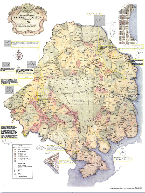
Fairfax County, Virginia
The following landowner maps of Fairfax County, Virginia have been marked with a best estimate of their locations based on the surveys and information given in the records for the Gowing/Goin families living in Fairfax County in the early 1700s.

Fairfax Co landowner North East section marked
1710-1722 – Chart of George Mason III showing purchase of Thomas Gowing‘s 653acres, in Fairfax/Stafford Co, Va.
http://www.gunstonhall.org/georgemason/landholdings/land_purchases.html

Fairfax Co landowner Southern section marked

Fairfax Co landowner North West section marked
1725 Nov 12th, William Gowen – received another land grant on Pope’s Head Run in Fairfax County, Virginia. Reference is made to the grant in a lease made by “Ambrose Gowing to Kathrine Gowing, widow.” Ambrose Gowen leased land from his mother described as a “grant to William Gowing, father of the said Ambrose Gowing by patent bearing date 12th, 11th month, 1725.” The lease, recorded 8th, 3rd month, 1726 in Stafford County Deed Book 1, page 353, was witnessed by George Mason, Joseph Haines and Brent Hutnall. A release appears in Stafford County Deed Book 1, page 354. Stafford Co, Va http://interactive.ancestry.com/48438/VALandRecords-003308-423/345936?backurl=http%3a%2f%2fsearch.ancestry.com%2fcgi-bin%2fsse.dll%3fdb%3dFLHG-VALandRecords%26gss%3dsfs28_ms_db%26new%3d1%26rank%3d1%26msT%3d1%26gsfn%3dAmbrose%26gsfn_x%3d0%26gsln%3dGowing%26gsln_x%3d0%26MSAV%3d0%26uidh%3dm37&ssrc=&backlabel=ReturnSearchResults&rc=920,459,1057,491;389,540,548,572;546,541,685,572
1729 Nov 15 – By virtue of a warrant from the proprietors office dated the 5th day of August 1729. Surveyed for Mr Charles Carter of the County of Lancaster a certain parcel of land situate lying and being in the County of Stafford on the head branches of Pohick and Popes Head Runs and joyning to the lands of Terence Ryley; the said land being bounded as followeth … land of Terence Ryley and extending thence with the sd Ryleys lines … by Walter Griffins rolling road … near Widow Coffer’s line … 875 acres … (William Going’s land is in the center of the drawn survey)
http://image.lva.virginia.gov/LONN/NN-1/239/0391_0393.pdf

1729 Nov 15 Survey for Charles a Robert Carter Jr near William Going in Stafford Co, Va
37) 1730 Feb 15 – C-105 – Thomas Ford of Stafford Co 451 acres in Stafford Co on Popeshead Run . . . adjacent to Capt Connyers and William Going. p106. Va. Land Trans – Stafford Co, Va.
38) 1730 March 4 – C-118 – James Going and Simon Pearson of Stafford Co 652 acres in Stafford Co on Four Mile Run near Brandymore adj Thomas Pearson dec’d, William Gunnel, on Pimets Run. 4 March 1730. p. 106 (p. 127 is James Going adjacent to Maj John Colvill in 1739). Va. Land Trans – Stafford Co., Va. 1730 March 4 – James Gowin 652 acres, Book C, p 118
https://www.familysearch.org/ark:/61903/3:1:3Q9M-CSY6-W9Q4-M?i=732&cat=414338
1730 Apr 28 survey of James Going and Simon Pearson for 652 acres in Stafford Co Va:

1730 Apr 28 survey of James Going and Simon Pearson for 652 acres in Stafford Co Va snip 1
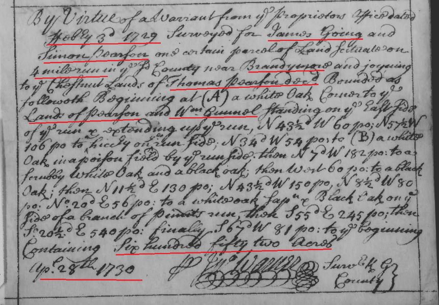
1730 Apr 28 survey of James Going and Simon Pearson for 652 acres in Stafford Co Va snip 2

42) 1731 May 16 … Whereas Robert Carter Junior of the County of Westmoreland … did on the 23d day of November … that Terence Reyley of the County of Stafford (now Prince William County) died seized of 217 acres of land in the said County without heirs or making any legal disposition thereof in his lifetime, Whereupon an inquisition concerning the said land is since taken and returned to our said office … John Peyton … brought in this verdice … “We do find that Terence Reyley died seized of 217 acres of land, as appears to us by certain deed from the Honorable the Proprietors of the Northern Neck, bearing date the 14th day of April 1727 … Reyley did not dispose of the said land in his life time, not left any heir that we know of; therefore we find that the aforesaid 217 acres of land doth escheat as by the said inquisition, bearing date the 14th day of April in the year 1731, doth and may more at large appear, and the said Robert Carter being the first presenter and desirous to be admitted tenant of the said land … grant and confirm unto the said Robert Carter all that said tract or parcel of land containing 217 acres … in the said County of Prince William on the branches of Popes head (it being a branch issuing out of the North side of Occoquon River) and bounded as followeth, viz … corner to the land surveyed for William Going on a branch of the said run called Rattle Snake Branch … across the said branch North … corner to the land of Thomas Ford and to the land of the said Going … thence binding with the said Going’s land North …
https://www.familysearch.org/ark:/61903/3:1:3Q9M-CSY6-W9Q9-X?i=788&cat=414338
1725 Sept 30 – By virtue of a warrant from the Proprietors Office dated 30th day of September 1725 surveyed for Terrence Ryley of the County of Stafford 217 acres of land lying and being in the County aforesd on the branches of Popeshead, it being a branch issuing out of the N side of Occoquan River and is bounded as follows … corner to the land surveyed for William Gowin on a branch of the sd called Rattle Snake Branch … March 6, 1726/7.
John Savage, Stafford Co, surveyor. (Original Survey of Land).
http://image.lva.virginia.gov/LONN/NN-1/241/0053_0055.pdf
59) 1737 Oct 26 – William Gowen bound to John Straughan
Apprentice, 26 Oct 1737, Prince William, Virginia, USA.
William Gowen, an orphan, age 10, was bound as servant and aprentice to John Straughan.
1737 Oct 3 – Charles Green is Minister of Truro Parish
Church Wardens are Jeremiah Branaugh, and Thomas Lewis.
Vestrymen are John Coloil, Augustine Wellington, Richard Osborn, William Peake, Edward Evans, Edward Barry, John Ferguson, John Ellisman
Payments made to: Charles Green as minister, William Berkeley, Catesby Cocke, Edward Barry, Joseph Johnston, Samuel Hull, John Summers, Richard Osborn, Mr William Payne, Marmaduke Lawson, Edward Evans, Capt Francis Ambros, John Christmas, Thomas Bennet, John Summers, Thomas Lewis, Doctor James Gile
Jeremiah Bronaugh, Thomas Lewis – Church Wardens of Truro Parish in Prince William County, and John Straughan of Prince William Co, in obedience to an order from Prince William County Court dated Oct 3, 1737 bind William Gowen an Orphan child aged 10 years a servant and apprentice unto said John Straughan to serve him the said John Straughan his heirs, executors or admins in all such lawful bindship . . . until age of twenty one . . . provide lodging, food, and drink . . . and teach him the ministry of a Tanner and to read English.
Signed: John Straughan
Witness: Robert Jones, Edward Barry.
(Image 19). pgs 12-13. Truro Parish Vestry Book. Prince Williams Co, Va
http://members.nova.org/~heintzer/pohick/vestrybook3.html

1737 Truro Parish Vestry Book with William Gowen bound out to Straughan p1 snip

1737 Truro Parish Vestry Book with William Gowen bound out to Straughan p2 snip
1737 Oct 26 – William Gowen John Straughan,
William Gowen – an Orphan – bound to John Straughan until 21 yrs – to be taught how to read English, and taught the ministry of a Tanner.
Pohick Church – in Lorton, Virginia
Truro Parish Colonial Vestry Book
(Church/Vestry of George Washington, George Mason, and other patriots)
Truro Parish, Va.
http://www.pohick.org/vestrybook.html (p. 19-20)
(Additional info from): http://jg1758.blogspot.com/2012/08/newly-found-possibility-william-gowen.html ; (Note: John Going died in 1721 so he is not the father. William b. 1680 died some time in 1725 – so he is not the father. Peter Going died in 1753, so he is not the father (as William b. 1727 is called an “orphan” in 1737). So of the Going men we know of in the area, that leaves James Gowing b. 1680, Thomas Going b. btw 1650-70 – maybe too old but who knows, Ambrose Going who disappears from records after his 1726 deed to his mother, and Moses Goin who only appears in one record in 1733 as possible fathers).
68) 1739 – Prince William County, Virginia Wills, Part 2, 1734-1920
Given Name: John
Surname: Goings
Year: 1739
Inheritance Tax/Book: C
Inheritance Tax Page #: 181
Ancestry.com. Prince William County, Virginia Wills, Part 2, 1734-1920 [database on-line]. Provo, UT, USA: Ancestry.com Operations Inc, 1999.
https://search.ancestry.com/cgi-bin/sse.dll?indiv=1&dbid=3898&h=1580&tid=&pid=&usePUB=true&_phsrc=kUu4651&_phstart=successSource
1739 Feb 4 James Going and Simon Pearson’s 652 acre tract is adjacent to John Colvill, Gabriel Adams, James Robertson, Robert Bates, and the late Rev Mr Brechin on Lubber’s Branch of 4 Mile Run, in Prince William County, Va. 1739 – James Going adj to John Colvill 652 acre grant, Book E, p 131 https://www.familysearch.org/ark:/61903/3:1:3Q9M-CSYD-X3TX-8?i=287&cat=414338

1739 James Going living adjacent to John Colville grant in Stafford Co Va snip and marked 1

1739 James Going living adjacent to John Colville grant in Stafford Co Va snip and marked 2
74) 1739 May 29 – E-81: 1739 May 29 … Mr John Awbrey of the County of Prince William hath informed that there is a certain tract or parcel of waste land in the said county … about four miles below the Falls of Potomack River yet ungranted … confirm unto the said John Awbrey … land situate and being in the said County of Prince William on Potomack River side about four miles below the Great of Lower Falls of the said River and joyning to the lands of William Strutfield, Thomas Owsley, and Mr Robert Alexander and near the land of Thomas Gowing and bounded as by a survey made by Mr James Thomas as followeth .. on the west side the mouth of a Branch called Wincopin Branch opposite to the lower end of an Island in the said Potomack River called Malard’s Island and near a corner of a tract of land formerly survey’d for the aforesaid Strutfield … in the line of the land of the said Thomas Owsley … along Owsley’s line … in a line of the land of the said Robert Alexander … along the line of Alexander …thence up the said Patomack River … to the beginning. Containing 86 acres …
https://www.familysearch.org/ark:/61903/3:1:3Q9M-CSYD-X3TN-8?i=237&cat=414338 , http://image.lva.virginia.gov/LONN/NN-5/291-2/1-100.html (page 81)
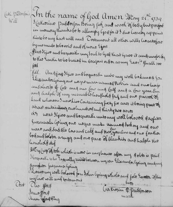
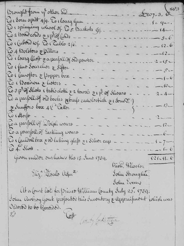
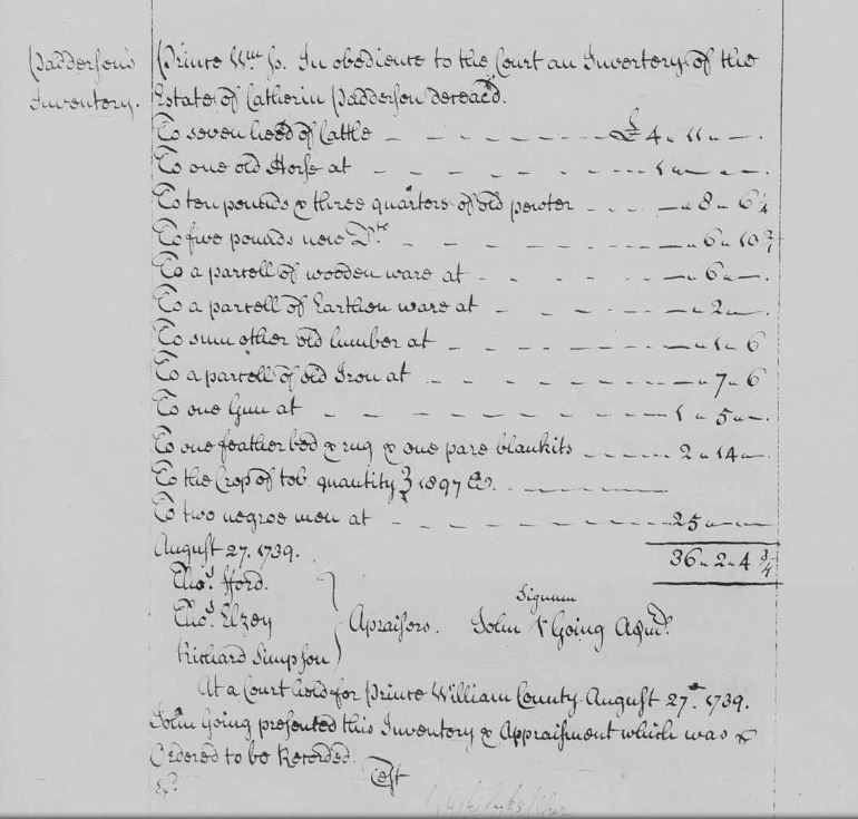
77) 1739 May 21 – Catherine Patterson/Gowen ; “23, July, 1739 –Catherine Patterson / Gowen wrote her will 21st, 5th month, 1739, – “Prince William County Will Book C”. “I, Catherine Padderson, being sick and weak in body. Unto my well beloved son, Elixander Going, one negro man named Robin and one horse and a horse colt and one cow and calf and a cow yearling and halph of my movable houshold stuf and one parcel of land whereon I now live containing sixty-six acres, it being part of a tract containing one hundred and thirty-two acres. Unto my well beloved daughter, Susannah Going, one negro man named Jackey and one mare and saddle, cow and calf and two cow yearlings and one feather bed and bolster, a rugg and one pare of blankits and half the household stuf. My crop of tob: which is now in my house after my debts is paid I bequeath to be equally divided between my son Elixander Going and my daughter Susannah Going. I leave my well beloved son, John Going, whole and sole executor of this, my last will and testament.; Catherin Padderson; Wits: Thomas Ford, Jane Ford, Ann Gladding“. “23, July, 1739. Presented in Court by John Going, sole executor herein named, who prayed certificate for obtaining a probate thereof, but it being suggested that the deceased’s husband is living, on the motion of the said John Going and giving security for his just and faithful administration of the said deceased’s estate, certificate is granted him for obtaining letters of administration.” “Bond of John Going, William Scutt and John Hollis unto Denis McCarty, Gent., justice. For £100, 23 July, 1739. John Going is administrator of Catherine Padderson, deceased. John Going. John Hollis. William Scutt; Witness: John Bowie, 23 July, 1739, Acknowledged and Ordered”. Estate: will, 21 May 1739, , Prince William, Virginia, USA. image from:
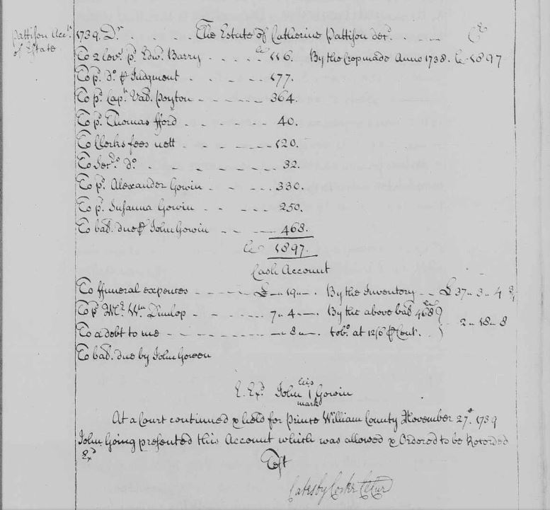
Library of Virginia, County and City Research in Virginia, County and City Records, Prince William County – Reel #18, Will Book, C, 1734 – 1744 c [ix] index, p. 7-526. Estate: probate, 23 Jul 1739, , Prince William, Virginia, USA. Catherine’s will accepted for probate and son John named admin. Estate: inventory, 27 Aug 1739, , Prince William, Virginia, USA. John Going presented, and the court recorded, the estate inventory on Aug 27 1739. ‘Apraisors’ were: Thos Ford, Thos Elzey, Richard Simpson. John Going admin. Estate: settlement, 27 Nov 1739, Prince William, Virginia, USA. Library of Virginia, County and City Research in Virginia, County and City Records, Prince William County – Reel #18, Will Book, C, 1734 – 1744 c [ix] index, p. 7-526. Pattison Acct of Estate 1739. The Estate of Catherine Pattison decd. pd Edward Barry 116 [Truro Parish clerk]; pd Valentine Payton 364; pd Thomas Ford 40; pd Alexander Gowin 330; pd Susanna Gowin 250; William Dunlop; pd John Gowin 468. John Going presented the account and it was recorded Nov 27, 1739. Prince William Co, Va. https://www.familysearch.org/ark:/61903/3:1:3QS7-L9PX-FQ2Y?i=100&cat=379047
1739 Last WIll and Testament of Catherin Padderson in Prince William Co Va p 1 bk C p 180

1739 Last WIll and Testament of Catherin Padderson in Prince William Co Va p 2 with admin orders bk c p 181
Probate records in Will Book C show:
1739 July 23. Presented in Court by John Going, sole executor herein named, who prays certificate for obtaining a probate thereof, but it being suggested that the deceased’s husband is living, on the motion of the said John Going and giving security for his just and faithful administration of the said deceased’s estate, certificate is granted him for obtaining letters of administration.” “Bond of John Going, William Scutt and John Hollis unto Denis McCarty, Gent., justice. For £100, 23 July, 1739. John Going is administrator of Catherine Padderson, deceased. John Going John Hollis William Scutt Witness: John Bowie, 23 July, 1739, Acknowledged and Ordered” The inventory of the estate, which included two negro men valued at 25 pounds, totaled 36 pounds, 2 shillings, 4 3/4 pence and was presented to the court by John Gowen August 27, 1739. The account which was allowed and ordered by Prince William County Probate Court, read: “The estate of Catherine Pattison, deceased. To 2 levs. pd. Edwd. Barry 116 (tobo.) To pd. Capt. Val Peyton 364 To pd. Thomas Ford 40 To pd. Alexander Gowin 330 To pd. Susanna Gowin 250 To bal due per John Gowin 468 To pd. Mr. Wm. Dunlop 7:4:- John (X) Gowin [“To” is apparently an abbreviation for “Total;” “tobo” is apparently an abbreviation for “tobacco”.]

1739 Last WIll and Testament of Catherin Padderson in Prince William Co Va p 3 with inventory bk C p 182
1739 Last WIll and Testament of Catherin Padderson in Prince William Co Va p 4 with inventory bk C p 183
1739 Last WIll and Testament of Catherin Padderson in Prince William Co Va p 5 with inventory bk c p 188

1739 Last WIll and Testament of Catherin Padderson in Prince William Co Va p 6 with inventory bk c p 195
1739 Last WIll and Testament of Catherin Padderson in Prince William Co Va p 7 with account bk c p 199
79) 1739 June 12: STAFFORD COUNTY VA WILL BOOK M; 1729-1748; THE ANTIENT PRESS pp. 271-273 Dr.
Bk M, pg 271
1733 Capt SIMON PEARSONS Estate
April 27:
To NATHAL. CHAPMAN Contra To 1 drest akin for his son,
paid RICHD. FLETCHER for goods,
delivered JAMES WADE for his freedom dues,
cash paid Coll. NICHS. SMITH, 7 gallons Rum at the funeral,
May 13
To paid Richard Fletcher for sundries, viz 2 hanks silk 10 lib cro sugar, 3 yd black ribbon, 7 gallons rum at the funeral.
paid Hawleys and Godfrey for Levies for 1732,
paid Capt WASHINGTON & Co. for Sundrys,
July 4
to cash paid JAMES CARTER for Quit rents of 7246 acres of land @ 2/ Sterl p hundred 25 p ct on do to make it currency,
to cash paid James Carter for an order from GEO. BUCHANAN on accot. Capt ARBUTHNOTS estate,
To WILLIAM HALES accot.,
July 13
To paid JOHN GRANT acct,
To paid Mr. NELSON for a hat band and gloves for THOMAS PEARSON,
To William Hale’s acct
July 28
To paid WILLIAM HERLE in part for his acct,
Aug 10
To paid RICHD FLETCEHER for galls rum and Sugar for the reaping,
To paid THOMAS EVES for note,
To paid Thomas Eves for making a mourning coat. for Thos. Pearson
To paid JOHN SMITH for setting up ton of cask as by his acct,
To payd JAMES WAUGH for coat hire,
paid PETER Hedguian Levies,
Cr.
1733 June 16
By a Note reced of JAMES GOING
By a Note recd of JOHN PAGE,
By Cash reced THOS. PEARSON,
By a note recd of John Page.
By a Note recd of EDWARD SNOXELL,
By a Note recd of GEORGE SYMSON,
By a Note recd of Edward Snowell
July 16
By Cash of DARBY BRYAN,
By note of JOHN MERCER,
By note of JOHN HERLE,
Aug 10th
By crop reced made at the home plantation on Potomack creek,
By ditto made in Pr. William,
By cash recd for the warehouse rent
By Note reced of JAMES SUDDUTH,
By Note reced of EDWARD WILLIAMS,
By Note reced of THOS SMITH, Rappa.
By Note reced of THOMAS FURR,
By Note reced of JOHN PAGE,
By Note reced of STEPHEN FULLER,
By Note reced of EDWD. WILLIAMS,
By Note reced of SIMON BOWLING,
By cash recd of WM. NORTHCOAT,
By notes recd of LEWIS ELSEY,
cash reced for the warehouse rent 1733
By William Northcoat.
))))))))))))))))))))))
Bk M, Pg 272
Aug 18
to paid JOHN WITHERS HARPER for a debt,
to paid JOHN MERCER acct,
to paid WM. DENT,
to paid MARY SHAVONS acct.
shipped to JAMES BUCHANAN,
Shipped in BUCKERIDGCE,
to paid CATESBY COCKS notes,
to paid Grigsby`s Judgment,
to paid Capt. SPOORE for Inspection he paid,
paid Marlbro Inspectors 4 crop hhds.
to paid WM. BROOKSHIRES acct.
1734 Augt. 10
to paid Capt HEDGMAN’S account levies.
to paid WM. WALKER for a coffin,
to paid SARAH JEWARS acct,
to paid Mr, SCOTT for the funeral sermon,
to paid Mr. CLAIBORNE for clerks note,
to paid Saml. TIMMONS acct,
to paid JOHN GRANT for collecting 650 lb tobacco
to paid the inspector of 7 hhds Tobo had out of hunting creek warehouse and ships in hoard the Smith Capt. BUCKRIDGE @ 3/.
July 5
to paid JAMES CARTER for quit rents 5636 acres land 1733 Sterling is currancy
to paid THOMAS HARISSON SENR. for a Legacy left him,
March 6
to paid MOSELY BATTALEY for a fee agst TRAMELL
to paid EBENEZER MOSS his acct Smiths work,
to paid Mr Mercer for David Davis’s acct proved
to paid Capt Colvil’s acct
to paid Mrs Spoores acct
by Thomas Pearson as recd of him
by John Withers Harper for a gun
by James Robinson
by Lewis Elsey as recd of Thomas Smith
Errors Excepted
Signed By: Nathaniel Chapman, Const Chapman
)))))))))))))))))
Bk M, Pg. 273
The Estate of Simon Pearson decd to Thomas Pearson Extr
to paid WPM. BROOKSHIRE,
to paid WM. HALE for MARY STRAUGHANS living at ye Quarter,
to paid EDWARD EMMS for Levies,
to paid GEORGE TRAMELLhis acct proved,
to paid JAMES BAXTER for levies,
to paid WILLIAM HERLE,
to paid Mr. COCKS clks note,
1735
To the hire of a Boat to carry Tobo to the warehouse 2 days at 20 p day,
to payd MICHAEL REGAN,
to payd EDWARD EMMS,
to payd ANN BALL,
to payd LEWIS ELSEY,
to paid EDWARD EMMES for levies,
to paid JERE BRANAUGH for levies,
to paid WILLIAM HERLE,
to paid Mr Cock’s clks note,
to paid Mr. NATHL. CHAPMAN,
to paid Mr Banaley 2 hoes
1734
by reced of NICHOLAS GRIMES,
by LEWIS ELSEY,
by WILLIAM BRUESTER,
by RICHD. RAKSTRAW,
by THOMAS COATHER,
by MOSES GOIN,
by THOMAS WEST,
by DAVID THOMAS,
by JAMES HALLEY,
by JOHN BURK,
By MICHAEL REGANS rent,
by Tobo reced HENRY WATSON
E E p Thos. Pearson
At Court held for Stafford County June 12th 1739 Nathaniel Chapman and Thomas Pearson Exrs of SIMON PEARSON deced presented account .. admitted to record.
Will Book, Vol Z, 1699-1709; Will Book, Vol M, 1729-1748. Stafford County, Virginia
https://www.ancestry.com/sharing/30393387?h=c5e690 (Bk M, pg 271)
https://www.ancestry.com/sharing/30393400?h=2a709b (Bk M, pg 272 & 273)
https://www.familysearch.org/ark:/61903/3:1:3Q9M-C9PF-DK99?i=403&cat=366578
1742 Oct 13 – John Gowin survey was done on Oct 13, 1742 for 155 acres in Fairfax Co Va – … survey for John Gowin Oct 13, 1742 … corner of Thomas Ford … with Ford’s lines … on the main branch of Popeshead … corner of Capt Connier’s … containing 155 acres. Chainmen listed as: John Stark, Alexander Gowin. Surveyor signed: W West. Fairfax Co, Va.
http://image.lva.virginia.gov/LONN/NN-1/213/0385_0388.pdf

1742 Oct 13 John Gowin survey for 155 acres in Fairfax Co Va_Page_3 marked snip
1742 Oct 30 – HENRY NODEN, forfeited by John Starks; no wart, survd 30 Oct. 1742; 138 acres. adj. Col Carter, widow Coffer, John Marton. Chain Carriers: John Gowen & Alexander Gowen. Surveyor: William West.
Northern Neck Warrants and Surveys Vol IV, Fairfax Co. Va {Peggy Joyner}
1742 Oct 30 – John Gowen had this survey Oct 30, 1742 for 144 acres in Fairfax Co Va – described as … near a branch of The North Run of Pohick and Corner to Robert Carter Esqr … line of the widow Coster (sp?) … line of Richard Simpson … Chainmen: John Stark, Alexander Gowen. Pilitt: John Gowen. Surveyor: William West.
http://image.lva.virginia.gov/LONN/NN-1/213/0378_0380.pdf

1742 Oct 30 survey for John Gowen for 144 acres in Fairfax Co Va_Page_2 marked snip
1743 Feb 15 – Thomas Going buys a lease on 100 acres of land for life from Robert Bates in Fairfax County, Va.
This Indenture made the xvth day of February in the year of our Lord 1743 between Robert Bates of Fairfax County, planter of the one part and Thomas Going of the same County planter of the other part.
Witnesseth that the said Robert Bates for and in consideration of the rents duties reservation & covenants herein after reserved and expressed on the part & behalf of the said Thomas Going his heirs and assigns to be paid done and performed hath demised granted let & to farm let and by these presents doth demis grant let & to farm let to the said Thomas Going one meseuage plantation, tenament & tract of land whereon he now dwells containing 100 acres more or less being part of a larger tract of land granted to the said Robert Bates & is bounded as followeth:
beginning at the Rattle Snake Run running up the road branch from thence to Fitshughes line from thence to Wests so along Solomons tract to Harrisons line & so to the beginning together with all houses outhouses gardens woods underwoods fields meadows patures water water courses & all other … and appurtenances thereunto belonging [ all mines minerals & quarters excepted ]
to have and to hold the said messuage, plantation, tenements & tract of land with the appurtenances to him the said Thomas Going his heirs and assignes for and during the term of their natural lives of the said Thomas Going, Elizabeth Carrol daughter of William Carrol & Henry Bates son of the said Robert Bates and of the longest liver of them yielding and paying yearly and every year during the term aforesaid unto the said Robert Bates his heirs and assignes on the 10th day of November the sum of six hundred and thirty pounds of lawfull tobacco & if it shall happen that the said yearly rent or any part thereof shall be behind & was paid for the space of 30 days after the day on which the same ought to be paid and no sifficient distress on the said premises to be found whererby the same may be levied that then & from hence forth it shall … be lawfulll to and for the said Robert Bates his heirs and assigns unto the above demised premises to reenter the land to have again reposses and enjoy as in his or their former estate
anything herein contained to the contrary notwithstanding and the said Thomas Going for himself his heirs executors admrs and assigns doth covenant promise and agree to & with the said Robert Bates his heirs and assigns to plant an orchard of 100 good winter apple trees on some convenient part of the demised premises within 3 years of the date hereof at 30 feet distance every way at least of each other and keep the same well fenced in ______________________________________ (part of deed appears missing)
…tobacco yearly during such subtenants abode thereon over and above the yearly rent above mentioned.
Signed: Robert Bates, Thomas Going.
Wit: Margaret Terrett, William M Carrol, William Henry Terrett.
Filed in Fairfax County Court on Feb 16, 1743 by Robert Bates.
Deed bk A1, p 101, Fairfax Co, Va
https://www.familysearch.org/ark:/61903/3:1:3Q9M-CS4V-BSFF-T?i=59&cat=202100
1743 Feb 15 – Robert Bates of Fairfax County Planter least of 100 acres to William Carrol of same County planter.
Lease of land of 100 acres … part of a greater tract granted to the said Robert Bates by deed from the proprietors office dated the 17 day of Dec 1742 … bounded along Fitzhughs line … to the main run of Hunting Creek … to Harrison’s line …to another tract granted to the said Robert Bates … to him the said William Carrol … for and during the term of the natural lives of the said William Carrol, Elizabeth his wife, and Ann their daughter, and of the longest liver of them … to plant an orchard of 100 good winter apple trees on some conveniet part of the demised premises within 3 years of the date hereof …
Signed: Robert Bates, William Carrol
Wit: Margaret Terrett, Thomas Going, Henry Terrett.
Recorded on Feb 16, 1743.
Deed bk A1, p 106, Fairfax Co, Va
https://www.familysearch.org/ark:/61903/3:1:3Q9M-CS4V-BSF6-9?i=62&cat=202100
1743 Feb 4 – Lease. Robert Bates, of Fairfax Co, planter, and William Perkins, same Co. Named in boundaries Gabriel Adams, Alexander Scott, clerk Thomas Farmes (or Fanner), now Hugh Wests, along line of land leased by Robert Bates to Thomas Going, lease for the natural lives of the said William Perkins, Valentine Perkins his son & Sara Perkins his dau for life. Wit. Mary Terrett, Ann Pearson. 15 Mch 1755, Deed bk A1, p. 139. Fairfax Co, Va
https://www.familysearch.org/ark:/61903/3:1:3Q9M-CS4V-BSFH-6?i=79&cat=202100
1743 Nov 27 – John Gowen is mentioned in a grant to William Ellzey dated November 27, 1743 as living adjacent to the Ellzey property “on Wolf Run and Ox Road, along with Col. Carter, Bond Veale, Thomas Ford and Tillet.” Northern Neck Grants F, 1742-1754, p. 144 (Reel 292). https://lva.primo.exlibrisgroup.com/permalink/01LVA_INST/altrmk/alma990008525510205756
On July 6, 1744 John Gowen receives Grant No. 368 for 155 acres “on a branch of the Popeshead and Pohick Rivers, adjacent to Thomas Ford and Capt. Connyers,” according to”Grants by the Proprietors of the Northern Neck of Virginia.” The land lay in Fairfax County, according to Northern Neck Grants F, 1742-1754, p. 187 (Reel 292). https://lva.primo.exlibrisgroup.com/permalink/01LVA_INST/altrmk/alma990008537220205756
On July 10, 1744 John Gowen receives Grant No. 371 for 144 acres “in a glade near a branch of North Run Pohick which corners Robert Carter,” according to “Grants by the Proprietors of the Northern Neck of Virginia.” It is also located in Fairfax County, according to Northern Neck Grants F, 1742-1754, p. 191 (Reel 292). The deeds are recorded in “Patents and Northern Neck Grants of Fairfax County, Virginia.” https://lva.primo.exlibrisgroup.com/permalink/01LVA_INST/altrmk/alma990008537230205756
http://ourberryfamily.com/berry/pictures/1744grantjohngowenfairfaxcova.jpg
1744 March 5 – John Goen and wife Mary to Thomas Ford, Lease & Release, Deed bk A1, p 349-354, Fairfax Co, Va
Lease: … between John Goen of the Parish of Truro in the County of Fairfax and Mary his wife of the one part and Thomas Ford of the parish and county aforesaid of the other part… John Goen and Mary his wife … sell unto the said Thomas Ford two certain parcels of Land one tract or parcel of land containing 56 acres the same more or less situate and being in the Parish and County aforesaid on the E side of Popes Head Run and bounded … in the Fork of the Rattle Snake Branch … part of a greater tract of land containing 112 acres granted to William Goen dec’d father to the said John Goen … deed from the proprietors office bearing date the 12th day of November 1725 … and also another tract or parcel of land containing by estimation 44 acres being part of a greater tract of land containing 155 acres situate … in the County of Fairfax aforesaid on Popes Head Run between Thomas Fords two former tracts of land and a tract of land formerly granted to David Waugh and bounded … on the main run’s corner to the said Thomas Ford thence along the said Fords line … to another corner of the said Ford … to the main run of Popes Head … on each side of the said run … the same being granted to John Goen by deed from the Proprietors office dated 6th day of July 1744 …
Signed: John Goen, Mary Goen
Wit: William King, John Ford, Robert Lindsey, Richard Simpson Junr, Giles Tillet, Alexander Anderson
1744 Apr 16 – lease proved by oaths of Giles Tillett, William King, and Richard Simpson Junr …
1745 March 6 – Release: … between John Goen of the Parish of Truro in the County of Fairfax and Mary his wife of the one part and Thomas Ford of the Parish and County aforesaid of the other part … confirm unto the said Thomas Ford … two certain parcels of land, one tract containing 56 acres… (described above in Lease) … the other tract containing 44 acres … (described above) …
Signed: John Goen, Mary Goen
Wit: William King, John Ford, Robert Lindsey, Richard Simpson Junr, Giles Tillet, Alexander Anderson
1745 Apr 16 – release recorded.
https://www.familysearch.org/ark:/61903/3:1:3Q9M-CS4V-BSX5-7?i=189&cat=202100
1744 Mar 6 – John Goen and wife Mary to Thomas Ford, Release, Deed bk A1, p 351, Fairfax Co, Va
https://www.familysearch.org/ark:/61903/3:1:3Q9M-CS4V-BSF3-8?i=190&cat=202100
1745 March 11 – Peter Gowing’s first wife, Isabel Gowing –
Isabel died March 11, 1745. p. 65
Overwharton Parish, Va
https://archive.org/stream/virginiaoverwhar00will#page/64/mode/2up
1745 May 28 – Peter Gowing marries Mary Sullivant –
Marriage recorded on May 28, 1745. p. 65
Overwharton Parish, Va.
https://archive.org/stream/virginiaoverwhar00will#page/64/mode/2up
1746 Mar 17 – F-270: Mr. Daniel Jenings of Fairfax Co. 1053 A. in said Co. Surv. Elias Davis. Jenings purchased 795 A. granted Rev. Mr. James Brechin. 20 Dec. 1716, 195 A. granted Capt . Simon Pearson 18 Feb. 1729, and 12 A. granted said Jenings 25 Nov. 1740. Resurv. added 51 A. surplus. Adj. Thomas Goings now Mr. George Mason granted 20 Jan. 1724, Major John Colvill, Lubbers Br., James Robertson, Gabriel Adams. 17 Mar. 1746. p 15
Land Trans – Fairfax Co.
1746 June 9 – John Goen and wife Mary to Edward Kirkland, Lease & Release, Deed bk B1 p 32-39, Fairfax Co, Va
Lease p. 32: … between John Goen of the Parish of Truro in the County of Fairfax and Mary his wife of the one part & Edward Kirkland of the parish and County aforesaid of the other part … the said John Goen and Mary his wife … sell unto the said Edward Kirkland one half of a certain parcel of land a tract or parcel containing 268 acres of land situate lying in parish & County aforesaid on the North side of Ocaquan below the mouth of the North Fork of the said Run Ocaquan and bounded … upon the said riverside being the uppermost corner tree of a tract of land belonging to Richard Ridgewell … along the said Ridgewells line .. at the mouth of the said Run thence down the water course of the said river to the beginning … it being a tract of land granted to Richard Kirkland dec’d & Cornelias Keeif father to the said Goens wife party to these presents by deed from the proprietors office bearing date the 23 day of November 1714 … & from the said Cornelias Keeif him his heirs … the half of the said parcel or tract of land aforementioned which the said Edward Kirkland is at this present possess …
Signed: John Gowen, Mary Gowen
Wit: John Bayless, William King, Bond Veale
1746 Aug 19 – At a Court held for Fairfax County .. this lease from John Goen & Mary Goen to Edward Kirkland was proved by the oaths of John Bayless, William King, and Bond Veale to be their act & Deed & admitted to record.
https://www.familysearch.org/ark:/61903/3:1:3Q9M-CS4V-BSXH-D?i=375&cat=202100
1746 June 10 – John Goen and wife Mary to Edward Kirkland, Release, Deed bk B1, p 35, Fairfax Co, Va
Release p. 35: … between John Goen of the Parish of Truro in the County of Fairfax and Mary his wife of the one part & Edward Kirkland of the parish and County aforesaid of the other part … confirm unto the said Edward Kirkland … one half of a certain parcel of land a tract parcel containing 268 acres … (description above in lease) …
Signed: John Gowen, Mary Gowen
Wit: John Bayless, William King, Bond Veale
1746 Aug 19 – At a court held for Fairfax County … this release from John Goen and Mary Goen to Edward Kirkland was proved by the oaths of John Bayless, William King & Bond Veale to be their act & Deed & admitted to record.
https://www.familysearch.org/ark:/61903/3:1:3Q9M-CS4V-BSX4-W?i=376&cat=202100
See the following original grant to Cornelius Keeif:
1713 Sept 4 – Cornelius Keiffe and Richard Kirkland receive 268 acres. On the North side of Occoquan River. Adj to Richard Ridgewell. Stafford County, Va. (Father of Mary Keith Gowing and Father in Law of John Gowing Sr). http://image.lva.virginia.gov/cgi-bin/drawer?retrieve_image=LONN&dir=/LONN/NN-3/289-2/289&image_number=0155&offset=%2B149&name=Grants+No.5+1713-1719+(VOL.1+p.1-130)&dbl_pgs=no&round= 1714 Nov 23, Cornelius Keeiffe (Keith) and Richard Kirkland receive a grant for 268 acres on the North side of the Occoquan River, adj to Rd. Ridgewell (Cornelius Keeiffe is the father of Mary Keith, wife of John Gowing Sr). http://image.lva.virginia.gov/cgi-bin/drawer?retrieve_image=LONN&dir=/LONN/NN-3/289-2/289&image_number=0155&offset=%2B149&name=Grants+No.5+1713-1719+(VOL.1+p.1-130)&dbl_pgs=no&round=
These 268 acres granted to Cornelius Keeiffe and Richard Kirkland are found on the following map (click to enlarge):
Fairfax Co landowner Southern section marked
Note: Some time in the mid to late 1720s, Cornelius Keiffe/Keith’s daughter Mary was married to John Going/Gowen.
1746 July 14 Lease: – John Gowen to Bond Veale, Lease & Release, Deed bk B1, p 24-29, Fairfax Co, Va
Lease p. 24: … between John Gowen of Truro Parish and the County of Fairfax planter of the one part & Bond Veale of the aforesaid Parish & County planter of the other part … the said John Gowen … doth bargain and sell unto the aforesaid Bond Veale … all that parcel of land containing by estimation 144 acres … which was granted to the said John Gowen by deed from the Proprietors office bearing date the 10th day of July 1744 … in the Parish and County aforesaid and bounded … near a branch of the North Run of Pohick and corner to Robert Carter Esqr thence with his line … in the line of the Widow Coffer … to the line of Richard Simpson …
Signed: John Gowen
Wit: William Grove, George Duren, John Duren.
1746 July 15 – John Gowen acknowledged this lease to Bond Veale to be his act and Deed which is admitted to record.
https://www.familysearch.org/ark:/61903/3:1:3Q9M-CS4V-BSXH-2?i=371&cat=202100
1746 July 15 – John Gowen to Bond Veale, Release, Deed bk B1, p 26, Fairfax Co, Va
Release p. 26: … between John Gowen of Truro Parish and the County of Fairfax planter of the one part & Bond Veale of the aforesaid Parish & County planter of the other part … John Gowen … doth fully acquit & discharge the said Bond Veale … confirm unto the said Bond Veale … land containing by estimation 144 acres … granted to the said John Gowen by deed from the proprietors office bearing the date the 10th day of July 1744 … (described in lease above) …
Signed: John Gowen
Wit: William Grove, George Duren, John Duren.
1746 July 15 – John Gowen acknowledged this release to Bond Veale to be his act and deed and Mary the wife of the said Gowen being privatly examined relinquished her right of Dower to the land by the said release …
https://www.familysearch.org/ark:/61903/3:1:3Q9M-CS4V-BSXZ-K?i=372&cat=202100
http://www.fairfaxcounty.gov/courts/circuit/pdf/deed-book-index-1742-1797.pdf
1747 Aug 17 – Alexander Gowen to Bond Veale, Lease & Release, Deed bk B1, p 253, Fairfax Co, Va
Lease:… between Alexander Gowen of Truro Parish and County of Fairfax planter of the one part and Bond Veale of the aforesaid Parish and County planter of the other part … Alexander Gowen …. sell unto the aforesaid Bond Veale …. land containing by estimation 56 acres … in the Parish of Truro and County of Fairfax … at the Division Line made mention of in Thomas Ford’s Deed of Sale bought of John Gowen …
Signed: Alexander Gowen.
Wit: Joseph Cockerill, Joseph Gardner, John Melton
1747 Aug 18 – Release: … between Alexander Gowen of Truro Parish and County of Fairfax planter of the one part and Bond Veale of the aforesaid Parish and County planter of the other part … Alexander Gowen … confirm unto the said Bond Veal … land containing by estimation 56 acres … situated … in the Parish of Truro and County of Fairfax … at the Division Lines made mention of in Thomas Ford’s deed of sale bought of John Gowen …
Signed: Alexander Gowen
Wit: Joseph Cockerill, Joseph Gardner, John Melton
Recorded Aug 18, 1747 by oath of Alexander Gowen and motion of Bond Veale.
https://www.familysearch.org/ark:/61903/3:1:3Q9M-CS4V-BS6P-F?i=505&cat=202100
See William Gowing’s grant and survey for 112 acres:
1725 Nov 12 – A-171: William Gowing of Stafford Co 112a in said Co on Rattlesnake Br of Popeshead Run. 12 Nov 1725. p. 82. Grant No. 131 according to “Grants by the Proprietors of the Northern Neck of Virginia.” “William Goings” receives Grant No. 131 November 12, 1725 for 112 acres “on Rattlesnake Branch of Popeshead,” according to “Grants by the Proprietors of the Northern Neck of Virginia.”
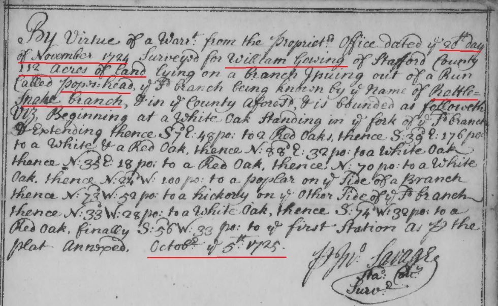
1725 Oct 5 survey of William Gowing for 112 acres in Stafford Co, Va snip 1

1725 Oct 5 survey of William Gowing for 112 acres in Stafford Co, Va snip 2
Link to survey: http://image.lva.virginia.gov/LONN/NN-1/240/0148_0150.pdf
1747 Oct 12 – Capt. John Minor, Charles Broadwater, Charles Green, John Hollis
Minister: Rev. Charles Green
Vestrymen: Capt. Lewis Ellzey, Capt. John Minor, Hugh West, Andrew Hutchison, Capt. Richard Osborn, Edward Evins, Robert Boggess, Col. John Colvill, Charles Broadwater, Capt. Jeremiah Bronaugh
Payments: Rev. Charles Green – salary, John Barry – clerk, John Wybird Dainty – clerk, Joseph Moxley – clerk, William Champrey – clerk, William Henry Ferrett – clerk, Philip Howell – sexton, Mary Bennit – sexton, Mary McDowell – sexton, William Grove – sexton, John Hollis for support of his son John disabled for 2 years, widow Richardson for support, Doctor John Robertson, Charles Griffin for keeping Thomas Wilkinson – paid to Hugh West, Mathew Bradley, John Graham, Robert Boggess, William Kitchen for taking care of Susanna Williams, Henry Fren for taking care of and burying Hannah Stevenson, John Simmons for his trouble with Hannah Forbes, John Tramol, John Keen for maintaining a poor child.
Signatures: Capt John West, Hugh West
Orders: Andrew Hutchison and Capt. Richard Osborn appt Church Wardens; payment for Philip Howell
Signatures: Charles Green, Andrew Hutchison, Richard Osborn, William Lowry Ferrett
Pohick Church – in Lorton, Virginia
Truro Parish Colonial Vestry Book
Truro Parish, Va.
http://www.pohick.org/vestrybook.html Pg 57, 58
1749: James Going and Alexander Going appeared in Stafford County on Green’s list of tithables. http://usgenwebsites.org/VAFairfax/1749%20fairfax%20tithables.pdf
1749 Stafford Co Va tax list with James Going and Alexander Going
1749 January 16, William Godfrey wrote his will January 16, 1749, and it was recorded March 20, 1753, according to Fairfax County Will Book B, page 13. Fairfax Co, Va
1749 May 17 – Court held May 17, 1749. The Action of Trespass Assault and Battery by John Holles against Richard Nelson the Defendant on his Motion hath a Special Importance granted him until the next court. Fairfax County, VA; Fairfax County Court Order Book, 1749-1754 p. 6, http://files.usgwarchives.net/va/fairfax/court/etal554gwl.txt , https://www.familysearch.org/ark:/61903/3:1:3Q9M-CS4V-B9YN-R?i=13&cat=193222
1749 May 17 – On the Complaint of JOHN HAMIL TON Gent. His Majestys Deputy Attorney It is Ordered that the Sherif Attach JOSHUA HARP, JAMES GRlMES and FRANCIS STREET so that he have them at the next Court to answer such things as shall be objected on his Majestys behalf and that he Summon JOHN STRAUGHAN, RlCHARD WHEELER, HENRY COLLOM2l and JAMES ROBERTSON to appear and give Evidence against them. Fairfax County Court Order Book, 1749-1754 p. 9
https://www.familysearch.org/ark:/61903/3:1:3Q9M-CS4V-B9T1-Q?i=14&cat=193222
1749 June 20 – The Petition of ALEXANDER GOING against JOSEPH WILLIAMS is dismist.
Fairfax County Court Order Book, 1749-1754 p. 17.
https://www.familysearch.org/ark:/61903/3:1:3Q9M-CS4V-B9Y6-Z?i=18&cat=193222
1749 June 21 – Between the R’t Hon’ble THOMAS Lord FAIRFAX Plaintif
} In Trespass for beating a Servant
JOSEPH SKELTON Defendant }
This day came here the partys by their Attorneys, and the Defendant by his attorney says he is in no wise guilty as the Plaintif complains against him in his Declaration and prays the same may be enquired of by the country and the Plaintif likewise, Thereupon it was commanded the Sherif that he should cause to come here twelve &c. who neither &c. to recognize &c. because as well &c. and the Jurors thereon impannelled being caIled namely, JOHN PAGAN, HARRY PIPER, THOMAS WREN, HUGH WEST Jr., JOHN NORWOOD, SAMPSON TURLEY, JOHN HURST, THOMAS SPEAKE, THOMAS WREN Jr., GARRARD TRAMMELL, JOHN STRAUGHAN and WILLIAM SMITH who being Elected tried and Sworn to say the truth of and upon the premisses upon their Oaths say that the Defendant is Guilty and assess the Plaintif damages by Occasion thereof besides his Costs and Charges to forty Shillings Sterling money. It is therefore considered by the Court that the Plaintifrecover of the said Defendant the said forty shillings Sterling money by the Jurors in their Verdict aforesaid assessed and his Costs by him about his Suit in this behalf laid out and expended and the Defendant in Mercy &c.
Fairfax County Court Order Book, 1749-1754 p. 19
https://www.familysearch.org/ark:/61903/3:1:3Q9M-CS4V-B9YH-9?i=19&cat=193222
1749 June 24 – WILLIAM REARDIN [sic] Plaintif} In Trespass for beating a Servant
GEORGE JOHNSTON Defendant }
This day came the parties by their Attorneys and the Defendant by his Attorney says that he is in nowise Guilty as the Plaintif complains against him in his declaration and prays the same may be enquired of by the Country and the pl’t likewise, Thereupon came a Jury namely GARRARD ALEXANDER, JOHN WEST Jr., HUGH WEST Jr., THOMAS WREN Sen., EDWARD EMMS, JOHN JENKINS, SAMUEL JENKINS, JAMES JENKINS, JOHN STRAUGHAN, JOHN KING, WALTER ENGLISH, and EZEKIEL JENKINS who being Elected tried and Sworn to say the truth in the Premisses upon their Oaths do say that the Defendant is Guilty as the Plaintif in his Declaration complains against him and assess damages by Occasion thereof besides his Costs and Charges to five pounds. It is therefore considered by the Court that the Plaintifrecover of the said Defendant the said five pounds by the Jurors in their Verdict aforesaid assessed and his Costs by him in this behalf expended and that the Defendant be taken &c.
Fairfax County Court Order Book, 1749-1754 p. 30
https://www.familysearch.org/ark:/61903/3:1:3Q9M-CS4V-B9YC-3?i=25&cat=193222
1749 June 24 – WILLIAM HICKS Esq. Plaintif
} In Trespass on the Case
JOHN KING Defendant }
This day came the Parties by their Attorneys and the Defendant by his Attorney says that he did not assume upon himself in manner and fonn as the Plaintif in his declaration against him complains and this he prays may be enquired of by the country and the Plaintif likewise, thereupon came a Jury namely, JOHN WEST Jun., HUGH WEST Jun., THOMAS WREN Sen., EDWARD EMMS, WALTER ENGLISH, JOHN JENKINS, SAMUEL JENKINS, EZEKIEL JENKINS, WILLIAM SENT, JOHN STRAUGHAN, and GARRARD ALEXANDER, who being Elected tried and Sworn to say the truth in the Premisses upon their Oaths do say that the Defendant did assume upon himself in manner and fonn as the Pl’t complains against him and assess damages by occasion of the nonperformance thereof besides his Costs and Charges to one thousand and Seventy five pounds of Crop Tobacco. Therefore it is considered by the Court that the Plaintifrecover of the said Defendant the said one thousand and Seventy five pounds of Crop Tobacco by the Jurors in their Verdict assessed and his Costs by him in this behalf laid out and expended and the Defendant in Mercy &c. Fairfax County Court Order Book, 1749-1754 p. 30-31
https://www.familysearch.org/ark:/61903/3:1:3Q9M-CS4V-B9YC-3?i=25&cat=193222
1749 Sept 30 – On the Petition of WILLIAM HICKS Esq. against ALEXANDER GOING Judgment is granted the Petitioner against the said Defendant for Six hundred and twenty eight pounds of Tobacco and four Shillings and Six pence current money by note of hand and Costs. Fairfax County Court Order Book, 1749-1754 p. 43.
https://www.familysearch.org/ark:/61903/3:1:3Q9M-CS4V-B9B9-B?i=31&cat=193222
1750 Mar 27 – Court held March 27, 1750. We present John Hollis Junior for being a common Swearer to the knowledge of two of this Jury. John Turley foreman. And also returned an Indictment against Walton English Ignoramus. Fairfax County, VA; Fairfax County Court Order Book, 1749-1754 p. 55, http://files.usgwarchives.net/va/fairfax/court/etal554gwl.txt
https://www.familysearch.org/ark:/61903/3:1:3Q9M-CS4V-B9Y9-Y?i=37&cat=193222
143) 1750 April – Ordered that James Hughs pay Mary Going one hundred pound of tobacco for 11 days attendance as an evidence against. Stafford County Court Order book (1749-1755) (Page 34).
http://digitool1.lva.lib.va.us:1801/view/action/nmets.do?DOCCHOICE=134185.xml&dvs=1446217229055~634&locale=en_US&search_terms=&adjacency=&VIEWER_URL=/view/action/nmets.do?&DELIVERY_RULE_ID=1
1750 Apr 2 – John Straughan in jury. Fairfax County Court Order Book, 1749-1754 p. 75
https://www.familysearch.org/ark:/61903/3:1:3Q9M-CS4V-B9Y8-3?i=66&cat=193222
1750 June 29 – John Straughan on jury. Fairfax County Court Order Book, 1749-1754 p. 95
https://www.familysearch.org/ark:/61903/3:1:3Q9M-CS4V-B9Y3-J?i=76&cat=193222
1750 June 30 – John Cannady on jury.
Fairfax County Court Order Book, 1749-1754 p. 96
https://www.familysearch.org/ark:/61903/3:1:3Q9M-CS4V-B9Y3-J?i=76&cat=193222
1750 June 30 – John Straughan and John Cannady on a jury.
Fairfax County Court Order Book, 1749-1754 p. 97
https://www.familysearch.org/ark:/61903/3:1:3Q9M-CS4V-B9Y8-2?i=78&cat=193222
1751 Mar 30 – Court held March 30, 1751. On the petition of John Milstead against Alexander Gowen, John Summers William Berckley and John Ward or any two of them are Ordered to view and Value the work done by the petitioner for the Defendant and report the Value thereof to the next court. Fairfax County, VA; Fairfax County Court Order Book, 1749-1754 p. 151, http://files.usgwarchives.net/va/fairfax/court/etal554gwl.txt , https://www.familysearch.org/ark:/61903/3:1:3Q9M-CS4V-B9TR-J?i=104&cat=193222
(see other orders on same day regarding Alexander Gowen and Moses Hollis – out of same case):
1751 Mar 30 – Court held March 30, 1751. Joseph Bayloy au Evidence for John Milstead against Alexander Gowen having attended seven Days Ordered he to pay him for the same according to Law. Fairfax County, VA; Fairfax County Court Order Book, 1749-1754 p. 151, http://files.usgwarchives.net/va/fairfax/court/etal554gwl.txt, https://www.familysearch.org/ark:/61903/3:1:3Q9M-CS4V-B9TR-J?i=104&cat=193222
1751 Mar 30 – Court held March 30, 1751. Moses Holles au Endowed for John Milstead against Alexander Gowen having attended seven days ordered that he to pay him for the same according to law. Fairfax County, VA; Fairfax County Court Order Book, 1749-1754 p. 151, http://files.usgwarchives.net/va/fairfax/court/etal554gwl.txt
https://www.familysearch.org/ark:/61903/3:1:3Q9M-CS4V-B9TR-J?i=104&cat=193222
1751 Mar 30 – Court held March 30, 1751. Moses Hollis au Evidence for Jane Purcel against Joseph Stevens and Alexander Gowen having attended Seven Days Ordered. She to pay him for the same according to Law. Fairfax County, VA; Fairfax County Court Order Book, 1749-1754 p. 151, http://files.usgwarchives.net/va/fairfax/court/etal554gwl.txt
https://www.familysearch.org/ark:/61903/3:1:3Q9M-CS4V-B9TR-J?i=104&cat=193222
1751 Mar 30 – Court held March 30, 1751. John Simpson au Evidence for Jane Purcel against Joseph Stevens and Alexander Gowen having attended Seven Days Ordered. She to pay him for the same according to Law and coming and returning twice thirty Miles. Fairfax County, VA; Fairfax County Court Order Book, 1749-1754 p. 151, http://files.usgwarchives.net/va/fairfax/court/etal554gwl.txt
https://www.familysearch.org/ark:/61903/3:1:3Q9M-CS4V-B9TR-J?i=104&cat=193222
1751 Mar 30 – Court held March 30, 1751. Thomas Remy au Evidence for Jane Purcel against Joseph Stevens and Alexander Gowen having attended Seven Days Ordered. She to pay him for the same according to Law and coming and returning twice thirty Miles. Fairfax County, VA; Fairfax County Court Order Book, 1749-1754 p. 151, http://files.usgwarchives.net/va/fairfax/court/etal554gwl.txt
https://www.familysearch.org/ark:/61903/3:1:3Q9M-CS4V-B9TR-J?i=104&cat=193222
1751 Apr 2 – Court held April 2, 1751. On the petition of John Holles against William MacMillion Judgement is granted the Petitioner against the said Defendant for three hundred and Eighty pounds of Tobacco and four Shillings current money by note of hand with costs. Fairfax County, VA; Fairfax County Court Order Book, 1749-1754 p. 150, http://files.usgwarchives.net/va/fairfax/court/etal554gwl.txt
https://www.familysearch.org/ark:/61903/3:1:3Q9M-CS4V-B9TR-J?i=104&cat=193222
1751 June 25 – Lease and release from Benjamin Rust to John Rains were proved by the oaths of Fielding Turner, Vainout Lewis, and Richard Colemand three of the evidences to be the acts and deeds of the said Benjamin Rust and admitted to record. Fairfax County Court Order Book, 1749-1754 p. 158.
https://www.familysearch.org/ark:/61903/3:1:3Q9M-CS4V-B9YQ-B?i=108&cat=193222
1751 Sept 26 – On the petition of John Milstead against Alexander Gowen judgment is granted the petitioner against the said Defendant for two pounds ten shillings current money and his costs by him in this behalf expended according to the report of the referrees.
Fairfax County Court Order Book, 1749-1754 p. 169.
https://www.familysearch.org/ark:/61903/3:1:3Q9M-CS4V-B9TG-K?i=113&cat=193222
1752 Jan 1 – Court held Jan 1, 1752. John Holes, Paid 12 Lbs tobacco by County for levies overpaid. Fairfax County, VA; Fairfax County Court Order Book, 1749-1754 p. 179, http://files.usgwarchives.net/va/fairfax/court/etal554gwl.txt
https://www.familysearch.org/ark:/61903/3:1:3Q9M-CS4V-B9T5-X?i=118&cat=193222
1752 Feb 8 – A claim of Notley Holles for taking up a runaway servant John Steward belonging to Thomas Elliott of Prince William County was proved and ordered to be certified to the assembly.
Fairfax County Court Order Book, 1749-1754 p. 183.
https://www.familysearch.org/ark:/61903/3:1:3Q9M-CS4V-B9TG-X?i=120&cat=193222
1752 May 22 – The attachment of Thomas Turnbull against Moses Holles is continued.
Fairfax County Court Order Book, 1749-1754 p. 203
https://www.familysearch.org/ark:/61903/3:1:3Q9M-CS4V-B9YM-F?i=130&cat=193222
1752 May 22 – The attachment of John Hammet against Moses Holles is dismist.
Fairfax County Court Order Book, 1749-1754 p. 204
https://www.familysearch.org/ark:/61903/3:1:3Q9M-CS4V-B9T5-H?i=131&cat=193222
1752 June 17 – Edmund Sands is appointed Overseer of the Road whereof Daniel Thomas was lately Surveyor Ordered that he do keep the same in repair according to Law and that the Persons to wit Thomas Davis Samuel Davis, Isaac Hardin John Bond Richard Canary John Colvills Tuskarora hands. John Dewit William Ross. William Mead John Cannaday – William Williams. Minors Quarter hands. John Piles William Berry John Radcliff and Benjamin Shreive. do work on the said Road under his directions –
https://www.virginiadot.org/vtrc/main/online_reports/pdf/03-r19.pdf
1752 July 21 – On a Bill preferred by Mary Strahan against her husband John Strahan for alimony ordered the said Strahan be summoned to the next Court to answer the same and give good security for performing the Courts decree.
Fairfax County Court Order Book, 1749-1754 p. 213
https://www.familysearch.org/ark:/61903/3:1:3Q9M-CS4V-B9TT-5?i=135&cat=193222
1752 July 24 – Ordered that John Strahan immediately pay Mary Strahan his wife four pounds current money towards her support and maintenance and so yearly until a definitive decree be given by this court on behalf of the said Mary on a Bill preferred by her for that purpose.
Fairfax County Court Order Book, 1749-1754 p. 219
https://www.familysearch.org/ark:/61903/3:1:3Q9M-CS4V-B9TL-V?i=138&cat=193222
1752 Nov 24 – Thomas Turnbull mercht against Moses Hollis} On Attachment
The suit is dismist.
Fairfax County Court Order Book, 1749-1754 p. 261
https://www.familysearch.org/ark:/61903/3:1:3Q9M-CS4V-BSMQ-J?i=159&cat=193222
1752 Dec 21 – Moses Hollis against Roger Toles} On Petition
It is considered that the said Moses shall recover against the said Roger the sum of three pounds and also his costs. William Ellzey Sen became the lts security for the clerks & sheriffs fees.
Fairfax County Court Order Book, 1749-1754 p. 281
https://www.familysearch.org/ark:/61903/3:1:3Q9M-CS4V-B91P-Z?i=169&cat=193222
1753 Jan 16 – Court held Jan 16, 1753. James Hollis being brought before the Court is charged with stealing a great Coat the property of Benoni Halley on hearing the Evidences against him it is Ordered that he remain in Custody until he give sufficient security himself in one hundred Pounds Sterling and his Security’s such in fifty pounds sterling for his the said James Hollis appearance at May Court next answer the same. Fairfax County, VA; Fairfax County Court Order Book, 1749-1754 p. 298, http://files.usgwarchives.net/va/fairfax/court/etal554gwl.txt
https://www.familysearch.org/ark:/61903/3:1:3Q9M-CS4V-B912-F?i=178&cat=193222
1753 Jan 17 – Court held Jan 17, 1753. James Hollis, John Hollis & William Gladin acknowledged themselves indebted to our sourvereign Lord the King his heirs & successors (Dist) the said James Hollis in the sum of one hundred pounds Sterling & the said John Hollis & William Gladin in the sum of fifty pounds sterling upon condition that the said James Hollis do appear at May Court next to answer a bill of Indictment to be Preferred against him. Fairfax County, VA; Fairfax County Court Order Book, 1749-1754 p. 299, http://files.usgwarchives.net/va/fairfax/court/etal554gwl.txt
https://www.familysearch.org/ark:/61903/3:1:3Q9M-CS4V-B912-F?i=178&cat=193222
1753 Mar 21 – Court held March 21, 1753. A Deed from John Hollis to James Swan proved by Daniel McCarty and John Melton two of the witnesses & admitted to court. Fairfax County, VA; Fairfax County Court Order Book, 1749-1754 p. 309, http://files.usgwarchives.net/va/fairfax/court/etal554gwl.txt
https://www.familysearch.org/ark:/61903/3:1:3Q9M-CS4V-BSMW-P?i=183&cat=193222
1753 May 16 – Court held May 16, 1753. Our sovereign Lord the King against James Hollis-On an Indictment. This day came Hugh West Gent. Deputy Attorney for our Sovereign Lord the King and the said James under the custody of Charles Broadwater Gent. Sheriff to the Barr in his Proper person came and being asked home of the Felony a foresaid he would acquit himself the said James saith that he of the felony aforesaid to him in form aforesaid improved in not Guilty and thereof for good and ill puts himself upon the Country Therefore Imediately causes a Jury thereof to come and the Jurors of the jury aforesaid by the aforesaid sheriff being impaneled and called that is to say that Thomas Smith, Robert Thomas, John Guefs, Robert Boggss’s, John Ashford, William Tramell, William Scott, John Summers, Edward Violet, John West, Barnaby Currey & William Duling came; who to say the huth of and upon the Promises ___to the said James Hollis imposed chosen hied and sworn say upoin their oaths that the said James Hollis is guilty of this felony to him in form as Imposed in manner and for as by the Indictment ato it is supposed upoin which the said James Hollis being spoken unto if he had any thing for himself to offer, or could say why the Court aforesaid is Judgmeent ought not to Proceed and he saying Nothing but what at first he had said Upoin this then and there it is Considered by the Justices here that the said James Hollis be led to the Publick whipping Post and there receive thirty nine Lashes on his bare back wellaid on and that he remain in Custody til he give sufficient security for his good behaviour and Costs. John Hollis became security to pay costs. Fairfax County, VA; Fairfax County Court Order Book, 1749-1754 p. 345-346, http://files.usgwarchives.net/va/fairfax/court/etal554gwl.txt
https://www.familysearch.org/ark:/61903/3:1:3Q9M-CS4V-B91P-7?i=201&cat=193222
1753 May 16 – Besnoni Halley an Evidence for our sovereign Lord the King against James Hollis having Attended three days ordered that the said James to pay him seventy five Pound of Tobacco. Fairfax County, VA; Fairfax County Court Order Book, 1749-1754 p. 345-346, http://files.usgwarchives.net/va/fairfax/court/etal554gwl.txt
https://www.familysearch.org/ark:/61903/3:1:3Q9M-CS4V-B91K-F?i=202&cat=193222
1753 May 16 – John Ellzey an Evidence for our sovereign Lord the King against James Hollis having attended three days ordered that the said James to pay him Seventy Five Pounds of Tobacco. Fairfax County, VA; Fairfax County Court Order Book, 1749-1754 p. 345-346, http://files.usgwarchives.net/va/fairfax/court/etal554gwl.txt
https://www.familysearch.org/ark:/61903/3:1:3Q9M-CS4V-B91K-F?i=202&cat=193222
1753 May 16 – Sarah Say an Evidence for our sovereign Lord the King against James Hollis having attended three days ordered that the said James to pay him Seventy Five Pounds of Tobacco. Fairfax County, VA; Fairfax County Court Order Book, 1749-1754 p. 345-346, http://files.usgwarchives.net/va/fairfax/court/etal554gwl.txt
https://www.familysearch.org/ark:/61903/3:1:3Q9M-CS4V-B91K-F?i=202&cat=193222
1753 May 16 – Joseph Stevens an Evidence for our sovereign Lord the King against James Hollis having attended one day ordered that the said James to pay him Twenty Five Pounds of Tobacco. Fairfax County, VA; Fairfax County Court Order Book, 1749-1754 p. 345-346, http://files.usgwarchives.net/va/fairfax/court/etal554gwl.txt
https://www.familysearch.org/ark:/61903/3:1:3Q9M-CS4V-B91K-F?i=202&cat=193222
1753 May 16 – Court held May 16, 1753. James Hollis & John Hollis of Fairfax County in open Court severally acknowledged themselves indebted to our sovereign Lord the King his heirs and successors (vizt) the said James Hollis in fifty Pounds of the said John Hollis in twenty five pounds On Condition that the said James be of good behaviour towards his Majesty and all his Siege people for a year and a day. Fairfax County, VA; Fairfax County Court Order Book, 1749-1754 p. 348. http://files.usgwarchives.net/va/fairfax/court/etal554gwl.txt
https://www.familysearch.org/ark:/61903/3:1:3Q9M-CS4V-BSMM-D?i=203&cat=193222
1753 May 21 – Court held May 21, 1753. John Hollis against John Dalton, Admr. Of Ann Gladin, Dec’d., On Petition. The suit is Continued. Fairfax County, VA; Fairfax County Court Order Book, 1749-1754 p. 374, http://files.usgwarchives.net/va/fairfax/court/etal554gwl.txt
https://www.familysearch.org/ark:/61903/3:1:3Q9M-CS4V-B912-S?i=216&cat=193222
1753 May 22 – Peter Going died at Priscilla Hayes’ – May 22, 1753.
Overwharton Parish, Va
https://archive.org/stream/virginiaoverwhar00will#page/70/mode/2up
1753 May 23 – Court held May 23, 1753. Sibbilla Hall by John Hollis her next friend against Thomas Hall. In chaneory. The Defendant failing to appear it is ordered that an attachment be issured against him returnable to the next Court. Fairfax County, VA; Fairfax County Court Order Book, 1749-1754 p. 393, http://files.usgwarchives.net/va/fairfax/court/etal554gwl.txt
https://www.familysearch.org/ark:/61903/3:1:3Q9M-CS4V-B915-R?i=225&cat=193222
1753 June 20 – Court held June 20, 1753. John Hollis against John Dalton, Admr. of Ann Gladin, Dec’d., On Petition. Suit is Cont.d [Continued]. Fairfax County, VA; Fairfax County Court Order Book, 1749-1754 p. 408, http://files.usgwarchives.net/va/fairfax/court/etal554gwl.txt
https://www.familysearch.org/ark:/61903/3:1:3Q9M-CS4V-BSMM-J?i=233&cat=193222
1753 Aug 23 – James Leith against James Gowen} On petition
It is considered that the said James recover against the said James Gowen three pounds three shillings & nine pence and also his costs.
Fairfax County, Va – Order book, 1749-1754. p. 446.
https://www.familysearch.org/ark:/61903/3:1:3Q9M-CS4V-B91K-L?i=252&cat=193222
1753 Sept 18 – James Gowen against Daniel Talbut} Trespass assault & battery
On the Defts motion he hath leave to imparte.
Fairfax County, Va – Order book, 1749-1754. p. 452.
https://www.familysearch.org/ark:/61903/3:1:3Q9M-CS4V-B91Y-5?i=255&cat=193222
1753 Sept 18 – James Gowen against Samuel Talbut} Trespass assault & battery
The aforesaid Plt altho solemnly called came not nor further prosecuted his bill aforesaid against the said Deft. Therefore it is considered that the Plt take nothing by his bill but for his false clamour be in mercy etc, the said Deft go therof without day and recover against the said Plt the sum of five shillings and also his costs by him about his defence in this behalf sustained & the said Deft have thereof execution.
Fairfax County, Va – Order book, 1749-1754. p. 453.
https://www.familysearch.org/ark:/61903/3:1:3Q9M-CS4V-B91Y-5?i=255&cat=193222
1753 Oct 16 – Ordered that the Churchwardens of Truro Parish bind Catharine Gladen an orphan, to Robert Bland according to law who is to learn her to read & write.
Fairfax County, Va – Order book, 1749-1754. p. 459.
https://www.familysearch.org/ark:/61903/3:1:3Q9M-CS4V-B91P-F?i=258&cat=193222
1753 Oct 16 – Job Jenkins against Moses Hollis} On attachment
The suit is dismist.
Fairfax County, Va – Order book, 1749-1754. p. 468.
https://www.familysearch.org/ark:/61903/3:1:3Q9M-CS4V-B917-6?i=263&cat=193222
1753 Nov 22 – Court held Nov 22, 1753. John Hollis against John Dalton Admr of Ann Gladin Dec’d. On Petition. It is considered that the said John Hollis recover against the said John Dalton three pounds seven shillings & one penny half penny & also his costs or to be levied of the goods & chattels of the said Ann which hereafter shall come to the hands of the said John Dalton to be admonished. Fairfax County, VA; Fairfax County Court Order Book, 1749-1754 p. 482, http://files.usgwarchives.net/va/fairfax/court/etal554gwl.txt
https://www.familysearch.org/ark:/61903/3:1:3Q9M-CS4V-B91G-9?i=270&cat=193222
1753 Nov 23 – Court held Nov 23, 1753. John Hollis against John Laughlin; On Petition. It is considered that the said John Hollis recover against the said John Laughlin six hundred and fifty pounds of Crop Tobacco & also his Costs &c. Fairfax County, VA; Fairfax County Court Order Book, 1749-1754 p. 485, http://files.usgwarchives.net/va/fairfax/court/etal554gwl.txt
https://www.familysearch.org/ark:/61903/3:1:3Q9M-CS4V-B912-8?i=271&cat=193222
1753 Nov 23 – William Hicks Esqr against James Going} On Petition
The suit is continued.
Fairfax County, Va – Order book, 1749-1754. p. 484.
https://www.familysearch.org/ark:/61903/3:1:3Q9M-CS4V-B912-8?i=271&cat=193222
PAY BILL OF THE VIRGINIA REGIMENT BY GEORGE WASHINGTON, 1754:
Capt. Robert Stobo’s company:
William Polson, Lt.; James Craick, Ens.; Robert Tonstall, Sgt.; Nathan Lewis; Charles Smith; John Soanes; John Goldson; Joseph Gibbs; Adam Jones; Richard Smith; Henry Bailey; Benjamin Gauze; Jacob Going; William Stallion; John Capshaw; Jesse Morris; James Welch; Soloman Batson; Charles Waddy; Henry Neal; Robert McCoy; John Brown; Joseph Casterson; Alexander Steward; Patrick Durphy; Henry Bowman; John Harwood; James Milton; William Swallow; Thomas Ogdon; Michael McGraff; Peregrine Williams; Anthony Kennedy; John Carroll; James Good.
Capt. Peter Hog’s company:
Peter Hog, Capt.; Thomas Waggener, Lt.; William Bronaugh, Ens.; Richard Trotter, Sgt.; Edmund Waggener, Sgt.; James Samuel; Robert Jones; Joseph Milton; Benjamin Hamilton; Joseph Scott; Philip Gatewood; Matthew Cox; John Martin; James Hyler; Michael Scully; Matthew Durham; William Johnston; William Coleman; Abner Heslop; Thomas Moss; Joshua Burton; John Ogleby; Southy Heslop; Argol House; Andrew Clark; Charles James; Peter Affleck; Marshall Pratt; William Denn; Duncan Fergusson; David Gorman; Thomas Chaddock; John Ramsay; Andrew Fowler; Robert Eliot; Samuel Hyden; Zacheriah Smith; Thomas Nap; Bibby Brooks; Thomas Slaughter; Joseph Gatewood; Bryan Page; John Chapman; Matthew Nevesson; William Underhill; Edward Goodwin; James Meggs; Thomas Harris; James Thomas; Nicholas Morgan; John Mears.
Capt. Andrew Lewis’s company:
Andrew Lewis, Capt.; John Savage, Lt.; John McCully, Sgt.; Robert Graham; Joseph Becker; John Marston; Terrace Swinney; Thomas Stirtman; John Smith; Matthew Jones; James Fulham; James Tytis; Nathan Chapman; John Bridlecomb; John Mulholland; Cornelius Henley; John Triston; Thomas Burney; Abraham Mushaw; Thomas Pearson; Michael McCannon; James Ludlow; John Field; John Birk; Bartholomew Barnes; John Durham; John Roe.
Capt. Jacob Van Braam’s company:
James Towers, Lt.; John Mercer, Ens.; John Allan; Nicholas Major; Ezekiel Richardson; William Mitchell; John Steward; John McGregger; William Knowles; Charles Alberry; John Cambell; James Black; Patrick Gallaway; John Thompson; Francis Rogers; Benjamin Spicer; Edward Whitehead; Hugh Paul; Angus McDonald; Arthur Howard; Joseph Powell; Demsy Simonds; John Potter; Thomas Donnahough; Michael Franks; Francis Self; William Carter; Richard Bolton; Robert Bell; Wyer Johnston; John Coin; William Gerrard; George Taylor.
Capt. George Mercer’s company:
George Mercer, Capt.; Mark Hollis; James Tyrrel; Hugh McCoy; John Boyd; Edward Evans; James Dailey; Robert Bennet; Phil: Waters; William Holland; David Montgomery; William Lowry; Samuel Arsdal; Nathaniel Barrat; John Fergusson; George Gibbons; Hugh Stone; Alexander Peery; John Farmer; Henry Bristow; Claude Dallowe; James Ford; James Cammock; John Clements; John McGuire; William Broughton; Thomas Burris; John Gallohan.
French and Indian War 1754-1763
LIST OF THE SOLDIERS WHO HAVE RECEIVED THE COUNTRY’S BOUNTY MONEY 1754.
Capt. Robert Stobo’s company:
Thomas Longdon, Sgt.; Robert Tunstall, Sgt.; Nathan Lewis, Corp.; James Carson, Drummer; Charles Smith; John Jones; John Golson; Joseph Gibbs; Adams Jones; Richard Smith; Henry Bailey; Benjamin Gause; Jacob Going; William Swallow; William Stallions; Jessey Morris; James Welch; Solomon Batson; Charles Waddy; Henry Neil; Robert McKay; John Brown; Joseph Casterton; Alexander Stewart; Patrick Durphy; Nicholas Foster; Henry Bowman; John Harwood; James Milton; Richard Morris; Edward Graves; John Carrol; Richard McGrath; Peregrim Williams; Anthony Kennedy; Thomas Ogden; James Good.
Capt. Peter Hogg’s company:
Edmund Waggoner, Sgt.; Richard Trotter, Sgt.; Bibby Brooks, Corp.; James Samuel; Robert Jones; Joseph Milton; Benjamin Hamilton; Joseph Scott; Philip Gatewood; Mathew Cox; John Martin; James Hiler; Michael Scully; Mathew Durham; William Johnston; William Coleman; Abner Haslip; Nicholas Morgan; Thomas Moss; Joshua Burton; John Ogilby; Southy Haslip; James Thomas; Andrew Clark; Charles James; Peter Efflack; Marshall Pratt; William Dean; Duncan Ferguson; Thomas Chaddock; David Gorman; John Ramsay; Andrew Fowler; Robert Ellet; Samuel Hyden; Zacheriah Smith; Thomas Napp; James Letort; Thomas Slaughter; Joseph Gatewood; Bryan Page; John Chapman; John Mears; Mathew Nevison; William Underhill; James Meggs; ;Dominick Moran; William Hogan; John Roe; Dudley Skinner; Argol House; Edward Goodwin; James Ford.
Capt. Andrew Lewis’s company:
John McCully, Sgt.; Robert Grimes, Sgt.; Josias Baker, Capt.; Thomas Stedman, Capt.; John Smith; John Poor; Michael McCannon; John Maston; James Titus; John Biddlecom; Thomas Price; William Harbison; David Wilkinson; Patrick McPike; John Monholand; Patrick Coyt; Mathew James; Joseph Baxter; Edward Cahill; James Lodlow; Thomas Burney; George Swinery; John Burk; Cornelious Handley; John Field; Terence Swiney; John Triston; James Fulham; Daniel Billot; James Cammack; Abraham Mushaw; John Whitman; Arthur Watts; Bartholomew Burns; Nathaniel Chapman; James Ferguson; William Cairns; Elisha Ward; Robert Harper; John Poor; James Rowe; John Smith; John Durham.
Capt. Jacob Van Braam’s company:
John Hamilton, Sgt. Maj.; Thomas Carter, Sgt.; John Han, Corp.; Wire Johnston; Ezekiel Richardson; Godfrey Bomgardner; Christopher Byerly; William Mitchell; John Stuart; John Montgomery; John Mackgrigory; William Knowles; George Taylor; Charles Allbury; Francis Self; John Johnston; John Campbell; Robert Bell; Thomas Donahough; Edward King; James Black; John Coin; Patrick Gallaway; Bernard Drexler; George Gobell; William Carter; Thomas Hennesey; John Thornson; Benjamin Spicer; Edward Whitehead; Hugh Paul; William Gerrard; Michael Franks; Angus McDonald; Joseph Powell; Demsey Simons; Arthur Howard; Mathias Chape; Edward Minor; John Lee; George Markam; Richard Bolton; John Potter; Francis Rogers; Nicholas Major; Rudolph Brickner.
Capt. George Mercer’s company:
Mark Hollies, Sgt.; James Tyrril, Sgt.; Hugh McKoy; John May; Edward Evans; James Daily; Robert Bennett; Philip Waters; William Holland; David Montgomerie; William Lowry; Samuel Arsdale; John Boyd; Nathaniel Barrel; John Ferguson; Mathew Steward; John Bishop; Michael Walker; William McIntyre; Jacob Myer; Hugh Stone; Frederick Rupart; Alexander Peerry; Thomas Burk; Timothy Conway; Henry Earnest; John Farmer; Henry Bristowe; John Maid; Adam Leonard; Christopher Bombgardner; Claud Dallow; Christopher Holtzley; James Ford; John Clements; John McGuire; William Broughton; Thomas Burris; John Gallahur; Richard Pritchard.
French and Indian War 1754-1763
ROLL OF THE DETACHMENT OF MILITIA FROM FAIRFAX COUNTY UNDER THE COMMAND OF CAPT. BRYAN FAIRFAX.
Capt. Bryan Fairfax; John Boggess, Sgt.; John Sorter, Sgt.; Notley Ward, Sgt.; Thomas Petit; George Russell; Denis Dallis; Francis McClane; John Watson; Henry Tayler; Burr Holliss; William Kent; George Ramson; Joseph Ramson; John Stephenson; Gilbert Simpson; Joseph Hutchison; William Myas; John Colter; Thomas Cockeril; John Lackey; Simon Pearson; William Crump; Thomas Asbery; John Berkley; Richard Newell; John Burk; John Squires; Peter Carter; John Morris; John Penn; Gabriel Sandsbury; Edward Reade; William West; Butler Ashford; Edward Leed; William Neal; Richard Redford; Joseph Reed; Michael Beverley; John Cargyle; Daniel Jennings. The following were discharged for want of arms: Isaac Hyde; William Lucker; Bennet Hill; George Mason; Nathan Reily; John Walden; William Newell; Jarvis Shaw; Francis Moor; Archibald McNeil; Benjamin Hardie; Thomas Berkley; Thomas Pritchit; John Haul; William Williamson; John Tuttle; Robert Griffis. The following deserted: Holland Middleton; Thomas Middleton. The following also served: John Gown; Daniel Loflin; Peter Reily; Edward Rude; Joseph Jacobs; Nudegate Owsley; John Davis; Joseph Harris; John Reily; Thomas Shelton.
French and Indian War 1754-1763
SIZE ROLL OF THE 7TH COMPANY, VIRGINIA REGIMENT, COMMANDED BY CAPT. JOSHUA LEWIS.
Roll gave name, enlisting officer, date, age, height, trade, country, place of enlistment, and description.
Henry Williams, Capt. Dagway, , 26, 5’9″, planter, Ireland, Frederick town, swarthy complexion, fair hair
James Thomas, Ens. Weedon, , 31, 5’3 J”, sail maker, Scotland, Alexandria, pale complexion and hair
George Clark, Capt. Cocke, 24 Dec. 1754, 23, 5’3″, shoemaker, England, Petersburgh, red complexion, short brown hair
Dougald Campbell, Capt. Cocke, 8 July 1756, 30, 5’4″, carpenter, Scotland, Fort Cumberland, blind in one eye
John Grant, Capt. Stewart, 17 Dec. 1754, 20, 5’3″, planter, Ireland, Williamsburg, pitted with small pox, brown hair
James Donaldson, Ens. Weedon, 10 Feb. 1754, 28, 5’4i”, planter, Scotland, Stafford, dark complexion, black hair
Thomas Edwards, Mr. Finnie, 27 Dec. 1754, 27, 5’5″, tailor, Wales, King William, brown complexion, lost one eye
Daniel Gowing, Ens. Weedon, , 27, 5’4″, hatter, Virginia, Stafford, fair complexion, brown hair
Thomas Hutson, Lt. Eustice, 24 Dec. 1754, 27, 4’11i”, hatter, England, Lancaster, brown complexion, blue eyes
Charles Johnston, Loyd, , 23, 5’4″, planter, Virginia, Gloucester, red complexion, dark hair
Henry Moxom, Capt. Cooke, 12 Jan. 1755, 30, 5’4″, seaman, England, Petersburgh, dark complexion, brown hair
James Marsh, Ens. Weeden, 15 Jan. 1755, 32, 5’4″, seaman, England, Stafford, swarthy complexion, light hair
Martin May, Lt. Stark, 4 Jan. 1755, 31, 5’7″, smith, Ireland, Amelia, pale complexion, dark brown hair
Matthew Robottom, Col. Harrison, , 25, 5’6″, planter, Virginia, Charles City, blue eyes, scalded head
William Loudren, Mr. Finnie, , 40, 5’7i”, weaver, England, Gloucester, dark complexion, brown hair
Alexander Stewart, Ens. Weeden, 2 Feb. 1755, 20, 5’1j”, planter, Scotland, Stafford, fair complexion and hair, blue eyes
Daniel Sullivan, Ens. Weeden, Sept. 1755, 27, 5’7i”, seaman, Ireland, Port Royal, swarthy complexion, sandy hair
Thomas Simpson, Capt. Cocke, 8 July 1756, 38, 5’10”, carpenter, Virginia, Fort Cumberland, swarthy complexion, sandy hair
John Waid, Lt. Eustice, , 21, 5’4?”, seaman, England, Northumberland, ruddy complexion, brown hair
Morris Suple, Lt. McNeal, , 26, 5’5″, seaman, Ireland, Norfolk, ruddy complexion, brown hair
William White, Ens. Weedon, 8 July 1755, 47, 5’6″, planter, Scotland, Fort Cumberland, pale complexion, grey hair
John Williams, Capt. Cocke, 11 July 1755, 16, 5’4″, seaman, Wales, Fort Cumberland, swarthy and pitted with small pox
Robert Walters, Lt. Eustice, 7 Jan. 1754, 22, 5’7″, planter, Northumberland, red complexion, red hair
William Austin, Ens. Weedin, 14 Sept. 1755, 27, 5’3″, schoolmaster, England, Stafford, pale complexion, black hair
John Bassett, Lt. Eustice, 8 Jan. 1754, 28, 5’4″, planter, Scotland, Stafford, black hair
Samuel Butcher, Lt. Stark, , 24, 5’7″, planter, Virginia, Amelia,sandy hair, swarthy complexion
James Boswell, Ens. Weedon, 24 Sept. 1755, 40, 5’4″, weaver, Ireland, Stafford, fair complexion, sandy hair
John Carwigg, Lt. Eustice, 7 Jan. 1754, 43, 5’6″, shoemaker, Ireland, Northumberland, dark complexion, dark brown hair
Thomas Hall, Lt. Hamilton, , 25, 5’4″, shoemaker, England, Westmoreland, ruddy complexion, brown hair
Christopher Frye, Capt. Cocke, 21 Sept. 1756, 26, 5’6″, farmer, Holland, South Branch, swarthy complexion, pitted with small pox
Durr: Covey, Capt. McNeil, 8 Oct. 1756, 28, 5’4i”, seaman, England, Augusta, swarthy complexion, black hair
James Jenkins, drafted, 22, 5’4″, shoemaker, England, Williamsburgh, dark complexion
Joseph Bridge, drafted, 21, 6′, planter, Virginia, Gloucester, dark complexion
Thomas Bailey, drafted, 22, 5’65”, planter, England, Richmond, dark complexion, fair hair
Thomas Delany, drafted, 40, 5’6″, laborer, Virginia, King and Queen, dark complexion
John McFarling, drafted, 18, 5’6″, planter, Virginia, Richmond, fair complexion
Thomas Farrow, drafted, 34, 5’6″, blacksmith, England, Bedford, fair complexion
Charles Winn, drafted, 42, 5’11”, laborer, Virginia, Sussex, black complexion
Joshua Lamb, drafted, 20, 5’7″, barber, England, Williamsburgh, fair complexion
James Venable, drafted, 19, 5’11”, blacksmith, Virginia, Spotsylvania, fair complexion
John Holloway, drafted, 22, 5’7″, planter, Virginia, York, dark complexion
Jessy Briant, drafted, 20, 5’7″, planter, Virginia, Richmond, fair complexion
David Davis, drafted, 23, 5’7″, planter, Virginia, Bedford, brown complexion
Richard Hall, drafted, 29, 5’10”, planter, Virginia, Gloucester, brown complexion
Joshua Purdue, drafted, 23, 5’10”, planter, Virginia, Amelia, brown complexion
John Benson, drafted, 25, 6’1″, planter, Virginia, Accomack, brown complexion
Bro McWilliams, drafted, 25, 5’10”, blacksmith, Virginia, King William, fair complexion
James Cooper, drafted, 24, 5’6″, planter, Virginia, Norfolk, brown complexion
Isham Kirkland, drafted, 23, 5’9″, planter, Virginia, Prince George, brown complexion
Adam Rutherford, drafted, 40, 5’7″, planter, Virginia, Louisa, fair complexion
James Atkinson, drafted, 21, 5’9″, planter, Virginia, Southampton, fair complexion
William Jessee, drafted, 20, 5’7″, planter, Virginia, King and Queen, fair complexion
John Clark, drafted, 25, 5’7″, planter, Virginia, Isle of Wight, fair complexion
Abraham Moon, drafted, 40, 5’6″, planter, Virginia, Orange, a Negro
Michael Hinchey, drafted, 22, 5’10”, planter, Virginia, Hanover, fair complexion
Thomas Pate, , , , planter, Virginia, Winchester,
Abraham Haeslop, Capt. Hogg, , 22, 5’7i”, planter, Virginia, Southhampton, fair complexion
James Liptrot, 22, 5’11 3/4″, planter, Virginia, Nansemond, fair complexion
William Lamb, 22, 5’7″, planter, Prince George, fair complexion
William Croswell, 18, 5’8″, planter, Northumberland, fair complexion
Anthony Godfry, 31, 4’11”, planter, England, Bedford, brown complexion
James Mitchell, 18, 5’6″, planter, England, Brunswick, fair complexion
John Leakey, 23, 6′, planter, Maryland, Accomack, brown complexion
Abraham Wimbrow, 26, 5’6″, planter, Virginia, Accomack, fair complexion
James Butler, Winchester
Richmond Ashwell, 32, 5’8″, planter, Virginia, Sussex, brown complexion
Stephen Blankinship, 22, 5,7″, planter, Virginia, Chesterfield, dark complexion
Benjamin Wilson, 30, 5’10”, planter, Virginia, King and Queen, dark complexion
Daniel Porter, 25, 5’8″, carpenter, Virginia, Westmoreland, fair complexion
James Holloway, 25, 5’5″, planter, Virginia, York, dark complexion
Richard Baldock, 20, 5’6″, planter, Virginia, King and Queen, fair complexion
Philip Peed, 23, 5’7″, planter, Virginia, Gloucester, fair complexion
Thomas Hope, Maj. Leviston, 33, 5’8″, cook, England, Fort Cumberland, fair complexion, light hair
Christopher Best, Lt. King, 27, 5’5″, planter, Virginia, Nansemond, fair complexion, black hair
Anthony Stilts, Capt. Spotswood, 28, 5’7″, carpenter, Germany, Frederick, fair complexion
Edward Gill, Capt. Lewis, 24, 5’8″, planter, Virginia, Stafford, brown complexion, brown hair
John Johnson, Capt. Lewis, 33, 5’1″, planter, England, Maryland, brown complexion, black hair
Thomas Townsend, Lt. King, 23, 5’1″, planter, Virginia, Nansemond, brown complexion, light hair
Ephraim Pope, Lt. King, 22, 5’5″, planter, Virginia, Nansemond, brown complexion, light hair
Henry Carrier, Capt. Mercer, 42, 5’6″, planter, England, Frederick, swarthy, black hair
Joshua Wells, Lt. Wright, 33, 5’8″, planter, England, Prince William, brown complexion, black hair
Thomas Carrier, Col. Stephens, 22, 5’5″, planter, England, Frederick, blinked eyes, light hair
William Wire, Capt. Lewis, 24 June 1757, 24, 5’1″, planter, England, Frederick, fair complexion, light hair
Andrew Rowt, Capt. Lewis, 26 May 17 56, 30, 5’10”, planter, Germany, Frederick, brown complexion, brown hair
Garret Rainger, 28, 5’7″, seaman, Holland, Frederick, swarthy complexion, brown hair
John Francis, Lt. Fanty, 5 Nov. 1754, 35, 5’1″, planter, Maryland,
Frederick, brown complexion, brown hair
Peter Petersonbrough, Capt. Lewis, 30, 5’4″, seaman, German, , brown complexion, brown hair
French and Indian War 1754-1763
1754 Jan 15 – Court held Jan 15, 1754. John Hollis Jun. being brought before the Court is charged with committing several misdemean of the said John submitting himself to the Court charged rather to receive corporal punishment than to be bound to his good behaviour Ordered that the sheriff gives him twenty Lashes on his bare back well laid on at the Publick Whipping Post. Fairfax County, VA; Fairfax County Court Order Book, 1749-1754 p. 493,
http://files.usgwarchives.net/va/fairfax/court/etal554gwl.txt
https://www.familysearch.org/ark:/61903/3:1:3Q9M-CS4V-B91S-T?i=275&cat=193222
1754 Jan 16 – James Gowing against Thomas Awbrey Exr of Francis Awbrey dec’d} Injunction in Chancery
The Deft failing to appear it is ordered that an attachment is issued agst him returnable to the next court.
Fairfax County, Va – Order book, 1749-1754. p. 500.
https://www.familysearch.org/ark:/61903/3:1:3Q9M-CS4V-B91F-P?i=280&cat=193222
1754 Jan 17 – William Hicks Esqr against James Going} On Petition
It is considered that the said William recover against the said James four hundred & thirty four pounds of tobacco & also his costs.
Fairfax County, Va – Order book, 1749-1754. p. 518
https://www.familysearch.org/ark:/61903/3:1:3Q9M-CS4V-B9B5-F?i=289&cat=193222
1754 Jan 18 – Richard Brown plt against Alexander Gowen deft} Trespass assault & Battery
This day came the afsd RIchard by William Ellzey his attorney & thereupon came a jury to wit John Dalton, Harry Pipe, John Kirkpatrick, Peter Stalker, James Robertson, William Bronaugh, William Waite, Denis McCarty, Walter Stuart, Thomas Wren, Thomas Sorrell & John Templeman who being sworn well & truly to inquire what damages the said Richard hath sustained by occasion of the said Alexander’s beating and wounding him upon their oath do say that the said Richard hath sustained damages by that occasion to one penny besides his costs. Therefore it is considered that the said Richard recover against the said Alexander his damages afsd amounting to one penny & his costs by him in this behalf expended & the said Alexander be taken.
Fairfax County, Va – Order book, 1749-1754. p. 520.
https://www.familysearch.org/ark:/61903/3:1:3Q9M-CS4V-B91W-G?i=290&cat=193222
1754 Jan 19 – Mary Straughan against John Straughan} In Chancery
The suit is dismist.
Fairfax County, Va – Order book, 1749-1754. p. 21.
https://www.familysearch.org/ark:/61903/3:1:3Q9M-CS4V-B9BT-X?i=315&cat=193222
1754 May 21 – John Rains is appointed Constable in the room of Samuel Hammond.
Fairfax County, Va – Order book, 1749-1754. p. 89.
https://www.familysearch.org/ark:/61903/3:1:3Q9M-CS4V-B917-C?i=349&cat=193222
PAY ROLL OF THE VIRGINIA REGIMENT FROM ENLISTMENT TO 29TH OF MAY 1754.
This pay roll was according to an account in the possession of Mr. Carlyle, then Commissary. The roll gave name, rank, date of commissioning or enlistment, and pay (in pounds, shillings, pence).
Joshua Fry, Col., 25 Feb., 93 days, 69.15.0; George Washington, Lt. Co., 25 Jan., 124 days, 75.0.0; George Muse, Maj., 15 March, 75 days, 37.10.0; Adam Stephens, Capt., 25 Feb., 93 days, 37.10.0; Robert Stobo, Capt., 6 March, 84 days, 33.12.0; Andrew Lewis, Capt., 8 March, 82 days, 32.16.0; Peter Hog, Capt., 9 March, 81 days, 32.8.0; Jacob Vanbramm, Lt., 25 Jan., 124 days, 24.16.0; George Mercer, Lt., 25 Feb., 93 days; 18.12.0; Thomas Wagener, Lt., 26 Feb., 92 days, 18.8.0; John West, Lt., 27 Feb., 91 days, 18.4.0; William Polson, Lt., 28 Feb., 90 days, 18.0.0; John Savage, 9 March, 81 days, 16.4.0; James Towers, Ens., 25 Jan., 124 days, 18.12.0; William Bronaugh, Ens., 20 March, 70 days, 10.10.0; John Mercer, Ens., 26 March, 64 days, 9.12.0; William Peyronne, Ens., 20 April, 39 days, 5.17.0; James Craik, Ens., 23 May, 6 days, 0.18.0; James Craik, Ens., 23 May, 6 days, 0.18.0; James Craik, Surgeon, 7 March, 83 days, 16.12.0; John Carlyle, Commissary, 25 Jan., 124 days, 65.2.0; John Allan, Corp., 23 Feb., 4.15.0; Charles Allberry, 5 March, 2,16.8; Godfrey Bomgardner, 11 Feb., 3.16.0; John Allan, Corp., 4 Feb. 3.17.10; John Christopher Baulie, 11 Feb., 3.11.8; Richard Bolton, 20 Feb., 3.5.2; Jacob Beil, 21, Feb., 2.5.2, deserted; John Beil, 21, Feb. 1.19.3, deserted; John Brown, 21 March 2.5.8; James Black, 19 March 2.7.4; Henry Bristol, 5 March, 2.16.8; Charles Boyle, 5 March, 0.5.8, deserted; Joshua Burton, 27 Feb., 3.0.0; William Bailey, 13 March, 2.11.2; Henry Bailey, 14 March, 2.10.8; Robert Bell, 8 March, 2.14.0; Solomon Batson, 21 March, 2.6.0; Bibby Brooks, 21 March, 2.6.0; Henry Bowman, 2 Feb., 4.8.0; James Battie, 2 Feb., 4.7.2; Joshua Becker, 28 Feb., 3.0.0; Bartholomew Barnes, 22 March, 2.5.4; Joseph Baxter, 22 March, 2.14.2; Thomas Burney, 28 March, 2.1.4; John Biddlecomb, 31 March, 1.19.4; Edward Bailey, 31 March, 1.19.4; Thomas Bird, 6 April, 1.15.4; John Burk, 15 April, 1.8.8; John Bryant, — March, 0.13.7, deserted; Nathaniel Barrett, 15 March, 2.10.8; John Boyd, Sgt., 7 April, 4.0.0; Robert Bennett, 7 April, 1.14.8; Thomas Burras, ;William Broughton, 27 March, 2.2.0; Thomas Bullett,; Thomas Carter, Sgt., 7 Feb., 8.6.6; John Campbell, 8 March, 2.14.8; John Coin, 19 March, 2.7.0; William Carter, 15 March, 2.10.0; George Campbell, 18 March, 2.8.0; John Clements, 8 Feb., 2.14.0; Matthew Cox, 5 March, 2.16.8; Thomas Chaddock, 27 Feb., 3.0.0; John Carroll, 20 March, 2.6.8; Thomas Cellars, 23 March, 2.4.8; William Coleman, 2 March, 2.18.8; James Carson, Drum Major, 16 March, 3.14.0; John Cox, 29 March, 2.0.8; John Chapman, 6 March, 2.16.0; Andrew Clark, 15 March, 2.10.0; Joseph Casterson, 15 March, 2.10.0; William Cofland, 21 April, 1.5.4; John Capshaw, 21 April, 1.5.4; Edward Caygill, 25 March, 2.3.4; Paris Chapman, 28 March, 2.1.4; Philip Connelly, 2 April, 1.18.0; Patrick Coyle, 15 April, 1.8.8; Nathan Chapman, 24 April, 1.3.6; James Cammock, 20 March 2.7.4; Timothy Conway, 2 Feb., 0.7.0; William Comwell, ;Jacob Catt, Jr., ;Brayan Conner, ;John Campbell, ;Patrick Durphey, 6 March, 2.16.4; Charles Dunn, 19 March, 2.7.0; Thomas Donohaugh, 18 March, 2.8.0; Baron Drasley, 18 March, 2.8.0; James Dayley, 3 March, 2.18.0; William Divinny, 1 March, 2.19.4; William Dean, 21 March, 2.6.0; Matthew Doran, 15 March, 2.10.0; John Dixon, 17 Feb., 3.5.0; John Durham, 1 March, 2.19.4; Stephen Driscale, 17 April, 1.17.4; James Devoy, 11 May, 0.12.6; Claud Dalone, 6 March, 2.16.0; Edward Evans, 2 Feb., 4.0.0; Robert Eliott, 11 March, 1.12.8; Peter Effleck, 8 March 2.14.8; Jacob Funkhauser, 18 March, 2.8.0; John Farroll, 29 March, 2.0.8; Andrew Fowler, 22 March, 2.5.4; Michael Franks, 18 March, 2.8.0; John Franklin, 11 Feb., 3.13.5, deserted; Thomas Fisher, 2 Feb., 4.2.5; John Fields, 20 April, 1.6.2; James Ferguson, 7 May, 0.14.8; James Fulham, 7 May, 0.14.8; John Farmer, 5 March, 2.17.0; John Ferguson, ;James Ford, 2 Feb., 3.1.0; William Fyann, 11 May, 0.12.0; John Ferguson,7 April, 1.14.8; Duncan Ferguson, 29 March, 2.0.8; Nicholas Foster, 27 Feb., 3.0.4; Thomas Foster, 28 March, 2.1.4; Patrick Gallaway, 18 March, 2.8.0; Joseph Gibbs, 28 Feb., 3.0.0; David Gorman, 22 March, 2.5.4; Philip Gatewood, 21 March, 2.6.0; Joseph Gatewood, 11 March, 2.12.8; Edward Goodwin, 23 Feb., 2.4.8; Edward Gwin, 15 March, 2.10.0; William Gerrard, 19 March, 2.7.4; John Gholson, 18 Feb., 3.6.9; Jacob Going, 7 Feb. 3.16.20; Edward Graves, 19 April, 1.6.8; Robert Graham, 2 April, 1.18.0; George Gobley, 7 May, 0.7.0; George Gibbons, 26 March, 2.2.2; John Gallahorn, ;Benjamin Gauze, 11 Feb., 3.11.6; Jacob Helsey, Jr., 18 March, 2.8.0; William Hogan, 5 March, 2.16.8; Thomas Henacy, 12 March, 2.4.0; Samuel Heyden, 3 March, 2.18.0; James Heytor, 28 Feb., 3.0.0; Benjamin Hamilton, 19 March, 2.7.4; Argyle House, 20 March, 2.6.8; Southy Haslep, 19 March, 2.7.4; Abner Haslop, 20 March, 2.6.8; Mark Hollis, Corp., 10 March, 4.1.0; John Hamilton, 22 March, 2.5.4; Thomas Harris, 11 March, 2.12.8; Arthur Howard, 15 March, 2.10.0; Thomas Hamilton, 28 Feb., 3.0.0; J. Babtist Hasty, 28 Feb., 1,4.9, deserted; John Hawes, 26 April, 1.2.8; John Horwood, 18 April, 1.8.4; William Harbinson, 9 April, 1.13.4; Cornelius Henley, 19 April, 1.6.10; Anthony Hill, 9 May, 0.13.4; Christopher Helsley, 26 May 1.3.0; William Hollis, 6 Feb., 2.16.4; Arthur Howard, 29 March, 2.0.8; George Hurst, ;Jacob Hoffley, ;John Johnson, 8 March, 2.14.8; Joshua Jordan, 10 April, 1.13.8i, discharged; Wire Johnson, Corp., 17 March 3.13.0; Robert Jones, 4 March, 2.17.4; Charles James, 28 Feb., 3.0.0; William Johnson, 21 March, 2.6.0; Adam Jones, 4 April, 1.16.8; James Jones, 6 March, 2.16.2; Ignatius Jones, 0.8.0, deserted; Matthias Jones, 19 April, 1.6.10; Samuel Isdale, 27 April, 1.2.0; William Jenkins; William Knowles, 25 Feb., 3.2.0; Edward King, 19 March, 2.7.4; Thomas Knap, 26 Feb., 3.1.4; Anthony Kennedy, 11 March, 2.12.8; Dennis Kentin, 26 Feb., 3.16.8; John Kitson, 17 Feb. 3.5.0; William Karnes, 15 April, 1.8.8; Thomas Lochard, 17 March 2.8.9, deserted; James Letart, 19 March, 2.7.4; John Lowden, 8 Feb., 3.15.4; Thomas Langdon, Sgt., 18 March, 3.2.4; Nathan Lewis, Corp., 13 March, 3.16.5; James Ludlow, 26 March, 2.2.8; Matthew Livingston, ;William Lowry, 1 April, 1.19.4; Adam Leonard, 9 May, 0.13.8; John Lowe,; Henry Leonard, ;Nicholas Major, 11 Feb., 3.11.8; William Mitchell, 18 Feb., 3.6.6; John McGregory, 21 Feb., 3.4.8; John Mcintosh, 1.7.1, deserted; Angus McDonald, 4 March, 2.17.4; John May, 7 March, 2.14.8; David Montgomery, 7 March, 2.15.2; James Meggs, 4 March, 2.17.4; Robert Murphy, 28 Feb., 2.0.0; Nicholas Morgan, Corp., 28 Feb., 4.12.0; Jesse May, 25 Feb., 3.2.0; Thomas Moss, 21 March, 2.6.0; John Mears, 19 March, 2.7.4; John Miller, 18 March, 2.8.0; Edward Minor, 29 March, 2.0.8; Joseph Milton, 10 March, 2.13.4; John Martin, 18 March, 2.8.0; Isaac Moor, 3 Feb., 3.18.8, killed; Michael McGraw, 21, March, 2.6.0; Richard Morris, 24 March, 2.3.8; James Milton, 17 Feb., 3.5.9; Daniel McClaran, 12 Feb., 3.10.8, killed; Jesse Morris, 21 April, 1.5.4; Robert McKay, 11 Feb., 3.13.2; Travis McDonald, 7 March, 2.15.10; John McCully, Sgt., 24 March, 5.0.0; George McDain, 7 Feb., 3.16.0; Michael McCannon, 26 March, 2.2.8; John McIntire, 26 March, 2.2.8; Abraham Mushaw, Drummer, 26 March, 3.3.0; George McSwain, 7 April, 1.14.8; John Mulholland, 12 April, 1.11.4; John Marston, 24 April, 1.3.6; Robert McCulroy, 29 March, 2.0.0; John Main, 29 May, 0.7.0; Hugh McCoy, Corp., 2 Feb., 4.9.0; William McIntire, ;0.7.6; Patrick McPyke, ;John McGuire, alias Clinch, 14 April, 1.9.5; Richard Murray, ;James McLaughlan, ;Matthew Nevison, 15 March, 2.10.0; Henry Neal, 3 April, 1.17.4; Thomas Nicholson, 26 March, 2.2.8; Michael O’Burk, 0.13.3, discharged; John 0’Brian, 29 March, 2.0.8; Thomas Ogden, 19 April, 1.6.8; John Ogleby, 4 March, 2.17.4; Rudolph Pritmar, Sgt., 11 Feb., 7.19.0; Hugh Paul, 4 March, 2.17.4; Alexander Perry, 5 March, 2.16.8; Thomas Page, 0.11.10, discharged; William Pullen, 12 March, 2.11.10; Bryant Page, 21 March, 2.6.0; Marshall Pratt, 22 March, 2.5.4; John Potter, 7 March, 2.15.4; Joseph Powell, 16 March, 2.9.4; Peter Pezeulear, 1 March, 1.6.7, deserted; William Poor, 28 Feb., 3.0.0; John Poor, 26 March, 2.2.8; James Poor, 28 April, 1.0.10; Thomas Pearce, alias Pearson, 10 May, 0.12.8; Richard Pritchard, 7 May, 0.14.8; Jacob Perkley, ;John Robinson, 11 Feb., 3.16.0; John Ramsey, 16 March, 2.9.4; Ezekiel Richardson, Drummer, 11 Feb., 5.8.0; William Rice, 26 Feb., 3.1.4; Francis Rogers, 17 March, 2.8.8; Michael Ryley, Sgt., 10 March, 6.0.0; Wire Rocket, 29 March, 2.0.0; James Row, 31 March, 1.19.4; John Row, 27 April, 1.1.6; John Rogers, Sgt., ;John Ramsay, 26 May, 2.0.0; Frederick Rupert, 7 May, 14.8.0; Hugh Rockford, ;Charles Smith, 11 Feb., 3.11.8; John Steward, 19 Feb., 3.5.10; Francis Self, 6 March, 2.16.0; Hugh Stone, 8 March, 2.14.6; John Stephens, 23 March, 2.4.8; Joseph Scott, 15 March, 2.10.4; Thomas Slaughter, 19 March, 2.7.4; Matthew Shamp, 18 March, 2.8.4; Dudley Skinner, 24 March, 2.2.0; Zacheriah Smith, 3 March, 2.18.2; James Samuel, 19 March, 2.7.4; Michael Skully, 6 March, 2.16.0; Benjamin Spicer, 15 March, 2.10.0; Dempsey Simonds, 17 March, 2.8.8; William Simonds, 17 March, 2.8.8; John Soans, 7 Feb., 3.16.2; William Shand, 16 March, 2.9.0, deserted; Richard Smith, Corp., 23 April, 1.16.8; William Swallow, 19 April, 1.6.8; William Stallons, 17 April, 1.9.0; Alexander Steward, 18 April, 1.8.8; David Stroud, 14 March, 2.7.4; Terence Swiney, 24 March, 2.4.0; John Smith, Corp., 25 March, 3.4.4; John Smith, 1 March, 2.18.19; James Smith, ;Thomas Scott, 9 April, 1.19.4; Thomas Stedman, 1 May, 0.18.0; John Lee Swimmer, 0.14.8; Benjamin Spicer, 29 March, 2.0.8; Patrick Smith, 7 May, ;Benjamin Smith, ;George Taylor, 5 March, 2.16,8; William Turner, 21 March, 2.16.8; John Thompson, 23 March, 2.3.0; James Thomas, Corp., 27 Feb., 4.10.0; Richard Trotter, Sgt., 11 March, 5.18.6; Edward Turner, Doctor, ;John Franklin, Corp., 28 Feb., 4.12.0; Robert Tunstal, Sgt., 3 March, 6.10.6; John Triston, 12 April, 1.11.4; James Titus, 24 April, 1.3.6; Nehemiah Tindale, 1 May, 0.19.6; James Terreh, 14 May, 5.14.0; William Underwood, 17 March, 2.8.8; John Willis, Sgt., 2 Feb., 8.13.6; Daniel Welch, — March, 2.16.0; John Wilson, , 1.12.1, deserted; Peregrine Williams, 7 March, 2.14.8; Philemon Waters, 9 March, 2.13.10; Edmund Wagener, Sgt., 2 March, 6.2.6; John Welch, 14 March, 2.10.8; Edward Whitehead, 17 March, 2.8.8; John Whitman, 9 March, 6.2.2; Charles Waddy, 4 April, 1.16.8; David Wilkenson, Drummer, 9 March, 4.1.0; John Wise, 25 Feb., 4.13.11; John Wilson, 4 April, 1.16.8; Arthur Watts, 7 April, 1.14.8; Elisha Ward, 12 April, 1.11.4; John Wilson, 9 May, 0.13.8.
French and Indian War 1754-1763
PAY BILL OF CAPT. ROBERT STOBO’S COMPANY FROM 29 MAY UNTIL 29 JULY 1754.
Thomas Longdon, Sgt., 4.11.6; Robert Tunstall, Sgt., 4.11.6; Nathan Lewis, Corp., 3.1.0; James Carson, Corp., 3.1.0. The following were paid 2.0.8 each: Charles Smith; John Soanes; John Goldson; Joseph Gibbs; Adam Jones; Richard Smith; Henry Bailey; Benjamin Gauze; Jacob Going; William Stallions; John Capshaw; Jessey Morris; James Welch; Solomon Batson; Charles Waddey; Henry Neal; Robert McCoy; John Brown; Joseph Casterton; Alexander Steward; Patrick Duffey; Henry Bowman; John Harwood; James Milton; William Swallow; Thomas Ogdon; Michael McGraff; Peregrin Williams; Anthony Cannady; John Carroll; James Good.
French and Indian War 1754-1763
1754 June 18 – 18 June 1754, page 104 James Whaley is appointed Surveyor of the road in the room of John Canady
https://www.virginiadot.org/vtrc/main/online_reports/pdf/03-r19.pdf
THE PARTY OF RECRUITS WHICH JOINED AT WILL’S CREEK AFTER THE BATTLE OF THE MEADOWS (3rd DAY OF JULY 1754).
List of all the soldiers which are to be found either upon the pay rolls or muster rolls. The men who received the present of a pistole from the country as acknowledgement of their gallant behaviour upon that occasion and the detachment which marched to Augusta sometime after the defeat. By which (& there appearing to be 350 upon the roll) it is evident there are many men (here) included, that are not entitled (strictly) to a share of the 200,000 acres of land under Gov. Dinwiddie’s proclamation & scare possible that any can be omitted which are. This being carefully attended to least any might be deprived of their right by not appearing on the list when they applied to. 30 April 1771. /s/ George Washington.
……………
Thomas Bullett, cadet; William Wright, cadet; John Allen, Sgt., 4 Feb.; John Allan, Corp., 23 Feb.; Charles Alberry, 5 March; Jacob Arrans, deserted; Godfrey Bombgardner, 11 Feb.; John Charles Baulie, 11 Feb.; Richard Bolton, 20 Feb.; Jacob Beil, 21 Feb., deserted; John Beil, 21, Feb., deserted; John Brown, 21 March; James Black, 19 March; Henry Bristol, 5 March; Charles Boyle, deserted; Joshua Burton, 27 Feb.; William Bailey, killed 13 March; Henry Bailey, 14 March; Robert Bell, 8 March; Solomon Batson, 21 March, deserted; Bibby Brooks, 21 March; Henry Bowman, 7 Feb.; James Battie, 2 Feb.; Joshua Becker, 28 Feb.; Bartholomew Burnes, 22 March; Joseph Baxter, 9 March; Thomas Burney, 28 March; John Biddlecomb, 31 March; Edward Bailey, 31 March; Thomas Bird, 6 April; John Burk, 15 April; John Bryant, — March, deserted; Nathaniel Barret, 15 March; John Boyd, Sgt., 17 April; Robert Bennett, 7 April; Thomas Bhurras, 7 April; William Braughton, 27 March; Josias Baker; Robert Burnes; Thomas Burke; Christopher Bombgardner; John Bishop; Rudolph Brickner, Sgt., 11 Feb.; Daniel Belott; Thomas Carter, Sgt.; 7 Feb.; John Campbell, 8 March; John Coin, 19 March; William Carter, 15 March; George Campbell, 18 March, deserted; John Clements, 8 March; Matthew Cox, 5 March; Thomas Chaddock, 27 Feb.; John Carroll, 20 March; Thomas Cellars, 23 March; William Coleman, 2 March; James Carson, Drummer, 16 March; John Cox, 29 March; John Chapman, 6 March; Andrew Clark, 15 March; Joseph Casterson, 15 March; William Cofland, 21 April; John Capshaw, 21 April; Edward Cargile, 25 March; Paris Chapman, 28 March; Philip Connelly, 2 April; Patrick Coyle, 15 April; Nathan Chapman, 24 April; James Cammock, 20 March; Timothy Conway, 2 Feb.; William Cromwell; Jacob Catt, deserted; Bryan Conner; William Carnes; Gerrard Clark, killed; William Chaplain; Patrick Durphey, 6 March; Charles Dunn, 19 March; Thomas Donahaugh, 18 March; Baron Draxilla, 18 march, deserted; James Dayley, 8 March; William Devenny, 1 March; William Dean, 21 March; Matthew Doran, 15 March; John Dixon, 17 Feb., discharged; John Durham, 1 March; Stephen Driscale, 17 April; James Devoy, 11 May; Claud Dalone, 6 March; Nathaniel Deadman; John Davis; Edward Evans, 2 Feb.; Robert Elliott, 11 March; Peter Effleck, 8 March; Jacob Funkhauser, 18 March, deserted; John Farroll, 29 March; Andrew Fowler, 22 March; Michael Franks, 18 March; John Franklin, 11 Feb., deserted; Thomas Fisher, 2 Feb., killed; John Fields, 20 April; James Ferguson, 7 May; James Fulham, 8 May; John Ferguson; James Ford, 2 Feb.; William Fyann, 11 May; John Ferguson, 7 April; Duncan Ferguson, 29 March; Nicholas Foster, 27 Feb.; Thomas Foster, 28 March; William Field; Patrick Gallaway, 18 March; Joseph Gibbs, 28 Feb.; David Gorman, 22 March; Philip Gatewood, 21 March; Joseph Gatewood, 11 March; Edward Goodwin, 23 March; Edward Gwin, 15 March; William Gerrard, 19 March; John Gholson, 18 Feb.; Jacob Going, 7 Feb.; Edward Graves, 19 April; Robert Graham, 2 April; George Gobley, 7 May; George Gibbons, 26 March; Benjamin Gauze, 11 Feb.; John Gallahorn; Jacob Gauze; James Good; James Gwin; William Gardner; Robert Grymes; Jacob Helsley, 18 March, deserted; William Hogan, 5 March; Thomas Henacy, 12 March; Samuel Heydon, 3 March; James Heton, 28 Feb.; Benjamin Hamilton, 19 March; Argyle House, 20 March; Southy Heslop, 19 March; Abner Heslop, 20 March; Mark Hollis, Corp., 10 March; John Hamilton, Sgt., 22 March; Thomas Harris, 11 March; Arthur Howard, 15 March; Thomas Hamilton, 28 Feb.; John Baptist Hasty, deserted; James Hawes, 26 April; John Harwood, 18 April; William Harbinson, 9 April; Cornelius Henley, 19 April; Anthony Hill, 9 May; Chrn: Helsley, 26 April; William Hollin, 6 Feb.; Arthur Howard, 29 March; George Hurst, deserted; Jacob Sissley, deserted; John Houston; Matthew Howard; John Hart; John Johnston, 8 March; Joshua Jordan, 10 April, discharged; Wire Johnston, Corp., 17 March; Robert Jones, 4 March; Charles James, 28 Feb.; William Johnston, 21 March; Adam Jones, 4 April; James Jones, 6 March; Ignatius Jones, deserted; Matthias Jones, 19 April; Samuel Isdale, 27 April; William Jenkins; John Jones; William Knowles, 25 Feb.; Edward King, 19 March; Thomas Knap, 26 Feb.; Anthony Kennedy, 11 March; Dennis Renting, 6 Feb.; John Kitson, killed, 17 Feb.; Jacob Kiblar; Thomas Kitson; Thomas Lockard, 17 March, deserted; James Letart, 19 March; John Lowden, 8 Feb.; Thomas Longden, Sgt., 18 March; Nathan Lewis, Corp., 13 March; James Ludlow, 26 March; Matthew Levingston; William Lowry, 1 April; Adam Leonard, 9 May; John Lowe; Henry Leonard, deserted; John Lee; Nicholas Major, 11 Feb.; William Mitchell, 18 Feb.; John McGregory, 21 Feb.; John Mcintosh, deserted; Angus McDonald, 4 March; John May, 7 March; David Montgomerie, 7 March; James Meggs, 4 March; Robert Murphey, 28 Feb.; Nichlas Morgan, Corp., 28 Feb.; Jesse(?) May, 28 Feb.; Thomas Moss, 21 March; John Mears, 19 March; John Miller, 18 March; Edward Minor, 29 March; Joseph Milton, 10 March, John Marlin, 18 March, Isaac Moor, 3 Feb., killed; Michael McGraw, 21 March; Richard Morris, 24 March; James Milton, 17 Feb.; Daniel McClaren, 12 Feb., killed; Jesse Morris, 21 April; Robert McKay, 11 Feb.; Traverse McDonald, 7 March; John McCully, Sgt.; 24 March; George McCan, 7 Feb.; Michael McCannon, 26 March; John McIntire, 26 March; Abraham Mushaw, Drummer, 26 March; George McSwain, 7 April; John Mulholland, 12 April; John Marston, 24 April; Robert McCulroy, 29 March; John Maid, — May; Hugh McCoy, Corp., 2 Feb.; William McIntire; Patrick McPyke; John McGuire, 24 April; Richard Murray, deserted; James McLaughlan, deserted; Gasper Morean; James McBride; Daniel Malott; James McCommack; Dominick Moran; Jacob Myer; Barnaby McCan, killed; George Malcomb; Matthew Nevison, 15 March; Henry Neal, 9 April; Thomas Nicholson, 26 March; Thomas Napp; Michael Oburk, discharged; John Oglesby, 4 March; James 0’Brian, 29 March; Thomas Ogdon, 19 April; Hugh Paul, 4 March; Alexander Perry, 5 March; Thomas Page, discharged; William Pullen, 12 March, killed; Bryant Page, 21 March; Marshal Pratt, 22 March; John Potter, 27 March; Joseph Powell, 16 March; Peter Pezeulagar, 7 March, deserted; William Poor, 28 Feb.; John Poor, 26 March; James Poor, 28 April; Thomas Pearce, alias Pearson, 10 May; Richard Pritchard, 7 May; Jacob Perkley, deserted; John Powers; John Robinson, 11 Feb., killed; Ezekial Richardson, Drummer, 11 Feb.; William Rice, 26 Feb.; John Ramsay, 16 March, killed; Francis Rogers, 17 March; Michael Ryley, Sgt., 13 March; Wire Rocket, 20 March; James Row, 31 March; John Row, 27 April; John Rogers, Sgt.; John Ramsay, 26 May; Frederick Ruppert, 7 May; Hugh Rockford; Barnaby Ryley; John Rogers; Charles Smith, 11 Feb.; John Steward, 19 Feb.; Francis Self, 6 March; Hugh Stone, 8 March; John Stephens, 23 March; Joseph Scott, 15 March; Thomas Slaughter, 19 March; Matthias Stampe, 18 March; Dudley Skinner, 24 March; Zacheriah Smith, 3 March; James Samuel, 19 March; Michael Scully, 6 March; Benjamin Spicer, 15 March; Dempsey Simons, 17 March; William Simonds, 17 March, killed; John Soans, 7 Feb.; William Shoud, 16 March, deserted; Richard Smith, Corp., 23 April; William Swallow, 19 April; William Stalions, 17 April; Alexander Steward, 18 April; David Stroud, 14 March; Terence Swiney, 24 March; John Smith, Corp., 25 March; John Smith, 1 April; James Smith, 7 April; Thomas Scott, 9 April, killed; Thomas Stedman, 1 May; John Lee Swimmer; Benjamin Spier, 29 March; Patrick Smith, 7 May; Benjamin Smith, deserted; George Swiney; Charles Soans; Daniel Steples; Robert Stewart; George Taylor, 5 March; William Turner, 21 March, deserted; John Thompson, 23 March; James Thomas, Corp., 27 Feb.; Richard Trotter, Sgt., 11 March; Edward Turner, Doctor; John Trantum, Corp., 28 Feb.; Robert Tunstall, Sgt., 3 March; John Triston, 12 April; James Titus, 24 April; Nehemiah Tindal, 1 May; James Terrell, Sgt., 14 May; John Thomas; Christian Taylor; Thomas Tedman; William Underwood, 17 March; John Willis, Sgt., 2 Feb.; Daniel Welch; John Wilson, deserted; Peregrine Williams, 7 March; Philemon Waters, 9 March; Edmund Wagener, 2 Sept.; James Welch, 14 March; Edward Whitehead, 17 March; John Whitman, Sgt., 9 March; Charles Waddy, 4 April; David Wilkerson, Drummer, 9 March; John Wise, Corp., 25 Feb.; John Wilson, 14 April; Arthur Watts, 7 April; Elisha Ward, 14 April; John Wilson, 9 May; Pledge Ward, 12 May; John David Wilper; Michael Waker.
French and Indian War 1754-1763
RETURN OF CAPT. ROBERT STOBO’S COMPANY, 9 JULY 1754. Men fit for duty:
James Carsan; John Goldson; John Sones; William Coffland; Daniel Welch; Nathaniel Lewis; John Franklin; Adam Jones; John Carroll; Charles Smith; Richard Smith; William Stallons; Robert McKay; Jessy Morris; Joseph Gibbs; Anthony Kennedy; Charles Waddy; Henry Bayly; William Deveeny; Nicholas Foster; Isaac Moore; James Welch; Joseph Casterton; Henry Bowman; Henry Neill; John Bryan; Jacob Gowin; Benjamin Gaven; John Brown; James Milton; William Swallow. Wounded: Michael McGrah; Michael Reilly; Patrick Durphy; James Good; Alexander Stewart; Robert McCulroy; Peregrim Williams; Solomon Batson, deserted. Killed in the engagement: John Kitson; Daniel McClaren; Thomas Fisher; John Tranton. Left with the sick: Edward Graves; Richard Morris. Left lame on the road: Thomas Longdon, Sgt.; Ware Rocket; Daniel Staple. Sick in the camp: Robert Tunstile, Sgt.; Dennis Hinton; John Allen; James Batty; Thomas Ogden. Attested by William Polson.
French and Indian War 1754-1763
RETURNS MADE AT WILL’S CREEK THE 9TH OF JULY 1754.
Stobo’s company:
John Allan, Sgt.; Henry Bayley; Henry Bowman; John Bryan; John Brown; Solomon Batson, wounded; James Batty; James Carson; William Coffland; Joseph Casterson; William Devenny; Patrick Durphy; John Franklin; Nicholas Foster; Thomas Fisher, killed; Jacob Gowin; John Goldson; Joseph Gibbs; Jacob Gause; James Good, wounded; Edward Graves; Adam Jones; Anthony Kennedy; John Kitson, killed; Dennis Kenton; Nathaniel Lewis; Thomas Longdon; Robert McKay; Jesse Morris; Isaac Moor; James Milton; Michael McGarth, wounded; Robert McCulroy; Daniel McClaren, killed; Richard Morris; Henry Neile; Thomas Ogdon; Michael Reiley, wounded; Ware Rocket; John Sones; Charles Smith; Richard Smith; William Stallons; William Swallow; Alexander Stewart, wounded; Daniel Staple; John Tranton, killed; Robert Tunstall; Daniel Welch; Charles Waddy; James Welch; Peregrine Williams, wounded.
French and Indian War 1754-1763
PAY ROLLS AT ALEXANDRIA, 29 JULY 1754 WITH THE NAME OF THE COMPANY COMMANDER.
Vanbramm’s company:
John Allan, Corp.; Charles Allbury; Rudolph Brickner; Robert Bett; Richard Bolton; James Black; Thomas Carter; John Campbell; John Coen; William Carter; Thomas Donahough; Michael Franks; Jacob Funkhauser; Patrick Gallaway; William Gerrard; John Hamilton; Arthur Howard; Wire Johnson; John Johnson; William Knowls; Edward King; Nicholas Major; William Mitchell; John McGregory; Angus McDonald; John Potter; Joseph Powell; Hugh Paul; Ezekiel Richardson; Francis Rogers; Dempsey Simmons; John Stewart; Francis Self; Benjamin Spicer; George Taylor; John Thompson; Edward Whitehead.
Stobo’s company:
Henry Bayley; Henry Bowman; John Brown; Solomon Batson; James Carson; John Carroll; Joseph Casterson; Patrick Durphy; Jacob Gowin; John Goldson; Joseph Gibbs; Benjamin Gauze; John Good; Adam Jones; Anthony Kennedy; Nathaniel Lewis; Thomas Longdon; Robert McCoy; Jesse Morris; James Milton; Michael McGrath; Henry Neill; Thomas Ogden; Charles Smith; Richard Smith; William Stallons; William Swallow; Alexander Stewart; Robert Tunstall; Charles Waddy; James Welch; Peregrine Williams.
French and Indian War 1754-1763
PAY BILL OF THE DETACHMENT SENT TO AUGUSTA UNDER CAPT. ANDREW LEWIS FROM 29 JULY UNTIL 29 SEPT. 1754.
Andrew Lewis, Capt., 24.8.0; John Savage, Lt., 12.4.0; William Wright, Ens.; John McKully, Sgt., 4.11.6; Robert Graham, Sgt.; 4.11.6; Thomas Stedman, Corp., 3.1.0; Joshua Baker, Corp., 3.1.0; David Wilkinson, Drummer, 3.1.0; Abraham Mashaw, soldier and previously a drummer, 3.1.0; James Smith, 5.2.10; John Hart, 1.4.8; Nathaniel Deadman, 0.16.0; John Allan, Corp., 3.1.0; Thomas King, 1.0.0; William Chaplain, 0.5.4; John Davis, 0.16.0; James Ford 1.19.4. The following were paid 2.0.8 each: John Biddlecomb; Robert Murphey; James Fulham; John Thurston; Thomas Burney; John Maston; Terrence Swinery; John Smith; Patrick Smith; John Mulholland; James Cammock; Patrick McPike; Michael McCannon; Matthew Jones; Thomas Pierce; Charles Waddy; William Stallions; Henry Bowman; James Milton; Jacob Gowen; Henry Bailey; John Brown; Henry Neale; Benjamin Gauze; George Gibbons; William Holland; Thomas Burras; Samuel Arsdale; George Malcom; Philemon Waters; John Gallihon; Casper Morean; John Chapman; Samuel Hyden; William Dean; Nicholas Morgan; Barnaby Ryley; Andrew Fowler; John Campbell; Francis Rogers; Pledge Ward.
French and Indian War 1754-1763
PAY BILL OF CAPT. ROBERT STOBO’S COMPANY FROM 29 MAY UNTIL 29 JULY 1754.
Thomas Longdon, Sgt., 4.11.6; Robert Tunstall, Sgt., 4.11.6; Nathan Lewis, Corp., 3.1.0; James Carson, Drummer, 3.1.0. The following were paid 2.0.8 each: Charles Smith; John Jones; John Goldson; Joseph Gibbs; Adams Jones; Richard Smith; Henry Bailey; Benjamin Gause; Jacob Going; William Stallions; John Capshaw; Jesse Morris; James Welch; Soloman Batson; Charles Waddey; Henry Neale; Robert McCoy; John Brown; Joseph Casterson; Alexander Steward; Patrick Doughy; Henry Bowman; John Harwood; James Milton; William Swallow; Thomas Ogdon; Michael McGraugh; Peregrine Williams; Anthony Cannady; John Carroll; James Good.
French and Indian War 1754-1763
1754 Sept 19 – John Ballendine against William Scott} In Debt
This day came the afsd John by William Ellzey his attorney and the said William came and confessed the Plts action. Therefore it is considered that the said John recover against the said William 10 pounds, four shillings, and also his costs by him in this behalf expended and the said William in mercy, etc.
William Gladin & John King the Defts special bail delivered him up whereuon they are discharged & on the Plt motion the said Deft is comitted to prison by reason of the premises, there to remain till he shall from thence be discharged in due form of law.
Fairfax County, Va – Order book, 1749-1754. p. 158.
https://www.familysearch.org/ark:/61903/3:1:3Q9M-CS4V-B9BG-H?i=384&cat=193222
1754 Nov 20 – Jeremiah Hutchison is appointed Constable in the room of John Rains dec’d.
Fairfax County, Va – Order book, 1749-1754. p. 166.
https://www.familysearch.org/ark:/61903/3:1:3Q9M-CS4V-B9BH-F?i=388&cat=193222
1754 Nov 21 – John Pagan Plt against Moses Hollis Deft} Trespass on the Case.
This day came the Plt by George Johnston his attorney and Surles Lewis & Alexander Gowing the Defts common bail by their attorney come & defend the force & Injury when … say that the said Deft did not undertake in the manner & form as the said Plt hath complained against him and of this they put themselves upon the Country & the said Plt does likewise the same. Therefore the Sheriff is comanded that he cause to come here at the next Court 12 free and lawful men …
Fairfax County, Va – Order book, 1749-1754. p. 176
https://www.familysearch.org/ark:/61903/3:1:3Q9M-CS4V-B9BX-1?i=393&cat=193222
1754 Nov 21 – William Wallace & Co against John Hollis} In Debt
The suit is dismist.
Fairfax County, Va – Order book, 1749-1754. p. 176
https://www.familysearch.org/ark:/61903/3:1:3Q9M-CS4V-B9BX-1?i=393&cat=193222
1754 Nov 21 – William Scott a prisoner in execution at the suit of John Ballendine delivered a schedule of his estate and took the oath prescribed by act of assembly for insolvent debtors and it is ordered the said William b discharged …
Fairfax County, Va – Order book, 1749-1754. p. 184
https://www.familysearch.org/ark:/61903/3:1:3Q9M-CS4V-B9BR-X?i=397&cat=193222
1755 Feb 19 – Francis Gladin against John Cheshire & Ann Gist} On Petition
It is considered that the said Francis recover against the said John & Ann five hundred and thirty pounds of tobacco & also her costs
….. (costs include following):
John Gown an evidence for Frances Gladin against John Cheshire & Ann Gist having attended 16 days ordered that she pay him four hundred pounds of tobacco.
Fairfax County, Va – Order book, 1749-1754. p. 211
https://www.familysearch.org/ark:/61903/3:1:3Q9M-CS4V-B9BN-D?i=410&cat=193222
1755 Feb 19 – Going Lamphire brings into court his runaway servant Joseph Perry against whom he exhibits an account on oath whereby it appears that he absented himself 27 days and that his master expended 912 pounds of tobacco in taking him up. Ordered that he serve for the same & costs according to law.
Fairfax County, Va – Order book, 1749-1754. p. 214
https://www.familysearch.org/ark:/61903/3:1:3Q9M-CS4V-B9BN-9?i=412&cat=193222
1755 Feb 21 – Gerrard Alexander against Joseph Gowing} On Petition
It is considered that the said Garrard recover against the said Joseph three pounds one shilling & five pence & also his costs.
Fairfax County, Va – Order book, 1749-1754. p. 230.
https://www.familysearch.org/ark:/61903/3:1:3Q9M-CS4V-B9BW-8?i=420&cat=193222
1755 Feb 21 – William Suddarth against John Canady, William Ross & William Berry, Defts} In Debt
(Defts did not show – judgment granted agt defts and Nicholas Minor & Samuel Awbrey their common bail)
Fairfax County, Va – Order book, 1749-1754. p. 237
https://www.familysearch.org/ark:/61903/3:1:3Q9M-CS4V-B9B7-9?i=423&cat=193222
1755 Feb 21 – Sybilla Hall & John Hollis against Thomas Hall} In Chancery
The Suit is dismist.
Fairfax County, Va – Order book, 1749-1754. p. 251
https://www.familysearch.org/ark:/61903/3:1:3Q9M-CS4V-B9BD-J?i=430&cat=193222
1755 Feb 22 – Messrs John Neilson & Co against John Hollis, Samuel Canterbury & Henry Collum} In Debt
This day came the plts by George Johnston their attorney and the said Defts came not altho solemnly called Judgment is therefore granted the said Plts against the said Defts for what shall appear to be due unless &c.
Fairfax County, Va – Order book, 1749-1754. p. 270
https://www.familysearch.org/ark:/61903/3:1:3Q9M-CS4V-B9BD-9?i=440&cat=193222
1755 Feb 22 – James Gowen against Daniel Talbut} Trespass assault & Battery
On the Defts motion he hath further leave to imparte &c.
Fairfax County, Va – Order book, 1749-1754. p 271
https://www.familysearch.org/ark:/61903/3:1:3Q9M-CS4V-B9BD-9?i=440&cat=193222
1755 Feb 22 – James Gowing against Thomas Awbrey Exr of Francis Awbrey decd} In Chancery
The Deft being solemnly called and failing to appear it is ordered that an attachment with proclamation be issued against him returnable to the next court.
Fairfax County, Virginia – Order book, 1754-1756. p. 285.
https://www.familysearch.org/ark:/61903/3:1:3Q9M-CS4V-B9BF-S?i=452&cat=193222
1755 May 20 – Indenture of Lease and Release from John Kennedey and Ann his wife to Francis Hague proved by the oaths of John Moss and Thomas Davis which are ordered to be certified.
Fairfax County, Virginia – Order book, 1754-1756. p. 299
https://www.familysearch.org/ark:/61903/3:1:3Q9M-CS4V-B9B3-S?i=459&cat=193222
1755 May 20 – The last will and Testament of John Raines decd presented in Court & proved by the oaths of Fielding Turner, Edward Porter and William Boughs three of the witnesses and is admitted to record. Kezia Ranes widow and relict of the said John Raines came into Court and renounced all benefit by the said will adn on her motion administration with the will annexed is granted her who with James Dozier & Edward Porter acknowledged a bond for the same which is admitted to record.
Fairfax County, Virginia – Order book, 1754-1756. p. 299
https://www.familysearch.org/ark:/61903/3:1:3Q9M-CS4V-B9B3-S?i=459&cat=193222
1755 May 20 – Ordered that Jacob Remey, James Lane, John Hutchison & Jeremiah Hutchison or any three of them being first sworn according to Law Inventory and appraise all and singular the estate of John Raines dec’d which shall be presented to their view and that the adm return the same to the next court.
Fairfax County, Virginia – Order book, 1754-1756. p. 299
https://www.familysearch.org/ark:/61903/3:1:3Q9M-CS4V-B9B3-S?i=459&cat=193222
1755 June 18 – Gawen Lampire brings into Court his runaway servant John Endinburg against whom he exhibits an account on oath whereby it appears that he absented himself forty four days and that his master expended four hundred and thirty three pounds of tobacco in taking him up. Ordered that he serve for the same and costs according to law and also that the sheriff give him 30 lashes.
Fairfax County, Virginia – Order book, 1754-1756. p. 310.
https://www.familysearch.org/ark:/61903/3:1:3Q9M-CS4V-B9BM-S?i=465&cat=193222
1755 June 18 – John Pagan against Moses Holles} Trespass on the Case
The suit is Dismist.
Fairfax County, Virginia – Order book, 1754-1756. p. 311
https://www.familysearch.org/ark:/61903/3:1:3Q9M-CS4V-B9BM-S?i=465&cat=193222
1755 July 16 – James Going against Thomas Awbrey Exr of Francis Awbrey dec’d} In Chancery
On the Defts motion he hath time til the next court to answer the said bill… N.B. the Defts attorney confesses the service of a subpenea.
Fairfax County, Virginia – Order book, 1754-1756. p. 330.
https://www.familysearch.org/ark:/61903/3:1:3Q9M-CS4V-B9YB-J?i=475&cat=193222
1755 July 17 – Peter Wagener against James Going} On Petition
It is considered that the said Peter recover against the said James two hundred and twenty three pounds of net Tobacco & also his costs &c.
Fairfax County, Virginia – Order book, 1754-1756. p 337.
https://www.familysearch.org/ark:/61903/3:1:3Q9M-CS4V-B9YK-7?i=479&cat=193222
1755 Aug 19 – An inventory & appraisement of the estate of John Raines decd returned and ordered to be recorded.
Fairfax County, Virginia – Order book, 1754-1756. p. 383.
https://www.familysearch.org/ark:/61903/3:1:3Q9M-CS4V-B9YT-X?i=502&cat=193222
1755 Aug 19 – Indentures of lease & release from John Kennady and Ann his wife to Francis Hague further proved by the oath of Nicholas Minor, and ordered to be recorded.
Fairfax County, Virginia – Order book, 1754-1756. p. 383.
https://www.familysearch.org/ark:/61903/3:1:3Q9M-CS4V-B9YT-X?i=502&cat=193222
1755 Dec 16 – Gerrard Alexander Gent against James Going} Trespass on the Case
The Deft failing to appear it is ordered that an alias capias be issued against him returnable to the next court.
Fairfax County, Virginia – Order book, 1754-1756. p. 441.
https://www.familysearch.org/ark:/61903/3:1:3Q9M-CS4V-B9YT-9?i=532&cat=193222
1755 Oct 15 – Daniel Going – George Weedon
Va. Winchester Militia – Ensign George Weedon’s Pay Roll of Recruits,
Winchester, Va. Militia
PAY ROLL OF CAPT. THOMAS COCKE’S COMPANY, FEB. 1756. John Graham; John Clement; James Thomas; Henry Carrye; Thomas Hutson; Francis Allin; Thomas Anderson; Charles Anderson; James Robertson; James Mash; Paul Koekene; Henry Moxum; Mathew R. Bottom; Denis Sulivant; John Whitman; William Roberson; Daniel Going; George Clarke; Moris Suppel; William Sondren; James Deanes; John Hamilton; James Donolson.
French and Indian War 1754-1763
PAY ROLL OF CAPT. THOMAS COCKE’S COMPANY, MARCH 1756.
John Whitman; Thomas Hutson; Matthew RoeBottom; Henry Moxam; Francis Allin; Paul Koekene; James Mark; James Donalson; Daniel Gowin; Richard Dunn; John Beard; James Daws; Henry Carrye; James Robertson; Denis Sullivant; George Clark; William Sondren; Charles Johnston.
French and Indian War 1754-1763
PAY ROLL OF CAPT. THOMAS COCKE’S COMPANY, MARCH 1756. John Whitman; Thomas Hutson; Matthew RoeBottom; Henry Moxam; Francis Allin; Paul Koekene; James Mark; James Donalson; Daniel Gowin; Richard Dunn; John Beard; James Daws; Henry Carrye; James Robertson; Denis Sullivant; George Clark; William Sondren; Charles Johnston.
French and Indian War 1754-1763
PAY ROLL OF CAPT. CHRISTOPHER GIST’S COMPANY, MARCH 1756. Thomas Hammond; Seth Haly; John Moor; Abraham Whittaker; Francis Brothers; Mathew Fowler; George Jackson; John Barrett; Thomas Prichard; John Davison; Cornelius Chapman; Isaac Whitteker; Thomas Brown; John Christopher Toath; Samuel Saunders; Peter Gramoner; Henry Rees; Thomas Hudson; Patrick Constantine; Timothy Tole; Edward Tully Constantine; William Stocksdill; John Perdue; James Barnett; Christopher Kent; Thomas Sword; Henry Jening; Edward Evens; Richard Davis; Mardecai Gosnell; Thomas White; Richard Posey; Henry Francis; Zadock Gowen; John Crowly; Robert Denis; Joseph Roberts; James Linch; William Ashbey; Peter Williams; George Plummer.
French and Indian War 1754-1763
PAY ROLL OF CAPT. CHRISTOPHER GIST, APRIL 1756.
Abraham Whittaker; Francis Brothers; Mathew Fowler; George Jackson; John Bennett; Thomas Pridhand; John Davison; Cornelius Chapman; Isaac Whittaker; Thomas Brown; John Christ Tooth; Samuel Saunders; Peter Grammer; Henry Rees; Thomas Hudson; Patrick Constantine; Timothy Tole; Edward Tully Constantine; William Stocksdill; John Perdue; James Barnett; Christopher Kent; Thomas Soward; Henry Jenning; Edward Evens; Richard Davis; Mordecai Gosnell; Thomas White; Richard Posey, Sgt.; Henry Francis; Zadick Gowen; John Crowly; Joseph Roberts; Thomas Hammond; James Linch; William Ashbey; Peter Williams; William Connell; John Moor; Jeremiah Hurley; George Plummer; Robert Dennis; Barny Coe.
French and Indian War 1754-1763
PAY ROLL OF CAPT. THOMAS COCK’S COMPANY, MAY AND JUNE 1756.
Henry McWilliams; John Reynolds; James Thomas; Martin May; Alexander Stewart; James Mash; James Donaldson; Daniel Going; William Sondren; Richard Dun; John Beard; Thomas Hutson; James Robertson; Thomas Edwards; Denis Sullivan; Henry Maxom; John Wade; Morris Supple; Francis Allen; John Hamilton; Mathew Robottom; Henry Conyer; Paul Quham; John Cobb; George Clark; Charles Johnston; John Beard.
French and Indian War 1754-1763
PAY ROLL OF CAPT. CHRISTOPHER GIST’S COMPANY, JULY 1756.
Richard Posey; Richard Davis; Thomas White; P. Socketts; Mordecia Gosling, Corp.; Gist Vaughan, Corp.; Thomas Adams, Drummer; Thomas Dyer; Richard Rice; Cornelius Handley; John Burges; J. Christopher Tooth; Easel Stewart; William Sumers; Richard Hughes; Thomas Brown, sick; John Cross, sick; John Hall; William Talbott; Robert Creswell; John Hudson; John Carpenter; David Dawson; Culley Logan; George Jackson; John Purdue; Samuel Wilson; Aquilla Wilson; Robert McDaniel; Nicholas Fine; Thomas Tuder; Timothy Tole; Henry Francis; George Jackson; Joseph Roberts; John Crawley; William Ashbey; Henry Reace; Thomas Hutson; Zedock Going; Peter Crammar; John Littel; William Connell; William Patterson.
French and Indian War 1754-1763
PAY ROLL OF CAPT. CHRISTOPHER GIST’S COMPANY, JULY 1756.
Richard Posey, Sgt.; Richard Davis, Sgt.; Thomas White, Sgt.; Mordicia Gosling, Corp.; Gist Vaughan, Corp.; Philip Locketts, Corp.; Thomas Adams, Drummer; William McMath, Drummer; Thomas Dyer; Richard Rice; John Christopher Tooth; Cornelius Handley; John Burges; Asale Stewart; William Sumers; William Talbott; Robert Creswell; David Dawson; Caley Logan; Jeremiah Carpenter; Robert McDaniel; Nicholas Fine (?); Peter Hughes, Thomas Tuder; Timothy Tole; Henry Francis; George Jackson; Joseph Roberts; John Hall; William Ashbey; Henry Rice; Zedock Gowen; Peter Crammer; John Hutson; John Littel; John Purdue; Samuel Wilson; Aquilla Willson; John Crowley; William Connell; Thomas Hudson; Thomas Brown; John Cross; William Patterson.
French and Indian War 1754-1763
PAY ROLL OF CAPT. THOMAS COCKE’S COMPANY, 13 JULY 1756.
John Reynolds; Henry Williams; James Thomas; James Robertson; James Devers; H Powell; Thomas Hutson; William Sondren; Mathew Rowbottom; Henry Moxam; Maurice Supple; John Hambelton; Martain May; Dennis Sullivan; Charles Johnston; George Clark; John Cobb; Francis Allin; Alexander Stewart; John Wade; Richard Dunn; Paul Quhan; James Doneldson; James Mash; Daniel Going; John Beard; Thomas Edwards; Maurice Supple.
French and Indian War 1754-1763
ROLL OF CAPT. THOMAS COCKE’S COMPANY, 13 JULY 1756.
Roll gave name, date of enlistment, place, age, size, trade, country and description.
Henry Williams, Sgt., 21 July 1754, Frederick, 26, 5’9″, planter, Ireland, light brown hair and yellow complexion
John Reynolds, Sgt., 20 Jan. 1755, Fredericksburg, 22, 5’9″, merchant, Virginia, light colored hair, yellow complexion
John McWilliams, Sgt., 28 Mar. 1755, Fredericksburg, 20, 5’8″, merchant, Virginia, light hair, full face and fair complexion, fond of liquor
James Thomas, Corp., 24 Sept. 1755, Alexandria, 31, 5′, sailmaker, Scotland, light brown hair, thin visage, fair complexion
George Clark, Corp., 24 Dec. 1755, Petersburg, 23, 5’3″, shoemaker, England, light hair, well made, pitted with small pox, very talkative
Dougle Campble, Corp., 8 July 1755, Fort Cumberland, 30, 5’4″, carpenter, Scotland, dark complexion, bald, pale one eye
John Grant, 5 Dec. 1755, Williamsburg, 20, 5’3″, drummer, Ireland, dark hair, very much pitted with small pox
Francis Allan, 26 Dec. 1755, Culpeper, 47, 5’25”, farmer, England, dark colored hair, yellow complexion
John Beard, 2 Mar. 1755, Stafford, 20, 5’5″, planter, England, red hair and freckled
John Cobb, 14 Feb. 1755, Stafford, 20, 5’1″, planter, England, light hair, fair complexion
James Donaldson, 10 Sept. 1755, Stafford, 28, 5’4j”, planter, Scotland, dark brown hair, pitted pretty much with the small pox
Thomas Edwards, 25 Dec. 1755, King William, 27, 5’5″, tailor, Wales, black hair, yellow complexion and wanting the left eye
Daniel Gowing, 10 Sept. 1755, Stafford, 27, 5’4″, planter, Virginia, light colored hair, long thin visage
Thomas Hudson, 24, Dec. 1755, Lancaster, 27, 5′, hatter, England, thick set, ruddy complexion, brown hair, black eyes
John Hamilton, 10 Oct. 1755, Fredericksburg, 24, 5’7″, weaver, Ireland, dark brown hair, very ruddy complexion, scar on the right temple
Charles Johnston, 28 Feb. 1755, Gloucester, 23, 5’4″, planter, Virginia, dark bush hair, very fond of spirituous liquor
Henry Moxom, 12 Jan. 1755, Petersburg, 30, 5’4″, seaman, England, light colored hair, yellow complexion, a comical fellow
James Marsh, 15 Sept. 1755, Stafford, 32, 5’3″, seaman, England, dark brown hair, dark complexion
Martin May, 6 Jan. 1755, Amelia, 31, 5,7″, blacksmith, Ireland, dark colored hair, a droll fellow and knocked kneed, large teeth before
Paul Quhan, 12 Sept. 1755, Stafford, 20, 5’4″, seaman, Ireland, dark colored hair, fair complexion
Matthew Roebottom, 10 Jan. 1755, Charles City, 25, 5’6″, planter, Virginia, light colored hair and scaled head, dark complexion, simple countenance
William Sowdren, 10 Jan. 1755, Gloucester, 40, weaver, England, dark hair, a thin visage, very wrinkled, slender made
Alexander Stewart, 2 Feb. 1755, Stafford, 20, 5’1i”, planter, Scotland, light brown hair, dark complexion
Dennis Sullivan, 14 Sept. 1755, Port Royal, 5’7i”, seaman, Ireland, sandy hair and bloated face
Thomas Simpson, 6 July 1755, Fort Cumberland, 38, 5’10”, carpenter, Virginia, light hair, very well made, frowny countenance
Morris Supple, Nov. 1755, Norfolk, 26, 5’5″, seaman, Ireland, dark hair, dark complexion, stoppage in his speech
Peter Truly, 8 July 1755, Fort Cumberland, 29, 5’5″, planter, Ireland, black hair, very ruddy complexion, large thin nose inclined to the right
Henry Ferrent, 8 July 1755, Fort Cumberland, 53, 5’4″, shoemaker, England, red complexion, grey hair and full faced
John Wade, Jan. 1755, Northumberland, 21, 5’4?”, seaman, England, dark complexion, thick set, villainous countenance
William White, 8 July 1756, Fort Cumberland, 47, 5’6″, planter, Scotland, grey haired and thin visaged
John Williams, 11 July 1756, Fort Cumberland, 16, 5’4″, seaman, Wales, dark hair, pitted with the small pox
Robert Walters, 7 Jan. 1756, Northumberland, 22, 5’7″, planter, Scotland, red hair, very much freckled
William Austin, 24 Sept. 1756, Stafford, 27, 5’3″, schoolmaster, England, black hair, dark complexion
John Besset, 8 Jan. 1756, Stafford, 23, 5’4″, schoolmaster, Scotland, black hair, ruddy complexion, and pitted with small pox
Samuel Butcher, 10 Jan. 1756, Amelia, 24, 5’7″, planter, Virginia, sandy hair, fair complexion, freckled, round shouldered
James Boswell, 24 Sept. 1756, Stafford, 48, 5’4″, weaver, Ireland, light hair, fair complexion
John Carwigg, 7 Jan. 1756, Northumberland, 43, 5’6″, shoemaker, Ireland, dark complexion, stammering in his speech
John Lee, 6 July 1756, Fort Cumberland, 56, 5’111″, planter, Virginia, dark hair, thin visage, very wrinkled forehead, black eyes
Thomas Hall, 10 Dec. 1756, Westmoreland, 25, 5’4″, shoemaker, England, dark brown hair, very well made
Richard Cornelius, 10 Jan. 1756, Eastern Shore, 45, 5’7″, clothier, Ireland, full face, dark hair and complexion
French and Indian War 1754-1763
ROLL OF CAPT. CHRISTOPHER GIST’S COMPANY, 13 JULY 1756. Roll
gave name, date of enlistment and place, age, height, occupation, country, and description.
Philip Socketts, 13 Nov. 1755, Lancaster, Pennsylvania, 27, 5’8″, farmer, Pennsylvania, dark
Robert McDonald, 14 Nov. 1755, Lancaster, Pennsylvania, 25, 5’5″, , Dublin, dark
John Conner, 17 Nov. 1755, Lancaster, Pennsylvania, 21, 5’6″, hunter, Tipperary, dark
William Summers, 19 Nov. 1755, Lancaster, Pennsylvania, 23, 5’5″, ,New England, dark
Cornelius Henley, 19 Nov. 1755, Lancaster, Pennsylvania, 21, 5’6″, hunter, Ireland, dark
Richard Rice, 19 Nov. 1755, Lancaster, Pennsylvania, 19, 5’6″, blacksmith, Pennsylvania, dark
Colloe Logan, 19 Nov. 1755, Lancaster, Pennsylvania, 30 5’5″, , Ireland, dark
Patrick Hughes, 19 Nov. 1755, Lancaster, Pennsylvania, 22, 5’8″, soldier, Ireland, dark
Thomas Dyer, 20 Nov. 1755, Lancaster, Pennsylvania, 29, 5’4″, England, fair
David Davison, 22 Nov. 1755, Lancaster, Pennsylvania, 31, 5’4″, , England, fair
Alexander Turnbull, 7 Jan. 1756, Lancaster, Pennsylvania, 35, 5’4″, soldier, Ireland, fair
Timothy Tole, 16 Jan. 1756, Frederick, Virginia, 23, 5’7″, carpenter, Maryland, fair
Thomas White, 29 Jan. 1756, Baltimore, Maryland, 28, 5’6″, soldier, England, dark, well set
Richard Posey, 30 Jan. 1756, Frederick, Virginia, 22, 5’11”, farmer, Maryland, fair
Henry Francis, 1 Feb. 1756, Frederick, Virginia, 22, 5’7″, shoemaker, Maryland, dark
George Jackson, 5 Feb. 1756, Frederick, Virginia, 31, 5’10”, weaver, England, fair
John Moore, 5 Feb. 1756, Frederick, Virginia, 28, 5’4″, , Ireland, fair
Richard Davis, 5 Feb. 1756, Baltimore, Maryland, 22, 6′, planter, Maryland, fair, stout, lusty and fresh colored
Matthew Fowler, 5 Feb. 1756, Baltimore, Maryland, 20, 5’9″, planter, Maryland, fair, thin, spare
Mordecai Gorsnell, 5 Feb. 1756, Baltimore, Maryland, 22, 6′, planter, Maryland, fair, well set and raw boned
Henry Reese, 5 Feb. 1756, Baltimore, Maryland, 22, 5’8″, soldier, Germany, fair
Thomas Hammond, 7 Feb. 1756, Baltimore, Maryland, 19, 6′, planter, Maryland, fair, stout, lusty
Jeremiah Hurley, 10 Feb. 1756, Frederick, Virginia, 24, 5’6″, weaver, Ireland, dark, tender eyed
Patrick Constantine, 10 Feb. 1756, Baltimore, Maryland, 18, 5’6″, planter, Maryland, fair, well set
Edward Tully Constantine, 10 Feb. 1756, Baltimore, Maryland, 19, 5’3″, planter, Maryland, fair
Francis Brothers, 10 Mar. 1756, Baltimore, Maryland, 21, 5’6″, hunter, Maryland, fair and well set
William Ashby, 10 Mar. 1756, Baltimore, Maryland, 27, 5’5″, soldier, England, dark, stout and well set
James Barnett, 10 Feb. 1756, Baltimore, Maryland, 24, 5’8″, planter, Maryland, fair, stout, hearty, well set
William Stockstill, 14 Feb. 1756, Baltimore, Maryland, 17, 5’7″, planter, Maryland, dark, hearty, well set
Cornelius Chapman, 14 Feb. 1756, Baltimore, Maryland, 19, 5’5″, planter, Maryland, dark and well set
Abraham Wittaker, 14 Feb. 1756, Baltimore, Maryland, 19, 5’8″, hunter, Maryland, fair, stout, hearty, well set
Isaac Wittaker, 14 Feb. 1756, Baltimore, Maryland, 21, 5’6″, hunter, Maryland, fair
John Jacob Peter Grammer, 16 Feb. 1756, Baltimore, Maryland, 26, 5’8″, soldier, Germany, dark, stout and hearty
John Christopher Tooth, 16 Feb. 1756, Baltimore, Maryland, 21, 5’9″, soldier, Germany, dark, thin, spare
Henry Jefferson, 17 Feb. 1756, Baltimore, Maryland, 22, 5’9″, hunter, Maryland, fair, thin, spare
Zadock Gowen, 20 Feb. 1756, Baltimore, Maryland, 24, 5’6″, hunter, Maryland, very dark, stout, well set
John Davison, 21 Feb. 1756, Baltimore, Maryland, 24, 5’8″, hunter, Maryland, dark, thin, spare
Thomas Brown, 21 Feb. 1756, Baltimore, Maryland, 20, 5’7″, hunter, Maryland, dark, stout, hearty
Thomas Pritchard, 21 Feb. 1756, Frederick, Virginia, 30, 5’8″, sawyer, Pennsylvania, fair
Robert Craighead, 21 Feb. 1756, Baltimore, Maryland, 21, 5’6″, hunter, Maryland, dark
Gist Vaughan, 21 Feb. 1756, Baltimore, Maryland, 21, 5’7″, hunter, Maryland, fair
James Lynch, 23 Feb. 1756, Baltimore, Maryland, 26, 5’5″, , Ireland, dark
John Little, 23 Feb. 1756, Baltimore, Maryland, 19, 5’4″, , Maryland, fair
Robert Creswell, 23 Feb. 1756, Baltimore, Maryland, 22, 5’5″, , Maryland, dark
John Hall, 23 Feb. 1756, Baltimore, Maryland, 17, 5’5″, , Maryland, fair
Samuel Saunders, 28 Feb. 1756, Baltimore, Maryland, 22, 5’8″, hunter, Maryland, fair, stout, and well set
Thomas Hudson, 28 Feb. 1756, Baltimore, Maryland, 28, 5’7″, farmer, England, fair, stout
Peter Williams, 28 Feb. 1756, Baltimore, Maryland, 20, 5’5″, planter, Maryland, fair, stout, well set
John Pardoe, 28 Feb. 1756, Baltimore, Maryland, 22, 5,6″, planter, Maryland, fair, red haired, well set
Joseph Roberts, 1 Mar. 1756, Frederick, Virginia, 27, 5’6″, carpenter, Jerseys, dark
John Crawley, 2 Mar. 1756, Frederick, Virginia, 28, 5’8″, distiller, Ireland, dark
John Cross, 2 Mar. 1756, Baltimore, Maryland, 20, 5’7″, , Maryland, dark
John Carpenter, 1 Mar. 1756, Baltimore, Maryland, 19, 5’2″, , Maryland, fair
Aquilla Wilson, 2 Mar. 1756, Baltimore, Maryland, 21, 6’1″, , Maryland, dark
Samuel Wilson, 2 Mar. 1756, Baltimore, Maryland, 19, 5’10”, , Maryland, dark
William Talbot, 2 Mar. 1756, Baltimore, Maryland, 22, 5’5i”, . Maryland, dark
John Clifts, 2 Mar. 1756, Baltimore, Maryland, 24, 5’i”, soldier, England, dark
John Barrett, 15 Mar. 1756, Frederick, Virginia, 22, 5’10”, miner. Ireland, dark
John Hudson, 15 Mar. 1756, Baltimore, Maryland, 23, 5’5″, , England dark
Asael Stewart, 19 Mar. 1756, Baltimore, Maryland, 17, 5’8″, Maryland, dark
Thomas Tuder, 19 Mar. 1756, Baltimore, Maryland, 24, 5’7″, , Ireland, fair
William Mason, 26 Mar. 1756, Baltimore, Maryland, 20, 5’5″, , Maryland, dark
William Connell, 30 Mar. 1756, Frederick, Virginia, 21, 5’7″, farmer, Virginia, fair, well set
John Burgess, 7 Apr. 1756, Baltimore, Maryland, 21, 5’8″, , Maryland, dark
Thomas Adams, 7 Apr. 1756, Baltimore, Maryland, 23, 5’6″, , Maryland, dark
Matthew Hagerty, 3 June 1756, Frederick, Virginia, 31, 5’7i”, farmer, Ireland, fair
William Patterson, 15 Mar. 1756, Baltimore, Maryland, 24, 5’4″, , Maryland, fair
William McMath, 15 Feb. 1756, Baltimore, Maryland, 40, 5’9″, Ireland, , dark
French and Indian War 1754-1763
PAY ROLL OF CAPT. CHRISTOPHER GIST’S COMPANY, 13 JULY 1756.
John Graham, Sgt.; Richard Posey, Sgt.; Richard Davis, Sgt.; Mordica Gosnell, Corp.; Thomas White, Corp.; John Campbell, Corp.; Thomas Adams; John Hall; Richard Price; William Talbott; John Cross; James Munday; William McMath; Thomas Tuder; John Burgess; Asael Stewart; John Christopher Tooth; Thomas Brown; Robert Criswell; Patrick Hughes; John Carpenter; Thomas Hammond; Peter Grammer; Zadock Gowens; Henry Reese; Calloe Logan; S. S. Welder; John Moore; Robert McDonald; Timothy Toole; Cornelius Chapman; Isaac Whittaker; Philip Socketts; Thomas Dyer; William Summer; William Patterson; John Hutson; David Dawson; James Linch; Henry Francis; George Jackson; John Purdue; Cornelius Henley; Jeremiah Hurley; John Crowley; Samuel Saunders; James Barnett; William Ashbey; Thomas Hodson; Patrick Constantine; Edward Tully Constantine; William Stockstill; Abraham Whittaker; Francis Brothers; John Davison; Matthew Fowles; John Littel; Peter Williams; William Connell; William Mason; Joseph Roberts; John Barnett; Matthew Hagerty; Henry Jefferson; Prichard Reynolds; Thomas Hicks; John Joy; James Clifts; Robert Craighead; Thomas Prichard.
French and Indian War 1754-1763
PAY ROLL OF CAPT. CHRISTOPHER GIST’S COMPANY, 13 JULY 1756.
John Graham, Sgt.; Richard Posey, Sgt.; Richard Davis, Sgt.; Mordica Gosnell, Corp.; Thomas White, Corp.; John Campbell, Corp.; Thomas Adams; John Hall; Richard Price; William Talbott; John Cross; James Munday; William Math; Thomas Tuder; John Burgess; Asael Stewart; John Christopher Tooth; Thomas Brown; Robert Criswell; Patrick Hughes; John Carpenter; Thomas Hammond; Peter Grammer; Zadock Gowens; Henry Reese; Calloe Logan; S. S. Welder; John Moore; Robert McDonald; Timothy Toole; Cornelius Chapman; Isaac Whittaker; Philip Socketts; Thomas Dyer; William Summer; William Patterson; John Hodson; David Dawson; James Linch; Henry Francis; George Jackson; John Purdue; Cornelius Henley; Jeremiah Hurley; John Crowley; Samuel Saunders; James Barnett; William Ashbey; Thomas Hodson; Patrick Constantine; Edward Tully Constantine; William Stockstill; Abraham Whittaker; Francis Brothers; John Dawson; Matthew Fowler; John Little; Peter Williams; William Connell; William Mason; Joseph Roberts; John Barnett; Henry Jefferson; Richard Reynolds; Thomas Hicks; John Joy; William Fulten; James Clifts; Robert Craighead; Thomas Prichard.
French and Indian War 1754-1763
ACKNOWLEDGMENT OF PAY FROM CAPT. COCKE FOR MONTHS OF JULY AND AUGUST 1756.
Henry Williams, John McWilliams, John Reynolds, George Clark, James Thomas, Dongald Campbell, Maurice Supple, William Sondren, Mathew Robottom, Paul Quhan, James Mash, Thomas Hall, Robert Alter, John Carwick, Samuel Bucher, Peter Trulye, Martin May, Richard Cornelius, Daniel Gowen, Charles Johnston, Henry Moxam, John Bisset, Henry Tarrant, John Beard, John Owings, John Hamilton, William White, John Cobb, James Boswell, Thomas Hutson, Alexander Stewart, John Waide, Thomas Edwards, John Lee, William Austin.
French and Indian War 1754-1763
PAY ROLL OF CAPT. THOMAS COCKE’S COMPANY FOR JULY AND AUGUST 1756.
Henry Williams; John McWilliams; John Reynolds; George Clark; James Thomas; Dougald Campbell; Maurice Supple; William Sondren; Mathew Robottom; Paul Quhan; James Mash; Thomas Hall; Robert Walter; John Carwick; Samuel Bucher; Peter Truly; Martin May; Richard Cornelius; Daniel Gowen; Charles Johnston; Henry Moxam; John Bisset; Henry Tarrant; John Beard; John Owings; John Hamilton; William White; John Cobb; James Boswell; Thomas Hutson; Alexander Stewart; John Waide; Thomas Edwards; John Lee; William Austin.
French and Indian War 1754-1763
1756 Aug 18 – Christpher Strother an evidence for James Going against Daniel Talbut appearing and giving sufficient reasons for his non appearance last court is discharged from paying the fine.
Fairfax Co, Va – Minute book, 1756-1763. p. 7
https://www.familysearch.org/ark:/61903/3:1:3Q9M-CSYD-1WRY-Z?i=15&cat=193222
PAY ROLL OF CAPT. PETER HOG’S COMPANY, DECEMBER 1756.
John Reynolds, John Beard, George Clark, Martin May, Paul Keohen, William White, Robert Walter, James Mash, Mathew Robottom, Alexander Stewart, Thomas Hutson, Samuel Butcher, John Cobb, John Carwigg, James Thomas, Maurice Supple, Thomas Hamberts, John Reason, Thomas Jameson, John Wade, Dennis Suliven, Durrett Covey, Daniel Word, Dougald Campbell, Henry Moxam, James Donaldson, Thomas Hall, Charles Johnston, John Bisett, Francis Trevilian, John Grant, William Sowdern, James Boswell, Thomas Edwards, William Austin, Daniel Gowing, Henry Williams, John Williams, John McWilliams.
French and Indian War 1754-1763
1756 Feb 17 – John West Gent & Mary his wife (she being first privately examined & thereto consenting) acknowledged Indentures of lease & release to Gowen Lamphier which are admitted to record.
Fairfax County, Virginia – Order book, 1754-1756. p. 453.
https://www.familysearch.org/ark:/61903/3:1:3Q9M-CS4V-B9B8-3?i=538&cat=193222
1756 Feb 18 – John Neilson & Co against John Hollis & Others} In Debt
The suit is continued.
Fairfax County, Virginia – Order book, 1754-1756. p. 465.
https://www.familysearch.org/ark:/61903/3:1:3Q9M-CS4V-B9Y6-X?i=544&cat=193222
1756 Feb 18 – James Gowen against Daniel Talbot} Trespass assault and Battery.
This day came as well the said James by his attorney aforesaid as the said Daniel by George Johnston his attorney and the said Daniel defendeth the force & injury when &c and saith that he is in now wise guilty of the premises said to his charge as the said James hath complained against him and of this he puts himself upon the country and the said James does likewise the same therefore the sheriff is commanded that he cause to come here at the next Court twelve free & lawfull men by whom &c who &c to recognize &c because as well &c
Fairfax County, Virginia – Order book, 1754-1756. p. 466.
https://www.familysearch.org/ark:/61903/3:1:3Q9M-CS4V-B9YP-C?i=545&cat=193222
1756 Feb 18 – James Going against Thomas Awbrey exr of Francis Awbrey decd} In Chancery
The Defendant failing to answer the complaints bill it is ordered that an attachment be issued against him returnable next court.
Fairfax County, Virginia – Order book, 1754-1756. p. 468.
https://www.familysearch.org/ark:/61903/3:1:3Q9M-CS4V-B9BS-L?i=546&cat=193222
1756 March 17 – Gerrard Alexander, Gent against James Going} Trespass upon the case
The sheriff not having executed the writ it is ordered that a pluries capias be issued against him returnable to the nex court.
Fairfax County, Virginia – Order book, 1754-1756. p. 490.
https://www.familysearch.org/ark:/61903/3:1:3Q9M-CS4V-B9YX-F?i=557&cat=193222
1756 May 21 – Gerrard Alexander, Gent against James Going} Trespass on the Case
The sheriff having returned that the Deft is not to be found it is ordered that a pluries capias be issued against him returnable to the next court.
Fairfax County, Virginia – Order book, 1754-1756 p. 540.
https://www.familysearch.org/ark:/61903/3:1:3Q9M-CS4V-B9YH-Q?i=582&cat=193222
1756 Oct 20 – Court held Oct 20, 1756. In the action of Trespass in the case by Thomas Gilpin against John Hollis, the defendant prays leave to impart until the next court which is granted him. Fairfax County, VA; Fairfax County Court Order Book, 1754 to 1763, 1765, 1809 p.32, http://files.usgwarchives.net/va/fairfax/court/etal554gwl.txt
1757 March 22 – James Going complt v. Thomas Awbrey exr of Francis Awbrey, Deft} In Chancery
The suit is contd for the defendants.
Fairfax Co, Va – Minute book, 1756-1763. p. 84.
https://www.familysearch.org/ark:/61903/3:1:3Q9M-CSYD-1WR5-2?i=44&cat=193222
1757 Mar 22 – Court held Mar 22, 1757. John Neilson & Co., Plt. Vs. John Hollis, Samuel Canterbury & Henry Collum, Defts, In Debt. The Sheriff not having Executed the writ it is orerd that an alias Capias be issued against them returnable to the next Court. Fairfax County, VA; Fairfax County Court Order Book, 1754 to 1763, 1765, 1809 p. 83, http://files.usgwarchives.net/va/fairfax/court/etal554gwl.txt
1757 Mar 22 – Court held March 22, 1757. Robert Edward Maxwell against John Hollis, Trespass on the Case. This day counsels Plt by George Johnston their attorney and the said Deft. By Hugh West his attorney comes & Defends this force & injury when for and the said Deft. Seth that his client did not undertake in the manner and form as the said Plaintiffs have complained against him and of this he puts himself upon this Country and the Plaintiffs _therefore is commanded that the sheriff cause to come here at the next court twelve ..(?) wit. Fairfax County, VA; Fairfax County Court Order Book, 1754 to 1763, 1765, 1809 p. 89, http://files.usgwarchives.net/va/fairfax/court/etal554gwl.txt
1757 May 19 – Ramsay & Dixon against John Gawen} On Petition
The writ is agreed.
Fairfax Co, Va – Minute book, 1756-1763. p. 114
https://www.familysearch.org/ark:/61903/3:1:3Q9M-CSYD-1WRB-N?i=57&cat=193222
1757 June 22 – Court held Jun 22, 1757. Grand Jury against John Hollis, On Presentment. The Defendant prays leave to imparts until the next Court which is granted him &c. Fairfax County, VA; Fairfax County Court Order Book, 1754 to 1763, 1765, 1809 p. 125, http://files.usgwarchives.net/va/fairfax/court/etal554gwl.txt
REGIMENT COMMAND BY CAPT. JOSHUA LEWIS, JULY 1757.
Andrew Vaughan, John Gender, James Hill, Henry Williams, John Grant, George Clark, Joseph Wells, James Thomas, Thomas Edwards, Thomas Carrier, William Austin, James Atkinson, Richard Ashley, Joshua Bridge, James Bozwell, John Bissit, Alexander Bruce, John Boid, Samuel Butcher, Thomas Bailey, Jessy Briant, Stephen Blankenship, John Benson, Richard Baldock, Christopher Best, John Carwig, Dowgald Campbell, Durrett Covey, John Carter, James Cooper, Henry Carrier, William Crosswell, John Cooper, David Davis; James Donaldson, Thomas Delany, Christopher Fry, John McFarlin, Thomas Farrow, John Francis, Daniel Gowen, Anthony Godfrey, Edward Gill, Thomas Hall, Thomas Hutson, John Holloway, James Holloway, Abner Haslip, Richard Hall, Michael Hinchey, Thomas Hope, James Jenkins, Charles Johnston, John Johnston, William Jessy, Anthony Kenedy, Isham Kirkland, William Lamb, John Loakey, Joseph Lamb, James Mash, Martin May, Abram Moon, Peter Owens, Ephraim Pope, Philip Peed, Thomas Pate, Mathew Robotom, Adam Rutherford, Andrew Roat, Garret Rainger, Alexander Stuart, William Sowdren, Thomas Short, Maurice Suppell, Denis Sullivan, Thomas Simpson, Anthony Stilts, Thomas Townsend, William White, Robert Walters, John Williams, John Ward, Ebron Winbrough, Benjamin Wilson, William Wiers, Charles Winn.
French and Indian War 1754-1763
PAY ROLL OF CAPT. JOSHUA LEWIS’S COMPANY FOR JUNE, JULY, AUGUST 1757.
Ebon Wimbrough, Adam Rutherford, Richard Ashwell, James Liptrott, James Venable, Thomas Townsend, David Davis, Philip Reed, John Frances, Edward Gill, John Johnston, Christopher Best, Anthony Stilts, James Holloway, John Holloway, Thomas Carier, Joseph Pardue, Charles Winn, Thomas Dalaney, Richard Boleon, Thomas Farrow, Benjamin Wilson, William Jessey, Jessy Bryent, James Atkerson, Matthew Robottom, James Marsh, William Sanders, Maurice Supple, John Carwigg, Henry Moxom, Durrett Covey, Dougald Campbell, Dennis Sullivan, Alexander Stewart, Robert Walter, William White, Samuel Buckner, John Towson, Thomas Hall, John Waid, Thomas Simpson, Martin May, John Reid, Thomas Edwards, John Bessit, Charles Johnston, James Boswell, James Donneldson, John Williams, Donnily Going, William Austin, Thomas Hope, Gerrit Rijndens, John Grant, Henry Williams, Joseph Wells, John Lakey, Anthony Godfrey, Isham Kirkland, William Crosswell, Ephraim Pope, Stephen Blanketship, James Jinkins, Henry Canady, Broadback McWilliams, Michael Hinchy, Richard Hall, Peter Petersonbrough, William Lamb, William White, James Cooper, John McFarling, John Clarke, Abraham Moor, Abner Harslip, John Benson, Lewis Roll, Andrew Vaughan, James Hill, James Thomas, George Clark, Joshua Bridge, Thomas Pale, Thomas Bailey, Joseph Lamb.
French and Indian War 1754-1763
NECESSARY ROLL OF CAPT. SPOTSWOOD’S COMPANY, 28 AUGUST 1757.
John Sale; James Lyle; William Toelburd; Henry Francis; William Blakey; William Bare; John Boswell; William Gill; James Southworth; William Maynard; Robert Muckelroy; William Simons; John Wright; John Dedder; Richard Powers; Thomas Dyer; William Sumers; John Burges; Patrick Hughs; Thomas Brown; John Hudson; John Carpender; David Dawson; Cully Login; Timothy Tole; George Jackson; William Ashley; Zadock Goings; John Welch; Michael O’Neil; William McMarth; William Barnfoot; Christopher Smalingskee; Lucy Mackabe; John Posey; Mathew Fowler; Robert Speck; John Fleming; John Perdue; Thomas Simmons; Thomas Braning; John Lain; Mathew Smith; Richard Vaughan; John Guthre; Francis Codley; Simon Smith; Thomas Richenson; Richard Wilchire; Burril Green; Willis Miller; James Knowland; George Davis; Ather Eley; John Dunkerton; Philip Evins; John Howel; Samuel Bullock; Richard Bullock; John Wall; William Dunnaway; John Oaks; Samuel Howel; Amos Davis; Bryan Gahagan; William Crosslin; William Paton; Aaron Felts; Abner Dobins; Chane Joice; John Fling; Christopher Brown; Jeremiah Self; John Collins; John Lingo; Charles Travis; Simon Harden.
French and Indian War 1754-1763
RETURN OF MAJ. ANDREW LEWIS’S COMPANY WANTING NECESSARIES SEPT. 1757.
John Humphries, William Smith, Thomas Wright, Robert Elliott, Jesse May, Joshua Hicks, Richard Martin, John Gobourn, Thomas Shifflet, John Johnson, John Brooks, Peter Gwin, Francis Adams, Henry Blanketship, Joseph Willow, John Donald, Charles Williams, Josh: Henshaw, Michael Burns, Abrahm Blescher, Daniel Ryaltree, John Gilmore, Thomas Lane, Edmund With, Benjamin Goss, Thomas Hunter, William French, David Tate, Patrick McDonald, Lawrence Kelly, Peter Corbin, James Parkinson, Francis Rogers, Terence Swiney, John Ponty, William Body, Moses Raby, Joseph Tapman, John Green, Thomas Kegan, John Reiley, William Mander, Joseph Roberts, John Teager, John McEntire, Joseph Henslow, Thomas Rafferty, Samuel Cooper, Thomas Brennon, Moses Garvin, John Heart, Patrick McPike, William Lucraner, John Smith, Bernard Reily, Thomas David, Andrew Fowler, John Curll, William Blanton, John Davis, Brandon Gillans, Michael Skully, William Forbes, Henry Pickett, William Holland, Samuel Ersdale, John Brown, James Williams, William Edwards, David Curry, David Debord, Edward Gaylor, Robert Murphy, William Henslow, John Leake, Thomas Rigg, John Walters, Levi Smith, Mark Donolly, Nathaniel Deadman, John Campbell, John Swinbourn, William McHenry, Henry Thompson, William Duncan, Edward Caghel, James Martin, Jacob Gowan, Daniel Willard, John Mitchell, and John Allen, Cadet.
French and Indian War 1754-1763
RETURN OF CAPT. MCNEILL’S COMPANY WANTING NECESSARIES, SEPT. 1757.
John Serle, James Lyle, John Posey, William Gill, John Pedder, John Carpenter, Coley Logan, Timothy Tole, Zadoc Gowings, John Welch, Michael Oneal, Lacey McAbey, Matthew Fowler, John Fleming, John Perdue, John Lane, Francis Cooley, Simon Smith, Thomas Richardson, Willis Miller, John Dunkerson, Phillip Evans, Samuel Howel, John Walls, John Oaks, William Simons, William Summers, Christopher Smolenski, Burrell Green, Christopher Brown, China Joyce, John Collins, John Lingo, Thomas Marshall, Jeremiah Self, Aaron Felts, Philip Conway, James Randal, Robert Speak, Henry Lenham, Richard Powers, William Maynard.
French and Indian War 1754-1763
RETURN OF THE NECESSARIES BELONGING TO THE 7TH COMPANY OF VIRGINIA REGIMENT COMMANDED BY CAPT. JOSHUA LEWIS, SEPTEMBER 1757.
William Austin; James Boswell; Samuel Butcher; John Bisset; John Carwick; Durret Covey; Dougald Campbell; George Clark; James Donaldson; Christopher Frye; Daniel Gowing; Thomas Hall; Thomas Hutson; Charles Johnson; James Marsh; Martin May; Henry Moxom; Mathew Robottom; Garret Rainger; Thomas Simpson; Maurice Supple; Alexander Stuart; Dennis Sullivann; William Loudren; William White; John Williams; John Wade; Robert Walters; James Thomas; Thomas Edwards; James Jenkins; Joseph Bridges; Thomas Delaney; Thomas Bailey; John McFarlinn; Charles Winn; Joseph Lamb; James Vennable; John Holloway; Jesse Briant; David Davis, Drummer; Richard Hall; Joseph Perdue; John Benson; Broadrick McWilliams; James Cooper; Henry Williams; Isham Kirkham; Adam Rutherford; James Atkinson; William Jessee; John Clark; Abraham Moon; Michael Hinchey; Thomas Pate; Abner Haeslop; James Liptrot; William Lamb; William Crosswell; Anthony Godfrey; James Mitchell; John Loakey; Abraham Winbrough; James Butler; Stephen Blankenship; Benjamin Wilson; James Holloway; Richard Baldock; Phillip Pead; Richard Ashley; Thomas Hope; Peter Petersonbrough; William Wire; Henry Carrier; Ephraim Pope; Thomas Townsend; Anthony Stilts; Christopher Best; Edward Gill; Thomas Carrier; Joseph Wells; Thomas Farrow; John Johnson; Andrew Root; John Grant, Drummer; John Francis; John Cooper.
French and Indian War 1754-1763
1757 Sept 20 – Court held Sept 20, 1757. [transcript]-John Hollis, Deft. In trespass vs. Robt.Edward Maxwells. Confessed, to pay 722 Lbs Crop Tobacco. (Jailed?) Fairfax County, VA; Fairfax County Court Order Book, 1754 to 1763, 1765, 1809 p. 163, http://files.usgwarchives.net/va/fairfax/court/etal554gwl.txt
RETURN FOR MONTH OF SEPT. 1757 OF THE VIRGINIA REGIMENT, FORT LOUDOUN, 1 OCT. 1757.
Col. George Washington’s company:
Solomon Long, deserted 6 Sept.; William Fitzgerald and John Crookbane, joined 27 Sept.
Sgt. Wilper’s company: Francis Adams, Thomas Lain, and William French, deserted 4 Sept.; Jacob Going, a deserter from Maj. Lewis’s company 1755, taken up; Thomas Brannin, joined 2 Sept.; Thomas Radford, discharged on account of his being a servant, 19 Sept.; Francis Adams, Thomas Lain, and William French, deserters, taken up 20 Oct.
Capt. Woodward’s company:
Zacheriah Taylor, William Wilson, Charles Williams, and Dudley O’Donally, deserted 1 Sept.
Capt. Spotswood’s company:
William Ashby, returned a deserter & joined; Abner Dobbins, sick at Harding’s 10 July; Amos Davis, deserted 6 Sept.; William Peyton, deserted 28 Sept.; Jeremiah Self and William Branford, sick at Winchester; Richard Vaughan and Matthew Smith, deserted 2 Sept.
Capt. McKenzie’s company:
James Clark, died 28 Sept.; Dennis McNamara, discharged 1 Sept.
Draughts:
John Harris and Isaac Rains, joined 11 Sept.; Daniel Lamb, died 17 Sept.; Rodewell Atkins and John Liddall, joined 17 Sept.; William Arnold, deserted 28 Sept.; Rodewell Atkins, died 28 Sept.
French and Indian War 1754-1763
NECESSARIES BELONGING TO THE 7TH COMPANY, VIRGINIA REGIMENT, COMMANDED BY CAPT. JOSHUA LEWIS, OCT. 1757.
Joseph Wells, Corp.; James Thomas, Corp.; Thomas Edwards, Corp.; Thomas Carrier, Corp.; John Grant, Drummer; David Davis, Drummer; William Austin; James Boswell; Samuel Butcher; John Bissett; John Carwick; Durrit Covey; Dougald Campbell; George Clark; James Donaldson; Christopher Frye; Daniel Gowen; Thomas Hall; Thomas Hutson; Charles Johnson; James Marsh; Martin May; Henry Moxom; Mathew Robottom; Thomas Simpson; Maurice Supple; Alexander Londren; ;John Williams; John Waid; Robert Walters; James Jenkins; Joshua Bridge; Thomas Delaney; Thomas Bailey; John McFarlinn; Thomas Farrow; Charles Winn; Joseph Lamb; James Vennable; John Holloway; Jesse Briant; Hall; Pardue; Benson; Cooper; Kirkland; Adam Rutherford; James Atkinson; William Jessee; John Clark; Abraham Moon; Michael Hinckey; Phillip Pead; Abner Haeslop; James Liptrot; William Lamb; William Crosswell; Abraham Linbrough; Anthony Godfrey; John Loakey; James Butler; Stephen Blankinship; Benjamin Wilson; James Holloway; Richard Baldock; Thomas Peat; Richmond Ashwell; Thomas Pate; Richmond Ashwell; Thomas Hope; William Wire; Henry Carrier; Ephraim Pope; Thomas Townsend; Anthony Stilts; John Johnson; Christopher Best; Edward Gill; Andrew Road; John Francis; John Cooper; John Boyd; Thomas Short; Anthony Kennedy.
French and Indian War 1754-1763
SIZE ROLL OF CAPT. ROBERT SPOTSWOOD’S COMPANY, FORT YOUNG, 4 OCT. 1757.
Roll gave name, age, height, trade, country, county, and description.
John Sale, Corp., 24, 5’10”, carpenter, Virginia, Caroline, dark, well made, dark hair
James Lyle, Corp., 24, 5’7″, carpenter, Scotch, Williamsburg, fair, well made, dark hair
William Tolburd, Corp., 24, 5’6″, planter, Maryland, Baltimore, fair, spare made, black hair
Henry Francis, Corp., 24, 5’7″, planter, Virginia, Prince William, dark, well set, black hair
William Blakey, 25, 6′, planter, Virginia, Caroline, dark, stoopeth very much in the shoulders, black hair
William Bare, 45, 5’11”, planter, Virginia, Prince William, dark, lame in one leg, short brown hair
John Boswell, 23, 5’10”, planter, Virginia, Spotsylvania, fair, spare made, has had one finger cut off
William Gill, 19, 5’6″, planter, Virginia, Stafford, dark, well set, short brown hair
James Southworth, 30, 5’10”, carpenter, Virginia, Caroline, dark, spare made, grey head
William Maynard, 28, 5’6″, shoemaker, England, Williamsburg, fair, well set, has a scar on his lip, brown hair
Robert Mickelroy, 43, 5’10”, sawyer, Irish, Orange, dark, well set, short brown hair
William Simons, 21, 5’5″, planter, Virginia, Gloucester, brown, badly made, lame, brown hair
John Wright, 22, 5’10”, carpenter, Virginia, Culpeper, fair, well made, dark hair
John Pedder, 46, 5’8″, planter, England, Spotsylvania, dark, spare made, dark hair
Richard Powers, 21, 5’10”, tailor, Irish, Suffolk, fair, spare made, brown hair
Thomas Dyer, 33, 5’5″, tailor, England, Lancaster, sandy, well made, short brown hair
William Summers, 23, 5’5j”, tailor, Pennsylvania, Lancaster, brown, well made, brown hair
John Burgis, 23, 5’10?”, carpenter, Maryland, Frederick, brown, well made, black hair
Patrick Hughs, 31, 5’4″, collier, Irish, Carlisle, brown, well made, dark hair
Thomas Brown, 21, 5’5″, planter, Maryland, Baltimore, dark, well made, black hair
John Hudson, 27, 5’4″, planter, Maryland, Baltimore, fair, spare, has a scar on his upper lip, brown hair
John Carpender, 19, 5’45”, planter, Maryland, Baltimore, sandy, spare made, short brown hair
David Dawson, 50, 5’3i”, planter, England, Carlisle, red, well made, red hair
Colley Logan, 41, b’li”, weaver, Irish, Lancaster, dark, well set, brown hair
Timothy Tole, 24, 5’&j”, carpenter, England, Frederick, brown hair
George Jackson, 40, 5’8″, planter, England, Frederick, brown, well set but stoops in the shoulders, light hair
Zadock Goings, 25, 5’6″, planter, Maryland, Baltimore, dark, well made, dark hair
John Welch, 36, 5’9i”, laborer, Irish, Baltimore, dark, well made, brown hair
Michael Oneil, 30, 5’3″, planter, Irish, Frederick, red, well set, brown hair
William McMarth, 33, 5’10”, weaver, Irish, Baltimore, dark, well limbed, short brown hair
William Branfoot, 22, 5’3″, butcher, England, Frederick, fair, spare made, light hair
Christopher Smulingski, 51, 5’3″, chandler, Prussia, Frederick, sandy, badly made, lame in his left leg.
Lacy Mackabe, 23, 5’9″, carpenter, Maryland, Frederick, fair, spare made, short dark hair
John Posey, 21, 5’11”, planter, Maryland, Charles, dark, well set, dark hair
Mathew Fowler, 21, 5’1Oi”, shoemaker, Maryland, Baltimore, fair, spare made, brown hair
Robert Speck, 19, 5’6″, planter, Maryland, Charles, brown, spare made, brown hair
John Fleming, 19, 5’9″, planter, Scotch, Frederick, fair, well made, sandy hair
John Perdue, 18, 5′(dj”, planter, Maryland, Baltimore, sandy, spare made, red hair
Thomas Simmons, 31, 5’7″, planter, England, New Kent, fair, well set, brown hair
Thomas Braning, 30, 5’2″, tailor, Irish, Fredericksburg, dark, well set, short black hair
John Lain, 22, 5’5″, carpenter, Virginia, Elizabeth City, red, well made, short brown hair
Mathew Smith, deserted, 21, 5’9″, carpenter, Virginia, Brunswick, fair, spare made, black hair
Richard Baughan, deserted, 28, 5’9″, carpenter, Virginia, Brunswick, fair, well made, dark hair
John Guthry, 31, 5’9″, planter, Virginia, King and Queen, fair, well made, light color hair
Francis Coolly, 27, 5’9j”, planter, Virginia, Charles City, brown, spare made, short black hair
Simon Smith, 22, 5’10”, planter, Virginia, Isle of Wight, brown, spare made, short dark hair
Thomas Richerson, 30, 5’95”, shoemaker, Virginia, Norfolk, brown, well set, very much marked with small pox, brown hair
Richard Wilshire, 54, 6′, planter, Virginia, Albemarle, dark, spare made, brown hair
Burril Green, 28, 6′, cooper, Virginia, Brunswick, dark, well made, short brown hair
Willis Miller, 30, 5’9j”, planter, Virginia, Norfolk, fair, spare made, short brown hair, left leg the longest
James Noland, 18, 5’7″, planter, Virginia, Princess Anne, fair, well made, brown hair
George Davis, 30, 5’11”, planter, Irish, Norfolk, brown, well set, short brown hair
Arther Eley, 23, 5’1li”, planter, Surry, brown, spare made, black hair
John Dunkerton, 29, 6’2″, shoemaker, Virginia, New Kent, fair, spare made, brown hair
Phillip Evens, 19, 5’4″, planter, Virginia, Southampton, fair, well made, short brown hair
John Howel, 22, 5’5″, planter, Virginia, Suffolk, fair, spare made, yellow hair
Samuel Bullock, 19, 5’6″, planter, Virginia, Spotsylvania, fair, well made, light brown hair
Richard Bullock, 21, 5’9″, planter, Virginia, Spotsylvania, fair, well made, brown hair
John Wall, 25, 5’9″, tailor, Virginia, Charles City, pale, spare, very much freckled, light hair
William Dunnaway, 23, 5’7″, planter, Virginia, Northumberland, brown, spare made, black hair
John Oaks, 22, 5’8″, planter, Virginia, King William, fair, spare made, brown hair
Samuel Howel, 25, 5’10”, sawyer, Virginia, Charles City, mulatto, well made, short black curled hair
Amos Daviss, 30, 5’8″, planter, Virginia, Lancaster, brown, spare made, brown hair
Bryant Gahagan, 35, 5’10”, planter, Irish, Augusta, brown, well made, short black hair
William Croslin, 43, 5’9″, planter, Virginia, Southampton, fair, well made, short grey hair
William Payton, 24, 5’6″, planter, Virginia, Norfolk, brown, well set, brown hair
Aaron Felts, 22, 5’11”, sawyer, Virginia, Sussex, fair, well made, brown hair
Abner Dobins, 30, 5’8″, planter, Virginia, Sussex, dark
John Fling, 23, 5’8″, planter, Virginia, Northumberland, fair, spare made, brown hair
China Joice, 29, 5’63”, planter, Maryland, Fairfax, brown, spare made, short brown hair
Christopher Brown, 19, 5’7i”, weaver, Virginia, Gloucester, brown, spare made, short black hair
Jeremiah Self, 21, 5’6″, planter, Virginia, Westmoreland
Collins, 20, 5′ 10″, planter, Virginia, Surry, brown, spare made, black hair
John Lingo, 40, 5’3j”, planter, Virginia, Accomack, dark well made, short brown hair
Ashbe, 30, 5’5″, planter, England, Lancaster, dark, well made, short black hair
Roberds, deserted, 31, 5’6″, carpenter, Virginia, Fairfax, brown, well made, brown hair
d Daviss, deserted, 31, 5’6″, weaver, Maryland, Baltimore, fair, spare made, light brown hair
eton Justice, deserted, 22, 5’55”, planter, Virginia, Accomack, dark, well set, black hair
Justice, deserted, 17, 5’4″, planter, Accomack, fair, well set, black hair
Slaving, 23, 5’5″, shoemaker, Virginia, Norfolk, fair, well set, red hairlip
Connaway, deserted, 25, 5’1″, planter, Jersey, Southampton, fair, well made, brown hair
ph Minter, desterted, 20, 5’6i”, tailor, Virginia, Essex, freckled, well set, brown hair
Charles Travis, Drummer, 23, 5’3″, planter, Scotch, Richmond, fair, well made, light hair, bald head
Simon Harden, Drummer, 15, 5’1″, planter, Pennsylvania, Frederick, fair, spare made, yellow hair
French and Indian War 1754-1763
1757 Nov 15 – Court held Nov 15, 1757. John Summers against David Andrews, Trespass on the Case. This day came the Plaintiff by Benjamin Sebastian his attorney on his motion it is ordered that the said Defendant so give special bail before he is allowed to appear in this suit whereupon John Hollis and William Lester came into Court and undertook for the said defendant to pay the condemnation of the Court if he should be cast in this suit or deliver up his body in Execution and the said Deft by Hugh West his attorney pleads that he did not assume in manner and form as the said Plaintiff against him hath complained for hurt thereof puts himself upon the Country and the Plaintiff ___ Therefore it is commanded that this sheriff cause to come here at the next court twelve free & fearfull men by whom wit. Fairfax County, VA; Fairfax County Court Order Book, 1754 to 1763, 1765, 1809 p. 169, http://files.usgwarchives.net/va/fairfax/court/etal554gwl.txt
1758 May 17 – Court held May 17, 1758. Henry Fitzhugh acknowledged a Lease to John Hollis which is ordered to be recorded. Fairfax County, VA; Fairfax County Court Order Book, 1754 to 1763, 1765, 1809 p. 234, http://files.usgwarchives.net/va/fairfax/court/etal554gwl.txt
1758 May 17 – William Young against Joseph Gowen} On Petition.
It is considered that the said William recover against the said Joseph the sum of 300 pounds of tobacco and also his costs with a lawyers fee.
Fairfax Co, Va – Minute book, 1756-1763. P. 232.
https://www.familysearch.org/ark:/61903/3:1:3Q9M-CSYD-1WRW-Y?i=115&cat=193222
1758 June 22 – Court held June 22, 1758. John Hollis against John Laughlin On Petition. It is Considered that the said John Hollis recover against the said John Laughlin the sum of six hundred and fifty pounds of Crop Tobacco & fifty two pounds of Tobacco and also his Costs &c. Fairfax County, VA; Fairfax County Court Order Book, 1754 to 1763, 1765, 1809 p. 260, http://files.usgwarchives.net/va/fairfax/court/etal554gwl.txt
1758 Aug 15 – Court held Aug 15, 1758. License is granted to John Hollis to keep an ordinary, Hugh West Gent Security. Fairfax County, VA; Fairfax County Court Order Book, 1754 to 1763, 1765, 1809 p. 273, http://files.usgwarchives.net/va/fairfax/court/etal554gwl.txt
1758 Aug 17 – John Gown an evidence for Bryan Alliston against William Tramell Senr having attended five days ordered that he pay him for the same one hundred & twenty five pounds of tobacco.
Fairfax Co, Va – Minute book, 1756-1763. P. 284
https://www.familysearch.org/ark:/61903/3:1:3Q9M-CSYD-1WRS-B?i=160&cat=193222
1758 Aug 22 – Court held Aug 22, 1758. Thomas Gilpin against John Hollis; Trespass on the case. This day came the Plaintiff by Lea Massey his attorney & the said Defendant by Hugh West his attorney pleads that he is not guilty & for trial thereof puts himself upon this country and the Plaintiff___. Therefore, it is commanded that the sheriff cause to come here at his next Court…(?). Fairfax County, VA; Fairfax County Court Order Book, 1754 to 1763, 1765, 1809 p. 300, http://files.usgwarchives.net/va/fairfax/court/etal554gwl.txt
1758 Sept 20 – Court held Sept. 20, 1758. John Hollis Quitam against Joseph Stevens, In Debt. This day came the Plaintiff by Frances Dade his attorney & the said Defendant by William Ellzey his attorney craves oyes of the writ & leave he imparts until this next court which is granted him. Fairfax County, VA; Fairfax County Court Order Book, 1754 to 1763, 1765, 1809 p. 307, http://files.usgwarchives.net/va/fairfax/court/etal554gwl.txt
1758 Dec 20 – Thomas Fleming against Gowen Lamphire} On Petition
It is considered that the said Thomas recover against the said Gowen the sum of one pound nineteen shillings and six pence and also costs.
Fairfax Co, Va – Minute book, 1756-1763. P. 325
https://www.familysearch.org/ark:/61903/3:1:3Q9M-CSYD-1WRN-L?i=180&cat=193222
1759 Apr 18 – Court held Apr 18, 1759. James Deal against Burr Hollis, Trespass and Assault. The sheriff having ___ that the Defendant mouss not be taken it is ordered that an alias Capias be issued against him ___ to the next Court. Fairfax County, VA; Fairfax County Court Order Book, 1754 to 1763, 1765, 1809 p. 335, http://files.usgwarchives.net/va/fairfax/court/etal554gwl.txt
1759 June 21 – Court held June 21, 1759. Thomas Gilpin, Plt, against John Hollis, Deft., Trespass on the Case, The Suit is Agreed. Fairfax County, VA; Fairfax County Court Order Book, 1754 to 1763, 1765, 1809 p. 372, http://files.usgwarchives.net/va/fairfax/court/etal554gwl.txt
1759 June 22 – Court held June 22, 1759. Transcription-John Hollis (Co-defendant), vs. Mssrs Neilson, Pagan & Co., Debt. Suit dismissed. Mssrs Neilson, Pagan & Co., against John Hollis, Samuel Canterbury & Henry Collum Defendents. Fairfax County, VA; Fairfax County Court Order Book, 1754 to 1763, 1765, 1809 p. 384, http://files.usgwarchives.net/va/fairfax/court/etal554gwl.txt
1759 June 22 – James Going complainant against Thomas Awbrey exr of Francis Awbrey dec’d, Def’t} In Chancery
The suit is continued at the costs of the Defendant.
Fairfax Co, Va – Minute book, 1756-1763. P. 385
https://www.familysearch.org/ark:/61903/3:1:3Q9M-CSYD-1W5B-L?i=209&cat=193222
1759 Sept 20 – Court held Sept 20, 1759. John Hollis granted License to keep an ordinary. Hugh West Security. Fairfax County, VA; Fairfax County Court Order Book, 1754 to 1763, 1765, 1809 p. 419, http://files.usgwarchives.net/va/fairfax/court/etal554gwl.txt 20 September 1759, page 419 Licence is granted to John Hollis to keep an Ordinary Hugh West security http://www.virginiadot.org/vtrc/main/online_reports/pdf/03-r19.pdf
1759 Dec 19 – Court held Dec 19, 1759. John Hollis Garnishee for Henry Robertson, Held 20/ Lewis Ellzey Gen Plt., Henry Robertson Deft. On Attachment. Fairfax County, VA; Fairfax County Court Order Book, 1754 to 1763, 1765, 1809 p. 429, http://files.usgwarchives.net/va/fairfax/court/etal554gwl.txt
1759 Dec 19 – Court held Dec 19, 1759. In the action brought by James Deal against Burr Hollis the Defendant by Hugh H. West his attorney prays leave to impart to the third Tuesday in January next which is granted. Fairfax County, VA; Fairfax County Court Order Book, 1754 to 1763, 1765, 1809 p. 433, http://files.usgwarchives.net/va/fairfax/court/etal554gwl.txt
1760 Feb 22 – The suit between James Going & Thomas Awbrey is continued.
Fairfax Co, Va – Minute book, 1756-1763. P. 446
https://www.familysearch.org/ark:/61903/3:1:3Q9M-CSYD-1W5L-G?i=240&cat=193222
1760 June – Court held June 1760. John Hollis Deft. Vs. Joseph Stephens, Debt. Suit is Agreed. Fairfax County, VA; Fairfax County Court Order Book, 1754 to 1763, 1765, 1809 p. 487, http://files.usgwarchives.net/va/fairfax/court/etal554gwl.txt
1760 June 18 – John Craig admr of David Craig decd, Plt v. Joseph Going, Def} In Debt
The Sheriff having returned that the Defendt is not found it is ordered that an alias capias be issued against him.
Fairfax Co, Va – Minute book, 1756-1763. P. 478.
https://www.familysearch.org/ark:/61903/3:1:3Q9M-CSYD-1W5G-Y?i=255&cat=193222
1760 June 19 – In the suit in Chancery brough by James Going against Thomas Awbrey Exr of Francis Awbrey dec’d the Deft filed his answer which the Complainant has time till the next Court to consider.
Fairfax Co, Va – Minute book, 1756-1763. P. 484
https://www.familysearch.org/ark:/61903/3:1:3Q9M-CSYD-1W5Y-B?i=263&cat=193222
1760 June 19 – Court held June 19, 1760. In the action of Trespass and Assault and Battery between James Deal, Plt. And Burr Hollis the Deft the Deft pleads not guilty which the Plt joins and the Trial is referred till the next Court. Fairfax County, VA; Fairfax County Court Order Book, 1754 to 1763, 1765, 1809 p. 488, http://files.usgwarchives.net/va/fairfax/court/etal554gwl.txt
1760 July 16 – John Craig admr of David Craig dec’d, Plt v Joseph Gowen, Deft} In Debt.
This day came the Plt by George Johnston his attorney and the Defendant in his proper person came and confessed the Plts action it is therefore considered that the Plaintiff recover against the Defendant the sum of one pound sixteen shillings & four pence with interest thereon to be computed after the rate of 5 percent per annum from the 22d day of April 1759 until the same is paid and also his costs by him in this behalf expended and the Deft in mercy &c.
Fairfax Co, Va – Minute book, 1756-1763. P. 495.
https://www.familysearch.org/ark:/61903/3:1:3Q9M-CSYD-1W5J-Z?i=268&cat=193222
1760 Aug 20 – Court held Aug 20, 1760. In the action between Thomas Johnson Plt & Burr Hollis Deft on the Defts motion he hath leave to impart the. (Assault & Battery) Fairfax County, VA; Fairfax County Court Order Book, 1754 to 1763, 1765, 1809 p. 506, http://files.usgwarchives.net/va/fairfax/court/etal554gwl.txt
1760 Aug 20 – Court held Aug 20, 1760. Burr Hollis Plt. Thomas Johnson Deft the same Order. (Assault & Battery) Fairfax County, VA; Fairfax County Court Order Book, 1754 to 1763, 1765, 1809 p. 506, http://files.usgwarchives.net/va/fairfax/court/etal554gwl.txt
1760 Aug 21 – Court held Aug 21, 1760. James Deal Plt. Burr Hollis Deft., Trespass assault & Battery. This day came the Parties by their attorneys and thereupon came a Jury to wit Thomas Johnson, Francis Sumers, Jun., George Ashford, Nathan Hughes, Bryan Alliston, Simon Pearson, Robert Alexander, Richard Hunt, James Robertson, James Inges Dozer, John Craig & Bernard Dozer who being elected tried and sworn the Truth to speak upon the issue joined upon their oath do say that the Defendant is guilty of the promisor laid to his charge in manner and form as the Plaintif against him hath complained and they.. assess Damages by war on thereof to forty shillings Therefore, it is considered that the Plaintif to cover against the Deft his Damages aforesaid by the Jurors aforesaid in form aforesaid assessed and also his Costs by for in this behalf expanded and tho said Defendant be taken &c. Fairfax County, VA; Fairfax County Court Order Book, 1754 to 1763, 1765, 1809 p. 513, http://files.usgwarchives.net/va/fairfax/court/etal554gwl.txt
1760 Aug 21 – Court held Aug 21, 1760. Thomas Johnson an evidence for James Deal against Burr Hollis having attended three days ordered that the said James pay him Seventy five pounds of Tobacco. Fairfax County, VA; Fairfax County Court Order Book, 1754 to 1763, 1765, 1809 p. 513, http://files.usgwarchives.net/va/fairfax/court/etal554gwl.txt
1760 Oct 21 – Court held Oct 21, 1760. License is granted to John Hollis to keep an ordinary for one year. Hugh West, Security. Fairfax County, VA; Fairfax County Court Order Book, 1754 to 1763, 1765, 1809 p. 523, http://files.usgwarchives.net/va/fairfax/court/etal554gwl.txt
1760 Nov 20 – The suit in chancery brought by James Going against Thomas Awbrey executor of Francis Awbrey dec’d is continued. Fairfax Co, Va – Minute book, 1756-1763. P. 539.
https://www.familysearch.org/ark:/61903/3:1:3Q9M-CSYD-1W5V-R?i=290&cat=193222
1761 May 19 – Joseph Gowen being brought before the Court and charged with uttering a counterfeit ten shilling bill on hearing the evidence …… thereon and the proof not being sufficient to send him for a further tryal ordered that he give security himself in five pounds and two securities in fifty shillings each for his good behaviour.
…….
Joseph Gowen, William Gates, and Thomas Kidwell in open Court severally acknowledged themselves indebted to our sovereign Lord King George the third his heirs and successors that is to say the said Joseph in the sum of five pounds and the said William and Thomas in fifty shillings to be levied of their respective goods and chattels, lands and tenements upon condition that the said Joseph shall be of good behaviour towards all his Majesties subjects for a year and a day.
Fairfax Co, Va – Minute book, 1756-1763. P. 579.
https://www.familysearch.org/ark:/61903/3:1:3Q9M-CSYD-1W5J-C?i=310&cat=193222
1761 May 20 – Bryan Alliston against John Gown} Trespass on the Case
The suit is dismissed.
Fairfax Co, Va – Minute book, 1756-1763. P. 583.
https://www.familysearch.org/ark:/61903/3:1:3Q9M-CSYD-1W52-B?i=312&cat=193222
1761 June 16 – Bryan Alliston against John Gown} On attachment
The suit is dismissed.
Fairfax Co, Va – Minute book, 1756-1763. P. 595
https://www.familysearch.org/ark:/61903/3:1:3Q9M-CSYD-1W5X-T?i=318&cat=193222
1761 June 16 – John Posey, Plt v John Gown, Deft} The suit is agreed the Defendant paying costs.
Fairfax Co, Va – Minute book, 1756-1763. P. 724.
https://www.familysearch.org/ark:/61903/3:1:3Q9M-CSYD-1WT9-S?i=382&cat=193222
1761 June 18 – Court held June 18, 1761. Burr Hollis, Defendant vs. Thomas Johnson-for Assault and Battery, The suit is Agreed. Fairfax County, VA; Fairfax County Court Order Book, 1754 to 1763, 1765, 1809 p. 613, http://files.usgwarchives.net/va/fairfax/court/etal554gwl.txt
1763 Feb 17 – Court held Feb 17, 1763. John Hollis Plt. Vs. John Stone on Petition, Continued. Fairfax County, VA; Fairfax County Court Order Book, 1754 to 1763, 1765, 1809 p. 820, http://files.usgwarchives.net/va/fairfax/court/etal554gwl.txt
1763 Mar 17 – Court held March 17, 1763. John Hollis, Plt. Vs. John Stone, Petition. Plaintiff awarded L1.11.6 and costs. Fairfax County, VA; Fairfax County Court Order Book, 1754 to 1763, 1765, 1809 p. 838, http://files.usgwarchives.net/va/fairfax/court/etal554gwl.txt
1764 Feb 22 – 22 February 1764, page 75
John Canaday appd Survr of the road in the room of Chs. Alexander
https://www.virginiadot.org/vtrc/main/online_reports/pdf/03-r19.pdf
1765 – A Deed of Gift of __ John Hollis to Esther his wife proved by the oath of Enoch Hill, Joseph Powell recorded. Fairfax Court Order Book for 1765 p. 8, http://files.usgwarchives.net/va/fairfax/court/etal554gwl.txt
1765 June 20 – Court held June 20, 1765. John Hollis wife Esther witness for Caterburys exr. 8 days. To be paid. [Transcript] “Canterbury extr to pay John Hollis for Esther his wife attg 8 days &c.” Fairfax Court Order Book for 1765 p. 14, http://files.usgwarchives.net/va/fairfax/court/etal554gwl.txt
1767 – “William Gowin” owned land “adjoining Terrence Ryley on Popeshead Run and Rattlesnake Branch,” according to Northern Neck Deed Book B, page 79, as reported in “Patents and Northern Neck Grants of Fairfax County, Virginia.” This land was regranted in 1767 to George Mason, with 19 “surplus” acres, according to Northern Neck Deed Book O, page 89. Fairfax Co, Va
1767 Feb 23 – George Mason, Thomason Ellzey, John Barry, John Hollis, John Solomon
George Washington, John Barry, Thomas Ford, James Scott, Elijah Williams, Peter Wagoner, Grafton Kirk, Sarah Jackson, Elizabeth Davis Sexton, Grafton Kirk, Samuel Littlejohn – Sexton, Doctor James Nesbett, John Solomon, John Ryley, Samuel Russell, Absalom Reid, John Hollis, William Gardner, George W. Fairfax
Pohick Church – in Lorton, Virginia
Truro Parish Colonial Vestry Book
Truro Parish, Va.
http://www.pohick.org/vestrybook.html p. 116, 117,
1767 May 8 – Deposition of Charles Griffith aged 70 years p. 281-287(Deposition also located in Virginia Chancery Index)
Charles Griffith depo, aged 70 or thereabouts
… of Loudoun County, formerly of Stafford now called Fairfax County … between John Carlyle Plaintiff and Charles Alexander Deft, May 8, 1767 – sworn for the Defendant Charles Alexander …
… saith that about 43 years ago he was overseer for one Phillip Noland and that Majr Robert Alexander grandfather to the present Charles Alexander came up from Boyeshole and called in at the said Nolands House when a conversation relative to the said Alexander’s land happened and the said Noland then told Alexander that one Robertson the Goings and several others had surveyed and taken up land within his great pattent, upon which the said Alexander seeming angry swore he would make them suffer and let them know his land run a great way further out than they imagined,
… he this deponent further saith that when Noland told Majr. Robert Alexander that the Goings were taking up and surveying his the said Alexanders land he the said Alexander replied to the said Noland that he had a great mind to turn the molatto rascals (who were then his tenants) off his land – and that he would (when he had a little time) survey his land and shew them how his land run …
… he this deponent further saith that about the latter end of the same year the aforesaid Noland and one Francis Awbrey had conversation about the said Alexanders land and he the said Noland then told the said Awbrey that he did realy believe that there was no vacant land thereabouts for that all the land from Great Hunting Creek quite up to Berchen tract of land was included in Alexanders great pattent and that he the said Noland never understood that there was any vacant land thereabouts for if there had been any it would certainly have been taken up before his the said Awbrey’s time
… he this Deponent further saith that about 42 years ago old Hugh West and he rode up to the inhabitants a little below the Lower Falls of Potomack and in this journey over Four Mie Run at the upper horse path they called in at a tenant on the side of a hill which the said West told him this Deponent was the land of Majr Robert Alexander and the said West who was then a Sheriff for Stafford or at least acted as one had precept to serve on the said tenant who the said West told him this Deponent was a tenant to Majr Robert Alexander grandfather to the present Defendant
… he this deponent further saith that the said West went privately ot the the said house which was then entirely surrounded with trees except about three or four thousand corn holes that were cleared round the house which house is now down but stood as this deponent thinks very near the spot of ground shewn by Owen Morris and from this deponent to George West the surveyor
…he this deponent further said that from that house the said old West and he took a horse path North Westerly which went by the place John Alexander Junr now lives and from thence along a path near the said Robert Alexanders back line as he the said Hugh West told him this deponent over several Branches to the said inhabitants a little below the lower Falls of Potomack
… and this deponent saith that as he and Mr West rode along, he this deponent asked the said West if there was any vacant land thereabouts to which the said West replied there ws not any from Great Hunting along Harris’s line quite up to Brecken – as he the said West thought about this line the said West and he were crossing a branch which Branch the said West said was Brichins Branch and the said West then told him this Deponent that Majr Robert Alexanders and Brichins lines run into eachother as he the said West understood
… and that the said Deponent saith that old Mr West told him that from that place the said Robert Alexander’s land run down to the river to the Island called Mason’s Island
… this Deponent further saith that on their return they came down on the said Alexander’s river side tenants to Four Mile Run at the lowermost horse ford from which place they rode up four mile run by a mill to a house where one old Chubb and Lilliard lived at which place old Hugh West had some business
… he this Deponent further saith that West told him that the said house was on Majr Robert Alexander’s land which said house this Deponent saith was at or very near the place shewn by him John Summen and Charritee Noeson to George West the Surveyor.
… he this Deponent further saith that on his and Wests return from where Chubb and Lilliard lived as they were crossing the lower ford of Four Mile Run by the Fishing Stops he this Deponent asked how far Alexanders land run up the said Four Mile Run to which Mr West replied that he thought it was very near a mile up Four Mile Run to Majr Robert Alexanders back line grandfather to the present Defendant
… he this Deponent further saith that he well remembers that one old Colter and one Ballenger told him that from the Lower ford up Four Mile Run to Alexanders backline was near a mile.
… he this Deponent further saith that about forty three years ago he was in company with one Stephen Gray’s widow and one William Parker which Parker told him he was son to the said Widow and they told him that Stephen Gray had taken up a tract of land almost joining Majr Robert Alexander’s land was near against the end of Mason’s Island.
… and this Deponent further saith old Colo Mason father to the present one John Straughan, Richard Wheeler, Thomas Chapman, Peter Guin, John Musgrove and several other old standards whose names he does not at present recollect told him this deponent that the beginning of Alexanders land was opposite the said Mason’s Island formerly called My Lords Island upon the mouth of a Branch and that from that Branch it run into the woods two miles and better.
… he this Deponent further saith that old Peter Guin, Noland, John Musgrove and James Ball advised him particularly not to take up or concern with the land there abouts (which this Deponent wanted to do) for that all the land from Great Hunting Creek six or seven miles up a straight line quite to Brichins Branch was all included in Alexanders, Brichins, and Masons pattent. This Brichin as this Deponent things was a clergyman.
… he this Deponent further saith that he well remembers he was at a race in the same year where the Goings were who then had running horses and that the old people were talking about the Goings taking up Alexanders land and selling it to Thomas and Todd which land the old people then said was in Alexanders back line or at least the greatest part he well remembers that at the same time the old people said that as soon as Alexander should make a survey they would find it was in Alexanders land and that they would lose the greatest part of it.
… At the same time this Deponent saith the people was laughing and said if it were not for the Alexander’s land the Goings had sold to Thomas and Todd they said Goings would not be so lavish of their money of which they seemed to have a great plenty at that time.
… Being asked by the Pltf at what time it was that he rode with Mr Hugh West when he was Deputy Sheriff says that it was in the year 1726 or 1727 as well he remembers and then he was well acquainted with the neighborhood about Four Mile Run, and had been so about three years before that time. And hath constantly lived about Occoquan ever since, but never knew anything of the settlement made by Doctor Dunghill.
… This Deponent says that about the year 1743 he purchased three beeves of Thomas Whitford who then lived on Four Mile Run but he does not remember particularly where abouts his house stood either on the upper side of the run or the lower side but thinks it was on the upper side.
… he says soon after purchasing these Beeves Whitford came down to Belvois to cut stone and in conversation told this deponent he was afraid he should loose his land but this deponent understood or suspected it was for debt.
… the Deponent says that he knows nothing of the bounds of Alexanders land himself only as he has been told and further saith not.
Charles Griffith
Fairfax County May the 8th 1767.
This Deposition was taken and sworn to in the presence of the Plaintiff and the Defendants attorney before. John West, William Eayner..
Land Records of Long Standing, 1742-1770. p. 281-287. Fairfax Co, Va
https://www.familysearch.org/ark:/61903/3:1:3Q9M-CSK4-D993-L?i=125&cat=193246
(Shows the Goings, including James, lived near John Straughan – who took in 10 yr old orphaned William Gowen as an apprentice in 1737 – possible family relationship?).
(Link to Library of Virginia – Chancery Court: https://www.lva.virginia.gov/chancery/ Pendleton v. Alexander case of 1811-021 – depositions were transferred into this case from 1767 depositions).
1767 May 8 – Deposition of Gerrant Tramill aged 65 years p. 256-258 (pages 259-260 missing in Fairfax book – but found in Virginia Chancery index but name is Jerrard Trammell)(date in chancery record shows this deposition to be May 8, 1767).
… deposeth that about 40 years ago Doctor Dunghill settled upon the lands taken up by Evan Thomas and John Todd.
… this deponent understood that Dunghill lived there by purchase or consent from Todd altho this deponent hath not understood that the said Dunghill made no payment nor procured or ad any deed as he did not live on the lands more than a year or two if so long.
… and this deponent never hear of his making any sale or disposition of it.
… and some years after Dunghill’s settling on part of this land Even Thomas came and settled on the land near and below where the plaintiff’s Mill is now erected.
… and soon after Thomas began to settle on the said land he died but whether he moved his family up first this deponent cannot certainly remember but knows his widow and family lived there after his death.
… and that there was no settlement or improvements made on the above land before the above settlement made for Dunghill.
… and by Thomas this deponent understood that Thomas devised part of this land to two of his daughters who intermaried the one with Robert King and the other with Thomas Whitford.
… and Whitford and King continued to live on the said land in right of their wives untill they removed out of these parts altogether which this deponent thinks was about or upwards of 20 years ago.
… this deponent saith that Todd out lived Thomas several years for that the said Todd was living and came to acknowledge or convey lands in Stafford County about 13 or 14 years ago as this deponent was informed by a letter from Col. Mason.
… the Deponent saith he believes there never was any division made between Thomas and Todd for that when Todd removed away Thomas seemed to expect to enjoy the whole land.
… the deponent says that old Simon Pearson had a lease of part of Alexanders land and one Samuel Vaughdry was Pearsons Overseer.
… and the deponent saith that the said Vaughdry got a timber tree which is mentioned in the deposition of Henry Cullum taken between Ramsay and Alexander and Pearson was angry and said it was without the line of Alexander and upon the lands of Awbrey.
… being asked how far Dunghill lived above the line run by Jinnings for John and Gerrard Alexander saith he cannot tell but supposeth it to be half a mile or more.
… and after making that survey & running that line by Jinnings, Edward Mastersons mill was recovered by John and Gerrard Alexander as this deponent understood inconsequence of the said line run by Jinnings.
… the Deponent saith that the settlement made by Dunghill and Thomas was several years before Robert Alexander grandfather to the defendant dyed.
… the deponent saith that he claimed the chain when Jinnings run Alexander’s line and saw no line trees untill they got up to Buckings below Brickings Branch but when the surveyor turned and run towards Potomack River they saw a marked tree or trees which they took little notice of saying they were _________,
… he saith the long course stopped below Brickings Branch and then run below the said Buckings Branch down to the river below the mouth of the Wankapin Branch.
… this deponent saith that some time before old Robert Alexander’s death there stood a house above where John George Boucher lives and on the same plantation and James Ball was put into the said house by Alexander as this deponent understood.
… and Awbrey procured a warrant and had a jury and Awbrey was put in possession and the said Ball turned out.
… and Awbrey continued in possession from that time.
… and the land was thought to be awbreys until Jennings survey and then Jennings took and included the land within Alexanders claim.
… and after the suit was tried in consequence of that survey the said Alexander got possession as the deponent believes.
… This deponent saith that he doth not remember that Robert Alexander attended at the time when Ball was turned out of possession and is almost certain that the said Alexander did not attend.
… the said deponent saith that he thinks that the suit brought and which occasioned Jennings survey was for Alexander to recover land which Awbrey held by purchase from Todd and this deponent further saith not.
Gerrard Trammell.
Land Records of Long Standing, 1742-1770. p. 256-258. Fairfax Co, Va
https://www.familysearch.org/ark:/61903/3:1:3Q9M-CSK4-D99Q-N?i=114&cat=193246
1767 May 8 – Deposition of Owen Morris about 65 years of age (end of depo is signed Owen Roberts)
… being sworn deposeth that he heard John Ball, William Harding, Moses Ball and James Robertson say that the hicory where the surveyor began to survey was the beginning of Thomas and Todd’s pattent and in particular that he heard the said John Ball say so about 13 or 14 years ago that from the said corner hicory the surveyor run along a line of marked trees and found a marked corner Chestnut Oak and that in runing the second course he run through the plantation of William Butsfield and ended on the outside of his fence where the trees were cut down and stuck down a stake.
… and this deponent further says that James Robertson about 3 years ago recovered the said Butsfield’s plantation from Robert Alexander part of which said plantation is included in the survey now made by the Pltf for Thomas and Todd’s pattent.
… the deponent remembers that one Charles Story lived on the said plantation and if he was a tenant to any person this deponent thinks he must be a tenant to Gerrard Alexander and that from the north line to the said plantation is near a mile.
… that when Robertson recovered from Robert Alexander the said Alexander made no survey.
… the deponent also says that the marked corner white oak standing on the East side the lower long Branch was shewn this deponent by James Robertson as his beginning tree but this deponent does not remember ever to have heard whether it was or was not a corner of Thomas and Todd, but finding no corner where the stake was stuck down the surveyor went the last mentioned white oak and reversed two courses of Thomas and Todds pattent and came to the said stake.
… this deponent also attended when the defendant surveyed the North 17 degree west line from the hicory bush mentioned in Moses Balls depositions and found a thick line of marked trees as far as Four Mile Run which appeared to be antecedently marked and does not remember to have seen any tree in this line so small his thigh that was marked.
… This deponent being asked which was the most ancient marks the north or north 17 degree west line says he thinks no man can tell they both appear very ancient but this deponent see one tree upon the north line which appeared to marked long since the line in general. He allows there are more ancient marked trees upon the north 17 degree west line but that there are some trees upon the north line appear as old as any upon the north 17 degree west line. That in running the north line the surveyor stopt at the long branch and a marked corner hicory was discovered some distance to the left hand which the surveyor measured to and continuing the course a little further a white oak was found a little to the left hand marked as a corner which James Robertson agreed he marked as a direction to him how to take up land and from that white oak quite to the end of the course no line trees were found except a line of marked trees which this course crossed and which were allowed to marked for James Simmonds lease, but at the end of the course the surveyor came very near to a marked white oak, 3 chops on one side of this tree appeared fair and in the usual but if the other chops ever were marked on a survey they were not done in the usual manner, but this deponent thinks were done with a gouge and with a design to deface the said treee, but this deponent did not look quite round the tree and does not know whether it be a corner tree or not as this deponent see no marked trees leading from it untill the surveyor came to a large marked beech standing on a little run near the river.
… the deponent says that a water or Willow Oak which the surveyor measured to on this survey was shewn by Hugh West Sr now decd about 13 or 14 years ago as the beginning corner of Stephen Gray and that there was formerly a tree at the mouth of Rockey Run was deemed to be the beginning of Strutfields upper pattent and James Green lived near a mile to the westward of the north 6 degree west line run on this survey at the request of the Plaintiff the defendant also says that the line found on the North 6 degree west course is much younger than either of the other two back lines.
… and this deponent heard the present after John Alexander decd father to the present defendant to allow the said Alexander to go as far as the north 6 degree west line but the said Alexander refused it this offer was made upon a survey between Ramsay and the said Alexander
… and that near 40 years ago the stood a house where this deponent and Charles Griffith shewed the surveyor upon this survey upon the side of a hill but no person lived in it, and near that place there stands a house in which Robert King lived and in the land now cleared by the plaintiff above his mill there stood a hiccory marked which was cut down by this deponent or Thomas Talbut near upon the north 17 degree west line and not ver far from the tree reputed to be Stephen Grays beginning.
… being asked by the Plaintiff whether the river has not gained considerably upon the land he answers that so far as he attended the surveying the meanders of River which was as low as the mouth of Four Mile Creek the River has in some places gained and in some places lost but whether it has gained or lost most he cannot tell and further saith not.
Signed: Owen Roberts
Sworn to in the presence of the Pltf and of the Defts attorney this 8th day of May 1767 before Bryan Fairfax and William Eayner.
Land Records of Long Standing, 1742-1770. p. 289-268. Fairfax Co, Va
https://www.familysearch.org/ark:/61903/3:1:3Q9M-CSK4-D99Q-W?i=117&cat=193246
1767 June 1 – The Deposition of Thomas Coulter aged 65 years or thereabouts p. 274-276. (Deposition also in Virginia Chancery Index) … taken in the ejectment in Fairfax County Court between Charles Alexander Defendant and John Carlyle Plaintiff says he was born on the land of Robert Alexander grandfather of the Defendant and left the said land about 40 years ago but has always lived in the aforesaid County and within (according to his belief) 10 or 12 miles of this disputed land and has always understood that the beginning of said Robert Alexander’s land was near the Wankapin Branch
… and further the Deponent says he always understood from the old people ever since memory that from the beginning of Alexanders land aforesaid to where head corner of the said Alexander stood was two miles and better into the woods.
… he further says he knows where Chubb lived and that from where the said Chubb lived he has always understood from the old people particularly from the said Chubb it was near a mile or half a mile up Four Mile Run to Alexander’s back line.
… he further says he well knew one Stephen Gray and the said deponent says that Stephen Gray told him that he had taken up a tract of land on the back of Alexanders line.
… he further saith that he well knew one Rigbey who intermarried with Evan Thomas’s widow as this deponent understood.
… he further saith that to the best of his rememberance about 35 years ago more or less he was at the house of the said Rigbey and upon asking whose land it was he lived on he say that either the man or the woman answered it was Majr. Robert Alexander’s land who was grandfather to the present Defendant.
… he saith that he alwasy understood that Lilliard and Chubb were tenants to Alexander.
… and further saith that they lived on the lower side of the mouth of Long Branch.
… he further saith that Rigbey lived on the upper side of Four Mile Run.
… he further saith that old Chubb told him that from where he lived it was near a mile or half a mile up Four Mile Run to Alexanders back line.
… he further saith that old Chubb told him relitive to how far Alexander’s land run up Four Mile Run and that one old Thomas Clapham and old Ballenger who are now dead told him relative to the beginning of Alexander’s land these people he recollects to have mentioned the affairs but does not call to mind any other.
… He this deponent being interogated by the Plaintif saith he does not remember to have heard Chubb say that Alexanders back line run by the said Chubs house nor is he certain whether Chubb said it was a mile or half a mile to the back line from his house.
… he says he has heard that Evan Thomas took up land or bought land some where but thought it had been below Four Mile Run.
… he does not know what became of the said land.
… he never heard of Alexanders recovering any part of it being asked whether he knew that part of Thomas’s land was sold to Mr. Nathaniel Chapman says he knows nothing about it.
… he says he knew Thomas Whitford but does not know where he lived.
… he further says he heard there was a dispute between John Alexander and Awbrey since the death of old Majr. Robert Alexander, but does not know what it was about.
Land Records of Long Standing, 1742-1770. p. 274. Fairfax Co, Va
https://www.familysearch.org/ark:/61903/3:1:3Q9M-CSK4-D993-T?i=122&cat=193246
1767 June 2 – Deposition of Thomas Graford aged about 64 years p. 240-241 (Deposition also in Virginia Chancery Index, but there his name is Thomas Crawford) being sworn a witness … deposeth and saith.
… that about three or four and thirty years ago William Thomas who was said to be son of Evan Thomas then decd and one William _____ were making improvements upon Four Mile Run on a plantation and soon after one Rigby who had maryed Thomas’s widow and all the family came up there and lived and continued to live there untill Rigby run away.
… and after his running away Mrs Rigby continued to live on the same plantation and this deponent understood in conversation with William Thomas that his father Evan Thomas had devised the said land part to him and part to his other children.
… and the said children viz two daughters intermarried one with Robert King and the other with Thomas Whitford who lived upon the same tract of land part of which they respectively claimed in right of their wives as he heard from them.
… and Mrs Rigby King and Whitford continued to live upon this land several years.
… and this deponent as understood by them they looked upon the land as their own property and were not accountable to any person for rent.
… Being examined by the Defendant he says that the title house which he understood was built by Evan Thomas for his family to live in stood near the house the widow Rigby lived in.
… he says where Mastersons Mill stood is within about 100 yards of the two poplars on Four Mile Run.
… He says from where the Doctor’s tract emptys itself into Four Mile Run is near a mile up the said Run from the said poplars and further saith not.
Land Records of Long Standing, 1742-1770. p. 240. Fairfax Co, Va
https://www.familysearch.org/ark:/61903/3:1:3Q9M-CSK4-D99Q-X?cat=193246
1767 June 20 – Deposition of Michael Reagan p. 242. (1771 Howson Patent litigation, Carlysle v. Alexander)
…this Deponent says he was told by Thomas and Todd and one Peter Guinn that the land belonged to them all three and this Deponent further saith that he allways undertood that the widow Thomas intermarried with one Rigbey and further saith not.
Michael Reagan
Land Records of Long Standing, 1742-1770. p. 242. Fairfax Co, Va
https://www.familysearch.org/ark:/61903/3:1:3Q9M-CSK4-D99Q-6?i=107&cat=193246
1767 June 29 – Deposition of William Gossom aged 69 years p. 239. (deposition also in Virginia Chancery Index)
… deposeth and saith that between 30 or 40 years ago Evan Thomas moved up and settled upon his land on Four Mile Run and built a small house for the reception of his family and dyed.
… and then this deponent went up and built a Tobacco house in which the said Thomas’s widow, who was this deponent’s sister, afterwards lived and married one Rigby.
… and this deponent’s sister continued to live on that plantation for several years.
… and that there was no settlement or improvements made on Thomas’s land before his settling there as above to the best of this deponents knowledge.
… and remembrance and during Mrs Rigby’s residence on the said plantation this deponent never heard of her meating with any interuption or having any dispute about her title.
… this deponent says one Doctor Dunghill claimed land out Thomas and Todd’s pattent about a mile above where Thomas had settled. That is to say about a mile higher up Four Mile Run. This land was claimed by the said Doctor by virtue of some contract with Todd as the deponent understood and further saith not.
Land Records of Long Standing, 1742-1770. p. 239. Fairfax Co, Va
https://www.familysearch.org/ark:/61903/3:1:3Q9M-CSK4-D997-X?i=102&cat=193246
1767 June 29 – Deposition of John Summers aged upwards of 70 years p. 250-253 (Deposition is also in the Virginia Chancery Index)
… deposeth and saith that upwards of 30 years ago Evan Thomas came up and seated on Four Mile Run and on his own land as this deponent understood and soon died.
… and his widow and family came and lived on the same plantation for several years and held the land without any interruption.
… and about 2 or 3 and 20 years ago before which time Thomas Whitford and Robert King had intermarried with two of Thomas’s daughters and claimed part of the land.
… and when they were about to remove they sold the land they claimed to Mr. Hugh West for the use of Mr Nathaniel Chapman.
… this deponent says that he lived near where the Town of Alexandria is now situated many years ago. That is to say he settled there about 52 years ago and has never lived above seven or eight miles from the place ever since.
… and soon after he came up here to live he understood that Alexander’s back line crossed Four Mile Run very near Cubbs Mill and never heard that Alexanders claimed any further up Four Mile Run than Cubbs Mill untill the said Alexanders suit with Awbrey and others.
… he further says that the time he mentions above was sometimes called Alexanders back line and sometimes his North line.
… this deponent says Chubbs Mill was built by one Lilliard who died and Chubb married his widow and then the mill was called Chubbs mill.
… and both Lilliard and Chibbs were tenants to Alexander and lived on the East side the lower long branch.
… this deponent says that youn Lilliard near and on the upper west side of the long branch but lear’d no land except 100m for the house.
… and the said Lilliard lived there but a very short time.
… and this deponent never knew whether he paid rent to any person or no.
… this deponent believes he shewed the place or near it where the said house of young Lilliard stood to the surveyor on the survey between Alexander and Awbry.
… this deponent says that Doctor Dunghill was the first and Evan Thomas the second that settled on Four Mile Run above Four Mile Run above Chubbs mill and plantation.
… this deponent says that before the survey between Alexander and Awbrey which he attended he never knew that any person to the westward of the north line which run near Chubbs Mill ever was or acknowledged themselves tenants to Alexander.
… This deponent says that in making the survey of Simon Pearson’s land near where the Falls Church now stands he was with the surveyor and they began at a particular place and went round.
… and when the patent issued it called for a different beginning than that where the surveyor began.
… and this deponent says he understands that Alexander’s land runs as high up Potomack River as the Wankapin Branch.
… heard the Plaintiff say he would admit the said branch to be Alexanders beginning this deponent says on Jinnings survey the north line then appeared to be an old marked line.
… and this deponent follows the surveyor on this present survey along the said north line but saw no marked trees after the surveyor came to the white oak and hiccory till the end of the course and then ther was an old whit oak anciently marked on the south easterly side.
… the marks appeared regular like a land mark but the marks on the other side or sides of the said tree do not appear to be regularly marked as if done for a landmark nor can he tell whether the said tree was marked as a corner or not.
… The deponent says that he has heard the old neighbours say that Alexanders back line or north course run near Chubbs Mill and up the lower long branch.
… Being asked if he heard that old Maj Robert Alexander ever made a survey of his land answers that he never heard it to his knowledge for he removed from the River to the place where he now lives near 40 years ago which is seven or eight miles from the said back or north line tho its possible such survey might be made.
… and he not know it as he claimed no near it nor had any connection with any person concerned with it.
… he says he knows nothing of what happened relative to the disputed lands from 40 years ago till the dispute with Awbrey or that there was then any dispute about it.
… he does not remember whether the chops on the north line were closed up with the bark when Jinnings made his survey the deponent not expecting now to be asked such a question nor half the other questions that have this day been asked him.
… he further says that he saw no marked lines trees leading to or from the white oak at or near the head of the north line as he remembers.
… he also says that Chubbs Mill did not stand at the place the surveyor measured to but withon about 20 yards of it as well as he remembers and further saith not.
Land Records of Long Standing, 1742-1770. p. 250-253. Fairfax Co, Va
https://www.familysearch.org/ark:/61903/3:1:3Q9M-CSK4-D99Q-J?i=111&cat=193246
1767 June 29 – Deposition of Moses Ball aged about 50 years p. 276-281 (Deposition also located in Virginia Chancery Index)
… being sworn deposeth that the hicory corner shewn the surveyor on this survey as the beginning of Thomas and Todd was shewn to this deponent by his brother John Ball as such beginning upwards of 20 years ago, and the said hiccory has been generally allowed to be such beginning.
… this deponent never heard it objected to altho he cannot recollect the names of many persons who called it Thomas and Todds beginning.
… the Defendant himself admitted it upon this survey.
… the deponent also says that a marked white oak on the east side of the lower long branch taken notice of by the surveyor was shewn as the beginning of James Robertson by Capt John Minor now decd near 20 years ago and the reason of its being shewn the said Minor was about to make survey for Ralleigh Downman who claimed land out of Robertson’s pattent and this deponent himself shewed the said tree when Robertson made his survey with Robert Alexander about 4 or 5 years ago and the surveyor then procured to survey from it and the survey answered very well altho there was no line trees nor corner found until they came to the Doctors Branch or upper long branch where they came to a hiccory and two white oaks marked as a corner.
… when the surveyor set of from Hunting Creek to run the north or northerly lien of Howsons Pattent he run from a hicory bush some distance and then angled to a marked white oak
… and in running the said lien on this survey it came in dispute about the age of it and one William Greenwood said that a tree which the company then stood by appeared to be as old marked as the marks on the North 17 degree line …
… this deponent knows that Evan Thomas settled on Four Mile Run not as a tenant to any person but on lands supposed to be his own and at this deponent believes at his death the said Thomas devised it to among his children and his widow and the said children enjoyed the said land without interruption until the sold it to Mr Hugh West for the use of Mr Nathaniel Chapman.
… and this deponent never knew or hear that the Alexanders claimed land to the westward of their north line untill their dispute with Awbrey and that no person before that dispute who lived to the westward of the said north line ever acknowledged themselves as tenants to the said Alexander to this deponents knowledge.
… he further sayd that he well remembers that Mr Sebastian atty for the Plaintiff waid that there was just below a gut in Gerrard Alexanders Island a knotty poplar that about 30 years ago stood within about 10 or 11 yards from the River Bank and when the surveyor came to the place there was a polar … which was cut down.
… the deponent says that he once see Chubb in the house on the west side the long branch but does not know whether he lived there or not, this deponent never being there at any other time.
…. the deponent says he did not know Evan Thomas as he died so very soon after he came up here to settle.
… the deponent also says that he always understood that the tree mentioned in the survey as a corner to Thomas and Todd and admitted the Plaintiff was likewise the beginning of Robertsons land which land or part of it the said Robertson had sold to one Downman to which tree the surveyor angled to from the north course.
…. he further sayd that from Stephen Grays beginning up the run to Doctor Dunghills place was half a mile or better to the westward of said tree and nearer a mile than half a mile.
… Phillip Alexander atty for the Deft objected to Moses Ball’s relating in this deposition whatever William Greenwood said as Greenwood will be sworn himself and further saith not.
Signed: Moses Ball
This witness has attended 18 days. Fairfax. The above deposition was taken and sworn to in the presents of the parties this 29th day of June 1767. Certified under our hands. John West. Charles Broadwater.
Land Records of Long Standing, 1742-1770. p. 276-281. Fairfax Co, Va
https://www.familysearch.org/ark:/61903/3:1:3Q9M-CSK4-D993-J?i=123&cat=193246
1767 June 29 – Deposition of William Gladin aged near 77 years p. 263 (Deposition also in Virginia Chancery Index)
… deposeth and saith that when Howson’s patent was about to be divided that John and Gerrard Alexander in company with one Capt Berry about 25 years ago began at a hicory on Hunting Creek and run a line and marked as they run by which line then made the said land was divided between all the claimants.
… and this deponent then understood it was the back line of the pattent but it was not marked before tha time and further saith not.
Land Records of Long Standing, 1742-1770. p. 263. Fairfax Co, Va
https://www.familysearch.org/ark:/61903/3:1:3Q9M-CSK4-D993-R?i=116&cat=193246
1767 June 30 – Deposition of Osborn Talbot aged 43 years p. 270-273 (Deposition also located in Virginia Chancery Index)
… in an ejectment in Fairfax County Court between John Carlyle Pltf and Charles Alexander Deft sayd as he and Richard Wheeler were crossing Brichings Branch and had ascended the hill that the said Richard Wheeler upon being asked by the said Talbert on whose land they were answered on old Robert Alexander’s and that the corner tree of the said Robert Alexander’s land stood about 30 or 40 yards from a stake now stuck up at the intersection of the Defendants North 17 degree west course and East course and that the said tree was at the same time lying down as he was told by the said Wheeler but did not go see the tree the stup and part of the body to be seen as Wheeler said this conversation happened between 19 or 20 years ago.
… to have seen but one young thriving tree on the Defts back line which was a gum said by Owen Morris a corner of Townshend Dade’s land.
… the line run which goes near the place shewn to be where Chub Mill stood … above Four Mile Run
… Col Eartyle asked James Robertson whether he knew anything of the marking of the afsd white oak and the said James Robertson answered that he marked the said white oak in order to take up land
… he saw no marked trees except the line trees of Robertson’s land and line trees of Simmons’ lease as called so by Mr Sebastian
… he remembers on 3 sides and believes it was marked with a narrow ax which said tree Mr Sebastian to the best of his remembrance said was a corner tree of John Awbrey’s land and that the letters IA were on the tree
… reexamined by the Plaintiff says he lived in Maryland and about 19 or 20 years ago came over to Virginia to Henry Brents to work and about mid summer on returning to Maryland had lost himself and had taken a path to the Falls of Potomack instead of turning down to Rock Creek and met one Richard Wheeler and asked him if he was in the right road to Rock Creek who answered no, but said he could put the deponent in the say on his return and the deponent went with him along as the Falls Road goes now and the deponent was then informed by Wheeler that Alexander’s corner was at a place he then pointed to about 30 or 40 yards of the place where the stake now stands in Jennings cornfield that it was about 12 or 14 years after that before he came to Virginia to reside during which time the deponent did not go by this place again but used to go direct road to Rock Creek …
Signed: Osborn Talbot
This witness has attended for 13 days.
Fairfax. June 30 1767 this day the above witness was sworn in the presence of the parties and examined before us. John West, Charles Broadwater
Land Records of Long Standing, 1742-1770. p. 270-273. Fairfax Co, Va
https://www.familysearch.org/ark:/61903/3:1:3Q9M-CSK4-D993-G?i=120&cat=193246
1767 July 1 – Deposition of Sampson Darrell High Sheriff of Fairfax County aged 55 p. 292-294 (Deposition is also in the Virginia Chancery Index)
… says that he saw the north 17 west line run by the Defendant and says that it was very antiently and regularly marked as far as Four Mile Run and that he saw only two antiently marked above Four Mile Run on the afsd course one of which was a Spanish Oak some distance below the stake stuck up on this survey which the said deponent says was marked fore and aft and was near the line …
… he does not think that the white oak that Greenwood shewed him which the said Greenwood told him was a tree at the head of the North 2 1/2 course which tree Greenwood told him that same of the company looked upon to be marked ever had an edge tool in it …
… he was particularly duced to take notice of the said tree by Philip Alexander attorney for the defendant.
… he does not remember who to be one of James Robertsons line of trees
…. the surveyor had passed the said tree and was called back by the Defendant he thinks near a quarter of a mile and he thinks the surveyor angled to the said tree. He further saith not.
Signed: Sampson Darnell
Attended one day. July the 1st 1767. This deposition was taken in the presence of the parties and sworn to before us. John West, Charles Broadwater.
Land Records of Long Standing, 1742-1770. p. 292-294. Fairfax Co, Va
https://www.familysearch.org/ark:/61903/3:1:3Q9M-CSK4-D993-P?i=131&cat=193246
1767 July 1 – Deposition of William Green aged 33 years p. 243-250 (Deposition also in Virginia Chancery Index, but name is William Greenwood)
The deoposition of William Green aged 33 years taken between Charles Alexander Deft and John Carlyle Plt in the present ejectment pending in Fairfax Court …
… saith that has understood that his father lived on the now disputed land about 45 years ago as he hath understood and he well remembers to have heard his father say that the Wankapin Branch was either the beginning or ending of Alexander’s land
… he this deponent further saith that Mr Carlyle and Mr Sebastian admitted that the hicory bush from where the Defendant began to run his back course was the corner of one of Alexander’s courses.
… he this deponent remembers to have seen many very ancient marked trees on the Deft back course as far as Four Mile Run and does not remember to have seen any above Four Mile Run except two one of which Mr Benjamin Sebastian Attorney for the Plaintiff said if it was a marked tree, it was marked with a howell and the other was admitted by some of the company to be a marked tree, but the bark being by some accident pulled off the other then the company disputed whether it was marked or not, but this deponent doth not think that they were marked as a land mark.
… He this deponent further saith that many of the trees on that course were rotten and many of their tops blown off which he thinks proceeded from age.
… he this deponent further saith that on the said course above Four Mile Run there is a very ancient Spanish Oak marked a little below the stake stuck in Jennings old corn field.
… he further says that there is another very ancient marked tree not noted by the surveyor but discovered since the survey as a side line between the afsd parties oak and the stake stuck in Jennings corn field.
… he further says that the Old Spanish Oak above mentioned was marked as near before and aft as many other trees on the said back line.
… he likewise remembers that it appeared to be marked at the same time and with the same instrument as the other trees on the said back line which appeared to be marked with a very large ax.
… he likewise remembers that from the stake in Jennings cornfield the deponent desired the surveyor to run a course to the Wankapin Branch and well remembers that in that course soon after they left the cornfield they fell on several very ancient marked trees which appeared to be marked about the same time and with the same instrument, towit a large ax as the trees were marked on the Defendant’s back course
… this deponent likewise remembers that the Plaintiff made several attempts to take the Old Spanish marked oak from the Defendants back course by running other peoples courses.
… he likewise remembers that the course of Robertson’s patent run in order to take away the Spanish Oak fell short a considerable distance.
… he likewise remembers that after the course expired the Plaintiff desired the surveyor to continue the course till he came to the Spanish Oak which the surveyor did.
… he well remembers that the surveyor when he came opposite to the Spanish Oak the said Spanish Oak was a considerable distance to the right hand of the Surveyor.
… he this deponent further saith that the trees marked on Robertson’s course from the pond appeared to be marked with a very small ax or Tomahawk (as the Plaintiff Mr Carlyle admitted on the survey.
… he further says that he thinks that the Spanish Oak above mentioned rather belonged to the Defendant’s back course than to Robertson’s line as a corner for these reasons for that the trees marked on Robertson’s course with a very small as and the said Spanish Oak with a large ax and for another reason that if the said tree belonged to Robertson as a corner he thinksit would be marked as such for another reason because the trees during the survey was on the surveyors left hand and that old Spanish Oak was when Robertson’s course was run a considerable distance to the right hand of the surveyor
… and he further says that Mr Carlyle mentioned that that tree must be the corner of Robertson’s for that there were three Spanish Oaks.
… he this deponent remembers it was observed by the company that that could be no inducement for that there were many places that had Spanish Oaks not only where the marked Spanish Oak stood but likewise where Robertson’s course expired.
… he likewise remembers that the said Spanish Oaks were no ways near together.
… he remembers that neither of the other trees were marked only a tear on one of them which he does not know whether it was done with an ax or not.
… he this deponent further says that he well remembers that the Plaintiff began to run a course from the afsd hicory bush (which was admitted by Mr Carlyle to be one of the courses of the Defendant’s course) which course they said run a north course and continued to run some distance into the woods and no marked trees till on John West directed the surveyor to angle to a tree about 40 yards on the right hand of the surveyor.
… he this deponent further says that from that tree he heard John West desire the surveyor to alter his course which he this (Deponent understood was done) from that which he first begun and continued the altered course entirely through.
… he further says that or this altered coures he remembers to have seen many marked trees till they came to a corner hicory and a corner white oak a little above the said corner hicory.
… he further says that from the said hicory and white oak to the expiration of the altered course which is near 2 miles he saw no other marked tree except some which crossed the line and were admitted by Sebastian attorney for the Plaintiff to be the line trees of one Simmons.
… he further says that he is satisfied that the trees on the altered course had no connection with the course they first set out with and that if they had continued their first course the surveyor would have crossed the line or altered course reversed and it did not go to the bush the Plaintiff first begun at.
… he this deponent further says that he was particularly desired to take notice of the trees on the altered course which he this deponent did.
… he remembers in particular that the trees on the altered course did not appear any ways so ancient as the trees on the back line claimed by the defendant.
… he this deponent well remembers there was not one youn thriving tree on the defendants back line except one gum which was said by some of the company to be a corner to Townsend Dade’s land as laid off by the Alexanders ….
Signed: William Greenwood
The above deposition was taken and sworn to in presnce of the parties July 1, 1767 before John West, Charles Broadwater.
Land Records of Long Standing, 1742-1770. p. 243. Fairfax Co, Va
https://www.familysearch.org/ark:/61903/3:1:3Q9M-CSK4-D99Q-6?i=107&cat=193246
1767 July 1 – Deposition of Robert Boggess Sr aged 61 years p. 254-256 (Deposition is also in the Virginia Chancery Index)
… in an Ejectment in Fairfax County Court between Charles Alexander Deft and John Carlyle Plaintiff … John Awbery sent for this deponent on his death bed to take care of his daughter and his estate and further told this deponent that there was likly to be a suit or that there was one between him and the Alexanders relating to the bounds of their lands and told him this deponent to spare no pains or money in order to support the suit and that there was an old corner tree of the Alexanders near Brechins Branch and line which he said was either down or rotten and that he was afraid the Alexanders would be able to prove the said corner tree and likewise told him at the same time that if the Alexanders should prove that corner tree he should lose the land where Woodridge lived at…
… the same time he mentioned something about Todds land but the said deponent does not recollect what he this deponent says
… that one James Robertson also told him that the Alexanders corner tree was near Breechings Branch but that the tree was rotten and that they could not prove it. This conversation he the said deponent happened between him and Robertson a little after the death of the said John Awbrey
… he this deponent says he was induced to ask this question of Robertson in order to see how the title of Awbreys land were but the deponent says in finding the wife of Awbrey afsd a bad woman he declined being concerned with the Estate.
… the deponent further says that one Richard Wheeler was an old stander and lived on the Alexanders land as he was informed, he says that in the time of William Payne was Sheriff, Gerrard Alexander offered him 10 pounds to procure a writ of adquoddamnum to dock the intail of the said Alexanders land. The writ was procured and this deponent attended and a jury was summoned and met at Chapmans Quarter but went to the Eastward towards the River about one, two or three hundred yards to be upon the land which he was informed was the Alexanders by Mr Sebastian before they swore.
… he sais that Richard Sturman summoned attended and swore the jury and Gerrard Alexander gave the deponent a double loon for his trouble and John Alexanders name at his request was inserted in the writ.
… he does not remember whether the writ was filed up or remained blank
… as to the quantity of acres of land he does not remember any line being shewn
… he knows that Watson kept a store at Wheelers where the said Wheeler was a tenant to Alexander as the deponent has been informed.
… he the said deponent does not remember to have heard a word about Alexanders back line being in or near the place where the jury was sworn and further says he told the jury after they had valued the land that they had valued it too low for that he had land about that place and should get little for it but what he then said was out of a jake for he had no title to any land near that place or any dispute about any
… this deponent says he was not employed by Alexander to deceive or impose upon the jury as to the value of the land but he understood that Mr Sebastian was to pilot the jury.
… and further saith not.
Signed: Robert Bogges.
July 1, 1767 this deposition was taken in the presence of the parties and by consent before me. Charles Broadwater
Land Records of Long Standing, 1742-1770. p. 254-256. Fairfax Co, Va
https://www.familysearch.org/ark:/61903/3:1:3Q9M-CSK4-D99Q-P?i=113&cat=193246
1767 July 1 – Deposition of John Frizzell aged 41 years p. 288 (Deposition is also in the Virginia Chancery Index)
… was chain carrier on a survey made by John Mauzey for John Alexander father to the present Defendant and that the said Mauzey began to survey a course which run about a quarter of a mile above where the Masterson’s Mill stoood and continued the same course very near to the place where the stake is now stuck up in Jinnings Corn Field … they found an old tree lying on the ground rotten which tree the said Mauzzey and company supposed to be the corner tree of the aforesaid course as the number of poles there ended … (down to the Wankapin Branch) … at the same time that he was at law with Awbrey and that he made the survey in order to see how his land laid and that the said Alexander said if he lost the dispute in the Country he would appeal to England the said deponent says that the survey was made 18 years ago this Fall coming … the tree was entirely rotten … the company conceited of the said surveyor John Alexander, Joe Bowling and one Savin whom he understood was an overseer to the said John Alexander he says he does not believe that there were any other people there tho there might possibly be and he does not remember to have seen any line trees on that survey …
Land Records of Long Standing, 1742-1770. p. 288. Fairfax Co, Va
https://www.familysearch.org/ark:/61903/3:1:3Q9M-CSK4-D993-C?i=129&cat=193246
1767 July 26 – Deposition of Guy Broadwater aged 90 years (Deposition in Virginia Chancery Index – missing in Fairfax Book – likely was on one of the missing pages of that book)
… saith that about 40 odd years ago as well as this deponent remembers Majr Robert Alexander came up with on Joe Berry in order to survey as he was informed by old John Straughan.
… and this deponent further saith that several years afterwards one old James Robertson desired him to survey a piece of land agreeable to a warrant and carried him this deponent into the woods to an old marked line tree which Robertson told him was on the North line as mentioned in Alexanders patent.
… and he this deponent saith he run the course agreeable to the warrant and saw no marked trees, he remembers he desired the said Robertson to mark the aforesaid tree as a corner, but does not remember whether he did or not.
… he likewise remembers that Robertson told him that notwithstanding Alexanders patent called for a north course still the said Alexander claimed north 14 west.
… He this deponent further saith that he has always heard that Alexanders beginning was at Wankapin Branch.
… He this deponent further saith that he has heard it sid in the neighbourhood that one Thomas Brummit son in law to old James Robertson burnt down a corner tree of Breckins land.
… He this deponent further saith that he understood the said land that Robertson desired him to survey was afterwards sold by the said Robertson to one Dowman and afterwards was got by the said Robertson from Dowman again.
http://www.lva.virginia.gov/chancery/case_detail.asp?CFN=013-1811-021
1767 Sept 5 – 0-87: George Mason of Fairfax Co. Esq. has 250 A. formerly granted Col. George Mason his Father dec’d 20 Jan. 1724. Tract descended to him as son & Heir at Law of said George Mason dec’d. Resurv. by Mr. John Hough shows only 218 A. in said tract on Little or Lower Falls of Potowmack R. adj. Thomas Going patent now said George Mason, Col. Thomas Lee now Col. Philip Lee. 5 Sept. 1767. p. 192. Fairfax Co., Va.
http://image.lva.virginia.gov/cgi-bin/drawer?retrieve_image=LONN&dir=/LONN/NN-5/296/296&image_number=0101&offset=%2B14&name=Grants+O+1767-1770&dbl_pgs=no&round=
1767 Sept 8 – 0-89: George Mason of Fairfax Co. Esq. has 653 A. as son & Heir at law of Col. George Mason dec’d formerly granted Thomas Going 8 Dec. 1708 who sold to Col. Mason. Resurv. by Mr. John Hough shows 19 A. surplus . Grant to said George Mason 672 A. on Potowmack R. below the Falls adj . Thomas Owsley, Daniel Jennings, where R. is narrower on the Maryland shore. 8 Sept. 1767. p 193. Fairfax Co., Va.
http://lva1.hosted.exlibrisgroup.com/F/NUXGTGU21PJDCXUBKG3PDBV219M4QEL55EPI2E853P1FEJACEA-49225?func=full-set-set&set_number=005585&set_entry=000015&format=999
1767 Sept 25 – Deposition of Francis Awbrey aged 54 p. 261-263 (Deposition also located in Virginia Chancery Index)
… taken between Charles Alexander Deft and John Carlyle Pltf in the present Ejectment.
… this deponent being first sworn saith that he was summoned for the Plaintiff in the present ejectment but after some conversation had passed between the Deponent and the said Carlyle he the said Carlyle discharged him.
… he further saith that his brother John Awbrey and they were crossing Brickings Branch where the Road to the Falls from Alexanders now crosses and his brother told him then that Alexander’s line crossed the branch where the said Road does and at the same time pointed to a tree and told him that was one of them.
… he further says that his brother John Awbrey confessed there was an agreement between Thomas and Todd, towit that Thomas was to have the lower part and Todd to have the upper part of that tract of land which lies above Four Mile Run but that division was not according to law he would not stand to it.
… he further says that he has heard it frequently said and does believe that Todd settled the upper part in consequence of that agreement above confessed by his this deponents brother.
… he further saith that he does not recollect to have heard anybody mention that Alexanders corner stood above Brickings Branch but Robert Boggess.
… and that not till he the said Robert Boggess was sworn in the present dispute that the way that John Awbrey confessed there was some agreement relative to a division between Thomas and Todd was in a dispute between John Awbrey and one Thomas Whitford who claimed part under Thomas by marriage of one of his daughters and wanted the said Awbrey to agree to a division but Awbrey said he would have the whole land as it had never been divided according to law.
… he further says that he ahs heard and does believe that in consequence of the division Todd sold one Dr. Dunghill who settled the upper part.
Signed: Francis Awbrey
This witness attended one day traveled from Loudoun 42 miles.
This deposition was taken in the presence of the Plaintiff and Phillip Alexander attorney for the Defendant, but John Carlyle the Plaintifff reserved leave to accept to the same at the trial certified under our hands this 25 day September 1767. John West, Charles Broadwater
Land Records of Long Standing, 1742-1770. p. 261-263. Fairfax Co, Va
https://www.familysearch.org/ark:/61903/3:1:3Q9M-CSK4-D99Q-H?i=115&cat=193246
1767 Sept 25 – Deposition of Francis Ballenger aged 50 years p. 268-269 (Deposition also located in Virginia Chancery Index)
… taken between Charles Alexander Deft and John Carlyle Pltf in the present ejectment ..
… being first sworn saith he was born on the land of the Alexanders and has lived in the County ever since.
… he further saith that one old James Simmons that served his time with old Robert Alexander grandfather to the present defendant and one old William Griffin who are both dead told him about 36 years ago that the corner to the said Alexander’s land stood above Brichens Branch on a level piece of ground and now from there to the mouth of the Wankapin branch.
… and further saith that the said William Griffin was an Overseer for the said Robert Alexander and some time after he was Overseer he seated a place a little below the mouth of the Wankapin Branch as a tenant to the afsd Robert Alexander between 30 and 40 years ago.
… he further saith that he well remembers where one Chubb and Lilliard lived and that they were tenants to the said Robert Alexander
… he further saith that Chub lived on the lower side and Lilliard on the uppers side of the long branch very near the place where he this deponent shewed on Gerrard Bolling
… he further saith that there was an old house on the side of a hill on the same side of the Branch where Lilliard lived before a certain Evan Thomas settled that place.
… he further saith that the said house stood very near the place which this deponent shewed Gerrard Bolling
… he further saith that in them days there was no tenants quite up to Brichins Branch (except where Chapmans Quarter is) but what he always w informed were Alexanders tenants.
… he further saith that he has heard the old standards say that when Alexanders land was run out it would take in the place where Chapmans Quarter was.
… he likewise has heard the old people say that a certain old Francis Awbrey had taken up land inside of the said Alexander’s land.
… he further says that in some short time after Evan Thomas sent up his people to settle that place above Four Mile Run he heard that old Robert Alexander grandfather to the present defendant was dead.
… being asked by the Plaintiff he further saith he never heard any of the old people say ALexanders line run by old Chubs Mill.
This witness attended one day.
Signed: Francis Ballenger
The above deposition was taken in presents of the Plft and Phillip Alexander atty for the Deft this 25 day of Sept 1767. Certified under our hands. John West, Charles Broadwater
Land Records of Long Standing, 1742-1770. p. 268-269. Fairfax Co, Va
https://www.familysearch.org/ark:/61903/3:1:3Q9M-CSK4-D99Q-7?i=119&cat=193246
1767 Sept 25 – Deposition of Ferdenand ONeal aged 50 years p 289-291 (Deposition is also in the Virginia Chancery Index)
… saith that he lived upon the now disputed land above Four Mile Run three years with one Whitford about 25 years ago … the said Whitford and one King who claimed part of the land in the dispute many times say that they were afraid the Alexanders would come in upon them they likewise told him that one old James Robertson had distroyed the corner tree of the said Alexanders land above Brickings Branch … the told him it was in order to secure a tract of land which he the said Robertson sold to one Downman … they told him that Alexanders would take away Chapmans quarter when ever he surveyed … that the said Whitford and King told him that when the heard the Alexanders were about to bring suits against the Awbreys and others that they were afraid that the Alexanders would find out that old James Robertson had distroyed their corner tree above Brichings Branch and that if they the said Alexanders did find it out they would take away part of their land … the said Whitford and king told him … they sold their land to old Hugh West (who is dead as he this deponent is informed) that the reason that induced them to sell to the said West was that they were afraid the Alexanders would find out the distruction of the above mentioned corner tree above Brichings Branch … they Whitford and King should loose part of their land … some short time after … West purchased from the said Whitford and King for Nathaniel Chapman … he carried the chain when Jinnings made the survey between the Alexanders and Awbreys and begun at a Hicory Stump shown by one Thomas West and Run a line which crossd the mouth of the Long Branch that goes into Four Mile Run … the company agreed that the markd trees on the said line belonged to old Francis Awbrey’s line … about 21 years ago … West bought the land of Whitford and King also the Long Branch mentioned … emptied itself in Four Mile Run some small distance above where one Chub and a Mill as the company said … witness travelled from Loudoun County 40 miles.
Land Records of Long Standing, 1742-1770. p. 289-291. Fairfax Co, Va
https://www.familysearch.org/ark:/61903/3:1:3Q9M-CSK4-D993-C?i=129&cat=193246
1767 Nov 20 – John Hollis
tithe contributions
Pohick Church – in Lorton, Virginia
Truro Parish Colonial Vestry Book
Truro Parish, Va.
http://www.pohick.org/vestrybook.html – p. 126-127 –
1768 Apr 9 – Deposition of Jeremiah Hamton aged 50 or upwards p. 294-299 (Deposition is also in the Virginia Chancery Index)
… says that there was a house westward of the mouth of the long branch that empties itself in Four Mile Run near Chibbs Mill and that he was informed that one Lilliard lived in the said house as a tenant to Robert Alexander grandfather to the present Charles Alexander.
… that William Thomas son of Evan Thomas and himself this deponent were waiting one day near the house one day where Lilliard lived and the deponent says that the said William Thomas told him at the same time that the said Robert Alexander had settled Lilliard in the said house as a tenant to him the said Robert Alexander but the deponent says that William Thomas told him that he claimed the land on which the said house stood and as the said Lilliard was gone he would take possession of the said house and would be bound that said Alexander should never have another tenant there
… The deponent says that William Thomas told him that Robert Alexander grandfather to the defendant had settled Lilliard in the afsd house as a tenant to him before Evan Thomas’ family had settled on Four Mile Run.
… the deponent says that William Thomas claimed part of the land in dispute.
… the deponent says that one old Richard Wheeler who is dead told him that one James Robertson had persuaded him to take up land on the long branch which he the said Wheeler said he was afreaid to take up as he understood that Majr Alexander’s land cornered above Brichins Branch
… the deponent further says that Wheeler told him that he applied to the said Alexander to know whether he would be safe in taking up land on the long branch afsd and the deponent says the said Alexander told him he would not be safe as his line went above Brichins Branch.
… deponent says that Wheeler told him that Robertson took up the said land afterwards that he the said Robertson wanted him to take up
… the deponent says that he carried the chain in the dispute between the Awbreys and the Alexanders and that one John Minor decd shewed a hole near Hunting Creek (where the said hicory had grown) as the corner of Alexander’s land and from the said hold the surveyor ran a line which ended above Brichins Branch and from the said hole there were many antient marked trees as high up as Four Mile Run
… the deponent says that both Mauzy and Jennings surveyed the Alexanders land and that he does not recollect which of the two surveyed when these two marked were found westward of the branch afsd calle Brichins
… Richard Wheeler shewed a lying down tree near the mouth of Wankapin Branch and nearly opposite the lower end of Mason’s Island … Wheeler told him he had been shewn by Chapman as the beginning of Alexanders land
… the Alexanders and Dade’s made a division and that he understood from Gerrard Alexander and Townshend Dade that the said division was to be void in case they establishe the north 17 degree west line but that the division was to be binding if they were confined to the line they divided by
… Joseph Berry surveyor divided the land and that when the division was made the Alexanders had brought suit to establish the said north 17 degree west line or that they intended to bring suit.
… he believes the lien the Dades and Alexanders divided by went by the name of the North 6 degree west
… soon after he came up to live here that the Awbreys had taken up land and that he saw some marked trees on the lower side of Four Mile Run near Chibbs Mill which marked trees he the deponent was told were Awbreys trees.
… he came into these parts about 34 years ago and that he does not know who carried the chain with him when Minor shewed the afsd hold at which time he says Jennings was the surveyor.
… he heard the Defendants admit that when Mauzey surveyed it was a private survey.
… the division between the Dades and Alexanders was made to the best of his knowledge the Spring after the hard winter.
… he heard some say that the line trees below Brichins when Jennings surveyed the land were Strutfields trees and other said they were Alexanders
Signed: Jeremiah Hampton
This witness attended two days and travelling from Loudoun fifty miles
Fairfax. This deposition was taken in presents of the parties the 9th day of April 1768.
Certified under our hands. John West, William Adams
Land Records of Long Standing, 1742-1770. p. 294-299. Fairfax Co, Va
https://www.familysearch.org/ark:/61903/3:1:3Q9M-CSK4-D993-K?i=132&cat=193246
1768 Apr 9 – deposition of David Thomas aged 70 odd p. 299-301: (1771 Howson Patent litigation, Carlysle v. Alexander) The deposition of David Thomas aged seventy odd taken in an ejectment depending in the county court of Fairfax between John Carlyle Gent Plt and Charles Alexander Deft.
He this depont being sworn for the Deft says that John Lilliard lived westward of the mouth of long branch that empties itself into four mile run near Chubb Mill and that he settled that place about forty odd years ago. He further says that Lilliard told him that when he did pay rent he was to pay it to Majr. Robert Alexander grandfather to the present Charles Alexander for the house and plantation he held westward of the mouth of long branch aforesaid.
The deponent further says that there was a house on the side of a hill to the westward of Lilliards tenement in which house one Vines lived forty odd years ago. The deponent says that Lilliards tenement and Vines’s were settled seven or eight years before Evan Thomas’ family settled on four mile run the deponent says that one John Wilcoxon came over from Maryland about forty five or six years ago with an intention of taking up land and he remembers that one old Benjamin Talbert used to be often at captain Simon Pearsons about the time that Wilcoxon came over to take up land.
The deponent says that he heard the said Pearson tell one Going that he had been taking up land which he thought had been taken up before, the said Thomas Going having first told Pearson that he the said Going had been taking up land. The deponent further says that Evan Thomas’s family’s plantation and Vines’s plantation were different plantations and were some distance apart. The deponent being asked by the Plt whether he knew that the land Going had been taking up was in that neighborhood answers he does not know.
Being asked further by the Plt whether Lilliard paid rent to Robert Alexander says he does not know for that Lilliard run away a year or two after he had settled on the aforesaid plantation. He further says that Thomas’s family were not interrupted as he knows of after their settlement on four mile run and that he understood by the said family’s conversation that they pretended to hold as far as the long branch. The deponent further says that he knows nothing about Lilliards paying rent to Robert Alexander, only what Lilliard himself told this deponent about the affair and further saith not.
David Thomas
This witness attended two days; Fairfax Sct; This deposition was taken in the presence of the parties this 9th April 1768 certified under our hands. ; John West and Wm. Adams.
Land Records of Long Standing, 1742-1770. p. 299-301. Fairfax Co, Va
https://www.familysearch.org/ark:/61903/3:1:3Q9M-CSK4-D993-S?i=134&cat=193246
1768 Apr 9 – Deposition of Benjamin Talbert aged 65 p. 303-310 (1771 Howson Patent litigation, Carlysle v. Alexander)
The Deposition of Benjamin Talbert aged 65 or thereabouts taken in an Ejectment between John Carlyle, Gent Plaintiff and CHarles Alexander Defendant in the present Ejectment pending in the County Court of Fairfax.
– The Deponent being first sworn for the Defendant says that about 46-47 years ago he and one John Wilcoxon came over into Virginia and that the said Wilcoxon came over with an intetion of taking up land on the River and he applied to Capt Simon Pearson to shew him the back line of Robert Alexanders land grandfather to the present Defendant.
– The Deponent says at the same time towit about 46-47 years ago the said Pearson carried Wilcoxon and this Deponent to a hicory tree on Hunting Creek and told them that said Hiccory Tree was a corner tree of the said Alexanders land from which hiccory tree the Deponent says Pearson carried them at the same time along a line of antient marked trees untill they came opposite to the place where James Green lives and to the westward of the said Green’s place and told them that the said line was the Back line of the aforesaid Robert Alexander.
– The Deponent says that Pearson told them when he stopt shewing the said line that the said line ran a mile further to a bounded white oak over Brichins’ Branch and that he said the said Alexanders held to that line.
– The Deponent says that Pearson told them that from the said white oak the line run to the Wankapin Branch.
– The Deponent says that in going up the line Pearson shewed, they saw a line which crossed the said line shewed by Pearson and that Pearson told them that the said line which crossed the aforesaid back line belonged to one William Strutfield and that the said Strutfield had run a small part of his land inside of Alexander’s land which part the said Pearson said the said Strutfield must lose.
– The Deponent says that Alexanders back line as shewed by Pearson was older marked than Strutfield’s line which crossed Alexander’s back line and that Alexander’s line was marked with a larger tool.
– The Deponent says that Pearson offered to shew the said bounded tree over Brichins Braanch to Wilcoxon but Wilcoxon would not go any farther than opposit to where James Green now lives.
– The Deponent says about a year before Pearson shewed the aforesaid back line one Francis Ballenger who is now dead was with this deponent looking for their horses and they came across a line tree and afterwards one or two more all standing on the same line Pearson had shewn him afterwards and that the said Ballenger told them that the said line was the back line of Alexanders land and that the said line ran over Brichins Branch to a corner tree as he had been informed.
– He further says that one James Going and Gabriel Adams came out as Pearson was shewing Willcoxon and told him the said back line and he remembers that Going at the same time agreed that Robert Alexander held to the back line which Pearson was showing. But he was of opinion that as Alexander held two or three thousand acres more than his papers called for, the said Alexander would not be allowed to hold more than his papers mentioned.
– He remembers that Gabriel Adams likewise agreed that Alexander held to the said back line at the same time.
– He remembers at a muster it was disputed whether Alexander would be allowed to hold to the aforesaid back line and some were of opinion that Alexander would be allowed to hold to the said line and others were not, as it gave Alexander more land than his papers mentioned.
– He says that Tom Going confessed that Robert Alexander held to the said line but he was opinion that he would not be allowed to hold ore than his papers mentioned.
– The Deponent says that James Going told Pearson of it had not been for the speeches and Pearson and some of the neighbors concerning the back line of Alexander they would not have sold their rights, this conversation he says happened some years after Pearson shewed the aforesaid back line.
– And he remembers that Going asked Pearson how he came to possess himself of some of the same kind of land and Pearson told him that he was safe in purchasing as the mann was able to make him whole in case it should be taken from him.
– The Deponent says he heard Pearson says in taking up some land he has crossed the back line he shewed of Robert Alexander and had taken up a small quantity inside of the said back line which part he expected to lose.
– the Deponent says that when the conversation happened between Pearson and Going, Pearson told Going there was a difference between taking up and purchasing and Going told Pearson that if he had known as much before as he did now he would not have sold his right.
– The Deponent says that it was agreed by every person about 46 or 47 years ago that Robert Alexander held to the line Pearson shewed Wilcoxon but the dispute was about the quantity which the said Alexander held more than his papers mentioned.
– The Deponent says that Stephen Gray who is dead carried him about 44 years ago to a Red Oak opposite to the lower end of Masons Island formerly called My Lords Island and told him the said Red Oak was the beginning tree of Alexanders land and desired him to go with him the said Gray in quest of the said bound tree at Alexanders land which Gray told this Deponent stood above Brichens Branch as he had been informed by all the old neighbours.
– The Deponent says Gray told him he had a warrant to take up some land and did not care to lay his warrant until he knew the bounds of Robert Alexander’s land.
– The Deponent says Gray and he went up a line of antient marked trees which line of antient marked trees he says Gray told him he had been shewn in places as high up as the said branch as the bounds of Alexanders land and that after they crossed Brichens Branch they saw two antient marked trees which appeared to be marked like the rest of the trees they saw in coming up.
– And the Deponent says Gray told him he had never been shewn the line higher than Brichens Branch but all the old people agreed that the said line ran above Brichen Branch to a bounded white oak.
– The deponent says he went to Thomas Going the day after Gray and he had been looking for the said bound tree which bound tree the Deponent says Gray and he could not find and upon his describing the place where they had looked for the said bound tree Going told him he had come damnable near to it and that he was surprised Gray and he did not find it and that if Gray would give him a Black Horse he possessed he would shew him the said bound tree which bound tree the deponent says the said Going told him this deponent stood above Brickens Branch.
– The Deponent says he told Thomas Going he was apprehensive the said bound tree was down and Going told him that it was not, for that he had seen the said bound tree above Brichens Branch about 10 days before and had his hand on it.
– The Deponent says he saw about 30 large odd years ago some marked trees that were on the line run from the hicory on the long branch by Mr George West Surveyor in the present dispute. He saith that at that time the bark had not grown any that was perceivable.
– He further saith that at the time he saw the trees he asked a man who lived over the Branch in the Old Fields near Chubb Mill who had been Running Land and the man answered that the Awbreys had been runing land a day or two.
– He further saith that Tom Going the day after Gray and this Deponent had been looking for the said corner told him he could find it the Darkest night that was.
– He further saith that the man who lived in the old field told him that he supposed the Awbreys had been marking the trees.
– He further saith that he has been in this place near 50 odd years.
– He further saith that the trees on the line shewn by Capt Pearson was marked, but sparingly above Four Mile Run, but thick marked below Four Mile Run.
– He further saith being asked by the Plaintiff that the trees spoken of as Awbreys Trees he took to be the same for that before George West run the line from the Hicory, he shewed some of the company on the survey the said trees which he had seen before.
– He says that the man told him that the Awbreys had been marking lived about a quarter of a mile above the lower ford of Four Mile Run and to the Eastward of the long branch.
– He further saith that he was not acquainted with Chubb or Lilliard.
– He further saith that he was acquainted with one King who lived not far from Four Mile Run, and no other person near the said Run.
– He further saith that he has lived in the neighborhood about 8 years but has been acquainted in the neighborhood 50 odd years and lived about a mile and a half from the disputed land on the Maryland side and opposite to the land of the Alexanders.
– He further says being asked by the Plaintiff that he frequently came over from Maryland to Virginia and before he was married and not so often since which time of marriage was about 47 years ago & further saith not.
Signed: Benjamin Talbert.
This witness attended two days.
Fairfax. This Deposition was taken in presence of the parties the 9th day of April 1763. Certified under our hands.
Signed: John West, William Adams.
Land Records of Long Standing, 1742-1770. p. 303-310. Fairfax Co, Va
https://www.familysearch.org/ark:/61903/3:1:3Q9M-CSK4-D993-6?i=136&cat=193246
1768 June 11 – 0-155: Alexander Gowen of North Carolina 461 A. on Pohick in Fairfax Co. Surv. William West. Adj . Col. Carter. 11 June 1768. p. 197. Land: grant 461 acres, 11 Jun 1768, , Fairfax, Virginia, USA. 461 acres of waste and ungranted land on the branches of Pohick surveyed by Wm West, and touching a corner of Col Carter’s land. Fairfax Co, Va.
https://www.familysearch.org/ark:/61903/3:1:3Q9M-CSRP-M4PF-S?i=170&cat=414338
(Note: See the following Survey from 1742. It appears that Alexander Gowen decided to finally get the grant some 26 years after having the original warrant and survey done. Alexander Gowen was living in Orange County, NC at the time. It appears he must have sold the land):
1742 April 16 (Warrant)- To Mr. William West. Whereas William Dowling of the County of Prince William hath informed that there are about 500 acres of waste and ungranted lands in the sd County on the Branches of Pohick joyning on the land of Lewis Elsey …. and desiring to have a survey thereof in order to have a deed…. These are to empower you the said William West to make a true and just and accurate survey of the said waste lands provided …. a return whereof with this warrant you are to give into the office any time before the 25th day of Dec next ensuing. Given under my hand … this 16th day of Aprill 1742. W. Fairfax.
1742 Nov. 30th (Warrant Note) – If the within named William Duling refuses to have the warrant for the land therein exprest, executed for him, then you may survey it for Alexander Gowin. Given under my Hand this 30th November 1742. W. Fairfax… To: Mr. Wm. West.
Note: Wm. Dowling refuses to have this warrt. I have executed it for Alexander Gowen.
1742 Dec 8th – Surveyd for Alexander Gowin December 8th 1742 beginning at a (A) corner of Colo. Carter thence with his line N.5 degrees west 268 poles to (B) the Ox Rode then up the said Rode and binding therewith N. 25 degrees E 180 pole to (C) a red oak by the said Rode then N. 70 degrees E 160 pole to (D) a small red oak then S 37 degrees E 160 pole to (E) a black oak in the head of a glade then S 22 degrees W 290 pole to the first station containing 461 acres on the Branches of Pohick. Signed: W. West. Chainmen: John Stark, John Gowin.
http://image.lva.virginia.gov/LONN/NN-1/213/0381_0384.pdf
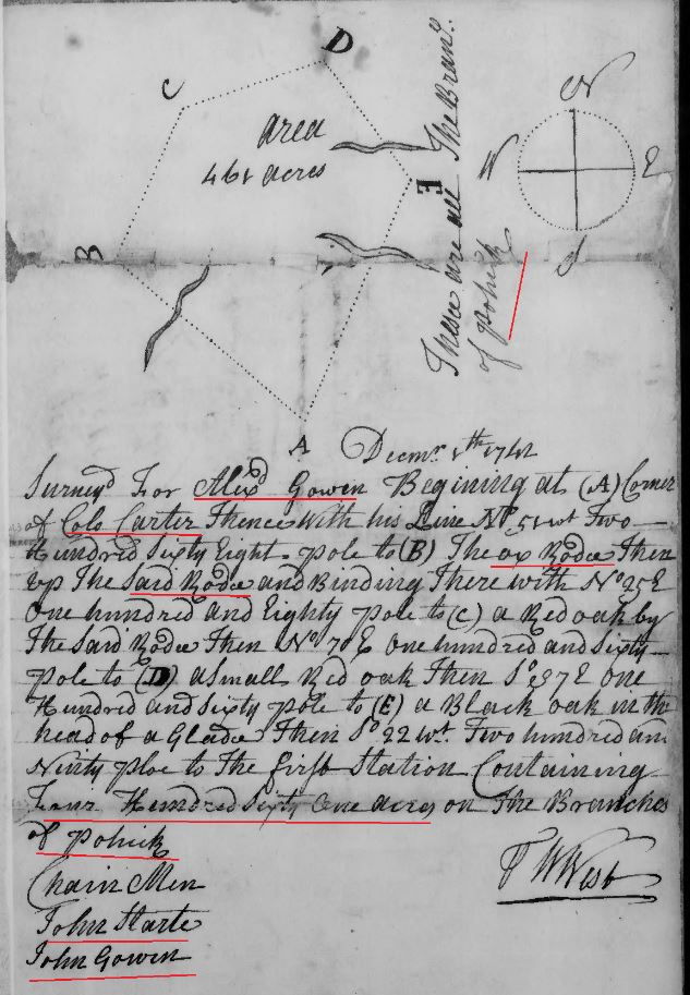
(Note: Only the index is available – Book N is missing – but it appears that eithere Alexander Gowen sold the above land prior to his decease in 1774/75 – and it was not recorded until after 1776 … or his estate sold the land to Richard Skinner some time between 1776-1784).
1776-1784 (likely when recorded) – Alexander Gowen to Richard Skinner, Deed bk N1, p 217, Fairfax Co, Va (Deed bk N1 is missing)
https://www.fairfaxcounty.gov/circuit/sites/circuit/files/assets/documents/pdf/hrc/deed-book-index-1742-1866-f-k.pdf
1776-1784 (likely when recorded) Alexander Gowen to Richard Skinner, Deed bk N1, p 218, Fairfax Co, Va (Deed bk N1 is missing)
https://www.fairfaxcounty.gov/circuit/sites/circuit/files/assets/documents/pdf/hrc/deed-book-index-1742-1866-f-k.pdf
1768 June 11 – Deposition of Benjamin Sebastian aged 62 p. 314-328 (1771 Howson Patent litigation, Carlysle v. Alexander)
… in the year 1731 he was imployed by Majr Robert Alexander grandfather to the Defendant to live in his Island as his overseer being the Island now held by Mr Phillip Alexander and this deponent lived there that year and was also imployd by the said Robert to receive his rents which the deponent did as far as lay in his power agreeable to a list delivered him by said Robert the names of the tenants being Judith Ballenger, James Going, Sarah Young, Sarah Amos below Four Mile Creek and Edward Chubb, Richard Middleton, William Boylstone, John Straughan, Adam Straughan, Edward Earpe and Richard Wheeler above the said creek where were all the tenants then living on the said Alexanders tract of land the bounds of which is now in dispute …
… as well as this deponent can remember that there was not at that time one tenant or house to the westward of the North line run on this survey except one small logd house side to be built by one John Lilliard who wa son-in-law to Chubb and before that time had lived with the said Chubb as this deponent understood by the neighbours …
… Deponent knows not where this deponent lived the year following with John Straughan and the year after that this deponent became a tenant to Alexander on promise of a lease which this deponent never got from said Alexander in his life, but after his death got a lease from Gerrard Alexander son to the said Robert to whom that part of the said land was divised by virtue of which lease this deponent now holds the plantations and lived thereon and in the neighborhood near 38 years …
… deponent never knew any of them to have any tenants on the west side of the North line run by the surveyor on this survey till one Robert Mills became a tenant to Gerrard Alexander tome time after the recovery made in the General Court by John and Gerrard Alexander agt Nathaniel Chapman, Awbrey and others and the land so least to Mills lay some part within the North line but the greatest part of it to the westward of that line …
… the deponent says that when John and Gerrard Alexander brought the first ejectment against Champan, Awbrey, etc, in the General Court they imployed John Mercer to prosecute the same as the informed this Deponent and this deponent served the ejectment on the person in possession among whom was one Mark Thomas overseer for Chapman …
… but when Mercer understood that Chapman was concerned he informed the Plaintiffs in that suit that he could not prosecute it against Chapman as he had been long retained or concerned in all said Chapmans business whereupon they rather than contend with Chapman or give up the said Mercer to plead the cause against them they agreed and gave Chapman their bond to reconvey to him whatever land they should take from him by their recovery in that suit all which was agreed to by Chapman and Mercer and Chapman declined making and defence as the said John and Gerrard Alexander informed this deponent and they recovered judgment in that suit against the several Defendants … for which Chapman was greatly complained of by some of the other Defendants who depended greatly on his management in the cause ….
… the Deponent says that ssometime in the Spring of the year 1733 Evan Thomas and his son William Thomas and one William McHoney came to Four Mile Run and settled and began to make a plantation on the North side of the said run and on the west side of the lower long branch and build one small logg’d house at which time there was not any other house on the land now claimed by the Plaintiff … except the small house said to be built by Lilliard as afsd that Evan Thomas soon after died and his widow removed up & maryed one Hugh Rigbey a shoe maker who after they built other houses made use of the logd house for a shop and continued to live there for several years …
… and this deponent never understood they or any of them were lookd upon themselves as tenants to the Alexanders but on the contrary has heard the said Evan Thomas in his lifetime say that Alexander had not any title to go further westward than the north line …
… Thomas had taken up his land jointly with one John Todd who survived him and it was never divided as this deponent heard of…
… some time in the year 1741 John and Gerrard Alexander, Philip Alexander of Stafford County, Bauldwin Dade and Townshend Dade were about to divide the said land agreeable to the will of Robert Alexander decd and got one Joseph Berry a surveyor to divide it …
… this deponent was with them and carried the chain … they run from Hunting Creek N 6 to divide by Gerrard Alexander and John Straughan marked a line after the surveyor did not run out the full number of poles because he did not run so far as the surveyor did on the present survey and it was agreed that the division then made should not be binding or conclusive of their back or north line exept the part of Phillip Alexander which lay off all within the due north line …
… he further saith that Gerrard Alexander in the year 1743 being a divised that his land was intailed resolved to try if he could dock the initial and procured a writ for that purpose and imployed on Robert Boggess to manage the matter for him and gave him a double loon as he Alexander informed this deponent …
… the day before the writ was executed John Alexander came up from Stafford and joined in the matter to have the intail of both their lands docked … (continues on pg 319) …
… the deponent being interogated as to Robert Boggess’s character says he thinks he is a bad man and is confirmed in his opinion by Boggess’s behaviour in a dispute between him and this deponent about four or five years ago when the said Boggess upon oath denyed many fees which this deponent had charged him with denying at the same time that there ever were such suits when the records and proceedings in those suits clearly manifested the contrary and the said Boggess then proved articles or charges in account against this Deponent which were disproved by a disinterested evidence so that this deponent thinks the said Boggess forsworn himself in many different instances in that settlement and this deponent thinks the referees who settled that account will also prove it …
… the deponent remembers there was a difference between Majr Robert Alexander in his lifetime and James Robertson account of Alexanders holding or pretending to hold three or four thousand acres of land more than his pattent specified which Robertson looking upon to be surplus land gave Alexander notice to enter it or he Robertson would do it as this Deponent was informed by Majr Alexander in his lifetime by his son John and by John Straughan who had lived long on the land as a tenant …
… but when Robertson found that Howsons pattent which Alexander claimed did not include all the land which Alexander pretended to claim he Robertson entered and took up part of it as was and Evan Thomas and John Todd had taken up part of it before and Francis Awbrey took almose all the residue being along Alexanders north line as near as they could which land so taken up by Thomas and Todd is now claimed by the Plaintiff and the said Thomas or Todd or those claiming under them hath always been in actual possession of it from the year 1733 to this time except the part recovered in the ejectment of Alexanders against Chapman, Awbrey, and others that James Robertson had run a small distance within Alexanders north line and took in about 30 acres of Alexanders land and sold one hundred and ninety five acres out of this tract to Capt Simon Pearson who devised it to his daughter Susanna who intermarried with John Alexander the Defendant’s father, who finding out that part of it lay within the north line of Howsons pattent sued Robertson in the General Court and recovered damages about L15 for so much of land as lay within the north line and did not eve pretend to ask damages for any more altho the whole 195 acres lay within the North 6 degrees west line by which the Alexanders divided …
(Continues on with evidence doubting the line extending to 17 degrees which is what the Alexanders claimed from pg 324-328)
… 20 odd years ago Ferdenando Oneal in a conversation with this deponent confessed that he was convicted for perjury and transported for that offence into this country …
… Deponent is very much surprised that Benjamin Talbot should know or pretend to know so much of the lands … as this deponent who has lived so long upon the land never heard of him till within this 3 or 4 years and never remembers to have seen him in his life to know him from any other man …
… the deponent says the entry made by Gerrard Alexander was after his suit brought against Awbrey …
.. he served the ejectment mentioned in the former part of his deposition on one Joseph Dorsey who lived below Four Mile Run upon the plantation now occupied by one Reedy and that the ejectment was also served upon several other persons who resided on the lands in this dispute & understood by serving that ejectment that ejectment that the Alexanders claied to the north 17degree west line that about 10 years ago this deponent made an entry in the proprietors office for 400 acres of land between the north 17degree west line of Alexander and the lines Robertson and Col Mason who claims Owsley’s pattent and having let the said Entry lye so long in the office this deponent was obliged in the month of Sept 1766 to renew it and obained a warrant and in July last he sold it to James Muir in trust for Robert Adam and John Carlyle the present plaintiff by assigning over his right of the said warrant …
… Straughan has often told this deponent that he thought that Alexander had not any right to go so far to the westward as their pattent did called for a north course …
… he further says that he understood that Awbrey who claimed Strutfields pattent by purchase was never interrupted till about one year ago by Col George Mason since he surveyed Owsley pattent under which he claims the deponent says that the surveyor in running the north 2degree west line from a hicory bush on Hunting Creek was to the westward of th marked trees and so angled them …
Land Records of Long Standing, 1742-1770. p. 314-328. Fairfax Co, Va
https://www.familysearch.org/ark:/61903/3:1:3Q9M-CSK4-D993-9?i=142&cat=193246
1768 June 11 – Deposition of William Boylstone aged 66 p. 310-314
… that upwards of 40 years ago he lived upon the lands of Majr Robert Alexander decd being the tract now in dispute with his this deponents father, and after this deponent married he removed from his father and became a tenant to said Alexander and lived as a tenant one year with Richard Middleton at the plantation where the present Robert Alexander now lives and that he paid rent for that year and Mr Sebastian collected the rents for Majr Alexander.
… this deponent cannot now recollect what year that was but remembers the year following the inspection law was in force.
… upwards of 40 years ago Majr Robert Alexander by one Joseph Berry a surveyor made a survey of the land now in dispute and that the surveyor frun from a hicory stump on Hunting Creek over Four Mile Run and along by where James Green now lives and stopt upon a levell near Awbrey’s Road leaving the place where James Green now lives to the left hand
… the Deponent further says that they run fro the end of that course down to the river and this deponent was in company and carried the chain some part of the way and did not see any line trees nor did he understand from Majr Alexander, Berry or any of the company they expected to see any but on the contrary seemed to agree there was no line trees
… he does not remember that then any persons settled at that time to the wastward of the long branch except one Doctor Dunghill who lived a considerable distance higher up Four Mile Run without the north 17 degree west line run upon this survey
… being interrogated by the deponent he says that about 40 years ago Robert Alexander run a course from a hicory stump on Hunting Creek which line run pretty near the two poplars on Four Mile Run
.. he always understood that Alexander claimed from the Wankapin Branch into the woods two miles and a quarter and that Alexanders tenants held a quarter of a mile upon the River and two miles and a quarter into the woods in their common way of talke
… one Whitford lived on the plantation where John Alexander now lives and that when Robert Alexander made that survey by Berry it was all woods and which survey included the place where John Alexander now lives.
… he has heard that the Awbreys run a lien near Chubbs Mill for Alexanders land 40 large odd years ago.
… Majr Robert Alexander run a course from the River to see where it intersected with his back course and that it overshot the place where the Road from Alexanderia to the Falls of Potomack now goes which said road crosses Brichins Branch but that none of the courses they then run ever went near the said Branch not within a quarter mile in this deponents opinion Strutfield saith they run to the River or from it at that time from a place about half a mile below the place where George West began to survey fro the beginning on this survey which beginning is near opposite the lower end of Mason’s Island.
… he always understood that Alexanders corner on Hunting Creek was a hicory
… when Majr Robert Alexander surveyed with Berry he did not mark any trees.
… he never heard that Alexanders line run by Chubbs Mill
… he understood from Majr Alexanders tenants that Alexanders land run from the River where Robert Alexander now lives into the woods two mile and better
… Chubb lived about 10 yards from his Mill
… Stephen Gray who was a tenant to Robert Alexander said that he claimed from the River two miles and a quarter into the woods and that the said Gray lived when Robert Alexander now lives
… course Berry run for Alexanders line … as far as he understood the Run North 9 degree west and that the Tenants paid 524 pounds of tobacco for rent for a single lot of 100 acres … those who held double lots of 200 acres paid 1048 and this deponent paid 524 pounds of tobacco as he held part of Middletons lot who claimed a double lot.
… about the time he held the tenants talk about their ? none of them had then cleared a mile from the River.
… there was no path leading as the Road from Alexandria to the Falls of Potomack now goes till within this 12 or 13 years past, that people before that time when they came down towards Hunting Creek they came round near a place called the hoe or hoehill and further saith not.
Signed: William Boylstone
Fairfax. This deposition was taken in the presence of the parties the 11th day of June 1768 who declares he has attended 11 days certified under our hands. John West, William Adams.
Land Records of Long Standing, 1742-1770. p. 310-314. Fairfax Co, Va
https://www.familysearch.org/ark:/61903/3:1:3Q9M-CSK4-D993-F?i=140&cat=193246
1768 Nov 21 – Court held Nov 21, 1768. John Hollis, Dec’d Sale of Estate recorded. Esther Hollis, Admr. [Transcript] Fairfax Court Order Book for 1765 p. 57, http://files.usgwarchives.net/va/fairfax/court/etal554gwl.txt
1768 Nov 21 – Court held Nov 21, 1768. John Hollis Dec’d, Estate Account. [Transcript] Fairfax Court Order Book for 1765 p. 58, http://files.usgwarchives.net/va/fairfax/court/etal554gwl.txt
1769 Apr 18 – James Gowing v. Thomas Awbrey Exr of Francis Awbrey dec’d} In Chancery Est
On hearing the Bill and Answer the injunction is dissolved and it is decreed and ordered that the Deft be at liberty to take his execution on his judgment at law against the complainant and that the complainant do pay to the Defendant his costs by him in this suit expended.
Order book, 1768-1770 – Fairfax Co, Va. p. 126.
https://www.familysearch.org/ark:/61903/3:1:3Q9M-CSY6-P96L-P?i=73&cat=193222
1770 – Alexander Going
Census: rent rolls, 1770, , Fairfax, Virginia, USA. 5
Fairfax Co, Va
http://search.ancestry.com/cgi-bin/sse.dll?db=vacen&h=32844708&indiv=try&o_vc=Record:OtherRecord&rhSource=3566
1772 – Alexander Gowin –
Census: rent rolls, 1772, , Fairfax, Virginia, USA. 5 http://search.ancestry.com/search/db.aspx?dbid=3578&enc=1
Virginia, Compiled Census and Census Substitutes Index, 1607-1890
Name:Alexander Gowin [Sr. or Jr.?]
Fairfax Co, Va.
1774 Alexander Goings
Rent Rolls of Fairfax County, Va
Fairfax Co, Va.
http://interactive.ancestry.com/49017/FLHG_AbstWilInvFairfaxCntyVA-0005?backurl=http%3a%2f%2fsearch.ancestry.com%2fsearch%2fdb.aspx%3fdbid%3d49017%26path%3d&ssrc=&backlabel=ReturnBrowsing#?imageId=FLHG_AbstWilInvFairfaxCntyVA-0048
1774 – Alexander Going –
Census: rent rolls, 1774, Fairfax, Virginia, USA. http://search.ancestry.com/search/db.aspx?dbid=3578&enc=1
Virginia, Compiled Census and Census Substitutes Index, 1607-1890
Name:Alexander Going [Sr. or Jr.?]
Fairfax Co, Va
http://interactive.ancestry.com/49017/FLHG_AbstWilInvFairfaxCntyVA-0051?backurl=http%3a%2f%2fsearch.ancestry.com%2fsearch%2fdb.aspx%3fdbid%3d49017%26path%3d&ssrc=&backlabel=ReturnBrowsing#?imageId=FLHG_AbstWilInvFairfaxCntyVA-0048
1774 Feb 25 Going Lamphier – George Mason, George Washington
, same page with George Washington, and George Mason
Pohick Church – in Lorton, Virginia
Truro Parish Colonial Vestry Book
(Church/Vestry of George Washington, George Mason, and other patriots)
Truro Parish, Va.
Pohick Church – in Lorton, Virginia
Truro Parish Colonial Vestry Book
Truro Parish, Va.
http://www.pohick.org/vestrybook.html p.160
1776-1784 (likely when recorded) – Alexander Gowen to Richard Skinner, Deed bk N1, p 217, Fairfax Co, Va (Deed bk N1 is missing)
https://www.fairfaxcounty.gov/circuit/sites/circuit/files/assets/documents/pdf/hrc/deed-book-index-1742-1866-f-k.pdf
1776-1784 (likely when recorded) Alexander Gowen to Richard Skinner, Deed bk N1, p 218, Fairfax Co, Va (Deed bk N1 is missing)
https://www.fairfaxcounty.gov/circuit/sites/circuit/files/assets/documents/pdf/hrc/deed-book-index-1742-1866-f-k.pdf
1782 – Joseph Going – head of a household of seven “whites over 16” in the 1782 census of Fairfax County, page 17, according to “Heads of Families, Virginia, 1790.”
Fairfax Co., Va. 1782 – Virginia, Compiled Census and Census Substitutes Index, 1607-1890
Name: Joseph Going
State: VA
County: Fairfax County
Township: 07 00
Year: 1782
Record Type: Continental Census
Page: 17
Database: VA Early Census Index
Ancestry.com. Virginia, Compiled Census and Census Substitutes Index, 1607-1890 [database on-line]. Provo, UT, USA: Ancestry.com Operations Inc, 1999.
https://search.ancestry.com/cgi-bin/sse.dll?indiv=1&dbid=3578&h=32836634&tid=&pid=&usePUB=true&_phsrc=kUu4561&_phstart=successSource ; 1782 – Joseph Going – Virginia Census – head of a household of seven “whites over 16” in the 1782 census of Fairfax County, page 17, according to “Heads of Families, Virginia, 1790.” 7 whites, no blacks in household. Fairfax Co., Va.
http://www2.census.gov/prod2/decennial/documents/1790m-02.pdf
1782 Nov 10 – Maryland, Compiled Marriages, 1655-1850
Name: Eleoner Going
Gender: Female
Marriage Date: 10 Nov 1782
Spouse: John Chandler
Spouse Gender: Female
County: Charles County
Ancestry.com. Maryland, Compiled Marriages, 1655-1850 [database on-line]. Provo, UT, USA: Ancestry.com Operations Inc, 2004.
https://search.ancestry.com/cgi-bin/sse.dll?indiv=1&dbid=7846&h=86342&tid=&pid=&usePUB=true&_phsrc=kUu4627&_phstart=successSource
1783 – Joseph Going – Virginia Census – head of a household of seven “whites over 16” in the 1782 census of Fairfax County, page 17, according to “Heads of Families, Virginia, 1790.” 7 whites, no blacks in household. Fairfax Co., Va.
http://www2.census.gov/prod2/decennial/documents/1790m-02.pdf
1784 Personal tax list Fairfax County, Va
Jenny Gowns 5 cattle (image 9)
Joseph Going 1 over 21 white male, 1 cattle
http://www.binnsgenealogy.com
1785 Personal tax list Fairfax County, Va
Joseph Going 1 tithe over 21 yrs, 2 horses, 2 cattle (image 3)
http://www.binnsgenealogy.com
1785 Sept 24 – Richard Burke v. James Gowin} Trespass assault and battery
The suit is dismissed.
Arlington Co, Va – Order book, 1780-1787. p. 183
https://www.familysearch.org/ark:/61903/3:1:3QHV-J36N-W68M?i=112&cat=332450
1786 personal property tax list Fairfax Co, Va
Joseph Gavin 1 tithe over 21 yrs, 2 horses (image 9)
http://www.binnsgenealogy.com
1787A personal property tax list Fairfax Co, Va
Joseph Gowing 1 tithe, 2 horses, 2 cattle (image 9)
http://www.binnsgenealogy.com
1787 March 21 – Johnston Gowen v William Sanford} Trespass assault & battery
The suit is dismissed.
Order book, 1783-1788 – Fairfax Co, Va p. 353
https://www.familysearch.org/ark:/61903/3:1:3Q9M-CSY6-P9XS-L?i=567&cat=193222
1788A personal property tax list Fairfax Co, Va
Joseph Going 2 white tithes (Jos Going, Johnson Going), 2 horses (image 10)
http://www.binnsgenealogy.com
1789B personal property tax list Fairfax Co, Va
Joseph Going 2 white tithes (J. Going, Jno Going), 2 horses (image 7)
http://www.binnsgenealogy.com
1789 Fairfax County, Va – Personal Tax Lists with John Going and Joseph Going: 
1789 Fairfax Co, Va Personal Tax List with R Gowns and D Gowns: 
1789 September 22, page 26 FAIRFAX COUNTY ROAD ORDERS 1749-1800
On the road from the Turnpike Gate at the intersection of the George Town Road to the White Oak at the Widow Tucker’s – the tithables which now are, &c . of Joseph Carroll, Joseph Gowing, Carlyle’s Farm, Ramsay’s Quarter, John Ellis, Robert Sanford, Fielden Isaac, Guy Evans, John Violett, Wm. Hy Terrett, Mrs. West, Daniel McAlister, John Hawkins, Wm. Herbert’s Quarter, Thos Daniel, Widow Tucker, James Webb, Dade’s old Quarter, Chas Curtis’s place, Geo. Solomon, Samuel Bowling, Wm. Bowling, Elisha Harden, Wm. Lyles, James Kenny, Patty Moxly, Fitzgerald’s Quarter, and all those living on the land formerly Townshend Dade’s and Charles Alexander’s, on the west of the west of the George Town Road, and also all those living on the Land of Thos & John West, between the turn pike road and the road leading to Colchester, Joel Cooper, Robert Adam’s plantation. John Geesling, as last.
http://www.smitherman.net/documents/fccob.pdf
1790A personal property tax list Fairfax Co, Va
Joseph Going 1 tithe, 3 horses (image 7)
http://www.binnsgenealogy.com
1791B personal property tax list Fairfax Co, Va
Joseph Going 2 white tithes (J. Going, Jo. Going Jun), 3 horses (image 7)
http://www.binnsgenealogy.com
1792A personal property tax list Fairfax Co, Va
Joseph Going 3 white tithes (J. Going, Jno Going, Jo. Going Jun), 4 horses (image 8)
http://www.binnsgenealogy.com
1793B personal property tax list Fairfax Co, Va
Joseph Going 1 white tithe, 3 horses
http://www.binnsgenealogy.com
1793, Joseph Goins was a resident of Fairfax County, Virginia where a daughter was born.” Fairfax Co, Va.
1793 Virginia Jane “Gincie” Goins daughter of Joseph Goins and Millie Loving Goins, was born in 1793 in Fairfax County, according to William P. Grohse. She was married about 1822 to Solomon Dickinson Collins who was born in Wilkes County, North Carolina in 1799. He was the son of a Revolutionary soldier, Solomon Collins and his wife Edy Dickinson Collins. Solomon Collins was born in Cumberland County, Pennsylvania in 1760. Solomon Dickinson Collins appeared in the 1830 census with nine members in his household. He appeared on the 1836 tax list of Hawkins County, Tennessee. Solomon Dickinson Collins was enumerated as the head of household in the 1840 census of Hawkins County: “Collins, Solomon white male 40-50 white female 40-50 white male 10-15 white male 10-15 white male 5-10 white male 5-10 white female 0-5 white female 0-5”
Fairfax Co, Va.
1794A personal property tax list Fairfax Co, Va
Daniel Gown 1 tithe (image 8)
Joseph Going 2 tithes (Jos Going, Jos Going Jr), 3 horses (image 8)
http://www.binnsgenealogy.com
1795B personal property tax list Fairfax Co, Va
Daniel Gown 1 tithe (image 7)
Joseph Going 3 tithes (Jno Going, Jos Going, Jos Going Jr), 3 horses (image 7)
http://www.binnsgenealogy.com
1795 July 21 – Dennis Foley, Caven Boa, and Lanty Crowe, bound unto William Dencale, Richard Ratliff, Thomas Gwinell, and John Jackson gentlemen justices of the county court of Fairfax. Dennis Foley is administrator of the Estate of Daniel Gowings decd. Inventory ordered. Daniel Gowen admin bond Will Books, Vol G1-I1, 1794-1806. Will Book G1, 1794-1799: pg 104 Fairfax Co, Va. 1795 – Daniel Gowens – Admin Bond, bk G1, p 104, Fairfax Co, Va
https://www.familysearch.org/ark:/61903/3:1:3QS7-89PC-QNZ1?i=65&cat=193261
1795 Sept 21 – Daniel Gowen decds inventory filed with court. Signed: John Ball, Samuel Shreve, and William Thrift. Will Books, Vol G1-I1, 1794-1806. Book G1, 1794-1799: pg. 113. Fairfax Co, Va. 1795 – Daniel Gowens – Inventory, Will bk G1, p 113, Fairfax Co, Va
https://www.familysearch.org/ark:/61903/3:1:3QS7-89PC-QN81?i=69&cat=193261
1796A personal property tax list Fairfax Co, Va
Joseph Going 1 tithe, 5 horses (image 6)
http://www.binnsgenealogy.com
1796 Sept 19 inventory for estate of Daniel Gowen recorded. Return signed by John Ball, William Thrift, Samle Shreve. Will Books, Vol G1-I1, 1794-1806. Book G1, 1794-1799: pg. 192. Fairfax Co, Va. 1795 – Daniel Gowens – Inventory, Will bk G1, p 192, Fairfax Co, Va
https://www.familysearch.org/ark:/61903/3:1:3QS7-89PC-QNQC?i=109&cat=193261
1796 Aug 14 – Virginia, Compiled Marriages, 1660-1800
Name: Caty Gowan
Spouse: Peter Weltz
Marriage Date: 14 Aug 1796
Marriage Location: Fairfax County, Virginia
Dodd, Jordan. Virginia, Compiled Marriages, 1660-1800 [database on-line]. Provo, UT, USA: Ancestry.com Operations Inc, 1997.
https://search.ancestry.com/cgi-bin/sse.dll?indiv=1&dbid=3002&h=10226&tid=&pid=&usePUB=true&_phsrc=kUu4611&_phstart=successSource
1796 Alexandria Va Tax Lists
March 28/29
Alexander Gowen 1 white, 1 slave abv 12
John Gowen 1 white
https://www.familysearch.org/ark:/61903/3:1:3Q9M-CS79-1L7?i=144&cat=696432
1797B personal property tax list Fairfax Co, Va
Joseph Going 1 tithe, 5 horses (image 5)
http://www.binnsgenealogy.com
1797 – Birth year – Virginia, Deaths and Burials Index, 1853-1917
Name: Hannah Goings
Birth Date: abt 1797
Birth Place: Fairfax, Virginia
Death Date: 26 Jul 1891
Death Place: Alexandria, Virginia
Death Age: 94
Race: Colored (Black)
Marital status: Married
Gender: Female
Spouse Name: Jno. Goings
FHL Film Number: 2048588
Ancestry.com. Virginia, Deaths and Burials Index, 1853-1917 [database on-line]. Provo, UT, USA: Ancestry.com Operations, Inc., 2011.
https://search.ancestry.com/cgi-bin/sse.dll?indiv=1&dbid=2558&h=575118&tid=&pid=&usePUB=true&_phsrc=kUu4624&_phstart=successSource
1798A personal property tax list Fairfax Co, Va
Richard Gowen 1 white tithe over 16 years, 1 black tithe above 16 (image 6)
http://www.binnsgenealogy.com
1798B personal property tax list Fairfax Co, Va
Joseph Going 1 white tithe, 4 horses (image 6)
http://www.binnsgenealogy.com
1798 Alexandria Va Tax Lists
March 23
John Gowen 1 white
https://www.familysearch.org/ark:/61903/3:1:3Q9M-CS79-127?i=171&cat=696432
1798 Aug 8 – Caty Gowan was married August 8, 1796 to Peter Weltz, ac, according to “Fairfax County, Virginia Marriages, 1759-1800.”
1799A personal property tax list Fairfax Co, Va
Joseph Going 2 white tithes, 4 horses (image 5)
Richard Going 1 white tithe, 1 black tithe above 16 (image 5)
http://www.binnsgenealogy.com
1800B personal property tax list Fairfax Co, Va
Joseph Going 1 white tithe, 2 horses (image 5)
Richard Going 1 white tithe, 1 black tithe (image 5)
http://www.binnsgenealogy.com
1802B personal property tax list Fairfax Co, Va
Richard Going 2 white tithes, 1 black tithe (image 6)
Joseph Goines (or Gaines maybe) 2 white tithes, 2 black tithes, 6 horses (image 6)
http://www.binnsgenealogy.com
1803A personal property tax list Fairfax Co, Va
Richard Gowing 1 white tithe, 2 horses (image 6)
http://www.binnsgenealogy.com
1804B personal property tax list Fairfax Co, Va
Richard Going 1 white tithe, 2 horses (image 5)
http://www.binnsgenealogy.com
1805A personal property tax list Fairfax Co, Va
Richard Going 1 white tithe, 2 horses (image 6)
http://www.binnsgenealogy.com
1806 – Peter Wise Jr v Ball …Trespass case.
… Peter Wise Jr and George Wise v. John Ball and Mariann his wife…
Land leased out for …. term of 30 years … in County of Alexandria called Abdington … under a lease from Walten and Alexander and Catherine his wife to your orators … except parts in the possession of William Frazer, John Ball and Marianne his wife, late Marianne Bowling, and of a certain Joseph Going … John Ball and Marianne his wife … cut and carry away wood and timber from the land so leased to your orator… Arlington Co, Va
https://www.lva.virginia.gov/chancery/case_detail.asp?CFN=013-1810-047
1810 US Census in Fairfax Co, Va
Name: Joseph Going
Home in 1810 (City, County, State): Fairfax, Virginia
Free White Persons – Males – Under 10: 1
Free White Persons – Males – 26 thru 44 : 1
Free White Persons – Females – Under 10: 1
Free White Persons – Females – 16 thru 25: 1
Free White Persons – Females – 26 thru 44: 1
Numbers of Slaves: 1
Number of Household Members Under 16: 2
Number of Household Members Over 25: 2
Number of Household Members: 6
https://search.ancestry.com/cgi-bin/sse.dll?_phsrc=PXv2353&_phstart=successSource&usePUBJs=true&indiv=1&dbid=7613&gsln=Going&cp=12&msypn__ftp=fairfax,%20virginia,%20usa&msypn=998&msypn__ftp_x=1&msypn_x=1&new=1&rank=1&redir=false&gss=angs-d&pcat=35&fh=0&h=816646&recoff=7&ml_rpos=1
1810 US Census in Fairfax Co, Va
Name: George Goings
Home in 1810 (City, County, State): Fairfax, Virginia
Number of All Other Free Persons: 8
Number of Household Members: 8
https://search.ancestry.com/cgi-bin/sse.dll?_phsrc=PXv2353&_phstart=successSource&usePUBJs=true&indiv=1&dbid=7613&gsln=Going&cp=12&msypn__ftp=fairfax,%20virginia,%20usa&msypn=998&msypn__ftp_x=1&msypn_x=1&new=1&rank=1&redir=false&gss=angs-d&pcat=35&fh=1&h=816655&recoff=7%2021&ml_rpos=2
1810 US Census in Fairfax Co, Va
Name: Richard Goings
Home in 1810 (City, County, State): Fairfax, Virginia
Free White Persons – Males – 10 thru 15: 1
Free White Persons – Males – 16 thru 25: 1
Free White Persons – Males – 45 and over: 1
Free White Persons – Females – 45 and over : 1
Numbers of Slaves: 1
Number of Household Members Under 16: 1
Number of Household Members Over 25: 2
Number of Household Members: 5
https://search.ancestry.com/cgi-bin/sse.dll?_phsrc=PXv2353&_phstart=successSource&usePUBJs=true&indiv=1&dbid=7613&gsln=Going&cp=12&msypn__ftp=fairfax,%20virginia,%20usa&msypn=998&msypn__ftp_x=1&msypn_x=1&new=1&rank=1&redir=false&gss=angs-d&pcat=35&fh=2&h=816686&recoff=7&ml_rpos=3
1815 March 30 – Philip Alexander v. William Henry Washington & etc.
Deposition of Joseph Goings of lawfull age.
Taken at Mr Burches house ….
Question: Do you know Philip Alexander? And how long have you known him, state all you know of his understanding, habits and manners.
Answer: That he has lived in Mr Lukes family nearly 1 years. That during that time he know Phill and all his relations and thinks him Phill an Idiot – that all Phill’s relations thought him an Idiot and his mother & William Washington told the Deponant that he Phill was a poor weak creature and unabe to do anything for himself or anyone else – that he is not capable of taking care of himself or estate – that Wm Washington his father in law manages his business.
Virginia Chancery Index. 1821-012. Arlington County, Virginia (image 144)
https://www.lva.virginia.gov/chancery/
1815 March 30 – Philip Alexander v. William Henry Washington & etc.
Deposition of Benjamin Goings of lawful age.
Taken at Thomas Burche’s Tavern by consent of parties …
Question: Do you know, and are you acquainted with Philip Alexander? If you do, state what you know of his understanding, habits and manners – and all you know of him.
Answer: That he was born near where Phill was born and that he has known him all his life. That he has worked on the farm belonging to Phill for near 10 years. That he thinks him incapable of managing a farm or taking care of himself. That he thinks him much more ignorant than a child of 9 years of age. That he has never seen anyone of so little forethought. He the deponent declares that Phill suffered Mr Luke to take his estate and enjoy the profits thereof. He also says that Mr Luke sold a boy named Lewis that he cut his (Phil’s) wood down and sold it. The deponent also says that Phill although he has been farming all his life, knows nothing at all about it, that he does not know how to make anything on a farm – that he cannot work and would harm if he was not supported.
Virginia Chancery Index. 1821-012. Arlington County, Virginia (image 146)
https://www.lva.virginia.gov/chancery/
1815 April 1 – Philip Alexander v. William Henry Washington & etc.
Deposition of Mary Goings Senr of full age.
Taken at Thomas Burche’s tavern in a suit in Chancery …
Question: Do you know, and are you acquainted with Philip Alexander? State what you know of his understanding, habits and manners – and all you know of him.
Answer: That she has known Philip Alexander ever since he went to schoool. That she has always thought him an Idiot and now think him one – that all Philip’s relations have told her and even his own mother that he was born an idiot, that she was well acquainted with his father and mother during Philips whole life.
Signed: Mary Goings
Virginia Chancery Index. 1821-012. Arlington County, Virginia (image 128)
https://www.lva.virginia.gov/chancery/
1815 April 1 – Philip Alexander v. William Henry Washington & etc.
Deposition of Mary Goings (Jr) of full age.
Taken at Thomas Burches tavern in a suit in Chancery …
Question: Do you know and are you acquainted with Philip Alexander? State what you know of his understanding, habits and manners, and all you know of him.
Answer: That she has not been long acquainted with Philip Alexander, that from the short acquaintance she has had with him, she clearly saw that he was an Idiot and not capable of taking care of his property or himself, and this appears to be the sentiments of the neighborhood – and further saith not.
Signed: Mary Goings
Virginia Chancery Index. 1821-012. Arlington County, Virginia (image 142)
https://www.lva.virginia.gov/chancery/
1819 April 19 – Philip Alexander v. William Henry Washington & etc.
Deposition of Joseph Gowen taken this 19th April 1819 at the Court House in the Town of Alexandria in ursuance of the annexed commission & notice …. in the Chancery side of the United State Circuit Court of the District of Columbia for the County wherein Philip Alexander is complainant and Thomas L Washington and William Brent are Defts.
Question: Do you know Philip Alexander the complainant? If you do state how long you have known him and all you know of his understanding and capacity to do business and all you know about him.
Answer (by Joseph Gowen): I have known Philip Alexander ever since he was a boy & used to go to school with him. After he grew up to be a man I lived with John Luke and drove a team for him & at that time Philip Alexander & John Luke lived together. I always thought him foolish & never knew him to do any business nor to make any bargain. After when I have offered to make purchases from him, he has referred me to his brothers, John Luke, & William Henry Washington, and to his mother Mrs Washington.
Signed: Joseph Gowen.
Wit: P R Tendall
Sworn to before us this 19th April 1819.
Virginia Chancery Index. 1821-012. Arlington County, Virginia (image 57)
https://www.lva.virginia.gov/chancery/
1817 Dec 15 – Richard Gowin will . . . names wife Elizabeth, friend Sarah Frizzel, friend Sebastian McPherson executor. Signed: Richard Gowen. Wits: Jos Blinco, Jane Frizzel. Proved up in court on Jan 19, 1818 by Sebastian McPherson. Will Books, Vol J1-M1, 1806-1822. 1816-1820: pg. 179. Fairfax Co, Va. https://www.ancestry.com/interactive/9085/007644613_00473?pid=149414&backurl=https://search.ancestry.com/cgi-bin/sse.dll?indiv%3D1%26dbid%3D9085%26h%3D149414%26tid%3D%26pid%3D%26usePUB%3Dtrue%26_phsrc%3DTqH759%26_phstart%3DsuccessSource&treeid=&personid=&hintid=&usePUB=true&_phsrc=TqH759&_phstart=successSource&usePUBJs=true#?imageId=007644613_00563
1818 March 16 inventory return filed. – In Jan 1818, Thomas Dickey, Philip Casper, William Wiley, and Nathaniel Barker ordered to do an inventory on estate of Richard Gowin decd. R 185. Fairfax Co, Va. https://www.ancestry.com/interactive/9085/007644613_00473?pid=149414&backurl=https://search.ancestry.com/cgi-bin/sse.dll?indiv%3D1%26dbid%3D9085%26h%3D149414%26tid%3D%26pid%3D%26usePUB%3Dtrue%26_phsrc%3DTqH759%26_phstart%3DsuccessSource&treeid=&personid=&hintid=&usePUB=true&_phsrc=TqH759&_phstart=successSource&usePUBJs=true#?imageId=007644613_00566
1820 US Census in Fairfax County, Virginia
Name: George Goings
Home in 1820 (City, County, State): Truro Parish, Fairfax, Virginia
Enumeration Date: August 7, 1820
Free Colored Persons – Males – 14 thru 25: 1
Free Colored Persons – Males – 45 and over: 2
Free Colored Persons – Females – Under 14: 1
Free Colored Persons – Females – 14 thru 25: 1
Free Colored Persons – Females – 45 and over: 1
Number of Persons – Engaged in Agriculture: 1
Total Free Colored Persons: 6
Total All Persons – White, Slaves, Colored, Other: 6
https://search.ancestry.com/cgi-bin/sse.dll?indiv=1&dbid=7734&h=1083717&tid=&pid=&usePUB=true&_phsrc=PXv2356&_phstart=successSource
1840 US Census:
Name: Hannah Goins
Home in 1840 (City, County, State): Fairfax, Virginia
Free Colored Persons – Males – Under 10: 1
Free Colored Persons – Males – 24 thru 35: 1
Free Colored Persons – Females – Under 10: 2
Free Colored Persons – Females – 10 thru 23: 1
Persons Employed in Agriculture: 4
Total Free Colored Persons: 5
Total All Persons – Free White, Free Colored, Slaves: 5
Year: 1840; Census Place: Fairfax, Virginia; Roll: 558; Page: 172; Family History Library Film: 0029686
https://search.ancestry.com/cgi-bin/sse.dll?indiv=1&dbid=8057&h=3484284&tid=&pid=&usePUB=true&_phsrc=kUu4588&_phstart=successSource
))))))))))))))))))))))))))))))))))))))))))))))))))))))))))))))))))))))))))))))))))
HOWSON PATTENT LITIGATION:
What was at stake? The following map is not exact (didn’t have my protractor out) so just an estimation based on the claims made. I have marked the map below with A, F, D, and E. The dispute was about how the line went from the known point on the Southwest portion of the Alexander land. Directly North leads to E. 6 degrees West leads to point D, 15 degrees West leads to point F. 17 degrees West leads to point A (letters in red).
A survey was done in 1741 showing the following land if the line went directly North (E). It showed that directly North that the Alexanders had 6562 acres of land. Their original Howson patent said it was supposed to be 6000 acres. The Alexanders were claiming that the line went 17 degrees west to point (A) – which would have given them at least another 4000+ acres of land (approximately). It would have taken a majority of the Carlyle land, all of the Chapman and Awbrey land (marked in yellow – this was the Thomas and Todd land they had purchased from Thomas Going, John Going, William Going and James Going), and it would have taken several other people’s land that they had held for over 40-50 years in many cases:
With line heading directly north – this gives the following acreage to the Alexander Family for the Howson pattent:
1) Mr Gerrard Alexander 2959 acres
2) John Alexander 1421 acres
3) Townshend Dade land 400 acres
4) Baldwin Dade land 400 acres
5) John Alexander and Hugh West 220 acres
6) Harry ? 200 acres
7) Cpt Phillip Alexander 500 acres
8) Holmes Island 302 acres
9) Pearson’s Island 160 acres
TOTAL Acres: 6562 acres with line going directly North to point (E) accounted for in below map – today’s estimates place the area at 8000 acres. They were attempting to add another 50-60% to their patent by having an “undefined” back line.

In 1771 Carlyle won his case and the court ejected Alexander from Carlyle’s land. They held that the survey should go to point E on the map above (directly North). Unfortunately, when looking up the Howson litigation involving the Alexander family, researchers always seem to claim the Alexander family “won” the cases. This could not be further from the truth. They lost the case. They ended up getting what they originally were granted – but they were attempting to almost double their land size by illegally seizing other people’s property and claiming their back line was “undefined” and allowed them to do so.
The Alexander family received the 6000 acre Howson patent in 1669 and never appeared to file a survey. They used this fact to claim the land description in their Deed actually extended beyond the actual plat, and were successful in several occasions in ejecting people from land they had owned, at times for decades. This “undefined” back line allowed the Alexanders to act in a predatory way to swoop in and take land behind their back line whenever they wanted to extend their property holdings.
The first survey that eventually made its way into court was in 1741 where the options of a direct north back line, a 6 degree west back line, and a 15 degree west back line were drawn for the court. This survey was used in later court cases in 1771 involving John Carlysle, and in 1809-1814 case involving Parthenia Dade (an Alexander daughter who had married into the Dade family).
1771 case in Fairfax Co, Va: AMINIDAL SEEKRIGHT (tenant of Carlysle) & JOHN CARLYSLE v. CHARLES ALEXANDER
(Facts of Case: John Carlysle had leased 800 acres of land on his property to Aminidal Seekright for 7 years on May 21, 1766. Aminidal Seekright then arrived at the 800 acre farm on May 23, 1766. Charles Alexander sent in one of his “employees”, a Mr. Timothy Dreadnaught to “by force of arms” remove Aminidal Seekright and eject him from the land. Charles Alexander was claiming the land was his. Aminidal Seekright resisted and remained on the land and brought suit. John Carlysle joined in the suit as it had to do with his property line).
Finding of Jury and Court against Charles Alexander:
The jury sworn to try the issue in this cause returned into Court and upon their oath say that the artificial bounds of Alexander’s land are from red C on Hunting Creek to black E, and thence to the mount of Wancopin branch at Black A, laid down in the surveyors plat returned in this cause and that the Defendant is guilty in manner and for as the Plaintiff against him hath complained and they do assess damages (crease in page cant read rest of line) … shilling besides his costs. Therefore it is considered by the Court that the Plaintiff recover against the Deft his term yet to come of and in the messuage or a tenement and lands with the appurtenancy in the declaration mentioned together with his damages aforesaid in form aforesaid assessed, and his costs by him about his suit in this behalf expended. and the said Deft may be taken and whereupon the Plt pray the writ of our Lord the King to the Sheriff of the said County of Fairfax to be directed to cause him to have his possession of his term aforesaid yet to come and to him it is granted returnable here.
Unfortunately the Alexanders kept up their shennanigans and actually won a few cases, ejecting rightful owners from their land. In 1809 they attempted to do this to a family member – and the US Supreme Court eventually found against the Alexander family in an 1814 case with Chief Justice Marshall issuing the following opinion AGAINST the Alexander family’s claim that their patent extended west any degrees in their attempts to confiscate other people’s lands:
1814 Case – ALEXANDER v. PENDLETON
12 U.S. 462
8 Cranch 462
3 L.Ed. 624
ALEXANDER AND OTHER
v.
PENDLETON.
March 12, 1814
THIS was an appeal from the Circuit Court of the district of Columbia, sitting at Alexandria, as a Court of Equity.
The case, as stated by MARSHALL, Ch. J. in delivering the opinion of the Court, was as follows:
This suit was brought in the year 1806, in the Circuit Court for the county of Alexandria, for the purpose of quieting the title of Nathaniel Pendleton, the Plaintiff in that Court, to 83 acres of land contiguous to the town of Alexandria which have been in his possession, and in the possession of those under whom he claims, from the year 1732 to the present time.
Robert Alexander, being seized of a large tract, on part of which the town of Alexandria now stands, on the 17th of January in the year 1731-2, executed to Dade Massey, then about to intermarry with his daughter Parthenia Alexander, his bond in the penalty of 800l. with a condition that he would convey to his daughter Parthenia and her heirs, on demand, four hundred acres of land lying on Potomac, ‘beginning on the river side and from thence running to his back line, making a long square so as to have the same breadth on the river as on the back line.’
The marriage soon afterwards took effect, and she was put into possession of the land by the following bounds, that is to say: ‘Beginning at the mouth of Goings gut, on the river Potomac, and extending down the river so as to include four hundred acres of land between the river and the back line.’
The back line called for in the patent was a due north course; that by which Robert Alexander then held was north 6 west. Claims have been since successfully asserted which would vary the back line so as to run north 17 west. The Appellants insist that those who hold under Parthenia shall be compelled to extend to the back line, as now established, and proportionably to contract their line down the river, so that the parallelogram shall still comprize four hundred acres. Pendleton, who is a purchaser under Parthenia, insists on being limited on the west by the line north 6 west, which was the back line when the title of Parthenia accrued.
In the year 1735, Robert Alexander departed this life, having first made his last will in which he devised as follows: ‘Item, I give to my daughter Parthenia Massey four hundred acres in Prince William county, according to my bond. Item, I give to my daughter Sarah Alexander, four hundred acres joining Parthenia Massey, the same length on the back line and the same breadth on the river.’
Parthenia survived her husband, Dade Massey, and intermarried with Townshend Dade. Sarah intermarried with Baldwin Dade, and was put into possession of the land devised to her.
John and Gerard Alexander were the only sons of Robert, and were the co-devisees of the bulk of his estate. In April, 1740, John instituted a suit against Gerard for partition; and to this suit Townshend Dade and Parthenia, his wife, and Baldwin Dade and Sarah, his wife, were parties Defendants. A decree of partition was made, directing that the lands of the Dades also should be allotted to them to be held in severalty. Commissioners were appointed to execute this decree, with directions to report their proceedings to the Court.
Under this interlocutory decree the land was surveyed by Joseph Berry, and a division made. Four hundred acres were allotted to Townshend Dade and Parthenia, his wife, and the same quantity to Baldwin Dade and Sarah, his wife. This allotment was made on the idea that north 6 west was the true back line. But as the Alexanders intended to institute suits for the purpose of recovering lands lying west of the north 6 line, it was agreed between all the parties that the partition then made should not be conclusive, but should depend on the suits about to be instituted. In consequence, as is presumed, of this verbal agreement, the survey and proceedings under this interiocutory decree were not returned; and in May, 1741, the suit was dismissed agreed.
Townshend Dade and Parthenia, his wife, remained in quiet possession of the four hundred acres devised to Parthenia by her father, according to those boundaries which had been marked out on the idea that north 6 west was the true back line.
Sarah Dade died without issue; on which event her land was limited to her two brothers John and Gerard, who entered thereon and continued to hold it according to Berry’s survey.
John Carlyle claimed the land west of north 6 west; and, in April 1766, commenced an ejectment against Alexander, who appears to have recovered part of the land between north 6 and north 17 west in a previous ejectment against one of his tenants. In May, 1771, a verdict and judgment were rendered in his favor.
In the year 1774, Townshend Dade and Parthenia, his wife, instituted a suit against John Alexander for a title to the land mentioned in the bond of Robert Alexander. To this suit John Alexander filed his answer stating the death of Dade Massey leaving a son by Parthenia, her subsequent marriage with Townshend Dade, and the doubt who was entitled to the land, as the reasons for its not having been previously conveyed.
In the same year, Charles Alexander, son and heir of John, filed his answer in which he states the doubt respecting the back line, admits the north 6 west to be the present back line, and prays that, should a more western boundary be at any time established, he and his heirs might be at liberty to vary the boundaries of Parthenia’s land so as to conform to such future back line.
In 1776, a deed was executed by Charles Alexander to Parthenia Dade conveying 400 acres of land according to the bond of Robert Alexander. This deed specifies no boundaries and contains no stipulation respecting the future change of the back line. It would confirm the will of Robert Alexander, if that will wanted confirmation. In the year 1779, this suit was dismissed neither party appearing.
In May, 1778, Parthenia Dade conveyed this tract of land with no other description of the metes and bounds than was expressed in the bond and will of her father, to William Hartshorne, who took possession of the land and held it according to Berry’s survey, which makes north 6 west the back line.
William Hartshorne laid off the northern part of the tract from the river to north 6 west in twenty-three lots which he sold to various persons; and then, in May, 1779, conveyed the residue of the land, which incindes that in controversy, to William Harman, of Pennsylvania, by metes and bounds taking north 6 west to be the true back line.
In the year 1786, Mordecai Lewis, executor of William Harman, conveyed this land to Elisha Cullen Dick, who in 1796, conveyed eighty-three acres, the land now in dispute, to Henry Lee, who, in June, 1797, conveyed to Baldwin Dade, who, on the 29th day of December, in the year 1801, conveyed to Philip Fitzhugh, who, on the 18th of February, 1802, conveyed to Nathaniel Pendleton. In the same deed Fitzhugh conveys also to Pendleton three acres of land, other part of the tract of 400 acres, with notice that Charles Alexander claims north 17 west as the back line.
Previous to the conveyance from Baldwin Dade to Philip Fitzhugh, the said Dade had conveyed the land in controversy to Thomas Swan to secure a debt due to William Hodgson. Swan conveyed to William B. Page, in trust for Hodgson, who conveyed to Hodgson, who, in July, 1803, conveyed to Pendleton.
Soon after the decision in favor of Carlyle in May, 1771, Charles Alexander brought an ejectment for the same lands, and in 1790, a verdict was given in his favor, on which a judgment was rendered, which was affirmed on appeal in 1792. In 1796, Charles Alexander instituted a suit in the Court of Chancery in Virginia, for the purpose of altering the boundaries by which the land of Parthenia had theretofore been held, and of laying off that tract so as to extend it to north 17 west, thereby narrowing its breadth where it stretches towards the town of Alexandria, and giving it more length. To this suit, those under whom Pendleton claims, with others were made Defendants.
Charles Alexander, departed this life in the year 1806, and the suit has not been revived.
Nathaniel Pendleton being about to sell the land in controversy, tendered to Charles Alexander a deed for quieting the title; and, on his refusing to execute it, instituted a suit to compel him so to do. After the death of Charles Alexander this suit was brought against the Defendant, his widow and children.
In the Circuit Court a decree was rendered in favor of the Plaintiff, from which the Defendants have appealed to this Court.
The cause was argued last term, by SWAN and JONES, for the Appellants, and by E. I. LEE and C. LEE, for the Appellee.
SWANN, for the Appellant.
The only question is, whether the long possession according to metes and bounds, gives a good title notwithstanding the claim of Alexander to carry his back line so as to run north 17 degrees west; instead of north 6 degrees west.
The bond to convey to Parthenia in 1731-2, calls simply for the back line; R. Alexander’s will in 1735, devises the land to her by the same description; and the deed of confirmation from Charles Alexander in 1776, still rofers to the back line. Whatever should be the back line of Alexander’s tract, was to be the western houndary of Parthenia’s 400 acres. In 1740 a suit was instituted for partition, in which Parthenia was a party. A survey and partition was made, but was not acted upon by the Court, because the parties all understood that the back line was unsettled, and the partition then made was agreed to be temperary, and to be reformed if the back line should be carried farther to the westward than north 6 degrees west. This agreement, although verbal, was binding on Parthenia, at least so far as to prevent her possession from being considered as adversary to Alexander as to that part of the land which might be taken away upon settling the back line.
There was therefore no adverse possession until 1778, when Parthenia sold to Hartshorne. From 1778 to 1796, when C. Alexander instituted his suit in the Court of Chancery in Virginia, to after the boundaries of the tract, there had not been 20 years of adverse possession. If Pendleton had looked back to his title he would have found that it was never conveyed by metes and bounds, prior to 1778, and that the question of boundary was still unsettled. He purchased while that suit was pending, and therefore must be presumed to have had notice of the claim.
E. I. LEE and C. LEE, contra.
This case is not affected by the question, which was the true back line of Alexander’s land. Neither Parthenia nor those claiming under her, were parties to any suit in which that question was litigated, and cannot therefore be bound by any decision on that point. At the date of the bond, and of Robert Alexander’s devise to Parthenia, he held only to the line north 6 west. The conveyance is to be taken most strongly against the grantor. In 1776, when C. Alexander made the deed to Parthenia, he held only to the same line, and it had been at that time established as his back line by a judgment in the year 1771.
If there were sufficient evidence of a parol agreement, it could be only an agreement to re-convey the land, if the back line should be settled further to the westward. Being a parol agreement to convey land, it would have been void by the statute of frauds.
If Pendleton had notice of the pendency of C. Alexander’s suit in chancery to alter the boundaries, yet that suit was afterwards discontinued, and there is no evidence that Hartshorne, or those claiming under him, had notice of the claim until after they had made their purchases. Pendleton holds their rights, and can protect himself by their want of notice.
JONES, in reply.
There was nothing in the title to deceive purchasers. There was sufficient evidence on the face of the deed to show that the possession was temporary. They all refer to the back line of Howsen’s patent; and every purchaser would necessarily enquire where that line was. Upon the enquiry he would find either that the line was in dispute and unsettled, or that it had been settled at north 17 degrees west.
The agreement was merely evidence of the nature of the possession, and was no more affected, in this respect, by the statute of frauds, than would be a simple declaration of the tenant, that he held not adversely to, but under, R. Alexander.
If the title is to be quieted, it must be upon the principle that long possession by certain metes and bounds, induces a presumption that some deed had been made conformable to the possession. But such a presumption is rebutted by the agreement.
March 12th.
MARSHALL, Ch. J. after stating the case, delivered the opinion of the Court as follows:
‘The being an application to restrain a person from the assertion of title in the ordinary course of judicial proceedings, the prayer of the bill ought not to be granted in a doubtful case; but if the case be a clear one, the interposition of equity is allowable; and the situation of the lend adjoining a growing city, the number of persons who are consequently interested in the settlement of the question, and the numerous titles which depend on it, give it peculiar claims to the attention of the Court.
By the laws which govern this case, a possession of thirty years under some circumstances, and of fifty years, under any, constitutes a title against all the world. The Appellee claiming under a possession perhaps from the year 1732, certainly from the year 1741, has a complete title, unless something can be alleged by the Plaintiffs in error which shall deprive him of the advantages of that possession.
It is urged that the contract of 1741, between the Alexander’s and the Dade’s, made the latter trustees for the former with respect to that portion of the land included in Berry’s survey, which they had agreed to surrender in the event of establishing a more western back line. And that, therefore, in computing time, we must commence with the sale from Parthenia Dade to William Hartshorne, in May, 1778.
Had the land continued in possession of Parthenia Dade and her heirs, the question whether this contract was of unlimited duration, or contemplated some particular suit then intended to be brought, would merit consideration. But as the contract does not appear on the title papers, but was verbal, a purchaser for a valuable consideration could not be affected by it unless he was a purchaser with notice. Finding Parthenia Dade in the quiet and undisturbed possession of four hundred acres of land, forming a parallellogram, limited on the west by the line north 6 west, he had a right to consider that line as established, so far as respected the land of Parthenia. He was not bound to know that a private parol agreement existed, which would control the possession. This trust therefore no more passed with the land to Hartshorne, than would any other secret trust of which he had no knowledge.
The various suits which have been instituted by, and against the ancestors of the Appellants cannot affect this cause, A suit not prosecuted to a decree or judgment is not constructive notice to a person not a pendente lite purchaser; and were the law otherwise, those suits, until that instituted in 1796, would convey no notice of the private agreement made in 1741. A knowledge of the suits therefore would not imply a knowledge of the trust; and possession for fifty years, though with knowledge of a better title, if adversary, constitutes a good defence against that title.
In 1796, Charles Alexander instituted a suit against sundry persons claiming the land in controversy for the purpose of altering the boundaries which had been held by Parthenia, and those claiming under her, from the year 1732, and which had been surveyed under an interlocutory decree made by the Court of Chancery, in the year 1741. In defending themseives against this claim, the purchasers of the land had a right to unite the possession of Parthenia Dade to their possession, without being affected by a secret trust of which they had no notice. If upon the trial of that suit a possession of fifty years could not have been established, and if the Court should have been of opinion that this was not a case in which an adversary possession of thirty years would have constituted a bar, the merits of the title would have been necessarily investigated. But if Charles Alexander had permitted that suit to be dismissed, and had filed a new bill, he would not have been at liberty, in the computation of time, to avail himself of the pendency of the former suit, unless he could have connected the two suits together. The law is the same where a suit terminates by abatement and is not revived, such a suit takes no time out of the act of limitations. The title of Pendleton therefore has from that act all the benefit which can be derived from a possession from the year 1741, when a possession ostensibly adversary by metes and bounds unquestionably commenced, to the institution of this suit in the year 1806. The deduction which the laws of Virginia make from all computations of time in consequence of the war of the revolution, will not be sufficient to take this case out of the act of limitations. The Appellees title, being secured by a possession of more than fifty years, is unquestionably good, and it is proper that the doubts which hang over it, should be removed. There is no error in the proceedings of the Circuit Court and the decree is affirmed.
The 1809-1814 case file can be found here: http://www.lva.virginia.gov/chancery/case_detail.asp?CFN=013-1811-021 (Link to Library of Virginia – Chancery Court: Pendleton v. Alexander case of 1811 – depositions were transferred into this case from 1767 depos:
(p. 1-18: Petition, Answer, and costs sheet on 1809 case).
(p. 19-35: Additional Answers filed by Charles Alexander and wife Francis Alexander).
(p. 57-79: Various depositions taken in 1767 re case and land)
(p. 79-82: Charles Griffith’s deposition on May 8, 1767 is page 79 through 82 of link);
(p. 87: David Thomas’ depo on April 9, 1768 re Thomas Going)
(p. 94-96: Indenture of Parthenia Dade – daughter of Alexander – for land in dispute – describes one landmark as “Goings Gut” in description).
(p. 97-104: Indenture in 1771 Mouth of Goings Gut landmark in sale of property by Dade)
(p. 110-113: Lee Massey depo in Alexander case, depo taken in 1809 mentions Going Gut)
(p. 121-122: 1748 Act creating City of Alexandria – starts with sixty acres of land).
(p. 163-164: 1809 survey mentioning Going’s Gut).
(p. 176: 1767 Carlyle v Alexander case with judgment in 1771) – Admiral Seekright against Charles Alexander
(p. 178-185: Petition describing dispute in 1809 case description of allegations, Goings Gut again referenced).
(p. 187-189: 1776/77 Lee Massey release regarding the disputed land)
(p. 198-203: 1767 Pleadings in case against Charles Alexander and minutes of court and motion)
(p. 205-210: 1810 interrogatories and answers of George Griffin).
(p. 214-216: John Alexander’s questions and answers to depo Qs in 1809).
(p. 223-225: Record of case in 1771 and judgment against Charles Alexander).
(p. 226-227: Deed of Charles Alexander in 1778 re land with Prothenia Dade (Robert Alexander’s daughter)
(p. 228-229: Dick deed in 1790 re land).
(p. 230-233: 1790 and 1809 deeds re land in dispute).
(p. 234-237: Alexander case drawings of surveys done).
Depositions taken in the 1771 case:
1766 October (3d Monday Court in Fairfax Co, Va – beginning of case) – John Carlyle, Gent v. Charles Alexander. p. 233-239
Case Summary: … Aminidal Seekright by William Ellzey his attorney came and brought into the said Court there a certain bill against Timothy Dreadnaught in custody of a plea of tressass and ejectment of Farm and there are pledges of prosecuting to with John Doe & Richard Roe which bill follows in these words
… vizt Fairfax County towit – Aminidal Seekright complains of Timothy Dreadnaught in custody and a plea for that towit that whereas John Carlyle gentleman on the 21st day of May in the year of our Lord 1766 at the County aforesaid had demised granted and to Farm let to the aforesaid Aminidal one messuage or tenement with the appurtenances situate lying and being on Four Mile Run in the Parish of Fairfax in the County aforesaid containing 800 acres to have and to hold the messuage aforesaid with the appurtenances to the aforesaid Aminidal and his assigns from the aforesaid 21st day of May to the full end and term of 7 years from thence next ensuing and fully to be compleat and ended by virtue of which said demise he the said Aminidal afterwards towit on the 23d day of the aforesaid May entered into the tenement aforesaid with the appurtenances and was thereof possessed till the said Timothy afterwards towit on the day and year last mentioned at the County aforesaid with force and arms entered into the tenement aforesaid with the appurtenances in and upon the possession of the said Aminidal and the said Aminidal from his farm aforesaid. His said term therein being not yet ended yielded and amoved and the said Aminidal so yielded and amoved from his possession thereof held out and yet doth hold out and other enormities to the said Aminidal did then and there a contrary to the peace of our Lord the King his Crown and dignity and to the damage of the said Aminidal two hundred pounds Virginia currency and thereupon he brings this suit, etc.
… Sir I am informed that you are in possession or claim title to the premises this Declaration of Ejectment mentioned or to some part thereof and I being sued in this action as a casual ejector and having no claim or title to the said premises do advise you to appear at the next court to be held for the county of Fairfax on the 3rd Monday in October at the courthouse of the same county and then and there by a rule of that Court you cause yourself to be made Defendant in my stead otherwise I shall suffer judgment to be entered against mee and you will be turned out of possession. I am with great esteem your friend. Timothy Dreadnaught. To Mr. John Alexander tenant in possession.
… and at the same day came Robert Adam Sheriff of the said County and made return that he served this declaration in ejectment on John Alexander tenant in possession of the within mentioned land and thereupon Charles Alexander by Francis Dade his attorney came thereinto Court and prayed to be admitted Defendant in the room of the said Timothy Dreadnaught whereupon it is ordered by the Court with the consent of the attorneys for both parties that the said Charles Alexander be admitted Defendant instead of the now Defendant Timothy Dreadnaught who will immediately apear and receive a declaration and plea thereto the general issue and at the trial thereupon to be had the said Charles Alexander will appear in proper person or by his attorney and confess lease entry and actual expulsion and will insist only upon the title at the trial or that in default thereof judgment shall be entered against the Defendant Timothy Dreadnaught the casual ejector but further prosecution is to be staid against him untill the said Charles Alexander shall make default in any of the premises and by the like consent it is further ordered by the Court that the said Charles Alexander shall take no advantage against the Plaintiff for his not prosecuting upon the trial if occasioned by such default but that the said Charles Alexander will pay the Plaintiff his costs thereupon to be taxed and it is further ordered that the lessor of the Plaintiff be chargeable with the payment of costs to the defendant to be taxed or adjudged by the Court and the said Charles Alexander by Francis Dade his attorney comes and defends the force and injury when etc, and says that he is not thereof guilty and of this he puts himself upon the County and the said Plaintiff in like manner etc,
…therefore the Sheriff is commanded that he cause 12 free and lawful men etc, by whom the truth of the matter may be the better known to come hereon the 3d Monday in Sept next and who are not related either to the said Plaintiff or the said Defendant to recognize etc, make a jury of the Country between the said parties of the plea aforesaid because as well the said Plaintiff as the said Defendant have submitted themselves to the jury the same day is given to the said parties there etc,
… and now here at this day towit the 22d day of the said month in the year aforesaid Francis Dade moved to relinquish his appearance and issue entered yesterday for the Deft and to suffer the plaintiff to take the same Rule as if no appearance had been entered which the Court refused the same being opposed by the Plaintiff.
… and now here at this day towit the 15th day of December in the seventh year of the Reign of his present Majesty came the said Plaintiff by his attorney aforesaid and Phillip Alexander attorney for the said Charles Alexander offered an affidavit of the said Charles Alexander as he the said Philip offered to prove that he the said Charles knew there was an ejectment brought by the Sheriff against him and that he never employed Francis Dade as attorney to enter him Defendant which the court refused to hear being of opinion it was but of time and the proceedings thereof are continued between the said parties of the plea aforesaid and the Jury is respited between them before the said justices of the said County Court at the said County Court House until the 3d Monday in January next the same day is given to the parties aforesaid there etc,
… and now here at this day towit the 19th day of January in the year last mentioned came as well the said Plaintiff by his said attorney as the said Defendant by Phillip Alexander his attorney and because it is suggested to the Court that the bounds of the said land in the said declaration mentioned are in question by consent of the parties it is ordered that the surveyor of this County do go upon the land in controversy on the 23d day of February next if fair if not the next fair day and survey and lay out the lands in dispute having regard to all patents and evidences that shall be produced by either of the parties and report all matters of fact and evidences speciall to the next court and that he return to the Clerks office two platts of the said land before the day of hearing the same day is given to the parties aforesaid there etc.
… and now here at this day towit the 16th day of March in the year last mentioned came the parties aforesaid by their attorneys aforesaid and on the Defendants motion it is ordered that a dedimus be issued to take the Deposition of Guy Broadwater and the proceeds thereof are contained between the said parties of the plea aforesaid and the jury is respited etc. until the 3d Monday in April were
… and now here at this day towit the 24th day of March in the Eighth year of the Reign of his present Majesty came to the parties aforesaid by their attorneys aforesaid and the surveyor towit George West did return to the justices aforesaid a survey of the premises in dispute and his report thereupon and the proceedings thereof are further continued between the said parties of the plea aforesaid and the jury is further respited between them before the said justices of the said County Court at the said County Courthouse untill the 3d Monday in April next the same day is given to the parties there etc.
… and now her at this day towit the 20th day of June in the year last mentioned came the parties aforesaid by their attorneys and thereupon came also a jury towit Edward Payne, James Lain, William Linton, Samuel Tillit, Edward Dulin, Charles Brent, Robert Lindsay, William Halley Junr, Daniel Talbott, Abednego Adams, Gilbert Simpson Senr, William Brummet, who being elected tried and sworn to speak the truth upon the issue joind in this suit withdrew and by consent of the parties they are to adjourn to the house of Richard Arrell and be entertained at the expence of both parties and the Sheriff is ordered to attend the untill they agree on a verdict.
… afterwards towit the 24th day of the month and year aforesaid came the parties aforesaid by their attornies whereupon for certain reasons exciting as well the said justices as the said parties the said E.P. one of the above mentioned Jury is withdrawn from the panel and the rest of the jury are altogether discharged fro giving any verdict of and concerning the premises on condition of removing the cause to the general court by certiorari by consent of the parties notwithstanding the suit is at issue to receive a trial therewith the cause now depending between the said parties.
https://www.familysearch.org/ark:/61903/3:1:3Q9M-CSK4-D997-X?i=102&cat=193246
1767 May 8th – Deposition of Owen Morris aged about 65 years. p. 264-268 (Deposition also located in Virginia Chancery Index)
… Deposeth that he heard John Ball, William Harding, Moses Ball and James Robertson say that the hicory where the surveyor began to survey was the beginning of Thomas and Todd’s pattent and in particular that he heard the said John Ball say so about 13 or 14 years ago that from the said corner hiccory the surveyor run alon line of marked trees and found a marked corner – chesnut oak and that in runing the second course he run through the plantation of William Butsfield and ended on the outside of his fence where the trees were cut down and stuck down a stake.
… and this deponent further says that James Robertson about 3 years ago recovered the said Butsfields plantation from Robert Alexander part of which said plantation is included in the survey now made by the Plt for Thomas and Todds pattent.
… the deponent remembers that one Charles Story lived on the said plantation and if he was a tenant to any person this deponent thinks he must be a tenant to Gerrard Alexander and that from the north line to the said plantation is near a mile.
… that when Robertson recovered from Robert Alexander the said Alexander made no survey.
… the deponent also says that the marked corner white oak standing on the East side the lower long branch was shewn this deponent by James Robertson as his beginning tree but this deponent does not remember ever to have heard whether it was, or was not a corner of Thomas and Todd but finding no corner where the stake was stuck down the surveyor went the last metioned white oak and reversed two courses of Thomas and Todds pattent and came to the said stake.
… this deponent also attended when the defendant surveyed the North 17 degree west line from the hicory bush mentoned in Moses Balls depositions and found a thick line of marked trees as far as Four Mile Run which appeared to be antecedently marked and does not remember to have seen any tree in this line so small his thigh that was marked.
… This deponent being asked which was the most ancient marks the north or north 17 degree west line says he thinks no man can tell they both appear very ancient but this deponent see one tree upon the north line which appeared to marked long since the line in general.
… he allows there are more ancient marked trees up the north 17 degree west line but that there are some trees upon the north line appear as old as any upon the north 17 degree west line.
… that in running the north line the surveyor stop’t at the Long Branch and a marked corner hicory was discovered some distance to the left hand which the surveyor measured to and continuing the course a little further a white oak was found a little to the left hand marked as a corner which James Robertson agreed he marked as a direction to him how to take up land and from that whit oak quite to the end of the course no line trees were found except a line of marked trees which this course crossed and which were allowed to marked for James Simmond’s lease but at the end of the course the surveyro came very near to a marked white oak three chops on one side of this tree appeared fair and in the usual but if the other chops ever were marked on a survey they were not done in the usual manner.
… but this deponent thinks were done with a gouge and with a design to deface the said tree but this deponent did not look quite round the tree and does not know whether it be a corner tree or not as this deponent see no marked trees leading from it untill the surveyor came to a large marked beech standing on a little Run near the river.
… the Deponent says that a water or willow oak which the surveyor measured to on this survey was shewn by Hugh West Senior now dec’d about 13 or 14 years ago as the beginning corner of Stephen Gray and that there was formerly a tree at the mouth of Rockey Run was deemed to be the beginning of Strutfield’s upper pattent
… and James Green lived near a mile to the westward of the north 6 degree west line run on this survey at the request of the Plaintiff.
… the Defendant also says that the line found on the north 6 degree west course is much younger than either of the other two back lines.
… and this deponent heard the present JA(?) after John Alexander dec’d father to the present defendant to allow the said Alexander to go as farr as the north 6 degree west line, but the said Alexander refused it.
… this offer was made upon a survey made between Ramsay and the said Alexander
… and that near 40 years ago the stood a house where this deponent and Charles Griffith shewed the surveyro upon this survey upone the side of a hill but no person lived in it.
… and near that place there stands a house in which Robert King lived.
… and in the land now cleared by the Plaintiff above his mill there stood a hiccory marked which was cutdown by this deponent or Thomas Talbut near upon the North 17 degree west line.
… and not very far from the tree reputed to be Stephen Gray’s beginning being asked by the Plaintiff whether the river has not gained considerablyupon the land he answers that so far as he attended the surveying the meanders of River which was as low as the mouth of Four Mile Creek the River has in some places gained and in some places lost but whether it has gained or lost most he cannot tell and further saith not.
https://www.familysearch.org/ark:/61903/3:1:3Q9M-CSK4-D99Q-W?cat=193246
1767 May 8 – Deposition of Charles Griffith aged 70 years p. 281-287(Deposition also located in Virginia Chancery Index)
Charles Griffith depo, aged 70 or thereabouts
… of Loudoun County, formerly of Stafford now called Fairfax County … between John Carlyle Plaintiff and Charles Alexander Deft, May 8, 1767 – sworn for the Defendant Charles Alexander …
… saith that about 43 years ago he was overseer for one Phillip Noland and that Majr Robert Alexander grandfather to the present Charles Alexander came up from Boyeshole and called in at the said Nolands House when a conversation relative to the said Alexander’s land happened and the said Noland then told Alexander that one Robertson the Goings and several others had surveyed and taken up land within his great pattent, upon which the said Alexander seeming angry swore he would make them suffer and let them know his land run a great way further out than they imagined,
… he this deponent further saith that when Noland told Majr. Robert Alexander that the Goings were taking up and surveying his the said Alexanders land he the said Alexander replied to the said Noland that he had a great mind to turn the molatto rascals (who were then his tenants) off his land – and that he would (when he had a little time) survey his land and shew them how his land run …
… he this deponent further saith that about the latter end of the same year the aforesaid Noland and one Francis Awbrey had conversation about the said Alexanders land and he the said Noland then told the said Awbrey that he did realy believe that there was no vacant land thereabouts for that all the land from Great Hunting Creek quite up to Berchen tract of land was included in Alexanders great pattent and that he the said Noland never understood that there was any vacant land thereabouts for if there had been any it would certainly have been taken up before his the said Awbrey’s time
… he this Deponent further saith that about 42 years ago old Hugh West and he rode up to the inhabitants a little below the Lower Falls of Potomack and in this journey over Four Mie Run at the upper horse path they called in at a tenant on the side of a hill which the said West told him this Deponent was the land of Majr Robert Alexander and the said West who was then a Sheriff for Stafford or at least acted as one had precept to serve on the said tenant who the said West told him this Deponent was a tenant to Majr Robert Alexander grandfather to the present Defendant
… he this deponent further saith that the said West went privately ot the the said house which was then entirely surrounded with trees except about three or four thousand corn holes that were cleared round the house which house is now down but stood as this deponent thinks very near the spot of ground shewn by Owen Morris and from this deponent to George West the surveyor
…he this deponent further said that from that house the said old West and he took a horse path North Westerly which went by the place John Alexander Junr now lives and from thence along a path near the said Robert Alexanders back line as he the said Hugh West told him this deponent over several Branches to the said inhabitants a little below the lower Falls of Potomack
… and this deponent saith that as he and Mr West rode along, he this deponent asked the said West if there was any vacant land thereabouts to which the said West replied there ws not any from Great Hunting along Harris’s line quite up to Brecken – as he the said West thought about this line the said West and he were crossing a branch which Branch the said West said was Brichins Branch and the said West then told him this Deponent that Majr Robert Alexanders and Brichins lines run into eachother as he the said West understood
… and that the said Deponent saith that old Mr West told him that from that place the said Robert Alexander’s land run down to the river to the Island called Mason’s Island
… this Deponent further saith that on their return they came down on the said Alexander’s river side tenants to Four Mile Run at the lowermost horse ford from which place they rode up four mile run by a mill to a house where one old Chubb and Lilliard lived at which place old Hugh West had some business
… he this Deponent further saith that West told him that the said house was on Majr Robert Alexander’s land which said house this Deponent saith was at or very near the place shewn by him John Summen and Charritee Noeson to George West the Surveyor.
… he this Deponent further saith that on his and Wests return from where Chubb and Lilliard lived as they were crossing the lower ford of Four Mile Run by the Fishing Stops he this Deponent asked how far Alexanders land run up the said Four Mile Run to which Mr West replied that he thought it was very near a mile up Four Mile Run to Majr Robert Alexanders back line grandfather to the present Defendant
… he this Deponent further saith that he well remembers that one old Colter and one Ballenger told him that from the Lower ford up Four Mile Run to Alexanders backline was near a mile.
… he this Deponent further saith that about forty three years ago he was in company with one Stephen Gray’s widow and one William Parker which Parker told him he was son to the said Widow and they told him that Stephen Gray had taken up a tract of land almost joining Majr Robert Alexander’s land was near against the end of Mason’s Island.
… and this Deponent further saith old Colo Mason father to the present one John Straughan, Richard Wheeler, Thomas Chapman, Peter Guin, John Musgrove and several other old standards whose names he does not at present recollect told him this deponent that the beginning of Alexanders land was opposite the said Mason’s Island formerly called My Lords Island upon the mouth of a Branch and that from that Branch it run into the woods two miles and better.
… he this Deponent further saith that old Peter Guin, Noland, John Musgrove and James Ball advised him particularly not to take up or concern with the land there abouts (which this Deponent wanted to do) for that all the land from Great Hunting Creek six or seven miles up a straight line quite to Brichins Branch was all included in Alexanders, Brichins, and Masons pattent. This Brichin as this Deponent things was a clergyman.
… he this Deponent further saith that he well remembers he was at a race in the same year where the Goings were who then had running horses and that the old people were talking about the Goings taking up Alexanders land and selling it to Thomas and Todd which land the old people then said was in Alexanders back line or at least the greatest part he well remembers that at the same time the old people said that as soon as Alexander should make a survey they would find it was in Alexanders land and that they would lose the greatest part of it.
… At the same time this Deponent saith the people was laughing and said if it were not for the Alexander’s land the Goings had sold to Thomas and Todd they said Goings would not be so lavish of their money of which they seemed to have a great plenty at that time.
… Being asked by the Pltf at what time it was that he rode with Mr Hugh West when he was Deputy Sheriff says that it was in the year 1726 or 1727 as well he remembers and then he was well acquainted with the neighborhood about Four Mile Run, and had been so about three years before that time. And hath constantly lived about Occoquan ever since, but never knew anything of the settlement made by Doctor Dunghill.
… This Deponent says that about the year 1743 he purchased three beeves of Thomas Whitford who then lived on Four Mile Run but he does not remember particularly where abouts his house stood either on the upper side of the run or the lower side but thinks it was on the upper side.
… he says soon after purchasing these Beeves Whitford came down to Belvois to cut stone and in conversation told this deponent he was afraid he should loose his land but this deponent understood or suspected it was for debt.
… the Deponent says that he knows nothing of the bounds of Alexanders land himself only as he has been told and further saith not.
Charles Griffith
Fairfax County May the 8th 1767.
This Deposition was taken and sworn to in the presence of the Plaintiff and the Defendants attorney before.
John West..
Wm Eayner..
https://www.familysearch.org/ark:/61903/3:1:3Q9M-CSK4-D993-L?i=125&cat=193246
1767 May 8 – Deposition of Gerrant Tramill aged 65 years p. 256-258 (pages 259-260 missing in Fairfas book – but found in Virginia Chancery index but name is Jerrard Trammell)(date in chancery record shows this deposition to be May 8, 1767).
… deposeth that about 40 years ago Doctor Dunghill settled upon the lands taken up by Evan Thomas and John Todd.
… this deponent understood that Dunghill lived there by purchase or consent from Todd altho this deponent hath not understood that the said Dunghill made no payment nor procured or ad any deed as he did not live on the lands more than a year or two if so long.
… and this deponent never hear of his making any sale or disposition of it.
… and some years after Dunghill’s settling on part of this land Even Thomas came and settled on the land near and below where the plaintiff’s Mill is now erected.
… and soon after Thomas began to settle on the said land he died but whether he moved his family up first this deponent cannot certainly remember but knows his widow and family lived there after his death.
… and that there was no settlement or improvements made on the above land before the above settlement made for Dunghill.
… and by Thomas this deponent understood that Thomas devised part of this land to two of his daughters who intermaried the one with Robert King and the other with Thomas Whitford.
… and Whitford and King continued to live on the said land in right of their wives untill they removed out of these parts altogether which this deponent thinks was about or upwards of 20 years ago.
… this deponent saith that Todd out lived Thomas several years for that the said Todd was living and came to acknowledge or convey lands in Stafford County about 13 or 14 years ago as this deponent was informed by a letter from Col. Mason.
… the Deponent saith he believes there never was any division made between Thomas and Todd for that when Todd removed away Thomas seemed to expect to enjoy the whole land.
… the deponent says that old Simon Pearson had a lease of part of Alexanders land and one Samuel Vaughdry was Pearsons Overseer.
… and the deponent saith that the said Vaughdry got a timber tree which is mentioned in the deposition of Henry Cullum taken between Ramsay and Alexander and Pearson was angry and said it was without the line of Alexander and upon the lands of Awbrey.
… being asked how far Dunghill lived above the line run by Jinnings for John and Gerrard Alexander saith he cannot tell but supposeth it to be half a mile or more.
… and after making that survey & running that line by Jinnings, Edward Mastersons mill was recovered by John and Gerrard Alexander as this deponent understood inconsequence of the said line run by Jinnings.
… the Deponent saith that the settlement made by Dunghill and Thomas was several years before Robert Alexander grandfather to the defendant dyed.
… the deponent saith that he claimed the chain when Jinnings run Alexander’s line and saw no line trees untill they got up to Buckings below Brickings Branch but when the surveyor turned and run towards Potomack River they saw a marked tree or trees which they took little notice of saying they were _________,
… he saith the long course stopped below Brickings Branch and then run below the said Buckings Branch down to the river below the mouth of the Wankapin Branch.
… this deponent saith that some time before old Robert Alexander’s death there stood a house above where John George Boucher lives and on the same plantation and James Ball was put into the said house by Alexander as this deponent understood.
… and Awbrey procured a warrant and had a jury and Awbrey was put in possession and the said Ball turned out.
… and Awbrey continued in possession from that time.
… and the land was thought to be awbreys until Jennings survey and then Jennings took and included the land within Alexanders claim.
… and after the suit was tried in consequence of that survey the said Alexander got possession as the deponent believes.
… This deponent saith that he doth not remember that Robert Alexander attended at the time when Ball was turned out of possession and is almost certain that the said Alexander did not attend.
… the said deponent saith that he thinks that the suit brought and which occasioned Jennings survey was for Alexander to recover land which Awbrey held by purchase from Todd and this deponent further saith not.
Gerrard Trammell.
https://www.familysearch.org/ark:/61903/3:1:3Q9M-CSK4-D99Q-N?i=114&cat=193246
1768 Apr 9 – Deposition of Gerrard Trammell p. 301 (repeat of above)
https://www.familysearch.org/ark:/61903/3:1:3Q9M-CSK4-D993-N?i=135&cat=193246
1767 June 1 – The Deposition of Thomas Coulter aged 65 years or thereabouts p. 274-276. (Deposition also in Virginia Chancery Index) … taken in the ejectment in Fairfax County Court between Charles Alexander Defendant and John Carlyle Plaintiff says he was born on the land of Robert Alexander grandfather of the Defendant and left the said land about 40 years ago but has always lived in the aforesaid County and within (according to his belief) 10 or 12 miles of this disputed land and has always understood that the beginning of said Robert Alexander’s land was near the Wankapin Branch
… and further the Deponent says he always understood from the old people ever since memory that from the beginning of Alexanders land aforesaid to where head corner of the said Alexander stood was two miles and better into the woods.
… he further says he knows where Chubb lived and that from where the said Chubb lived he has always understood from the old people particularly from the said Chubb it was near a mile or half a mile up Four Mile Run to Alexander’s back line.
… he further says he well knew one Stephen Gray and the said deponent says that Stephen Gray told him that he had taken up a tract of land on the back of Alexanders line.
… he further saith that he well knew one Rigbey who intermarried with Evan Thomas’s widow as this deponent understood.
… he further saith that to the best of his rememberance about 35 years ago more or less he was at the house of the said Rigbey and upon asking whose land it was he lived on he say that either the man or the woman answered it was Majr. Robert Alexander’s land who was grandfather to the present Defendant.
… he saith that he alwasy understood that Lilliard and Chubb were tenants to Alexander.
… and further saith that they lived on the lower side of the mouth of Long Branch.
… he further saith that Rigbey lived on the upper side of Four Mile Run.
… he further saith that old Chubb told him that from where he lived it was near a mile or half a mile up Four Mile Run to Alexanders back line.
… he further saith that old Chubb told him relitive to how far Alexander’s land run up Four Mile Run and that one old Thomas Clapham and old Ballenger who are now dead told him relative to the beginning of Alexander’s land these people he recollects to have mentioned the affairs but does not call to mind any other.
… He this deponent being interogated by the Plaintif saith he does not remember to have heard Chubb say that Alexanders back line run by the said Chubs house nor is he certain whether Chubb said it was a mile or half a mile to the back line from his house.
… he says he has heard that Evan Thomas took up land or bought land some where but thought it had been below Four Mile Run.
… he does not know what became of the said land.
… he never heard of Alexanders recovering any part of it being asked whether he knew that part of Thomas’s land was sold to Mr. Nathaniel Chapman says he knows nothing about it.
… he says he knew Thomas Whitford but does not know where he lived.
… he further says he heard there was a dispute between John Alexander and Awbrey since the death of old Majr. Robert Alexander, but does not know what it was about.
https://www.familysearch.org/ark:/61903/3:1:3Q9M-CSK4-D993-T?i=122&cat=193246
1767 June 2 – Deposition of Thomas Graford aged about 64 years p. 240-241 (Deposition also in Virginia Chancery Index, but there his name is Thomas Crawford) being sworn a witness … deposeth and saith.
… that about three or four and thirty years ago William Thomas who was said to be son of Evan Thomas then decd and one William _____ were making improvements upon Four Mile Run on a plantation and soon after one Rigby who had maryed Thomas’s widow and all the family came up there and lived and continued to live there untill Rigby run away.
… and after his running away Mrs Rigby continued to live on the same plantation and this deponent understood in conversation with William Thomas that his father Evan Thomas had devised the said land part to him and part to his other children.
… and the said children viz two daughters intermarried one with Robert King and the other with Thomas Whitford who lived upon the same tract of land part of which they respectively claimed in right of their wives as he heard from them.
… and Mrs Rigby King and Whitford continued to live upon this land several years.
… and this deponent as understood by them they looked upon the land as their own property and were not accountable to any person for rent.
… Being examined by the Defendant he says that the title house which he understood was built by Evan Thomas for his family to live in stood near the house the widow Rigby lived in.
… he says where Mastersons Mill stood is within about 100 yards of the two poplars on Four Mile Run.
… He says from where the Doctor’s tract emptys itself into Four Mile Run is near a mile up the said Run from the said poplars and further saith not.
https://www.familysearch.org/ark:/61903/3:1:3Q9M-CSK4-D99Q-X?cat=193246
1767 June 20 – Deposition of Michael Reagan p. 242 (deposition is also in the Virginia Chancery Index papers)
…this Deponent says he was told by Thomas and Todd and on Peter Guinn that the land belonged to them all three and this Deponent further saith that he allways undertood that the widow Thomas intermarried with one Rigbey and further saith not.
Michael Reagan
https://www.familysearch.org/ark:/61903/3:1:3Q9M-CSK4-D99Q-6?i=107&cat=193246
1767 June 29 – Deposition of William Gossom aged 69 years p. 239. (deposition also in Virginia Chancery Index)
… deposeth and saith that between 30 or 40 years ago Evan Thomas moved up and settled upon his land on Four Mile Run and built a small house for the reception of his family and dyed.
… and then this deponent went up and built a Tobacco house in which the said Thomas’s widow, who was this deponent’s sister, afterwards lived and married one Rigby.
… and this deponent’s sister continued to live on that plantation for several years.
… and that there was no settlement or improvements made on Thomas’s land before his settling there as above to the best of this deponents knowledge.
… and remembrance and during Mrs Rigby’s residence on the said plantation this deponent never heard of her meating with any interuption or having any dispute about her title.
… this deponent says one Doctor Dunghill claimed land out Thomas and Todd’s pattent about a mile above where Thomas had settled. That is to say about a mile higher up Four Mile Run. This land was claimed by the said Doctor by virtue of some contract with Todd as the deponent understood and further saith not.
https://www.familysearch.org/ark:/61903/3:1:3Q9M-CSK4-D997-X?i=102&cat=193246
1767 June 29 – Deposition of John Summers aged upwards of 70 years p. 250-253 (Deposition is also in the Virginia Chancer Index)
… deposeth and saith that upwards of 30 years ago Evan Thomas came up and seated on Four Mile Run and on his own land as this deponent understood and soon died.
… and his widow and family came and lived on the same plantation for several years and held the land without any interruption.
… and about 2 or 3 and 20 years ago before which time Thomas Whitford and Robert King had intermarried with two of Thomas’s daughters and claimed part of the land.
… and when they were about to remove they sold the land they claimed to Mr. Hugh West for the use of Mr Nathaniel Chapman.
… this deponent says that he lived near where the Town of Alexandria is now situated many years ago. That is to say he settled there about 52 years ago and has never lived above seven or eight miles from the place ever since.
… and soon after he came up here to live he understood that Alexander’s back line crossed Four Mile Run very near Cubbs Mill and never heard that Alexanders claimed any further up Four Mile Run than Cubbs Mill untill the said Alexanders suit with Awbrey and others.
… he further says that the time he mentions above was sometimes called Alexanders back line and sometimes his North line.
… this deponent says Chubbs Mill was built by one Lilliard who died and Chubb married his widow and then the mill was called Chubbs mill.
… and both Lilliard and Chibbs were tenants to Alexander and lived on the East side the lower long branch.
… this deponent says that youn Lilliard near and on the upper west side of the long branch but lear’d no land except 100m for the house.
… and the said Lilliard lived there but a very short time.
… and this deponent never knew whether he paid rent to any person or no.
… this deponent believes he shewed the place or near it where the said house of young Lilliard stood to the surveyor on the survey between Alexander and Awbry.
… this deponent says that Doctor Dunghill was the first and Evan Thomas the second that settled on Four Mile Run above Four Mile Run above Chubbs mill and plantation.
… this deponent says that before the survey between Alexander and Awbrey which he attended he never knew that any person to the westward of the north line which run near Chubbs Mill ever was or acknowledged themselves tenants to Alexander.
… This deponent says that in making the survey of Simon Pearson’s land near where the Falls Church now stands he was with the surveyor and they began at a particular place and went round.
… and when the patent issued it called for a different beginning than that where the surveyor began.
… and this deponent says he understands that Alexander’s land runs as high up Potomack River as the Wankapin Branch.
… heard the Plaintiff say he would admit the said branch to be Alexanders beginning this deponent says on Jinnings survey the north line then appeared to be an old marked line.
… and this deponent follows the surveyor on this present survey along the said north line but saw no marked trees after the surveyor came to the white oak and hiccory till the end of the course and then ther was an old whit oak anciently marked on the south easterly side.
… the marks appeared regular like a land mark but the marks on the other side or sides of the said tree do not appear to be regularly marked as if done for a landmark nor can he tell whether the said tree was marked as a corner or not.
… The deponent says that he has heard the old neighbours say that Alexanders back line or north course run near Chubbs Mill and up the lower long branch.
… Being asked if he heard that old Marj Robert Alexander ever made a survey of his land answers that he never heard it to his knowledge for he removed from the River to the place where he now lives near 40 years ago which is seven or eight miles from the said back or north line tho its possible such survey might be made.
… and he not know it as he claimed no near it nor had any connection with any person concerned with it.
… he says he knows nothing of what happened relative to the disputed lands from 40 years ago till the dispute with Awbrey or that there was then any dispute about it.
… he does not remember whether the chops on the north line were closed up with the bark when Jinnings made his survey the deponent not expecting now to be asked such a question nor half the other questions that have this day been asked him.
… he further says that he saw no marked lines trees leading to or from the white oak at or near the head of the north line as he remembers.
… he also says that Chubbs Mill did not stand at the place the surveyor measured to but withon about 20 yards of it as well as he remembers and further saith not.
https://www.familysearch.org/ark:/61903/3:1:3Q9M-CSK4-D99Q-J?i=111&cat=193246
1768 Apr 9 – Deposition of John Summers aged 70 and upwards p. 303 (repeat of above)
https://www.familysearch.org/ark:/61903/3:1:3Q9M-CSK4-D993-6?i=136&cat=193246
1767 June 29 – Deposition of William Gladin aged near 77 years p. 263 (Deposition also in Virginia Chancery Index)
… deposeth and saith that when Howson’s patent was about to be divided that John and Gerrard Alexander in company with one Capt Berry about 25 years ago began at a hicory on Hunting Creek and run a line and marked as they run by which line then made the said land was divided between all the claimants.
… and this deponent then understood it was the back line of the pattent but it was not marked before tha time and further saith not.
https://www.familysearch.org/ark:/61903/3:1:3Q9M-CSK4-D993-R?i=116&cat=193246
1767 July 26 – Deposition of Guy Broadwater aged 90 years (Deposition in Virginia Chancery Index – missing in Fairfax Book – likely was on one of the missing pages of that book)
… saith that about 40 odd years ago as well as this deponent remembers Majr Robert Alexander came up with on Joe Berry in order to survey as he was informed by old John Straughan.
… and this deponent further saith that several years afterwards one old James Robertson desired him to survey a piece of land agreeable to a warrant and carried him this deponent into the woods to an old marked line tree which Robertson told him was on the North line as mentioned in Alexanders patent.
… and he this deponent saith he run the course agreeable to the warrant and saw no marked trees, he remembers he desired the said Robertson to mark the aforesaid tree as a corner, but does not remember whether he did or not.
… he likewise remembers that Robertson told him that notwithstanding Alexanders patent called for a north course still the said Alexander claimed north 14 west.
… He this deponent further saith that he has always heard that Alexanders beginning was at Wankapin Branch.
… He this deponent further saith that he has heard it sid in the neighbourhood that one Thomas Brummit son in law to old James Robertson burnt down a corner tree of Breckins land.
… He this deponent further saith that he understood the said land that Robertson desired him to survey was afterwards sold by the said Robertson to one Dowman and afterwards was got by the said Robertson from Dowman again.
http://www.lva.virginia.gov/chancery/case_detail.asp?CFN=013-1811-021
1767 June 29 – Deposition of Moses Ball aged about 50 years p. 276-281 (Deposition also located in Virginia Chancery Index)
https://www.familysearch.org/ark:/61903/3:1:3Q9M-CSK4-D993-J?i=123&cat=193246
1767 June 30 – Deposition of Osborn Talbot aged 43 years p. 270-273 (Deposition also located in Virginia Chancery Index)
https://www.familysearch.org/ark:/61903/3:1:3Q9M-CSK4-D993-G?i=120&cat=193246
1767 July 1 – Deposition of Sampson Darrell High Sheriff of Fairfax County aged 55 p. 292-294 (Deposition is also in the Virginia Chancery Index)
https://www.familysearch.org/ark:/61903/3:1:3Q9M-CSK4-D993-P?i=131&cat=193246
1767 July 1 – Deposition of William Green aged 33 years p. 243-250 (Deposition also in Virginia Chancery Index, but name is William Greenwood)
https://www.familysearch.org/ark:/61903/3:1:3Q9M-CSK4-D99Q-6?i=107&cat=193246
1767 July 1 – Deposition of Robert Boggess Sr aged 61 years p. 254-256 (Deposition is also in the Virginia Chancery Index)
https://www.familysearch.org/ark:/61903/3:1:3Q9M-CSK4-D99Q-P?i=113&cat=193246
1767 July 1 – Deposition of John Frizzell aged 41 years p. 288 (Deposition is also in the Virginia Chancery Index)
… was chain carrier on a survey made by John Mauzey for John Alexander father to the present Defendant and that the said Mauzey began to survey a course which run about a quarter of a mile above where the Masterson’s Mill stoood and continued the same course very near to the place where the stake is now stuck up in Jinnings Corn Field … they found an old tree lying on the ground rotten which tree the said Mauzzey and company supposed to be the corner tree of the aforesaid course as the number of poles there ended … (down to the Wankapin Branch) … at the same time that he was at law with Awbrey and that he made the survey in order to see how his land laid and that the said Alexander said if he lost the dispute in the Country he would appeal to England the said deponent says that the survey was made 18 years ago this Fall coming … the tree was entirely rotten … the company conceited of the said surveyor John Alexander, Joe Bowling and one Savin whom he understood was an overseer to the said John Alexander he says he does not believe that there were any other people there tho there might possibly be and he does not remember to have seen any line trees on that survey …
https://www.familysearch.org/ark:/61903/3:1:3Q9M-CSK4-D993-C?i=129&cat=193246
1767 – Townshend Dade called to give evidence, objected p. 261
https://www.familysearch.org/ark:/61903/3:1:3Q9M-CSK4-D99Q-H?i=115&cat=193246
1767 Sept 25 – Deposition of Francis Awbrey aged 54 p. 261-263 (Deposition also located in Virginia Chancery Index)
https://www.familysearch.org/ark:/61903/3:1:3Q9M-CSK4-D99Q-H?i=115&cat=193246
1767 Sept 25 – Deposition of Francis Ballenger aged 50 years p. 268-269 (Deposition also located in Virginia Chancery Index)
https://www.familysearch.org/ark:/61903/3:1:3Q9M-CSK4-D99Q-7?i=119&cat=193246
1767 Sept 25 – Deposition of Ferdenand ONeal aged 50 years p 289-291 (Deposition is also in the Virginia Chancery Index)
… saith that he lived upon the now disputed land above Four Mile Run three years with one Whitford about 25 years ago … the said Whitford and one King who claimed part of the land in the dispute many times say that they were afraid the Alexanders would come in upon them they likewise told him that one old James Robertson had distroyed the corner tree of the said Alexanders land above Brickings Branch … the told him it was in order to secure a tract of land which he the said Robertson sold to one Downman … they told him that Alexanders would take away Chapmans quarter when ever he surveyed … that the said Whitford and King told him that when the heard the Alexanders were about to bring suits against the Awbreys and others that they were afraid that the Alexanders would find out that old James Robertson had distroyed their corner tree above Brichings Branch and that if they the said Alexanders did find it out they would take away part of their land … the said Whitford and king told him … they sold their land to old Hugh West (who is dead as he this deponent is informed) that the reason that induced them to sell to the said West was that they were afraid the Alexanders would find out the distruction of the above mentioned corner tree above Brichings Branch … they Whitford and King should loose part of their land … some short time after … West purchased from the said Whitford and King for Nathaniel Chapman … he carried the chain when Jinnings made the survey between the Alexanders and Awbreys and begun at a Hicory Stump shown by one Thomas West and Run a line which crossd the mouth of the Long Branch that goes into Four Mile Run … the company agreed that the markd trees on the said line belonged to old Francis Awbrey’s line … about 21 years ago … West bought the land of Whitford and King also the Long Branch mentioned … emptied itself in Four Mile Run some small distance above where one Chub and a Mill as the company said … witness travelled from Loudoun County 40 miles.
https://www.familysearch.org/ark:/61903/3:1:3Q9M-CSK4-D993-C?i=129&cat=193246
1768 Apr 9 – Deposition of Jeremiah Hamton aged 50 or upwards p. 294-299 (Deposition is also in the Virginia Chancery Index)
https://www.familysearch.org/ark:/61903/3:1:3Q9M-CSK4-D993-K?i=132&cat=193246
1768 Apr 9 – Deposition of David Thomas aged 70 odd p. 299-301 * (Deposition also located in Virginia Chancery Index)
… the Deponent says that one Johnn Wilcoxon came over from Maryland about 45-46 years ago with an intention of taking up land and he reembers that one old Benjamin Talbert used to be often at Capt. Simon Pearsons about the time that Wilcoxon came over to take up Land the Deponent says that he heard the said Pearson tell one Thomas Going that he had been taken up land which he thought had been taken up before the said Thomas Going having first told Pearson that he the said Going had been taking up land the Deponent further says that Evan Thomas’s Family’s Plantation and Vines Plantation were different plantations and were some distance apart
… the Deponent being asked by the Plaintiff whether he knew that the land Going had been taking up was in that neighborhood answers he does not know …
… Being asked further by the Plaintiff whether Lilliard paid rent to Robert Alexander says he does not know for that Lilliard ran away a year or two after he had settled on the afsd Plantation
… He further says that Thomas’s family were not interrupted as he know of after their settlement on Four Mile Run, and that he understood by the said Family’s conversation that they pretended to hold as far as the Long Branch …
https://www.familysearch.org/ark:/61903/3:1:3Q9M-CSK4-D993-S?i=134&cat=193246
1768 Apr 9 – Deposition of Benjamin Talbert aged 65 p. 303-310
… about 46-47 years ago he and one John Wilcoxon came over into Virginia and that the said Wilcoxon came over with an intetion of taking up land on the River and he applied to Capt Sion Pearson to shew him the back line of Robert Alexanders land grandfather to the present Defendant …
… at the same time towit about 46-47 years ago the said Pearson carried Wilcoxon and this Deponent to a hicory tree on Hunting Creek and told them that said Hiccory Tree was a corner tree of the said Alexanders land …
… they came opposite to the place where James Green lives ….
… Pearson told them that from the said white oak the line run to the Wankapin Branch …
… the aforesaid back line belonged to one William Strutfield … the said Strutfield had run a small part of his land inside of Alexanders land …
… about a year before Pearson shewed the aforesaid back line one Francis Ballenger who is now dead was with this deponent looking for their horses and they came across a line tree and afterwards one or two more all standing on the same line … Ballenger told them that the said line was the back line of Alexanders land … the said line ran over Brichins Branch to a corner tree …
… he further says that one James Going and Gabriel Adams came out as Pearson was shewing Willcoxon and told him the said back line and he remembers that Going at the same time agreed that Robert Alexander held to the back line which Pearson was showing …
… some were of opinion that Alexander would be allowed to hold to the said line and others were not as it gave Alexander more land than his papers mentioned
… he says that Tom Going confessed that Robert Alexander held to the said line but he was opinion that he would not be allowed to hold ore than his papers mentioned …
… says that James Going told Pearson of it had not been for the speeches and Pearson and some of the neighbors concerning the back line of Alexander they would not have sold their rights … this conversation happened some years after Pearson shewed …
… the deponent says that when the conversation happened between Pearson and Going, Pearson told Going there was a difference between taking up and purchasing and Going told Pearson that if he had known as much before as he did now he would not have sold his right ….
… the deponent says he went to Thomas Going the day after Gray and he had been looking for the said bound tree which bound tree the Deponent says Gray and he could not find and upon his describing the place where they had looked for the said bound tree Going told him he had come damnable near to it and that he was surprised Gran and he did not find it and that if Gray would give him a Black Horse he possessed he would shew him the said bound tree which bound tree the deponent says the said Going told him this deponent stood above Brickens Branch …
… The Deponent says he told Thomas Going he was apprehensive the said bound tree was down and Going told him that it was not for that he had see the said bound tree above Brichens Branch about 10 days before and had his hand on it …
… about 30 large odd years ago … some marked trees that were on the line … by Mr George West Surveyor … he asked a man who lived over the Branch in the Old Fields near Chubb Mill … and the man answered that the Awbreys had been runing land a day or two … he further saith that Tom Going the day after Gray and this Deponent had been looking for the said corner told him he could find it the Darkest night that was, he further saith that the man who lived in the old field told him that he supposed the Awbreys had been marking the trees …
… he further saith that he has lived in the neighborhood about 8 years but has been acquainted in the neighborhood 50 odd years and lived about a mile and a half from the disputed land on the Maryland side and opposite to the land of the Alexanders…
… he frequently came over from Maryland to Virginia …
https://www.familysearch.org/ark:/61903/3:1:3Q9M-CSK4-D993-6?i=136&cat=193246
1768 June 11 – Deposition of William Boylstone aged 66 p. 310-314
https://www.familysearch.org/ark:/61903/3:1:3Q9M-CSK4-D993-F?i=140&cat=193246
1768 June 11 – Deposition of Benjamin Sebastian aged 62 p. 314-328 *
… in the year 1731 he was imployed by Majr Robert Alexander grandfather to the Defendant to live in his Island as his overseer being the Island now held by Mr Phillip Alexander and this deponent lived there that year and was also imployd by the said Robert to receive his rents which the deponent did as far as lay in his power agreeable to a list delivered him by said Robert the names of the tenants being Judith Ballenger, James Going, Sarah Young, Sarah Amos below Four Mile Creek and Edward Chubb, Richard Middleton, William Boylstone, John Straughan, Adam Straughan, Edward Earpe and Richard Wheeler above the said creek where were all the tenants then living on the said Alexanders tract of land the bounds of which is now in dispute …
… as well as this deponent can remember that there was not at that time one tenant or house to the westward of the North line run on this survey except one small logd house side to be built by one John Lilliard who wa son-in-law to Chubb and before that time had lived with the said Chubb as this deponent understood by the neighbours …
… Deponent knows not where this deponent lived the year following with John Staughan and the year after that this deponent became a tenant to Alexander on promise of a lease which this deponent never got from said Alexander in his life, but after his death got a lease from Gerrard Alexander son to the said Robert to whom that part of the said land was divised by virtue of which lease this deponent now holds the plantations and lived thereon and in the neighborhood near 38 years …
… deponent never knew any of them to have any tenants on the west side of the North line run by the surveyor on this survey till one Robert Mills became a tenant to Gerrard Alexander tome time after the recovery made in the General Court by John and Gerrard Alexander agt Nathaniel Chapman, Awbrey and others and the land so least to Mills lay some part within the North line but the greatest part of it to the westward of that line …
… the deponent says that when John and Gerrard Alexander brought the first ejectment against Champan, Awbrey, etc, in the General Court they imployed John Mercer to prosecute the same as the informed this Deponent and this deponent served the ejectment on the person in possession among whom was one Mark Thomas overseer for Chapman …
… but when Mercer understood that Chapman was concerned he informed the Plaintiffs in that suit that he could not prosecute it against Chapman as he had been long retained or concerned in all said Chapmans business whereupon they rather than contend with Chapman or give up the said Mercer to plead the cause against them they agreed and gave Chapman their bond to reconvey to him whatever land they should take from him by their recovery in that suit all which was agreed to by Chapman and Mercer and Chapman declined making and defence as the said John and Gerrard Alexander informed this deponent and they recovered judgment in that suit against the several Defendants … for which Chapman was greatly complained of by some of the other Defendants who depended greatly on his management in the cause ….
… the Deponent says that ssometime in the Spring of the year 1733 Evan Thomas and his son William Thomas and one William McHoney came to Four Mile Run and settled and began to make a plantation on the North side of the said run and on the west side of the lower long branch and build one small logg’d house at which time there was not any other house on the land now claimed by the Plaintiff … except the small house said to be built by Lilliard as afsd that Evan Thomas soon after died and his widow removed up & maryed one Hugh Rigbey a shoe maker who after they built other houses made use of the logd house for a shop and continued to live there for several years …
… and this deponent never understood they or any of them were lookd upon themselves as tenants to the Alexanders but on the contrary has heard the said Evan Thomas in his lifetime say that Alexander had not any title to go further westward than the north line …
… Thomas had taken up his land jointly with one John Todd who survived him and it was never divided as this deponent heard of…
… some time in the year 1741 John and Gerrard Alexander, Philip Alexander of Stafford County, Bauldwin Dade and Townshend Dade were about to divide the said land agreeable to the will of Robert Alexander decd and got one Joseph Berry a surveyor to divide it …
… this deponent was with them and carried the chain … they run from Hunting Creek N 6 to divide by Gerrard Alexander and John Straughan marked a line after the surveyor did not run out the full number of poles because he did not run so far as the surveyor did on the present survey and it was agreed that the division then made should not be binding or conclusive of their back or north line exept the part of Phillip Alexander which lay off all within the due north line …
… he further saith that Gerrard Alexander in the year 1743 being a divised that his land was intailed resolved to try if he could dock the initial and procured a writ for that purpose and imployed on Robert Boggess to manage the matter for him and gave him a double loon as he Alexander informed this deponent …
… the day before the writ was executed John Alexander came up from Stafford and joined in the matter to have the intail of both their lands docked … (continues on pg 319) …
… the deponent being interogated as to Robert Boggess’s character says he thinks he is a bad man and is confirmed in his opinion by Boggess’s behaviour in a dispute between him and this deponent about four or five years ago when the said Boggess upon oath denyed many fees which this deponent had charged him with denying at the same time that there ever were such suits when the records and proceedings in those suits clearly manifested the contrary and the said Boggess then proved articles or charges in account against this Deponent which were disproved by a disinterested evidence so that this deponent thinks the said Boggess forsworn himself in many different instances in that settlement and this deponent thinks the referees who settled that account will also prove it …
… the deponent remembers there was a difference between Majr Robert Alexander in his lifetime and James Robertson account of Alexanders holding or pretending to hold three or four thousand acres of land more than his pattent specified which Robertson looking upon to be surplus land gave Alexander notice to enter it or he Robertson would do it as this Deponent was informed by Majr Alexander in his lifetime by his son John and by John Straughan who had lived long on the land as a tenant …
… but when Robertson found that Howsons pattent which Alexander claimed did not include all the land which Alexander pretended to claim he Robertson entered and took up part of it as was and Evan Thomas and John Todd had taken up part of it before and Francis Awbrey took almose all the residue being along Alexanders north line as near as they could which land so taken up by Thomas and Todd is now claimed by the Plaintiff and the said Thomas or Todd or those claiming under them hath always been in actual possession of it from the year 1733 to this time except the part recovered in the ejectment of Alexanders against Chapman, Awbrey, and others that James Robertson had run a small distance within Alexanders north line and took in about 30 acres of Alexanders land and sold one hundred and ninety five acres out of this tract to Capt Simon Pearson who devised it to his daughter Susanna who intermarried with John Alexander the Defendant’s father, who finding out that part of it lay within the north line of Howsons pattent sued Robertson in the General Court and recovered damages about L15 for so much of land as lay within the north line and did not eve pretend to ask damages for any more altho the whole 195 acres lay within the North 6 degrees west line by which the Alexanders divided …
(Continues on with evidence doubting the line extending to 17 degrees which is what the Alexanders claimed from pg 324-328)
… 20 odd years ago Ferdenando Oneal in a conversation with this deponent confessed that he was convicted for perjury and transported for that offence into this country …
… Deponent is very much surprised that Benjamin Talbot should know or pretend to know so much of the lands … as this deponent who has lived so long upon the land never heard of him till within this 3 or 4 years and never remembers to have seen him in his life to know him from any other man …
… the deponent says the entry made by Gerrard Alexander was after his suit brought against Awbrey …
.. he served the ejectment mentioned in the former part of his deposition on one Joseph Dorsey who lived below Four Mile Run upon the plantation now occupied by one Reedy and that the ejectment was also served upon several other persons who resided on the lands in this dispute & understood by serving that ejectment that ejectment that the Alexanders claied to the north 17degree west line that about 10 years ago this deponent made an entry in the proprietors office for 400 acres of land between the north 17degree west line of Alexander and the lines Robertson and Col Mason who claims Owsley’s pattent and having let the said Entry lye so long in the office this deponent was obliged in the month of Sept 1766 to renew it and obained a warrant and in July last he sold it to James Muir in trust for Robert Adam and John Carlyle the present plaintiff by assigning over his right of the said warrant …
… Straughan has often told this deponent that he thought that Alexander had not any right to go so far to the westward as their pattent did called for a north course …
… he further says that he understood that Awbrey who claimed Strutfields pattent by purchase was never interrupted till about one year ago by Col George Mason since he surveyed Owsley pattent under which he claims the deponent says that the surveyor in running the north 2degree west line from a hicory bush on Hunting Creek was to the westward of th marked trees and so angled them …
https://www.familysearch.org/ark:/61903/3:1:3Q9M-CSK4-D993-9?i=142&cat=193246
1768 – Deposition of (witness objected to) p. 328
https://www.familysearch.org/ark:/61903/3:1:3Q9M-CSK4-D99X-S?i=149&cat=193246
1809 May 8th – Deposition of Rev. Lee Massey aged 76. (Virginia Chancery Index – deposition in Parthenia Dade v Alexander case)
http://www.lva.virginia.gov/chancery/case_detail.asp?CFN=013-1811-021
1809 case – exact date uncertain – Deposition of Col. Francis Payton aged 44 years or thereabouts.
(about 2 and 1/2 pages then cut off)(Virginia Chancery Index – deposition in Parthenia Dade v Alexander case)
http://www.lva.virginia.gov/chancery/case_detail.asp?CFN=013-1811-021
1809 July 24 – Deposition of Col John Alexander aged upwards of 20 years
http://www.lva.virginia.gov/chancery/case_detail.asp?CFN=013-1811-021
1810 May 28 – Deposition of Ignatious McFarling (Virginia Chancery Index – deposition in Parthenia Dade v Alexander case)
http://www.lva.virginia.gov/chancery/case_detail.asp?CFN=013-1811-021
1810 – Deposition/Interrogatories of George Gilpin (Virginia Chancery Index – deposition in Parthenia Dade v Alexander case)
http://www.lva.virginia.gov/chancery/case_detail.asp?CFN=013-1811-021
))))))))))))))))))))))))))))))))))))))))))))))))))))))))))))))))))))))))))))))))))))
Gowen Manuscript:
FAIRFAX COUNTY, VIRGINIA
Joseph Going was recorded on the 1782 census of Fairfax County with a household of seven whites and six blacks. Joseph Going was a Revolutionary soldier. A second report states that he owned no slaves. Joseph Going reappeared as the head of a household in the 1810 census of Fairfax County, according to “Index to 1810 Virginia Census” by Madeline W. Crickard.
==O==
Richard Goings appeared as the head of a household in the 1810 census of Fairfax County, according to “Index to 1810 Virginia Census.”
==O==
Pvt. Hanson Goins, a soldier in the Virginia militia, died of wounds received during the war, and his widow, Elizabeth Goins on November 1, 1818 received a pension, according to Pension File 2147:59. Widows of soldiers who died as the result of war wounds were entitled to ½ pay pensions for five years or until they remarried, according to “War of 1812 Widows and Orphans Pensions of 1818.”
==O==
==O==
Caty Gowan was married August 8, 1796 to Peter Weltz, ac, according to “Fairfax County, Virginia Marriages, 1759-1800.”
==O==
Mrs. John B. Gowen lived at 2014 Columbia Pike, Arlington, according to the 1960 telephone directory.
==O==
Johnson Gowen was married “last Tuesday week to Miss Sarah Russell, both of this County,” in March 1898, according to Fairfax County marriage records. Children born to Johnson Gowen and Sarah Russell Gowen are unknown.
==O==
Justin B. Gowen lived at 1516 Commonwealth Avenue, Alexandria, Virginia, according to the 1960 telephone directory.
==O==
Lawrence Gowen lived at 3353 Stafford, Arlington, Virginia in 1960, according to the telephone directory.
)))))))))))))))))))))))))))))))))))))))))
The following surveys are found at the Library of Virginia’s online search engine here: http://lva-linux-temp.hosted.exlibrisgroup.com:8991/F/IS875HCY6ACF74KDHHYPPA2TU959DYAQ98XXD6X2X853S6TX44-26416?func=file&file_name=find-m-lva01
(Occasionally websites will change up their links – so the following links might not work if this happens. If that happens, go to the Library of Virginia’s index search engine listed above (or if that link is broken, go to their main page and find the new link – their main page is here: https://www.lva.virginia.gov/ … – occasionally websites change up their links – if that happens you will need to find the new links at their website – and do a search on their search engine to find the surveys listed below).
(list below is not complete yet – still working on adding info).
FAIRFAX CO, VA – SURVEYS from Library of Virginia’s online index:
FAIRFAX CO VA BEGIN: A-M
http://image.lva.virginia.gov/LONN/NN-1/213/
[ ] 0148_0151.pdf 28-Apr-2016 14:23 1.0M Bryan Aliston survey Apr 5, 1742 for 285 acres, warrant Feb 25, 1741 in Fairfax Co Va
1741 Feb 25 – To Mr William West, whereas Bryan Anderson (Aliston) of Prince William … 200 acres of waste and ungranted land in the said County joyning to Samuel Conner and Mr Rice upon Goose Creek …. These are to empower you the said William West to make a true just and accurate survey … return … before 29th day of September…
1742 April 5 – surveyed for Bryanderson April 5, 1742 … corner to Samuel Conner … line of John Lasswell …. in the line of Colo Carter … containing 285 acres … Chainmen: Anthony Hamton, James Rice, sd Hamton pilot.
http://image.lva.virginia.gov/LONN/NN-1/213/0148_0151.pdf
[ ] 0152_0156.pdf 28-Apr-2016 14:23 1.4M Bryan Allison survey Oct 5, 1761 for 135 acres, warrant Sept 14, 1761 in Fairfax Co Va
1761 Sept 14 … To Mr John Mauzy, whereas Bry Allison of Fairfax County hath informed that there are about 100 acres of waste and ungranted land joining Crump and Gladding in the sd County …
1761 Oct 5 … survey’d for Bryan Allison of Fairfax … land in the said County on the Waters of Accotink Run and bounded … the South side of the Bound branch a corner to Crumps and Carrols lands … in a line of Ravensworth on the South side a path … the said line with William GLaddings old line … corner to the said Gladding and Hereford …. along the line of Pimmet (now Mason’s) …. corner to Stephens …. corner to Stephens and Crump… 135 acres … Daniel Ainsdale pilot and chain carrier, John Allison chain carrier. Signed: John Mauzy. Oct 5, 1761.
And desiring a warrant to survey the same in order to obtain a deed … you are to return to this office on or before the 14 day of March next …. given … 14 day of Sept 1761…
http://image.lva.virginia.gov/LONN/NN-1/213/0152_0156.pdf
[ ] 0157_0160.pdf 28-Apr-2016 14:23 856K Richard Arrell survey Jan 5, 1778 for 15 acres, warrant Aug 1, 1777 in Fairfax Co Va
http://image.lva.virginia.gov/LONN/NN-1/213/0157_0160.pdf
[ ] 0162_0165.pdf 28-Apr-2016 14:23 1.0M John Ball assignee of Daniel French, survey Apr 3, 1742 for 140 acres, warrant Mar 24, 1740 in Fairfax Co Va
http://image.lva.virginia.gov/LONN/NN-1/213/0162_0165.pdf
[ ] 0166_0168.pdf 28-Apr-2016 14:23 494K John Ball, assignee of John Minor and John Gladdin, survey Nov 8, 1742, 166 ares, Fairfax Co, Va
1742 Nov 8 … by virtue of a warrt …. surveyed for Capt John Minor and John Gladdin of the County of Fairfax one tract of waste land in the said County …. in the fork of Four Mile Run called the Long Branch …. to the line of Capt Pearson …. 166 acres. Chainmen: William Gladdin, John Gladdin. Pilot: John Minor. Signed: Geo. Byrn.
http://image.lva.virginia.gov/LONN/NN-1/213/0166_0168.pdf
[ ] 0169_0172.pdf 28-Apr-2016 14:23 943K Moses Ball, survey 91 acres, warrant Dec 9, 1745, Fairfax Co, Va.
http://image.lva.virginia.gov/LONN/NN-1/213/0169_0172.pdf
[ ] 0174_0177.pdf 28-Apr-2016 14:23 727K Christopher Barr, survey April 8, 1777, 29 acres, warrant Oct 26, 1776, Fairfax Co, Va.
http://image.lva.virginia.gov/LONN/NN-1/213/0174_0177.pdf
[ ] 0179_0182.pdf 28-Apr-2016 14:23 817K Robert Bates, survey Nov 10, 1742, 180 acres, warrant Mar 7, 1740, Fairfax Co, Va.
1740 March 7 – To Mr. John Warner surveyor or Mr Geo Byrn. Whereas Robert Bates _ of the County of Prince William hath informed that there are about 200 acres of waste and ungranted lands in the said County joyning on Colo Fitzhugh on Robert Bates, Alexander McCarty now Mr Cockes, Michl Reagen now Majr Wareings, Jas. Robertsons now Thomas Harrison’s … and desiring to have a survey of the same in order to have a deed … These are to empower you the said John Warner to make a true just and accurate survey of the said waste land … be a returne whereof with this warrant … before the 24th day of June next … given … this 7th day of March 1740.
By virtue of a warrt from the Propr Office then surveyed for Robert Bates of the County of Fairfax one tract of waste land situate in the said County … at a white oak corner of Mr. Tho. Harrisons, Capt Pearson on the NE side and No branch of Holmes Run then with Harrison’s line …. in the line of Harrison by the Road side then crossing the branch … to the line of Colo Fitzhugh … in Mr. Cocke’s line … line of Major Wareing … on the SW side of the No Branch of Holmes Run … containing 180 acres. Signed: Geo Byrn. Chainmen: Phil Hand, Will Droge?. Robt Bates pilot.
http://image.lva.virginia.gov/LONN/NN-1/213/0179_0182.pdf
[ ] 0183_0185.pdf 28-Apr-2016 14:23 658K William Berry, survey Aug 24, 1756, 204 ares, Fairfax Co, Va
http://image.lva.virginia.gov/LONN/NN-1/213/0183_0185.pdf
[ ] 0186_0189.pdf 28-Apr-2016 14:23 1.1M John Blancett, assignee of James Ingoe Dozieur, assignee of Lewis Sanders, survey Feb 25, 1762, 263 acres, Fairfax Co, Va.
(warrant) – To Mr. John Mauzy. Whereas Lewis Sanders of Fairfax County hath informd that there are about 400 acres of waste and ungranted land in the said County between William Moore, Col Grayson, and his own land….
These are therefore to impower you the saud Mauzy to survey the said waste ladn for the said Saunders … to return to this office on or before the 18th day of August next ensuing. Given under my hand … this 18th day of February 1761. Thos. Bry Martin.
1762 Feb 25 (survey) – By virtue of instructions endorsed on a warrant given up by Lewis Sanders, surveyed for James Ingoe Dozieur of Fairfax a parcell of waste and ungranted land in the said County on the Draughts of Accotink and on both sides of the Ox and Belhaven Roads and bounded as follows. Beginning at two white oaks corner to Capt. Lewis Elzey thence along his line running close by the crossroads …. to two Spanish Oaks in or near the said line thence leaving it and crossing the Ox Road and Belhaven Road … to two hiccorys in Mr Graysons line … to a black oak his corner thence along another of his lines .. another of his corners and corner to the land surveyed for Lewis Sanders thence along the lines settled between the said Dozieur and Sanders …. containing 263 acres. Signed: John Mauzy, 25 Feb 1762. Pilot: James Hawley. Chain Carriers: Lewis Sanders Junr, John Martin.
http://image.lva.virginia.gov/LONN/NN-1/213/0186_0189.pdf
[ ] 0191_0194.pdf 28-Apr-2016 14:23 751K David Boyd, survey Dec 10, 1777, 20 acres, warrant Nov 18, 1777, Fairfax Co, Va
http://image.lva.virginia.gov/LONN/NN-1/213/0191_0194.pdf
[ ] 0195_0197.pdf 28-Apr-2016 14:23 534K Charles Broadwater, survey April 17, 1762, 83 acres, Fairfax Co, Va
1762 April 17 (survey) – April 17, 1762 Survey’d at request of Major Charles Broadwater a tract of waste land adjoining his plantation in Fairfax County as follows vizt. … a hickory stump corner of Watts and Harrison and also corner of said Broadwater in the fork of Hunting Branch … with said Broadwaters line … where Watts line intersects the said Broadwaters line … containing 83 acres and 17 perches. Signed: John West Junr, survr. Sworn Chain Carriers: William Tunnell, John Hyson.
http://image.lva.virginia.gov/LONN/NN-1/213/0195_0197.pdf
[ ] 0198_0201.pdf 28-Apr-2016 14:23 1.0M Charles Broadwater, survey April 5, 1771, 208 acres, warrant June 1, 1769, Fairfax Co, Va
1769 June 1 (warrant) – Whereas Chas Broadwater of Fairfax County hath informd that there are about 400 acres of waste and ungranted land between the lines of Richd Watts, John Fitzhugh, and the land of Col John Colvill now Benjamin Moody’s in the said County and desiring a warrrant to survey the same in order to obtain a deed … on or before the 1st day of December next… Given under my hand… the 1st day of June 1769.
1771 April 5 (survey) – By virtue of a warrant to me directed have surveyed for Maj Charles Broadwater a parcel of wast and ungranted land … in the County of Fairfax bounded … on the side of a branch of Accotink corner to Benjamin Moody … to Harreson and Watts line … in a line of John Fitzhugh … by a branch of Accotink called Hunting Branch in a line of Richard Watts formerly John Watts then with his line … in the line of the said Charles Broadwater … in a line of said Benj Moody … containing 208 acres. Signed: William Hough for John Hough.
http://image.lva.virginia.gov/LONN/NN-1/213/0198_0201.pdf
[ ] 0205_0207.pdf 28-Apr-2016 14:23 600K Samuel Canterbury, survey Dec 10, 1745, 76 acres, warrant Mar 2, 1743, Fairfax Co, Va.
1745 Dec 10 … By virtue of a warrant granted from the Proprietors office dated the 27th of March 1743 to Mr. Samuel Canterbury of the County of Fairfax one certain parcel of waste land situate lying and being in the aforesd County joining on Ravensworth as it is said and the land granted to John McKenny? and the land of Hartshorn the land of Capt Ellzy and is bounded … in the line of the land granted to the Revd Mr Brechen now Hartshorn …. at the end of the first course of the land granted John Wheeler for 175 acres which deed is dated the 25th day of Febry 1729 …. the said John Wheelers grant …. to the corner to the said Ellzy ….. near the line of Ravensworth … thence with McKenny’s first course … to the line of Hartshorn … containing 76 acres of land… December 10, 1745. Signed: George Byrn. Chainmen: Charles Cornish, Thos Wellman Culverhouse, The said Canterbury and John Marten present.
http://image.lva.virginia.gov/LONN/NN-1/213/0205_0207.pdf
[ ] 0208_0211.pdf 28-Apr-2016 14:23 1.0M John Carlyle, survey 197 acres, warrant Aug 17, 1749, Fairfax Co, Va
http://image.lva.virginia.gov/LONN/NN-1/213/0208_0211.pdf
[ ] 0213_0215.pdf 28-Apr-2016 14:23 634K John Carlyle, 300 acres, warrant April 5, 1753, Fairfax Co, Va
http://image.lva.virginia.gov/LONN/NN-1/213/0213_0215.pdf
[ ] 0216_0218.pdf 28-Apr-2016 14:23 527K John Carlyle, survey April 22, 1754, 101 acres, warrant Jan 30, 1754, Fairfax Co, Va
http://image.lva.virginia.gov/LONN/NN-1/213/0216_0218.pdf
[ ] 0219_0225.pdf 28-Apr-2016 14:23 1.9M John Carlyle and John Dalton, survey June 6, 1769, 95 acres, warrant June 1, 1769, Fairfax Co, Va
http://image.lva.virginia.gov/LONN/NN-1/213/0219_0225.pdf
[ ] 0226_0229.pdf 28-Apr-2016 14:23 1.0M Robert Chichester, survey June 17, 1774, 5 acres, warrant Oct 23, 1773, Fairfax Co, Va.
1773 Oct 23 (warrant) – To Mr John Hough whereas Mr Richard Chichester of Fairfax County hath informed that there are about 400 acres of waste and ungranted land adjoining his own land purchased of Watts also adjoining or near Ravensworth tract and Summers land on the waters of Accotink and Holmes’ Run in the said County. And desiring a warrant to survey the same in order to obtain a deed … these are therefore to impower you to survey the said waste and ungranted land for the said Mr Chichester … to return to this office on or before the 23d day of April next. Given under my hand … the 23d day of October 1773. Thos Benj Martin.
1774 June 17 (survey) – Pursuant to a warrant to me directed I have surveyed or caaused to have been done for Richard Chichester of Fairfax County a tract of waste land in the said County on a small branch of the long branch of Accotink adjoining his own land purchased of Richard Watts and the lands of Jeremiah Williams and Benjamin Moody bounded as followeth, viz, beginning at a white oak standing in the line of the sd Chicester and corner to the sd Williams thence along his line … to a white or box oak corner to the said Williams and Moody, thence along the said Moodys line … to the line of the said Chichester in the Plantation of Joseph Cottrel, thence with the line of the said Chichesters land … to the beginning containing 5 acres. Returned by John Hough. Chain Carriers: Edward Grimes, William Humphrey. Jeremiah Williams – pilot.
http://image.lva.virginia.gov/LONN/NN-1/213/0226_0229.pdf
[ ] 0230_0232.pdf 28-Apr-2016 14:23 725K Josias Clapham, survey undated, 562 acres, Fairfax Co, Va.
http://image.lva.virginia.gov/LONN/NN-1/213/0230_0232.pdf
[ ] 0233_0236.pdf 28-Apr-2016 14:23 829K Richard Clark, survey Dec 26, 1777, 94 acres, warrant Jan 25, 1775, Fairfax Co, Va.
http://image.lva.virginia.gov/LONN/NN-1/213/0233_0236.pdf
[ ] 0239_0243.pdf 28-Apr-2016 14:23 1.6M Catesby Cocke, survey Dec 8, 1748, 672 acres, warrant May 21, 1748, Fairfax Co, Va
http://image.lva.virginia.gov/LONN/NN-1/213/0239_0243.pdf
[ ] 0245_0247.pdf 28-Apr-2016 14:23 699K John Colvell, survey Nov 14, 1744, 75 acres, warrant Mar 29, 1744, Fairfax Co, Va
http://image.lva.virginia.gov/LONN/NN-1/213/0245_0247.pdf
[ ] 0249_0252.pdf 28-Apr-2016 14:23 1.1M Samuel Connor, survey Dec 4, 1741, 304 ares, warrant June 19, 1741, Fairfax Co, Va.
http://image.lva.virginia.gov/LONN/NN-1/213/0249_0252.pdf
[ ] 0254_0257.pdf 28-Apr-2016 14:23 1.1M Harmon Cox, survey Oct 13, 1742, 635 acres, warrant June 19, 1741, Fairfax Co, Va
http://image.lva.virginia.gov/LONN/NN-1/213/0254_0257.pdf
[ ] 0258_0261.pdf 28-Apr-2016 14:23 1.0M John Cox, survey Oct 12, 1742, 630 acres, warrant July 21, 1742, Fairfax Co, Va.
http://image.lva.virginia.gov/LONN/NN-1/213/0258_0261.pdf
[ ] 0263_0266.pdf 28-Apr-2016 14:23 1.0M Adam Crump, survey Mar 29, 1743, 385 acres, warrant Aug 26, 1739, Fairfax Co, Va.
http://image.lva.virginia.gov/LONN/NN-1/213/0263_0266.pdf
[ ] 0269_0272.pdf 28-Apr-2016 14:23 1.1M James Deneal, survey May 10, 1770, 552 acres, warrant April 1, 1769, Fairfax Co, Va
http://image.lva.virginia.gov/LONN/NN-1/213/0269_0272.pdf
[ ] 0274_0276.pdf 28-Apr-2016 14:23 614K John Ross Dewitt, survey Feb 9, 1756, 123 acres, Fairfax Co, Va
http://image.lva.virginia.gov/LONN/NN-1/213/0274_0276.pdf
[ ] 0277_0281.pdf 28-Apr-2016 14:23 1.4M John Dixson, survey Oct 14, 1742, 560 acres, warrant June 18, 1741, Fairfax Co, Va
http://image.lva.virginia.gov/LONN/NN-1/213/0277_0281.pdf
[ ] 0282_0285.pdf 28-Apr-2016 14:23 940K Thomas Dodd, survey May 10, 1754, 292 acres, warrant Jan 30, 1754, Fairfax Co, Va
http://image.lva.virginia.gov/LONN/NN-1/213/0282_0285.pdf
[ ] 0286_0289.pdf 28-Apr-2016 14:23 1.2M William Dodd, survey Dec 2, 1741, 450 acres, warrant June 18, 1741, Fairfax Co, Va
http://image.lva.virginia.gov/LONN/NN-1/213/0286_0289.pdf
[ ] 0290_0292.pdf 28-Apr-2016 14:23 510K Cornelius Donnohoa, survey Jan 3, 1755, 61 acres, Fairfax Co, Va
http://image.lva.virginia.gov/LONN/NN-1/213/0290_0292.pdf
[ ] 0294_0297.pdf 28-Apr-2016 14:23 1.0M James Doyle, survey April 5, 1771, 240 acres, warrant Nov 23, 1770, Fairfax Co, Va
http://image.lva.virginia.gov/LONN/NN-1/213/0294_0297.pdf
[ ] 0299_0302.pdf 28-Apr-2016 14:23 763K Edward Dulin, survey Mar 6, 1773, 8 acres, warrant Oct 16, 1772, Fairfax Co, Va
http://image.lva.virginia.gov/LONN/NN-1/213/0299_0302.pdf
[ ] 0304_0307.pdf 28-Apr-2016 14:23 1.0M Thomas Elliott, survey April 3, 1742, 230 acres, warrant Aug 27, 1741, Fairfax Co, Va
http://image.lva.virginia.gov/LONN/NN-1/213/0304_0307.pdf
[ ] 0308_0310.pdf 28-Apr-2016 14:23 728K Lewis Ellzey, assignee of James Halley, survey Dec 31, 1756, 30 acres, 60 acres, Fairfax Co, Va
1756 Dec 31 – By virtue of a warrant from the Proprietors Office … to me directed to survey for James Halley, a certain tract of waste and ungranted land, in the said County joining and between , his own land whereon he lives, and Capt Lewis Ellzeys, on the Branches of Popeshead Run…. on the SW side of Popeshead Run …. on the side of a hill said to be Captn Lewis Ellzeys last corner of a tract of land formerly taken up by Thomas Ford, thence with the said Ellzeys line … into the said Ellzeys Corn Field… to Popeshead Run …. containing as pr platt 30 acres. Signed: G West, S.F.C. Sworn Chain Carriers: James Moore, John Cotten.
N.B. At the request of Capt Lewis Ellzey, I continued, the line …. by the NW branch of Popeshead Ruen …. in the Fork of Popeshead Run and the said Branch, said by Capt. Ellzey to be corner to the land of Walter Griffeth, now the said Ellzey’s, thence up the meanders of Popeshead Run … containing … 60 acres.
http://image.lva.virginia.gov/LONN/NN-1/213/0308_0310.pdf
[ ] 0311_0313.pdf 28-Apr-2016 14:23 731K Lewis Ellzey, assignee of John Russell, survey Oct 21, 1763, 370 acres, Fairfax Co, Va
http://image.lva.virginia.gov/LONN/NN-1/213/0311_0313.pdf
[ ] 0314_0317.pdf 28-Apr-2016 14:23 1.1M Thomazin Ellzey, survey April 4, 1765, 244 acres, warrant Nov 30, 1762, Fairfax Co, Va
http://image.lva.virginia.gov/LONN/NN-1/213/0314_0317.pdf
[ ] 0320_0324.pdf 28-Apr-2016 14:23 1.5M William Ellzey, 2 surveys, May 26, 1742, Oct 14, 1742, 300 acres, Fairfax Co, Va
http://image.lva.virginia.gov/LONN/NN-1/213/0320_0324.pdf
[ ] 0325_0330.pdf 28-Apr-2016 14:23 1.8M Lewis Elzey, survey Apr 13, 1742, 1214 acres, warrant Aug 20, 1739, Fairfax Co, Va
http://image.lva.virginia.gov/LONN/NN-1/213/0325_0330.pdf
[ ] 0332_0335.pdf 28-Apr-2016 14:23 861K Edward Embs survey Nov 4, 1742 for 46 acres in Fairfax Co Va
http://image.lva.virginia.gov/LONN/NN-1/213/0332_0335.pdf
[ ] 0336_0339.pdf 28-Apr-2016 14:23 948K William Henry Fairfax, assignee of Alvil Mead, Jr, survey Dec 16, 1741, 260 acres, warrant June 19, 1741, Fairfax Co, Va
http://image.lva.virginia.gov/LONN/NN-1/213/0336_0339.pdf
[ ] 0341_0343.pdf 28-Apr-2016 14:23 614K William Henry Fairfax, assignee of John Mead, survey April 2, 1742, 188 arcres, Fairfax Co, Va
http://image.lva.virginia.gov/LONN/NN-1/213/0341_0343.pdf
[ ] 0344_0347.pdf 28-Apr-2016 14:23 1.0M Jeremiah Fairhurst, Survey July 22, 1741, 265 acres, warrant June 18, 1741, Fairfax, Co, Va
http://image.lva.virginia.gov/LONN/NN-1/213/0344_0347.pdf
[ ] 0349_0352.pdf 28-Apr-2016 14:23 1.0M Edward Garret, survey Feb 5, 1741/42, 249 acres, warrant Oct 30, 1741, Fairfax Co, Va
http://image.lva.virginia.gov/LONN/NN-1/213/0349_0352.pdf
[ ] 0353_0355.pdf 28-Apr-2016 14:23 634K John Gladdin survey Feb 8, 1743 for 300 acres in Fairfax Co Va
1743 Feb 8 (survey) – By virtue of a warrant from the Proprietors office I have surveyed for Mr John Gladdin of the County of Fairfax one certain tract of waste land situate in the said County joyning to Ravensworth, Major John Fitzhugh, Watts and Harrison, Mr Mason, Michael Ashford, and William ODaniell and Accotink Run, the same being before surveyed by Mr John Warner and being surveyed now by me the true courses are as follow Beginning at a white oak the beginning tree of William ODaniell on the West side the mouth of ….. on the So side Accotink thence with ODaniells line up the branch … to a white oak Michael Ashfords beginning then with is lines …. to a box white oak near the had of a branch … to a red oak corner of Ashford in Ravensworth line then with the said line East … to some small red oaks thence No with Major John Fitzhughs … to Accotink Run thence up the Run to the beginning … containing 300 acres. Surveyed by Mr Warner Sept 3d, 1741. Chain Men: William Scutt, James ODaniell. Surveyed by George Byrn Feb 8th, 1743. John Gladdin pilot. Sworn Chainmen: John ODaniell, John Anderson.
http://image.lva.virginia.gov/LONN/NN-1/213/0353_0355.pdf
[ ] 0357_0359.pdf 28-Apr-2016 14:23 640K William Gladden, survey Nov 9, 1742, 119 acres, warrant Feb 13, 1741, Fairfax Co, Va
1741 Feb 13 (warrant) – (missing)
1742 Nov 9 (survey) – By virtue of a warrant from the Proprietors Office dated the 13th day of Feb 1741 surveyed for William Gladdin of the County of Fairfax one certain tract or parcell of waste land situate in the said County beginning at a Spanish Oak standing on the So Run of Four Mile Run corner to the land of Capt Pearson now Alexanders land thence with his line … to a white oak in the line of Gray then with Grays line …. to a box oak on a hill corner of Gray then with another of his lines … to a small hiccory saplin near Grays … corner …. to the line of Mr Mercer then with his line … to four black oaks corner of Mr Mercer on a point then with another of his lines … to a white oak corner to Pearson now Alexander also Mercers beginning thence with Alexanders line … to a Spanish Oak near Wolftrap Branch thence with another of his lines to the beginning …. containing 119 acres. Signed: George Byrn. Chainmen: John Gladdin Senr, John Gladdin Junr. William Gladdin pilot.
http://image.lva.virginia.gov/LONN/NN-1/213/0357_0359.pdf
[ ] 0360_0364.pdf 28-Apr-2016 14:23 1.4M William Gladdin, survey Oct 3, 1761, 355 acres, warrant Aug 8, 1761, Fairfax Co, Va
1760 Oct 28 (notice for warrant) – Whereas William Gladden of Fairfax County hath informed that there is a certain tract of land containing about 300 acres in the said County joining the lines of John Daniel, John Ashford, John Fitzhugh, and the Ravensworth tract on Accotink late the property of one Sarah Nelson an infant who dyed under age without known heirs whereby the land is become escheatable.
These are therefore to give publick notice that if any person or persons have any cause or know any reason why the said land should not be granted as aforesaid, that such person or persons are to make known their allegations on or before the 28th day of April next ensuing, given under my hand this 28th day of October 1760.
1761 Aug 8 (warrant) – To Mr John Mauzey, Whereas William Gladden of Fairfax County hath informed that there is a certain tract of land containing about 300 acres in the said County joining the lines of John Daniel, John Ashford, John Fitzhugh, and the Ravensworth tract on Accotink late the property of one Sarah Nelson an infant who dyed under age without known heirs whereby the land is become escheatable. And the said Gladden having produced a certificate from under the hand of Mr Peter Wagoner Clk of Fairfax that the sd land was advertised agreeable to the rules of this office.
These are to impower you to survey the sd escheat land for the sd William Gladden agreeable to your Instructions for surveying lands in the Northern Neck a platt of which sd survey together with this warrant you are to return to this office on or before the 8th day of Jan next insuing. Given under my hand … this 8th day of Aug 1761. Thos B Martin.
1761 Oct 3 (survey) – By virtue of an escheat warrant from the Proprietors Office dated the 8th day of July 1761. Surveyd for WIlliam Gledding of the County of Fairfax a tract of land formerly granted to his brother John Gledding the 31st of March 1744 for 300 acres who left the same to his daughter Sarah who dying without heir the same became escheatable and the said William Gledding having escheated the same according to law and obtained the above mentiond warrant to resurvey the said land lying and being in the said County of Fairfax on the South side of Accotink Run and bounded as follows vizt. Beginning at a white oak on the West side of the mouth of a branch on the S side of the aforesd Run it being the beginning of John ODaniels land thence along his line …. to two black oak Saplins on a ridge in the line of Ravensworth … to a hiccory saplin and two black oak saplins corner to John Fitzhughs land in the sd line thence along Fitzhughs … to a hiccory in his line on the South side of the aforesd Run … containing 355 acres. Signed: John Mauzy , Oct 3, 1761. Pilot: John ODaniel. Chain Carriers: Thomas Barrack, Edward Dooling.
http://image.lva.virginia.gov/LONN/NN-1/213/0360_0364.pdf
[ ] 0366_0369.pdf 28-Apr-2016 14:23 864K William Gladdin, survey Jan 12, 1764, 244 and 3/4 accres, warrant Sept 9, 1762, Fairfax Co, Va
1762 Sept 9 (warrant) – To Mr John Mauzy. Whereas William Gladdin of Fairfax County hath informed that there are about 273 acres of land in the said county being the Plantation whereon he lives joining the lines of Col Mason, the Ravensworth Tract, Carrols land, and the Glebe, late the property of Sarah Nelson and infant who dyed without known heirs whereby the said land is become escheat to use as lord of the fee and the sd Gladdin having produced a certificate from under the hand of Majr Wagener… that the sd land was advertised agreeable to the rules of this office. …
These are therefore to impower you to resurvey the said tract for the said Gladdin agreeable to your instructions a platt of which survey with this warrant you are to return to this office on or before the 9th day of March next. Given under my hand … this 9th day of September 1762. Thos Bry Martin.
1764 Jan 12 (survey) – January 12, 1764 surveyd at request of William Gladding of Fairfax County by virtue of a warrant, the said Gladding obtained from the Proprietors Office dated Sept 9th 1762 for an escheat piece of land situate lying and being in the said County on a drane of Piney Run, joining the land of Mayson and Herreford, the land lately surveyed for Bryan Alleston and joining on Ravensworth tract of land, bounded as follows, vizt. Beginning at a white oak on a hillside and near the said Piney Run corner to the said Mayson and Herreford and the land lately surveyed for the said Alliston, then with the said Allistons line … to a hiccory on a hillside by the fore mentieoned Drane of Piney Run …. into the line of said Ravensworth tract of land … to an old white oak in the said line of Mayson and Herrefords tract, then with the lines of the said tract… containing 244 acres. John Hough (surveyor). Sworn Cha. Car.: Samuel Stone, Daniel Trammell.
http://image.lva.virginia.gov/LONN/NN-1/213/0366_0369.pdf
[ ] 0373_0376.pdf 28-Apr-2016 14:23 1.0M John Gladding survey Sept 3, 1741 for 300 acres in Fairfax Co Va
1740 June 7 (warrant) – To Mr John Warner surveyor. Whereas John Gladdin of the County of Prince William hath informed that there are about 500 acres of waste and ungranted lands in the said County joyning to the upper line of Col Fitzhugh binding on the lines of Watts and Harrison, on Mr Mason, William Daniel, and Michael Ashford. …
These are to empower you the said John Warner to make a true just and accurate survey of the said waste land … a return whereof with this warrant you are to give into the office any time before the 24th day of June next ensuing. Given under my hand… this 7th day of June 1740.
1741 Sept 3 (survey) – By virtue of a warrant from the proprietors office granted unto John Glading of the County of Prince William surveyed one certain peice of land lying in the said County joining to the upper line of Col Fitzhugh binding on the lines of Watts and Harrison, on Mr Jason, Wm ODaniel, and Michael Ashford. Bounded vizt, Beginning at a white oak the beginning tree of Wm ODaniel on the west side of the mouth of a branch on the south side Accotink extending thence with ODaniels line up the branch ..to a white oak the beginning tree of Michael Ashford … to a box white oak near the head of a branch … to a red oak corner of Ashford in the line of Col Fitzhugh; then with his line East … to two white oaks and one spanish oak on the Main Run of Accotink at the Beverdams above the lower pines then up the run several meanders and binding on the land of Watts and Harrison and also on the land of Mrs Mason to the beginning containing 416 acres. John Warner surveyor. Chainmen: William Scut, James ODaniel.
http://image.lva.virginia.gov/LONN/NN-1/213/0373_0376.pdf
[ ] 0378_0380.pdf 28-Apr-2016 14:23 639K John Gowen survey Oct 30, 1742 for 144 acres in Fairfax Co Va
1742 Oct 30 (survey) – Surveyd for John Gowen beginning … in a glade near a branch of the North Run of Pohick and corner to Robt Carter Esqr thence with his line … in the line of the Widow Coster (or Coffer) … to the line of Richard Simpson …. containing 144 acres. Signed: W. West.
Chainmen: John Starke, Alexander Gowen. John Gowen pilitt.
http://image.lva.virginia.gov/LONN/NN-1/213/0378_0380.pdf
[ ] 0381_0384.pdf 28-Apr-2016 14:23 1.2M Alexander Gowin assignee of William Dowling survey Dec 1, 1742 for 461 acres in Fairfax Co Va
1742 April 16 – To Mr. William West. Whereas William Dowling of the County of Prince William hath informed that there are about 500 acres of waste and ungranted lands in the sd County on the Branches of Pohic joyning on the land of Lewis Elsey …. and desiring to have a survey thereof in order to have a deed…. These are to empower you the said William West to make a true and just and accurate survey of the said waste lands provided …. a return whereof with this warrant you are to give into the office any time before the 25th day of Dec next ensuing. Given under my hand … this 16th day of Aprill 1742. W. Fairfax.
1742 Nov. 30th – If the within named William Duling refuses to have the warrant for the land therein exprest, executed for him, then you may survey it for Alexander Gowin. Given under my Hand this 30th November 1742. W. Fairfax… To: Mr. Wm. West.
Note: Wm. Dowling refuses to have this warrt. I have executed it for Alexander Gowen.
1742 Dec 8th – Surveyd for Alexander Gowin December 8th 1742 beginning at a (A) corner of Colo. Carter thence with his line N.5 degrees west 268 poles to (B) the Ox Rode then up the said Rode and binding therewith N. 25 degrees E 180 pole to (C) a red oak by the said Rode then N. 70 degrees E 160 pole to (D) a small red oak then S 37 degrees E 160 pole to (E) a black oak in the head of a glade then S 22 degrees W 290 pole to the first station containing 461 acres on the Branches of Pohick. Signed: W. West. Chainmen: John Starke, John Gowin.
http://image.lva.virginia.gov/LONN/NN-1/213/0381_0384.pdf
[ ] 0385_0388.pdf 28-Apr-2016 14:23 1.1M John Gowin survey Oct 13, 1742 for 155 acres in Fairfax Co Va
1742 July 28 (warrant) – To Mr William West whereas John Gowin of Prince William County hath informed that there are about 400 acres of wast and ungranted lands in the County of Prince William joyning to the land of Col Carter, Capt Elzey and on the Branches of Popeshead and Pohic …
These are therefore to empower you the said William West to make a true just and accurate survey … into the office any time before the 25th day of December next ensuing….under my hand … this 28th July 1742. W. Fairfax.
1742 Oct 13 (survey) – Surveyd for John Gowen October 13th 1742 beginning …. corner to Thomas Ford and himself then with Ford’s lines …. corner to the sd Ford thewith another of his lines .. on the Main Branch of Popeshead … corner to Capt Conniers and the aforesd Ford … with the sd Conniers line …. containing 155 acres. Signed: W. West. Chainmen: John Stark, Alexander Gowen.
http://image.lva.virginia.gov/LONN/NN-1/213/0385_0388.pdf
[ ] 0389_0392.pdf 28-Apr-2016 14:23 853K John Graham July 19, 1775 for 94 acres in Fairfax Co Va
http://image.lva.virginia.gov/LONN/NN-1/213/0389_0392.pdfhttp://image.lva.virginia.gov/LONN/NN-1/213/0389_0392.pdf
[ ] 0393_0396.pdf 28-Apr-2016 14:23 1.0M Benjamin Grayson survey Apr 12, 1743 for 484 acres in Fairfax Co Va
http://image.lva.virginia.gov/LONN/NN-1/213/0393_0396.pdf
[ ] 0398_0400.pdf 28-Apr-2016 14:23 1.0M George Gregg, survey Oct 29, 616 acres, warrant June 18, 1741, Fairfax Co, Va
http://image.lva.virginia.gov/LONN/NN-1/213/0398_0400.pdf
[ ] 0401_0404.pdf 28-Apr-2016 14:23 1.0M George Gregg, survey Sept 2, 1741, 670 acres, warrant Oct 30, 1740, Fairfax Co, Va
http://image.lva.virginia.gov/LONN/NN-1/213/0401_0404.pdf
[ ] 0405_0408.pdf 28-Apr-2016 14:23 1.3M Thomas Gregg, survey Oct 6, 1741, 640 acres, warrant June 19, 1741
http://image.lva.virginia.gov/LONN/NN-1/213/0405_0408.pdf
[ ] 0409_0412.pdf 28-Apr-2016 14:23 1.1M Thomas Gregg, survey Jan 11, 1741/42, 510 acres, warrant June 19, 1741, Fairfax Co, Va
http://image.lva.virginia.gov/LONN/NN-1/213/0409_0412.pdf
[ ] 0414_0416.pdf 28-Apr-2016 14:23 486K James Grimsley, survey Jan 21, 1743, 60 acres, Fairfax Co, Va
http://image.lva.virginia.gov/LONN/NN-1/213/0414_0416.pdf
[ ] 0417_0420.pdf 28-Apr-2016 14:23 868K Henry Gunnell Jr, survey Mar 21, 1766, 22 and 3/4 acres, warrant Feb 21, 1764, Fairfax Co, Va
http://image.lva.virginia.gov/LONN/NN-1/213/0417_0420.pdf
[ ] 0421_0424.pdf 28-Apr-2016 14:23 1.0M William Gunnell, survey April 18, 1771, 320 acres, warrant Oct 19, 1769, Fairfax Co, Va
http://image.lva.virginia.gov/LONN/NN-1/213/0421_0424.pdf
[ ] 0425_0428.pdf 28-Apr-2016 14:23 1.2M Francis Hague, survey June 5, 1742, 692 acres, warrant Nov 7, 1741, Fairfax Co, Va
http://image.lva.virginia.gov/LONN/NN-1/213/0425_0428.pdf
[ ] 0430_0432.pdf 28-Apr-2016 14:23 560K John Hague, 500 acres warrant Feb 1, 1748, Fairfax Co, Va
http://image.lva.virginia.gov/LONN/NN-1/213/0430_0432.pdf
[ ] 0435_0438.pdf 28-Apr-2016 14:23 908K William Halley, survey April 3, 1771, 27 acres, warrant Feb 9, 1771, Fairfax Co, Va
http://image.lva.virginia.gov/LONN/NN-1/213/0435_0438.pdf
[ ] 0440_0442.pdf 28-Apr-2016 14:23 663K James Hally, survey Oct 22, 1742, 690 acres, Fairfax Co, Va
1742 Oct 22 (survey) – By virtue of a warrant from the Proprietors Office I have surveyed for James Hally of Prince William County a certain tract of land in the said County including part of a survey which I sometime ago made for Richard Simpson and at his request have taken all that was clear land into this survey of James Hally and is bounded as followeth. Beginning at a white oak on a level and corner to the land of William Hall and running with his lines … to a red oak in the head of a branch of Pohick thence … to a white oak corner to the said Hall … to a red oak on the N side the S Run of Pohick thence … strikeing Godfreys line … thence binding with his lines … where the said Godfreys line crosses the said S Run … thence up the said Run and binding therewith … to a maple on the Run side in Capt Cocks line with his line … to a white oak his corner, with another of his lines … to a red oak corner to Shepherd … including 690 acres of land. Signed: Thos Davies, surveyr. Chain Carriers: Samuel Canterberry and Benjamin Hally.
http://image.lva.virginia.gov/LONN/NN-1/213/0440_0442.pdf
[ ] 0443_0445.pdf 28-Apr-2016 14:23 433K John Hampton, 100 acres, warrant Feb 18, 1761, Fairfax Co, Va.
http://image.lva.virginia.gov/LONN/NN-1/213/0443_0445.pdf
[ ] 0446_0448.pdf 28-Apr-2016 14:23 750K Elizabeth Hanby, 500 acres, warrant June 18, 1741, Fairfax Co, Va.
http://image.lva.virginia.gov/LONN/NN-1/213/0446_0448.pdf
[ ] 0449_0452.pdf 28-Apr-2016 14:23 1.1M John Hanby, survey Oct 30, 1741, 650 acres, warrant June 18, 1741, Fairfax Co, Va
http://image.lva.virginia.gov/LONN/NN-1/213/0449_0452.pdf
[ ] 0454_0457.pdf 28-Apr-2016 14:23 1.2M Mary Hanby, survey Aug 6, 1742, 515 acres, warrant Dec 23, 1741, Fairfax Co, Va
http://image.lva.virginia.gov/LONN/NN-1/213/0454_0457.pdf
[ ] 0458_0461.pdf 28-Apr-2016 14:23 1.2M William Hanby, survey Aug 25, 1741, warrant June 18, 1741, Fairfax Co, Va
http://image.lva.virginia.gov/LONN/NN-1/213/0458_0461.pdf
[ ] 0463_0465.pdf 28-Apr-2016 14:23 576K Edward Harden, survey Oct 20, 1756, 290 acres, Fairfax Co, Va
http://image.lva.virginia.gov/LONN/NN-1/213/0463_0465.pdf
[ ] 0466_0468.pdf 28-Apr-2016 14:23 624K William Harle, 50 acres, warrant July 22, 1741, Fairfax Co, Va
http://image.lva.virginia.gov/LONN/NN-1/213/0466_0468.pdf
[ ] 0470_0473.pdf 28-Apr-2016 14:23 1.2M William Harris, survey June 7, 1742, 615 acres, warrant Dec 23, 1741, Fairfax o, Va
http://image.lva.virginia.gov/LONN/NN-1/213/0470_0473.pdf
[ ] 0475_0477.pdf 28-Apr-2016 14:23 796K Thomas Harrison, survey July 7, 1750, 41 acres, Fairfax Co, Va
http://image.lva.virginia.gov/LONN/NN-1/213/0475_0477.pdf
[ ] 0478_0481.pdf 28-Apr-2016 14:23 1.0M John Hartshorn survey Dec 17, 1742 for 576 acres in Fairfax Co Va
http://image.lva.virginia.gov/LONN/NN-1/213/0478_0481.pdf
[ ] 0483_0486.pdf 28-Apr-2016 14:23 897K William Hatcher, survey Dec 1, 1731, 300 acres, warrant Nov 7, 1741, Fairfax Co, Va
http://image.lva.virginia.gov/LONN/NN-1/213/0483_0486.pdf
[ ] 0488_0493.pdf 28-Apr-2016 14:23 2.1M Alexander Henderson, survey March 12, 1774, warrant May 15, 1773, Fairfax Co, Va
http://image.lva.virginia.gov/LONN/NN-1/213/0488_0493.pdf
[ ] 0495_0498.pdf 28-Apr-2016 14:23 886K John Higgerson, assignee of Thomas West, survey Nov 30, 1742, 93 acres, warrant Nov 30, 1742, Fairfax Co, Va
http://image.lva.virginia.gov/LONN/NN-1/213/0495_0498.pdf
[ ] 0499_0502.pdf 28-Apr-2016 14:23 1.0M Solomon Hornbuckle, assignee of James Hardage Lane, survey Mar 12, 1774, 64 acres, warrant July 30, 1773, Fairfax Co, Va.
http://image.lva.virginia.gov/LONN/NN-1/213/0499_0502.pdf
[ ] 0504_0506.pdf 28-Apr-2016 14:23 603K John Hough, survey Dec 3, 1751, 520 acres, Fairfax Co, Va
http://image.lva.virginia.gov/LONN/NN-1/213/0504_0506.pdf
[ ] 0507_0509.pdf 28-Apr-2016 14:23 632K John Hough, survey Dec 5, 1751, 219 ares, Fairfax Co, Va
http://image.lva.virginia.gov/LONN/NN-1/213/0507_0509.pdf
[ ] 0510_0512.pdf 28-Apr-2016 14:23 776K John Hough, assignee of Mary Janney, survey Dec 5, 1751, 580 acres, Fairfax Co, Va
http://image.lva.virginia.gov/LONN/NN-1/213/0510_0512.pdf
[ ] 0513_0517.pdf 28-Apr-2016 14:23 1.0M John Hough, assignee of Mary Janney, survey Dec 9, 1751, 470 acres, Fairfax Co, Va
http://image.lva.virginia.gov/LONN/NN-1/213/0513_0517.pdf
[ ] 0518_0520.pdf 28-Apr-2016 14:23 646K John Hough, survey July 26, 1758, 625 acres, Fairfax Co, Va
http://image.lva.virginia.gov/LONN/NN-1/213/0518_0520.pdf
[ ] 0522_0526.pdf 28-Apr-2016 14:23 1.2M John Hunter, assignee of Simon Pearson, survey April 7, 1765, 87 acres, warrant Dec 1, 1763, Fairfax Co, Va.
http://image.lva.virginia.gov/LONN/NN-1/213/0522_0526.pdf
[ ] 0528_0530.pdf 28-Apr-2016 14:23 850K Amos Janney assignee of George Brown survey Oct 22, 1741 for 320 acres in Fairfax Co Va
http://image.lva.virginia.gov/LONN/NN-1/213/0528_0530.pdf
[ ] 0531_0534.pdf 28-Apr-2016 14:23 1.3M Jacob Janney, survey Nov 30, 1741, 270 acres, warrant June 18, 1741, Fairfax Co, Va
http://image.lva.virginia.gov/LONN/NN-1/213/0531_0534.pdf
[ ] 0535_0538.pdf 28-Apr-2016 14:23 1.0M Jacob Janney, survey Mar 30, 1742, 420 acres, warrant Dec 25, 1741, Fairfax Co, Va
http://image.lva.virginia.gov/LONN/NN-1/213/0535_0538.pdf
[ ] 0540_0543.pdf 28-Apr-2016 14:23 958K Jacob Janney, survey Nov 25, 1751, 50 acres, warrant Oct 2, 1751, Fairfax Co, Va
http://image.lva.virginia.gov/LONN/NN-1/213/0540_0543.pdf
[ ] 0544_0548.pdf 28-Apr-2016 14:23 1.4M Mary Janney, assignee of Abel Janney, survey Mar 21, 1743, 469 acres, warrant Jan 27, 1742, Fairfax Co, Va
http://image.lva.virginia.gov/LONN/NN-1/213/0544_0548.pdf
[ ] 0551_0553.pdf 28-Apr-2016 14:23 706K Daniel Jenings, survey Mar 14, 1743/44, 50 acres, Fairfax Co, Va
http://image.lva.virginia.gov/LONN/NN-1/213/0551_0553.pdf
[ ] 0554_0557.pdf 28-Apr-2016 14:23 1.3M Jean John, survey May 20, 1742, 485 acres, warrant Dec 23, 1741, Fairfax Co, Va
http://image.lva.virginia.gov/LONN/NN-1/213/0554_0557.pdf
[ ] 0558_0561.pdf 28-Apr-2016 14:23 1.0M Thomas John, survey Mar 20, 1743, 487 acres, warrant June 3, 1743, Fairfax Co, Va
http://image.lva.virginia.gov/LONN/NN-1/213/0558_0561.pdf
[ ] 0562_0565.pdf 28-Apr-2016 14:23 1.0M Thomas John, survey Mar 21, 1743/44, 672 acres, warrant Jan 27, 1742, Fairfax Co, Va
http://image.lva.virginia.gov/LONN/NN-1/213/0562_0565.pdf
[ ] 0566_0569.pdf 28-Apr-2016 14:23 1.0M Thomas Johns, survey Aug 6, 1742, 658 acres, warrant Dec 23, 1741, Fairfax Co, Va.
http://image.lva.virginia.gov/LONN/NN-1/213/0566_0569.pdf
[ ] 0570_0573.pdf 28-Apr-2016 14:23 1.2M Thomas Johns, survey Aug 7, 1742, 550 acres, warrant Dec 23, 1741, Fairfax Co, Va
http://image.lva.virginia.gov/LONN/NN-1/213/0570_0573.pdf
[ ] 0575_0581.pdf 28-Apr-2016 14:23 1.4M Jacob Lasswell, survey Aug 17, 1742, 187 acres, warrant July 28, 1742, Fairfax Co, Va.
http://image.lva.virginia.gov/LONN/NN-1/213/0575_0581.pdf
[ ] 0582_0583.pdf 28-Apr-2016 14:23 466K John Lasswell, warrant May 22, 1745, Fairfax Co, Va
http://image.lva.virginia.gov/LONN/NN-1/213/0582_0583.pdf
[ ] 0584_0587.pdf 28-Apr-2016 14:23 1.1M Thomas Lewis, survey April 20, 1771, 87 acres, warrant Sept 3, 1770, Fairfax Co, Va
http://image.lva.virginia.gov/LONN/NN-1/213/0584_0587.pdf
[ ] 0589_0593.pdf 28-Apr-2016 14:23 1.1M George McCarmick, survey May 15, 1773, 4 and 1/2 acres, warrant Feb 1, 1773, Fairfax Co, Va
http://image.lva.virginia.gov/LONN/NN-1/213/0589_0593.pdf
[ ] 0594_0597.pdf 28-Apr-2016 14:23 1.0M Joseph McGeach, survey May 5, 1754, 271 acres, warrant Jan 30, 1754, Fairfax Co, Va
http://image.lva.virginia.gov/LONN/NN-1/213/0594_0597.pdf
[ ] 0599_0602.pdf 28-Apr-2016 14:23 1.0M Joseph McGearch, survey Feb 15, 1745/46, 375 acres, warrant May 25, 1743, Fairfax Co, Va
http://image.lva.virginia.gov/LONN/NN-1/213/0599_0602.pdf
[ ] 0604_0607.pdf 28-Apr-2016 14:23 926K John Martin survey April 4, 1742, 401 acres, warrant Nov 20, 1741, Fairfax Co, Ca
http://image.lva.virginia.gov/LONN/NN-1/213/0604_0607.pdf
[ ] 0608_0610.pdf 28-Apr-2016 14:23 665K George Mason survey April 14, 1755, 91 acres, warrant Mar 12, 1755, Fairfax Co, Va
1755 March 12 (warrant) – (missing)
1755 Apr 14 (survey) – By virtue of a warrant from the proprietors office bearing date the 12th day of March 1755 surveyed for Mr George Mason, a certain tract or parcel of land situate lying and being in the said County of Fairfax joining the said Masons other land on the branches of Accotink and Difficult Run and Bounded … near a branch of Difficult Run commonly called Game Branch and on the East side thereof said to be the corner of the third course of a tract of land of 1030 acres formerly granted to … George Mason, father to the above mentioned George Mason... to a parcel of stones in the head of a small valley near a branch of Accotink…. Area – 91 acres and 35 p. Signed: G. West, surv, F. C. Sworn Chain Carriers: William Scutt, and John English. Fairfax County Va surveys.
http://image.lva.virginia.gov/LONN/NN-1/213/0608_0610.pdf
[ ] 0611_0613.pdf 28-Apr-2016 14:23 1.0M George Mason surey May 20, 1755 for 1648 acres in Fairfax Co Va
1755 March 12 (warrant) – (missing)
1755 May 20 (survey) – By virtue of a warrant from the proprietor office bearing date the 12th day of March 1755. To resurvey a certain tract of land for Mr George Mason, in the aforesaid County of Fairfax, which was formerly granted to a certain Mathew Thompson, by a pattent for 1906 acres.
Teh subcribers in the day aforesaid surveyed as follows. Beginning at a …. said to be a corner to Spencer O’Daniels pattent below chich stood and ancient marked white oak corner to the aforesaid land on the South branch of Little Hunting Creek, and running thence up the meanders thereof … corner to the land of the patten of John Mathews(?), thence with said Mathews line and binding with the same … on the side of Dogues Run, thence down the said Dogues Run the same courses and meanders thereof … a hollow maple stump show’d by John Gist for the corner of this land and the patent of Sampson Dorrell about 9 poles from the said Dogues Run, thence with the said Daniels line … containing …. 1649 acres, 26 perches. Adjacent Danl French’s fence, along South Branch of Little Hunting Creek, along Walter Taylors fence, along William Cottons fence, along James Nolans fence, along Dogues Run, along John Gists fence, showing widow Gists house inside pattent area, showing William Brametts house inside pattent area. G. West, surveyor. (Chain carriers names are not readable completely – John ?, Ba? …sford, Benj.. …rell, and possibly one other name.).. Fairfax County Va surveys.
http://image.lva.virginia.gov/LONN/NN-1/213/0611_0613.pdf
[ ] 0008-0012.pdf 28-Apr-2016 14:23 1.5M George Mason survey Feb 20, 1747 for 165 acres in Fairfax Co Va
1746/47 Feb 20 (survey) – Feb 20, 1746/7 Hereby virtue of a warrant from teh proprietors office granted to Mr George Mason of Stafford County for one certain parcel of Marsh land lying and joyning to his own land in Fairfax County and opposite to Crane Island. I have accordingly surveyed as followeth viz, beginning at the causeway point on Potomack River side and on the South Eastward part of the said marsh and now the mouth of a small creek commonly called the Causeway Creek and extending from the said point down the river the severall courses and meanders as followeth … at a point on the land said to be granted to one Simon Carroll …. containing 265 acres of marsh land …Henry Reredon’s plantation tennent to the said Mason on Lynches Creek, land granted to Simon Connell or Carrell. Signed: George Byrne.
Chain Carriers: James Quisenberry, Christopher Quisenberry. Fairfax County Va surveys.
http://image.lva.virginia.gov/LONN/NN-1/214/0008-0012.pdf
[ ] 0013-0016.pdf 28-Apr-2016 14:23 1.2M George Mason survey May 17, 1767 for 100 and 1/2 acres (mentions Thomas Going’s patent), warrant June 2, 1766 in Fairfax Co, Va
1766 June 2 (warrant) – To Mr. John Hough
Whereas George Mason Esqr of Fairfax Co hath informed that there is surplus land with in the bounds of three tracts of land his property containing 1543 acres on Potowmack River below the Falls Warehouse in said County as also Waste Land adjoining thereto. And desireing a warrant to survey the same in order to infuse the whole being ready to pay… you are to return to this office on or before the 2d day of December next. Given under my hand … this 2d day of June 1766. Tho Bry Martin.
1767 May 17 (survey) – May 17th, 1767. Pursuant to a warrant to me directed have surveyd for George Mason Esqr of the County of Fairfax a parcel of wast and ungranted land situate in the said County joyning between the lines of land formerly granted to Thomas Owsley, Thomas Going, and William Strutfield and on Potomack River bounded as followeth, vizt. Beginning at a chesnut oak among a parcel of rock the upper side of the mouth of Lower Sprout Run on said River side being the beginning of Thomas Going’s pattn and extending thence down the river binding therewith according the the meanders thereof … the upper corner of the said Thomas Owsleys patten… and at the place where William Strutfields patten intersects the said Owsley upper line then binding with the said Struttfields line ... the second corner of said Going’s patten… then down the said Run binding with the first line of Going … Containing 100 and 1/2 acres. Chain Carriers: James Bowmaker, William James. Marker: Saml Moles. Signed: John Hough. Fairfax County Va surveys.
http://image.lva.virginia.gov/LONN/NN-1/214/0013-0016.pdf
[ ] 0018-0020.pdf 28-Apr-2016 14:23 794K George Mason survey May 21, 1767, 705 acres, Fairfax Co, Va
1767 May 21 (survey) – May 21 1767. By virtue a warrant to me directed have survey’d for George Mason Esqr a certain parcel of land situate on Potomack River oposite to George Town; being a tract originally granted to Majr Thomas Owsley by a pattn from the proprietors office dated the 24th day of March 1696/7 and by him transferred to Col George Mason father of the present George Mason Esqr for 640 acres; and bounded as by this present resurvey correcting the former as followeth. Beginning at the upper side the mouth of a small run usually called Rocky Run oposite to the midle of an Island formerly called Annacostin (alias) My Lords Island but now called Barbados the same being the beginning of said Owsleys original patten and running thence up the River binding therewith according to the courses and meanders thereof … by the River side the uper corner of Owsleys original patten … below the mouth of the Lower Spout Run … to the begining at the mouth of the Rockey Run containing and now laid out for 705 acres… which the said George Mason Esqr desires an inclusive patten for being 65 acres of surplus land within … Chain men: James Bowmaker, Henry Walker, Saml Moles. Signed: John Hough. Fairfax County Va surveys.
http://image.lva.virginia.gov/LONN/NN-1/214/0018-0020.pdf
[ ] 0021-0023.pdf 28-Apr-2016 14:23 866K George Mason survey May 22, 1767, 672 acres, Fairfax Co, Va
1767 May 22 (survey) – May 22, 1767. By virtue of a warrant to me directed I have resurvey’d for George Mason Esqr of Fairfax County a certain parcel of land situate in said county and on Potomack River below the falls being a tract originally granted to Thomas Going by a patten from the proprietors office bearing date the 8th day of December 1708 and by the said Going transferred Col. George Mason father to the present George Mason Esqr for 653 acres; and bounded as by this present resurvey correcting the former as followeth, vizt, begining at a chesnut oak standing in a heap of rocks the upper side of the Lower Spout Run on Potomack River side 16 poles above the upper corner of Thomas Owsleys patten; and runing thence along a line of markt trees up the said Spout Run which is the said Going’s original patten … but now by the variation of compass … to a white oak in a fork of said Run thence the same course … making in the whole a mile to a small white oak inthe Triangle of three Spanish Oaks on a hill one markt GM 12 poles the So side of said Run having crosst another branch of said Run … near the head of a small valley supposed to formerly been a glade … to a stake and markt apple tree in Daniel Jennings orchard near a small branch … to a markt hickory below a great rock on the side of said River opposite to a plantation and where the River is confined to a much narrower compass on the Maryland shore than down the said River binding therewith according to the meanders thereof … to the begining at the mouth of said Lower Spout Run containing 672 acres which the said George Mason Esqr desires an inclusive patten for there being 19 acres of surplus land within the bounds aforesaid. Chainmen marker: James Bowmaker, William James, Samuel Moles. Signed: John Hough. Fairfax County Va surveys.
http://image.lva.virginia.gov/LONN/NN-1/214/0021-0023.pdf
[ ] 0024-0028.pdf 28-Apr-2016 14:23 1.4M George Mason survey Aug 21, 1771, 152 acres, warrant Aug 8, 1771, Fairfax Co, Va
1771 Aug 8 (warrant) – To Mr John Hough
Whereas George Mason Esqr of Fairfax County hath inform’d that there is surplus land within the bounds of a certain tract situate on the North Branch of Little Hunting Creek in the said County it being originally granted to Thomas Sandiford for 105 acres by deed from this office dated Februaty the 24th 1709 and now the property of the said George Mason Esqr.
And desiring a warrant to resurvey the same in order to obtain a deed …. you are to return to this office on or before the 8th day of August 1771. Tho Bry Martin.
Memorandum … which said tract of land was formerly granted unto Thomas Sandiford for 105 acres by patten bearing date the 24th day of Feb in the year 1709 and by the said Thomas Sandiford devised to his wife and her heirs forever who afterwards intermarried with a certain John Lewis, and was by the said John Lewis and his wife sold and conveyed unto the above mentioned Col. George Mason deceased .…
1771 Aug 21 (survey) – Pursuant to a warrant to me directed have resurveyed for George Mason Esqr of Fairfax County a certain tract of land situate in said County on the North Branch of Little Hunting Creek bounded as followeth vizt. Beginning at a small markt white oak and Birch trees upon the East side of the main north branch of Little Hunting Creek… to the original patten and lower corner of a tract granted to Thomas Sandiford now in possession of Doct George Alexander and running thence with the dividing line of the said George Mason and George Alexander lately new markt … to the line of Nicholas Brent now Col George Washington land near a small drain or branch therewith said George Washingtons line … corner to the said Nicholas Brent now Col. Washington land … near the NE fork of Little Hunting Creek in a line of George Brent, alias, Thomas Longsman, then with said line … corner to said Brents patten standing upon the East side of the aforesaid North Branch of Little Hunting Creek … containing 152 acres, being 47 acres of surplus land within the original bounds. Resurveyed Aug 21, 1771. John Hough.
http://image.lva.virginia.gov/LONN/NN-1/214/0024-0028.pdf
[ ] 0032-0035.pdf 28-Apr-2016 14:23 1.4M William Mead survey May 11, 1742, 640 acres, warrant Jan 19, 1741, Fairfax Co, Va
http://image.lva.virginia.gov/LONN/NN-1/214/0032-0035.pdf
[ ] 0036-0039.pdf 28-Apr-2016 14:23 1.1M George Minor, survey Dec 24, 1774, 135 acres, warrant Dec 20, 1774, Fairfax Co, Va
http://image.lva.virginia.gov/LONN/NN-1/214/0036-0039.pdf
[ ] 0040-0045.pdf 28-Apr-2016 14:23 2.2M George Minor survey, Nov 23, 1776, 264 acres, warrant Oct 5, 1776, Fairfax Co, Va
http://image.lva.virginia.gov/LONN/NN-1/214/0040-0045.pdf
[ ] 0046-0051.pdf 28-Apr-2016 14:23 2.3M George Minor, survey Feb 10, 1777, 44 acres, warrant Jan 31, 1777, Fairfax Co, Va
http://image.lva.virginia.gov/LONN/NN-1/214/0046-0051.pdf
[ ] 0052-0055.pdf 28-Apr-2016 14:23 1.0M George Minor, survey Sept 15, 1779, 96 acres, warrant Apr 10, 1779, Fairfax Co, Va
http://image.lva.virginia.gov/LONN/NN-1/214/0052-0055.pdf
[ ] 0057-0061.pdf 28-Apr-2016 14:23 1.2M John Morris, survey April 1, 1742, 236 acres, warrant Feb 25, 1741, Fairfax Co, Va
http://image.lva.virginia.gov/LONN/NN-1/214/0057-0061.pdf
[ ] 0063-0065.pdf 28-Apr-2016 14:23 889K Isaac Nickols, survey Oct 15, 1742, 560 acres, warrant July 21, 1742, Fairfax Co, Va
http://image.lva.virginia.gov/LONN/NN-1/214/0063-0065.pdf
[ ] 0066-0067.pdf 28-Apr-2016 14:23 473K Henry Noden, assignee of John Starks, survey Oct 30, 1742, 138 acres, Fairfax Co, Va
1742 Oct 30 (survey) – Henry Noden (John Starks name crossed out) 188 (or 138) acres deed made out in Mr Nodons name sd Starks or no one appearing in his name to ….
(survey is not here – just a note)
http://image.lva.virginia.gov/LONN/NN-1/214/0066-0067.pdf
[ ] 0068-0072.pdf 28-Apr-2016 14:23 1.6M Thomas Norton, survey May 27, 1742, 408 acres, warrant Dec 23, 1741, Fairfax Co, Va
http://image.lva.virginia.gov/LONN/NN-1/214/0068-0072.pdf
[ ] 0074-0076.pdf 28-Apr-2016 14:23 1.1M Jacob Pedrick, survey May 21, 1742, 575 acres, warrant Dec 23, 1741, Fairfax Co, Va
http://image.lva.virginia.gov/LONN/NN-1/214/0074-0076.pdf
[ ] 0077-0080.pdf 28-Apr-2016 14:23 1.4M Michael Pedrick, survey May 22, 1742, 568 acres, warrant Dec 23, 1741, Fairfax Co, Va
http://image.lva.virginia.gov/LONN/NN-1/214/0077-0080.pdf
[ ] 0081-0084.pdf 28-Apr-2016 14:23 1.3M James Phillips, survey Oct 20, 1742, 156 acres, warrant July 21, 1742 Fairfax Co, Va
http://image.lva.virginia.gov/LONN/NN-1/214/0081-0084.pdf
[ ] 0086-0090.pdf 28-Apr-2016 14:23 1.2M David Richardson, survey Jan 23, 1741, 425 acres, warrant Nov 2, 1741, Fairfax Co, Va
http://image.lva.virginia.gov/LONN/NN-1/214/0086-0090.pdf
[ ] 0091-0094.pdf 28-Apr-2016 14:23 1.1M James Roberts, survey April 29, 1741, 281 acres, warrant June 20, 1740, Fairfax Co, Va
http://image.lva.virginia.gov/LONN/NN-1/214/0091-0094.pdf
[ ] 0095-0098.pdf 28-Apr-2016 14:23 1.2M James Roberts Jr, survey Jan 21, 1743, 170 acres, warrant Sept 24, 1743, Fairfax Co, Va
http://image.lva.virginia.gov/LONN/NN-1/214/0095-0098.pdf
[ ] 0099-0101.pdf 28-Apr-2016 14:23 1.0M James Robertson assignee of Guy Broadwater, survey Feb 4, 1744 for 419 acres in Fairfax Co, Va
1744 Feb 4 (survey) – Surveyd the 4th Feb 1744 for James Robberson and Guy Broadwater … line of Darrill and corner to a tract of land taken up by Capt Simon Pearson and Gabriel Adams now Washingtons thence with a line of the said land and binding there …. to the corner of the said Washingtons ... in the line of Capt Pearson … to the corner of Capt Charles Broadwater standing on Four Mile Run … to another corner of the sd Broadwater … in the line of Wm Dorrell … containing 419 acres. Signed: W. West. Chainmen: John Hartson, John Davis.
http://image.lva.virginia.gov/LONN/NN-1/214/0099-0101.pdf
[ ] 0102-0105.pdf 28-Apr-2016 14:23 1.2M James Robertson, survey 50 acres, warrant Sept 11, 1745, Fairfax Co, Va
http://image.lva.virginia.gov/LONN/NN-1/214/0102-0105.pdf
[ ] 0106-0109.pdf 28-Apr-2016 14:23 1.1M George Robinson, assignee of Edmund Connerly, survey Mar 24, 1743/44, 182 acres, warrant July 21, 1742, Fairfax Co, Va
http://image.lva.virginia.gov/LONN/NN-1/214/0106-0109.pdf
[ ] 0112-0115.pdf 28-Apr-2016 14:23 1.2M Lewis Sanders Jr, survey 98 acres, warrant March 16, 1746, Fairfax Co, Va
1746 March 16 (warrant) – Whereas Lewis Sanders Jun of Fairfax Co hath informed that there are about 200 acres of waste and ungranted lands in said County lying between Popeshead and the branches of Accotink Runs joyning to the land of William Moor. …
These are to impower you the said Guy Broadwater to make a true just and accurate survey of the said waste land … you are to give into this office any time before the 24th day of June next ensuing. Given under my hand… this 16th day of March 1746. W. Fairfax.
(survey – undated) By virtue of a warrant from the Proprietors Office dated March the 16th 1746 unto Lewis Sanders Junr surveyed one certain parcell or tract of land situated and being in the County of Fairfax beginning at two large white oaks standing upon the … side of the main south run of Accotink … to a poplar it being a corner of Mr Fitzhugh land thence running and binding with the sd Fitzhugh line … to a small maple standing in the fork of a branch of Accotink …. to a gum a corner tree to William Scutts formerly belonged to William ODanel thence with his line … to a white oak standing upon the south side of the main south run of Accotink … containing 98 acres. Signed: Guy Broadwater. Chain Carryers: Lewis Sanders Senr., Daniel Sanders.
http://image.lva.virginia.gov/LONN/NN-1/214/0112-0115.pdf
[ ] 0116-0119.pdf 28-Apr-2016 14:23 1.3M Lewis Sanders, survey Feb 25, 1762, 235 acres, warrant Oct 2, 1761, Fairfax Co, Va
http://image.lva.virginia.gov/LONN/NN-1/214/0116-0119.pdf
[ ] 0120-0123.pdf 28-Apr-2016 14:23 1.1M Lewis Sanders, survey April 4, 1772, 410 acres, warrant Aug 22, 1771, Fairfax Co, Va
http://image.lva.virginia.gov/LONN/NN-1/214/0120-0123.pdf
[ ] 0124-0128.pdf 28-Apr-2016 14:23 1.7M Edmund Sands, survey Dec 14, 1741, warrant June 18, 1741, Fairfax Co, Va
http://image.lva.virginia.gov/LONN/NN-1/214/0124-0128.pdf
[ ] 0129-0133.pdf 28-Apr-2016 14:23 1.0M Robert Scott, survey Mar 28, 1765, 118 acres, warrant June 28, 1764, Fairfax Co, Va
http://image.lva.virginia.gov/LONN/NN-1/214/0129-0133.pdf
[ ] 0135-0138.pdf 28-Apr-2016 14:23 1.2M Joseph Shrieve, assignee of Daniel Schrieve, survey May 30, 1745, 238 acres, warrant May 22, 1745, Fairfax Co, Va.
http://image.lva.virginia.gov/LONN/NN-1/214/0135-0138.pdf
[ ] 0139-0141.pdf 28-Apr-2016 14:23 833K William Shrieve, survey April 2, 1745, 335 acres, warrant Feb 26, 1744, Fairfax Co, Va
http://image.lva.virginia.gov/LONN/NN-1/214/0139-0141.pdf
[ ] 0142-0145.pdf 28-Apr-2016 14:23 1.0M Moses Simpson, survey Mar 4, 1779, 27 acres, warrant Oct 27, 1778, Fairfax Co, Va.
http://image.lva.virginia.gov/LONN/NN-1/214/0142-0145.pdf
[ ] 0146-0150.pdf 28-Apr-2016 14:23 1.5M Moses Simpson Sr, assignee of Thomazin Ellzey, survey Feb 17, 1770, 39 acres, warrant Nov 24, 1764, Fairfax Co, Va.
http://image.lva.virginia.gov/LONN/NN-1/214/0146-0150.pdf
[ ] 0151-0154.pdf 28-Apr-2016 14:23 1.2M Nathaniel Smith, survey 540 acres, warrant July 5, 1749, Fairfax Co, Va
http://image.lva.virginia.gov/LONN/NN-1/214/0151-0154.pdf
[ ] 0156-0159.pdf 28-Apr-2016 14:23 779K Francis Summers, survey 65 acres, warrant April 17, 1762, Fairfax Co, Va
http://image.lva.virginia.gov/LONN/NN-1/214/0156-0159.pdf
[ ] 0160-0163.pdf 28-Apr-2016 14:23 935K Francis Summers survey Sept 20, 1777 for 12 acres, warrant Nov 2, 1776, Fairfax Co, Va
http://image.lva.virginia.gov/LONN/NN-1/214/0160-0163.pdf
[ ] 0164-0173.pdf 28-Apr-2016 14:23 2.4M Earle of Tankerville, for John Patterson (objected to by Col Thomas Colvill as a warrant fraudulently obtained) survey Oct 17, 1764, 47 acres, Fairfax Co, Va
1764 Oct 17 – Pursuant to a warrant to me directed for John Patterson (objected to by Col Thomas Colvill as warrant fraudulently obtained) but at the request and direction of said Thomas Colvill as well as of John Patterson I have surveyd the wast and ungranted … land on the So. side Great Hunting Creek as directed by said warrant. Situate in Fairfax County bounded as …. a gum tree corner of one Matthew Pattin now in possession of hte said Thomas Colvill and extending thence ith a line of that patten through the said Colvills fields …. a gutt or branch of said Hunting Creek … containing 47 acres … Chainmen: Archabald McManing, Thos Griffeth. Surveyd Oct 17, 1764. Signed: John Hough.
(Note: Follow link to see several pages of explanation of what the dispute was over – alleged fraud).
http://image.lva.virginia.gov/LONN/NN-1/214/0164-0173.pdf
[ ] 0174-0178.pdf 28-Apr-2016 14:23 1.3M William Henry Terrett, survey 127 acres, warrant May 14, 1746, Fairfax Co, Va
http://image.lva.virginia.gov/LONN/NN-1/214/0174-0178.pdf
[ ] 0179-0181.pdf 28-Apr-2016 14:23 819K William Henry Terrett, heir of William Henry Terrett, survey Oct 17, 1749, 31 acres, warrant Oct 2, 1749, Fairfax Co, Va
http://image.lva.virginia.gov/LONN/NN-1/214/0179-0181.pdf
[ ] 0184-0186.pdf 28-Apr-2016 14:23 687K Joseph West, survey Nov 9, 1754, 460 acres, Fairfax Co, Va
http://image.lva.virginia.gov/LONN/NN-1/214/0184-0186.pdf
[ ] 0187-0190.pdf 28-Apr-2016 14:23 1.1M Joseph West, survey Jan 12, 1755, 460 acres, warrant Dec 28, 1754, Fairfax Co, Va
http://image.lva.virginia.gov/LONN/NN-1/214/0187-0190.pdf
[ ] 0194-0197.pdf 28-Apr-2016 14:23 1.1M Edward Wilson, survey 100 acres, warrant Oct 2, 1749, Fairfax Co, Va
http://image.lva.virginia.gov/LONN/NN-1/214/0194-0197.pdf
[ ] 0198-0201.pdf 28-Apr-2016 14:23 1.1M Thomas Windsor, survey Jan 11, 1741, 132 acres, warrant Aug 27, 1741, Fairfax Co, Va
http://image.lva.virginia.gov/LONN/NN-1/214/0198-0201.pdf
[ ] 0202-0205.pdf 28-Apr-2016 14:23 1.2M Thomas Winsor, survey Nov 21, 1741, 79 acres, warrant Nov 19, 1741, Fairfax Co, Va
http://image.lva.virginia.gov/LONN/NN-1/214/0202-0205.pdf
[ ] 0206-0211.pdf 28-Apr-2016 14:23 1.3M James Wren assignee of Nicholas Reagan, survey Jan 20, 1771 for 70 acres, warrant Jan 8, 1771 in Fairfax Co Va.
http://image.lva.virginia.gov/LONN/NN-1/214/0206-0211.pdf
[ ] 0213-0216.pdf 28-Apr-2016 14:23 840K James Wren survey May 20, 1778 for 17 acres, warrant Apr 29, 1778 in Fairfax Co Va
http://image.lva.virginia.gov/LONN/NN-1/214/0213-0216.pdf
FAIRFAX CO VA END.
FAIRFAX CO VA Loose Papers in Surveys:
[ ] 0063_0066.pdf 28-Apr-2016 14:39 1.6M Thomazin Ellzey survey Apr 6, 1765 for 544 acres, warrant Apr 26, 1765 in Fairfax Co Va
http://image.lva.virginia.gov/LONN/NN-1/242/0063_0066.pdf
[ ] 0068_0071.pdf 28-Apr-2016 14:39 1.5M Thomazine Ellzey survey Apr 7, 1765 for 270 acres, warrant May 27, 1762 in Fairfax Co Va
http://image.lva.virginia.gov/LONN/NN-1/242/0068_0071.pdf
[ ] 0149_0153.pdf 28-Apr-2016 14:39 2.1M James Halley Sr survey March 27, 1765 for 780 acres in Fairfax Co Va
http://image.lva.virginia.gov/LONN/NN-1/242/0149_0153.pdf
[ ] 0251_0253.pdf 28-Apr-2016 14:39 1.2M George Mason survey May 18, 1767 for 218 acres in Fairfax Co Va
Note: survey says … corner tree to Thomas Goings pattent now the property of the said George Mason …
1767 May 18 (survey) – Whereas George Mason Esqr of the County of Fairfax is in possession of a certain tract of land upon Potomack River below the Little or lower falls. Originally, to wit on the 20th day of Jan 1724 granted by patten unto his father Col. George Mason deceased for 250 acres as the said patten refference being thereto had will more fully appear; which said tract descended unto him the said George Mason Esqr as eldest son and heir to his father. But upon a late survey thereof by me made in pursuance of a warrant to me directed for that purpose the said tract is found not to lye according to all the courses exprest in the original patten work contain the quantity therein granted and the said George Mason being desirous to take out a new patten and grant of confirmation for the same or so much thereof as is clear of older pattens the said land bounded as followeth …. below a great rock oposite to where the river is conformed to much narrower compass than below that plain and standing by the riverside at the foot of a great hill being the upper corner tree to Thomas Goings patten now the property of the said George Mason and extending thence into the woods along the said Going’s line… and in said Goings line then having said line and running with the original patten granted to the said Masons father as aforesaid … to said Masons original patten then crossing the said branch … just below the mouth of a small branch called Rock Run corner to a parcel of land formerly belonging to Col. Thomas Lee decd, now the property of Col Phillip Lee … to the beginning at the uper end of Going’s patten containing and now laid out for 218 acres being 32 acres less than the former grant. Chainmen: James Bowmaker, Henry Wathen. Marker: Samuel Moles. Present: Daniel Jennings. John Hough, surveyor. Fairfax County Va surveys.
http://image.lva.virginia.gov/LONN/NN-1/242/0251_0253.pdf
[ ] 0327_0330.pdf 28-Apr-2016 14:39 1.4M John West Jr survey Oct 13, 1764 for 74 acres, warrant date June 11, 1763, Fairfax Co Va
http://image.lva.virginia.gov/LONN/NN-1/242/0327_0330.pdf
SEE ALSO:
STAFFORD CO, VA (land in Fairfax was in Stafford Co Va prior).
STAFFORD CO VA – Begin:
[ ] 0179_0180.pdf 28-Apr-2016 14:37 449K Unidentified Items in Stafford Co Va May 20, 1677 – Henry Walker of Staff Co Va sells 200 acres to Andrew Watson of Stafford Co Va. Signed: H W Walker. Wit: John Alexander, Hugh Campbell.
http://image.lva.virginia.gov/LONN/NN-1/239/0179_0180.pdf
[ ] 0182_0185.pdf 28-Apr-2016 14:37 848K John Allen survey 365 acres in Stafford Co Va,, King George Co Va. (undated)
http://image.lva.virginia.gov/LONN/NN-1/239/0182_0185.pdf
[ ] 0187_0190.pdf 28-Apr-2016 14:37 1.2M Robert Ashby survey Oct 18, 1739 300 acres in Stafford Co Va
http://image.lva.virginia.gov/LONN/NN-1/239/0187_0190.pdf
[ ] 0191_0194.pdf 28-Apr-2016 14:37 1.4M Robert Ashby Jr survey Mar 4 1743 274 acres in Stafford Co Va
http://image.lva.virginia.gov/LONN/NN-1/239/0191_0194.pdf
[ ] 0195_0198.pdf 28-Apr-2016 14:37 1.2M John Ashmore asignee of John Parker survey for 570 acres Mar 17, 1729
http://image.lva.virginia.gov/LONN/NN-1/239/0195_0198.pdf
[ ] 0200_0202.pdf 28-Apr-2016 14:37 686K Jacob Banks survey May 29, 1728 in Stafford Co, Va
http://image.lva.virginia.gov/LONN/NN-1/239/0200_0202.pdf
[ ] 0203_0205.pdf 28-Apr-2016 14:37 1.1M Charles Barber survey Nov 25, 1724 for 1542 acres in Stafford Co Va
http://image.lva.virginia.gov/LONN/NN-1/239/0203_0205.pdf
[ ] 0206_0208.pdf 28-Apr-2016 14:37 566K Thomas Barber survey July 1 1728 for 161 acres in Stafford Co Va
http://image.lva.virginia.gov/LONN/NN-1/239/0206_0208.pdf
[ ] 0209_0211.pdf 28-Apr-2016 14:37 817K Thomas Barber survey Oct 26 1729 for 1956 acres in Stafford Co Va
http://image.lva.virginia.gov/LONN/NN-1/239/0209_0211.pdf
[ ] 0212_0215.pdf 28-Apr-2016 14:37 1.2M Leonard Barker survey Aug 1, 1724 for 312 and 3/4 acres in Stafford Co Va
http://image.lva.virginia.gov/LONN/NN-1/239/0212_0215.pdf
[ ] 0216_0219.pdf 28-Apr-2016 14:37 1.1M Leonard Barker survey Apr 20, 1730 for 399 acres in Stafford Co Va
http://image.lva.virginia.gov/LONN/NN-1/239/0216_0219.pdf
[ ] 0221_0224.pdf 28-Apr-2016 14:37 1.3M Abraham Barnes son of Thomas Barnes survey Nov 25, 1729 for 1003 acres in Stafford Co Va
http://image.lva.virginia.gov/LONN/NN-1/239/0221_0224.pdf
[ ] 0225_0227.pdf 28-Apr-2016 14:37 850K Elizabeth Barnes and Frances Barnes daughters of Thomas Barnes survey Nov 25, 1729 1003 acres in Stafford Co Va
http://image.lva.virginia.gov/LONN/NN-1/239/0225_0227.pdf
[ ] 0228_0231.pdf 28-Apr-2016 14:37 1.1M Thomas Barnes survey Oct 12, 1727 for 2007 acres in Stafford Co Va
http://image.lva.virginia.gov/LONN/NN-1/239/0228_0231.pdf
[ ] 0232_0234.pdf 28-Apr-2016 14:37 828K Thomas Barnes survey Oct 30, 1727 for 580 acres in Stafford Co Va
http://image.lva.virginia.gov/LONN/NN-1/239/0232_0234.pdf
[ ] 0236_0238.pdf 28-Apr-2016 14:37 841K Valentine Barton assignee of Mrs Maurice Bivin survey March 23, 1727 for 377 acres in Stafford Co Va. http://image.lva.virginia.gov/LONN/NN-1/239/0236_0238.pdf
[ ] 0239_0241.pdf 28-Apr-2016 14:37 806K Robert Bates survey Feb 12, 1725 for 525 acres in Stafford Co Va
1724/25 Feb 12 – By firtue of a warrt from the Proprietors office bearing date 5th day of Jan 1724/5 surveyed for Robert Bates of Stafford County 525 acres of land situate lying and being in the aforesd County on Four Mile Run and is bounded as followeth …. on the N side of the upper Long Branch of the above sd Run … a corner tree to a parcell of land formerly surveyed for James Robertson, thence … to another black oak a corner of the sd Robertson’s …. at the head of a branch … on the N side of the Main Run … Adj to Tod’s land, Four Mile Run, James Robertson’s land… Signed: Jno Savage, Staffd Co. Surveyor.
http://image.lva.virginia.gov/LONN/NN-1/239/0239_0241.pdf
[ ] 0242_0245.pdf 28-Apr-2016 14:37 1.0M William Battew survey Apr 16, 1741 for 206 acres in Stafford Co Va
http://image.lva.virginia.gov/LONN/NN-1/239/0242_0245.pdf
[ ] 0246_0247.pdf 28-Apr-2016 14:37 562K John Baylis survey for 28 and 1/2 acres in Stafford Co Va (undated)
http://image.lva.virginia.gov/LONN/NN-1/239/0246_0247.pdf
[ ] 0248_0252.pdf 28-Apr-2016 14:37 1.5M John Baylis survey April 24, 1727 for 175 acres in Stafford Co Va
http://image.lva.virginia.gov/LONN/NN-1/239/0248_0252.pdf
[ ] 0253_0255.pdf 28-Apr-2016 14:37 694K William Bean survey Feb 24, 1726 for 453 acres in Stafford Co Va
http://image.lva.virginia.gov/LONN/NN-1/239/0253_0255.pdf
[ ] 0256_0258.pdf 28-Apr-2016 14:37 842K Francis Beaver, survey Nov 2, 1726, 180 acres, Stafford Co, Va
http://image.lva.virginia.gov/LONN/NN-1/239/0256_0258.pdf
[ ] 0259_0261.pdf 28-Apr-2016 14:37 857K Alexander Bell, survey Aug 23, 1725, 1110 acres, warrant Jan 17, 1722/23 Stafford Co, Va
http://image.lva.virginia.gov/LONN/NN-1/239/0259_0261.pdf
[ ] 0262_0264.pdf 28-Apr-2016 14:37 1.0M John Bell, survey Oct 23, 1723, 2470 acres, Stafford Co, Va
http://image.lva.virginia.gov/LONN/NN-1/239/0262_0264.pdf
[ ] 0265_0268.pdf 28-Apr-2016 14:37 1.2M John Bell, survey Sept 4, 1728, 343 acres, warrant May 23, 1728, Stafford Co, Va
http://image.lva.virginia.gov/LONN/NN-1/239/0265_0268.pdf
[ ] 0269_0271.pdf 28-Apr-2016 14:37 1.0M John Bell Jr, assignee of Thomas Robertson, assignee of John Barkley, survey Jan 22, 1778, 68 acres, warrant Dec 1, 1777, Stafford Co, Va
http://image.lva.virginia.gov/LONN/NN-1/239/0269_0271.pdf
[ ] 0272_0274.pdf 28-Apr-2016 14:37 1.1M William Berkley, survey Oct 26, 1726, 936 acres, warrant June 22, 1726, Stafford Co, Va
http://image.lva.virginia.gov/LONN/NN-1/239/0272_0274.pdf
[ ] 0275_0277.pdf 28-Apr-2016 14:37 738K Thomas Berry, survey 926 acres, Stafford Co, Va
http://image.lva.virginia.gov/LONN/NN-1/239/0275_0277.pdf
[ ] 0278_0280.pdf 28-Apr-2016 14:37 867K William Bethell, survey Nov 30, 1724, 362 acres, Stafford Co, Va
http://image.lva.virginia.gov/LONN/NN-1/239/0278_0280.pdf
[ ] 0281_0284.pdf 28-Apr-2016 14:37 1.2M Ann Bevans and James McGloughlin, widow of Maurice Bivin, survey April 12, 1725, 280 acres and 225 acres, warrant Jan 5, 1724/25, Stafford Co, Va
http://image.lva.virginia.gov/LONN/NN-1/239/0281_0284.pdf
[ ] 0285_0287.pdf 28-Apr-2016 14:37 757K Maurice Bevans, survey Oct 23, 1724, 642 acres, warrant Oct 8, 1724, Stafford Co, Va
http://image.lva.virginia.gov/LONN/NN-1/239/0285_0287.pdf
[ ] 0291_0293.pdf 28-Apr-2016 14:37 947K Richard Blackburn, survey Nov 7, 1738, 930 acres, Stafford Co, Va.
http://image.lva.virginia.gov/LONN/NN-1/239/0291_0293.pdf
[ ] 0295_0297.pdf 28-Apr-2016 14:37 602K John Blackman, survey Oct 20, 1724, 541 acres, warrant Feb 21, 1724, Stafford Co, Va
http://image.lva.virginia.gov/LONN/NN-1/239/0295_0297.pdf
[ ] 0298_0300.pdf 28-Apr-2016 14:37 801K James Bland survey Nov 14, 1727 in Stafford Co, Va
1726 Aug 30 (warrant) – (missing).
1727 Nov 14 (survey) – By virtue of a warrt from the Proprietors Office granted to Richd Crooper (Cooper?) the 30th day of August 1726 and by him assigned to James Bland 165 acres of land lying and being in the County aforesd on the Branches of Neapscoe Run, and is bounded as follo: viz. Beginning at (A) a white oak on a knowl on ye lower side of a branch of ye sd run, nigh ye land of one Wood, thence binding wth ye sd land S20W90 … to (B) 3 white oaks on ye head of a branch of ye sd run thence W:106po: to (C) a white oak nigh a Glade in ye line of Leo. Barkers land, thence binding with ye sd land N50W:116 po: to (D) a Spa: oak in ye sd line, thence N20E:120po: to (E) a white oak on ye first mentio:d branch, finally down ye sd branch and binding thence S6E:208po: to ye first station as … the plat annexed… Nov ye 14th 1727. Signed: Jno Savage SC surv. Stafford County, Va Surveys
http://image.lva.virginia.gov/LONN/NN-1/239/0298_0300.pdf
[ ] 0301_0304.pdf 28-Apr-2016 14:37 1.2M William Bland and James Bland, survey July 7, 1730, 570 acres, warrant Jan 13, 1729, Stafford Co, Va
1729 Jan. 13 (warrant) -To Mr James Thomas survr of ye County of Westmd to survey ye same.
Whereas William Bland of the County of Stafford hath set forth to ye Proprs Office that there is 500 acres of land in the said County which is not yet granted lying upon ye head of Powels Run and ye Branches of Occoquon and joining to ye land of William Hanna and ye land of John Champ.
And having moved for a warrt to survey ye same being ready to pay composition … return of your survey … between the date hereof and the 13th day of July next ensuing. Given under my hand … this 13th day of Jan 1729. Robert Carter
1730 Jul. 30 (survey) – July ye 7th 1730
Staffd: Cty. By virtue of a warrant from the Propts Office dated ye 14th day of Jan 1729. I have surveyed for William and James Bland of the abovesaid County 570 acres of land situate lying and being on the branches of Occoquon in the said County … bounded as follows viz. Beginning at twowhite oaks …. on the South side of Champs mile branch and extending thence … to one oak on the West side of a branch of Powels Run thence crossing the Maine Middle Branch of Powells Run …. near the line of the land of Brown (William Brown) and Barker (Leonard Barker) … on a branch of Occoquon … to the place it begun … being 570 acres … Surveyed by James Thomas… Stafford County, Va Surveys
http://image.lva.virginia.gov/LONN/NN-1/239/0301_0304.pdf
[ ] 0305_0307.pdf 28-Apr-2016 14:37 825K William Bland and William Davis, survey Feb 8, 1725, 195 acres, warrant Jan 11, 1725, Stafford Co, Va.
1725 Jan 11 (warrant) – (missing)
1725 Feb 8 (survey) – By virtue of a warrt from the proprietrs office dated the 11th day of Jan 1725, surveyd for William Bland and William Davis of the County of Stafford a psell of land in the sd County on ye North side of Occaquan and adjoyning to ye land of ye sd William Bland, James Bland, and Franc: Stone and is bounded as followeth (vizt) Beginning at a marked white oak corner to sd Blands and Stone thence binding therewith … to a box … standing on the grant of the sd Blands finally along the sd Bland line… to the first station … including 195 acres as the plat annexed … Jno Savage, S.C. Surv. (Nice drawing attached to survey for location – near Bull Run – see link). Stafford County, Va Surveys
http://image.lva.virginia.gov/LONN/NN-1/239/0305_0307.pdf
[ ] 0308_0310.pdf 28-Apr-2016 14:37 905K William Bland and William Davis, survey Nov 6, 1725, 376 acres, warrant July 8, 1724, Stafford Co, Va …
1724 July 8 (warrant) – (missing)
1725 Nov 6 (survey) – By virtue of a warrt from the propriet. office dated ye 8th day of July 1724. Surveyed for William Bland and William Davis both of Stafford Cou: 376 acres lying and being in ye County aforesd on both sides of ye main Run of Occoquan and on a Branch known by ye name of Croopers Cabin Branch issuing into ye N side of ye sd Run and is bounded as followeth, viz, Beginning at 2 small white oaks standing on ye N side of ye sd Run by a gully in low ground extending thence … to a box oak crossing ye sd Branch … crossing the sd main Run … to another white oak standing by a fork of a Branch, thence down ye sd Branch .. to a 3 prong’d Beech standing at ye mouth of ye sd Branch … to ye first station as ye platt annexed. November ye 6th 1725. Jno Savage, Surv. of Staffd County.
http://image.lva.virginia.gov/LONN/NN-1/239/0308_0310.pdf
[ ] 0312_0314.pdf 28-Apr-2016 14:37 888K John Blowers, assignee of Godfrey Ridge, survey Oct 10, 1726, 402 acres, warrant Sept 28, 1726, Stafford Co, Va
http://image.lva.virginia.gov/LONN/NN-1/239/0312_0314.pdf
[ ] 0315_0318.pdf 28-Apr-2016 14:37 1.2M John Blowers, assignee of Wareing Baldwin, survey Sept 2, 1728, 405 acres, warrant July 16, 1728, Stafford Co, Va.
http://image.lva.virginia.gov/LONN/NN-1/239/0315_0318.pdf
[ ] 0319_0322.pdf 28-Apr-2016 14:37 1.0M John Blowers, survey Sept 3, 1728, 159 acres, warrant Mar 23, 1728, Stafford Co, Va
http://image.lva.virginia.gov/LONN/NN-1/239/0319_0322.pdf
[ ] 0326_0329.pdf 28-Apr-2016 14:37 1.0M Abraham Breedwell, survey Mar 4, 1761, 371 acres, warrant Feb 18, 1761, Stafford Co, Va
http://image.lva.virginia.gov/LONN/NN-1/239/0326_0329.pdf
[ ] 0331_0333.pdf 28-Apr-2016 14:37 753K Samuel Breedwell, survey 538 acres, Stafford Co, Va
http://image.lva.virginia.gov/LONN/NN-1/239/0331_0333.pdf
[ ] 0335_0338.pdf 28-Apr-2016 14:37 1.0M Richard Britt, survey June 5, 1728, 460 acres, warrant Nov 15, 1727, Stafford Co, Va
http://image.lva.virginia.gov/LONN/NN-1/239/0335_0338.pdf
[ ] 0339_0342.pdf 28-Apr-2016 14:37 1.0M Richard Britt, survey Sept 25, 1727, 422 acres, warrant May 17, 1727, Stafford Co, Va
http://image.lva.virginia.gov/LONN/NN-1/239/0339_0342.pdf
[ ] 0343_0346.pdf 28-Apr-2016 14:37 1.1M Richard Britt, survey Mar 27, 1728, 960 acres, warrant May 7, 1727, Stafford Co, Va
http://image.lva.virginia.gov/LONN/NN-1/239/0343_0346.pdf
[ ] 0347_0350.pdf 28-Apr-2016 14:37 1.2M Richard Britt survey June 6, 1728 for 1140 acres in Stafford Co Va
http://image.lva.virginia.gov/LONN/NN-1/239/0347_0350.pdf
[ ] 0352_0354.pdf 28-Apr-2016 14:37 902K Charles Broadwater, survey Nov 29, 1723 and Dec 2, 1723, 388 acres and 100 acres, warrant Oct 1, 1722, Stafford Co, Va
1722 Oct 1 (survey – part missing) – Nov 29, 1723 surveyd for Capt Charles Broadwater of the County of Stafford by virtue of a warrt from the Proprietors Office bearing the date the 1st day of October 1722 a certain tract or parcell of land situate lying and being on the Main Run of Accotinck Creek in the County of Stafford aforesd and is bounded … on the lower side of the mouth of a small branch issueing out of the sd Main Run on the easterly or lower side thereof and opposite to the upper end of the plantation William Goin now lives on and extending thence up the sd small branch various courses according to the water sourse of the sd branch … to a Beach standing at the mouth of another small branch falling into the aforesd small branch…. containing and being laid out for 388 acres … Surveyd by Tho Hooper…
Dec 2, 1723 surveyd at the request of the aforementioned Broadwater 113 acres and 96 perches of land lying on Great Hunting Creek on the S side thereof given by Maj John West decd unto Simmons son of Thos Simmons decd including the houses that the sd Tho Simmons liv’d in according to the tennour of the sd will begn. at a stake near the sd creek side standing in the cornfield of the sd Simmons Plantation and runing up the creek NW … crossing a branch of Little Hunting Creek to another stake … (turn over)…
(appears to be missing the remaing part of survey)
1723 Nov 29 and Dec 2 (survey) –
http://image.lva.virginia.gov/LONN/NN-1/239/0352_0354.pdf
[ ] 0355_0357.pdf 28-Apr-2016 14:37 964K 1723 Nov 30 Charles Broadwater survey for 388 acres adjacent William Goin in Stafford Co Va
1722 Oct 1 (warrant) – (missing)
1723 Nov 30 (survey) – Nov 30th, 1723, Survey’d for Capt Charles Broadwater of the County of Stafford by virtue of a warrant fro the Proprietors Office bearing date the 1st day of October 1722 a certain tract or parcell of land situate lying and being on the Main Run of Accotinck Creek in the County of Stafford aforesd and is bounded … on the lower side of the mouth of a small branch issuing out of the Main Run on the Easterly or lower side thereof and opposite the the upper end of the Plantation William Goin now lives on and extending thence … to a Beach standing at the mouth of another small branch falling into the aforesd small branch … to a Beach standing on the aforementioned Main Run side and at the mouth of the said branch thence up the sd Main Run side … containing …. 388 acres... Survey’d by Tho Hooper, Surveyor.
http://image.lva.virginia.gov/LONN/NN-1/239/0355_0357.pdf
[ ] 0358_0360.pdf 28-Apr-2016 14:37 782K Charles Broadwater survey Oct 30, 1724 for 430 acres in Stafford Co Va
1723 Dec 8 (warrant) – (missing)
1724 Oct 30 (survey) – Pursuant to a warrant from the Proprietors Office bearing date of 8th day of December 1723, surveyed for Capt Charles Broadwater of the County of Stafford 430 acres of land lying and being on Pimmitts Run in the aforesd County and is bounded …. crossing the Long Branch of the said Run … in the line of the land surveyed for Mr William Dorril (deceased) … a corner tree of the sd Dorrils standing on Pimmits Run … Oct 30, 1724. Signed: Jno Savage, Staffd. Co, surveyr.
http://image.lva.virginia.gov/LONN/NN-1/239/0358_0360.pdf
[ ] 0361_0363.pdf 28-Apr-2016 14:37 576K Charles Broadwater, survey Oct 31, 1724, 151 acres, warrant Sept 17, 1724, Stafford Co, Va
1724 Sept 17 (warrant) –
1724 Oct 31 (survey) – Pursuant to a warrant from the proprietors office bearing date September the 17th 1724 surveyed for Capt Charles Broadwater of the County of Stafford 151 acres of land lying and being in the aforesd County on the upper part of Four Mile Run nigh the Rock Stones called Brandymore Castle and is bounded as followeth … near the sd run extending … Signed: Jno Savage, surveyor. Oct 31, 1724.
http://image.lva.virginia.gov/LONN/NN-1/239/0361_0363.pdf
[ ] 0367_0371.pdf 28-Apr-2016 14:37 1.2M Peter Byram, assignee of Thomas Jackman, assignee of James Peters, survey April 21, 1730, 450 acres, warrant Jan 20, 1727/28, Stafford Co, Va
http://image.lva.virginia.gov/LONN/NN-1/239/0367_0371.pdf
[ ] 0372_0375.pdf 28-Apr-2016 14:37 1.0M John Carney, survey Nov 3, 1747, 81 acres, warrant Mar 31, 1743, Stafford Co, Va and Prince William Co, Va
http://image.lva.virginia.gov/LONN/NN-1/239/0372_0375.pdf
[ ] 0378_0381.pdf 28-Apr-2016 14:37 1.0M James Carter, assignee of Otho Holland, survey Mar 22, 1727/28, 188 acres, warrant May 17, 1727, Stafford Co, Va
http://image.lva.virginia.gov/LONN/NN-1/239/0378_0381.pdf
[ ] 0382_0384.pdf 28-Apr-2016 14:37 1.2M Landon Carter, survey Mar 25, 1729, 2823 acres, warrant Mar 9, 1726/27, Stafford Co, Va
http://image.lva.virginia.gov/LONN/NN-1/239/0382_0384.pdf
[ ] 0385_0386.pdf 28-Apr-2016 14:37 307K Robert Carter, Jr, 600 acres, Stafford Co, Va
http://image.lva.virginia.gov/LONN/NN-1/239/0385_0386.pdf
[ ] 0387_0390.pdf 28-Apr-2016 14:37 1.1M Robert Carter, Jr, survey July 17, 1728, 15 acres, warrant Nov 24, 1729, Stafford Co, Va
http://image.lva.virginia.gov/LONN/NN-1/239/0387_0390.pdf
[ ] 0391_0393.pdf 28-Apr-2016 14:37 1.0M Robert Carter, Jr, survey Nov 15, 1729, 875 acres, warrant Aug 5, 1729, Stafford Co, Va
http://image.lva.virginia.gov/LONN/NN-1/239/0391_0393.pdf
[ ] 0397_0399.pdf 28-Apr-2016 14:37 672K Robert Carter, Jr and Charles Carter, survey Oct 9, 1728, 762 acres, Stafford Co, Va
http://image.lva.virginia.gov/LONN/NN-1/239/0397_0399.pdf
[ ] 0400_0402.pdf 28-Apr-2016 14:37 893K William Champ, survey April 4, 1723, 288 acres, warrant Dec 28, 1722, Stafford Co, Va
http://image.lva.virginia.gov/LONN/NN-1/239/0400_0402.pdf
[ ] 0403_0405.pdf 28-Apr-2016 14:37 800K William Champ, survey Nov 6, 1725, 418 acres, warrant July 8, 1724, Stafford Co, Va
http://image.lva.virginia.gov/LONN/NN-1/239/0403_0405.pdf
[ ] 0407_0410.pdf 28-Apr-2016 14:37 1.1M William Chandler and George Slater, assignee of John Hoopes, survey Oct 21, 1727, 65 acres and 330 acres, warrant Jan 11, 1725/26, Stafford Co, Va
http://image.lva.virginia.gov/LONN/NN-1/239/0407_0410.pdf
[ ] 0411_0413.pdf 28-Apr-2016 14:37 507K Nathaniel Chapman, survey Sept 20, 1740, 120 acres, warrant July 12, 1740, Stafford Co, Va
http://image.lva.virginia.gov/LONN/NN-1/239/0411_0413.pdf
[ ] 0414_0416.pdf 28-Apr-2016 14:37 929K John Chilton, survey Oct 16, 1714, 600 acres, Stafford Co, Va
http://image.lva.virginia.gov/LONN/NN-1/239/0414_0416.pdf
[ ] 0417_0420.pdf 28-Apr-2016 14:37 1.1M Mark Chilton, survey Aug 1, 1724, 102 acres, warrant Apr 6, 1724, Stafford Co, Va
http://image.lva.virginia.gov/LONN/NN-1/239/0417_0420.pdf
[ ] 0421_0424.pdf 28-Apr-2016 14:37 1.1M Mark Chilton, assignee of Nathaniel Russell, survey Oct 15, 1728, 331 acres, warrant Oct 1, 1728, Stafford Co, Va
http://image.lva.virginia.gov/LONN/NN-1/239/0421_0424.pdf
[ ] 0425_0428.pdf 28-Apr-2016 14:37 1.1M Mark Chilton, assignee of Nathaniel Russell, survey Oct 15, 1728, 764 acres, warrant Oct 1, 1728, Stafford Co, Va.
http://image.lva.virginia.gov/LONN/NN-1/239/0425_0428.pdf
[ ] 0429_0434.pdf 28-Apr-2016 14:37 1.8M Mark Chilton and William Linton, survey Oct 20, 1729, 750 acres, warrant Aug 5, 1729, Stafford Co, Va
1729 Aug 5 (warrant) – To: Mr John Warner, surveyor of K George County to survey the same.
Whereas Mark Chilton and William Linton of the County of Stafford hath set forth to the Proprietors Office there is 400 acres of land in the said County which is not yet granted lying on the South side of the Mouth of Powel’s Creek, beginning on the lower side of Cockpit Point, joining to the land of the heirs of Samuel Kent decd, and to land belonging to William Bland, James Bland, and Francis Stone, and also joining to some land known by the name of the Horsington Patent and to the aforesaid Powel’s Creek.
…. to have a deed duly executed for the said land at any time between the date hereof and the 5th day of February next ensuing.
Given under my hand…. 5th day of August 1729. Signed: Robert Carter.
1729 Oct 20 (survey) – …. have surveyed for Mr Mark Chilton and Mr William Linton of the abovesd County 750 acres of land and about 50 acres of marsh situate lying and being in the sd County and bounded… mouth of a small branch falling into Potomack River below Cockpitt Point and a little below a freestone rock and near or adjoyning to the land of the heirs of Samuel Kent decd and extending thence along or near the sd Kents land … to a large ring oak on the SE side of a branch falling into Quanticoe Creek commonly called Horsegrave Branch… near the line of the land of said William Bland, James Bland and Francis Stone …. near the head of a branch falling into Powells Creek … to the land of the said William Bland, James Bland, John Bland, and Robert Bland commonly called Horsington Pattent … thence down Potomack River … containing 750 acres of land and 50 acres of marsh … Signed: James Thomas. Surveyor ….
http://image.lva.virginia.gov/LONN/NN-1/239/0429_0434.pdf
[ ] 0435_0439.pdf 28-Apr-2016 14:37 1.2M William Clifton, assignee of Thomas Carney, survey April 3, 1730, 135 acres, warrant July 12, 1729, Stafford Co, Va
http://image.lva.virginia.gov/LONN/NN-1/239/0435_0439.pdf
[ ] 0440_0443.pdf 28-Apr-2016 14:37 1.0M Catesby Cocke, assignee of John and Jacob Lasswell, survey Oct 24, 1727 300 acres, warrant Nov 10, 1727, Stafford Co, Va.
http://image.lva.virginia.gov/LONN/NN-1/239/0440_0443.pdf
[ ] 0444_0448.pdf 28-Apr-2016 14:37 1.2M Catesby Cocke, assignee of Jacob Lasswell, assignee of Dane Lasswell, widow Isaac Lasswell, Stafford Co, Va.
http://image.lva.virginia.gov/LONN/NN-1/239/0444_0448.pdf
[ ] 0449_0452.pdf 28-Apr-2016 14:37 800K Catesby Cocke, assignee of Erasmus Peterson, survey March 5, 1729/30, 202 acres, warrant Feb 9, 1729, Stafford Co, Va
http://image.lva.virginia.gov/LONN/NN-1/239/0449_0452.pdf
[ ] 0453_0456.pdf 28-Apr-2016 14:37 1.0M Catesby Cocke, assignee of William Coram, survey April 17, 1730, 516 acres, warrant Feb 3, 1728/29, Stafford Co, Va
http://image.lva.virginia.gov/LONN/NN-1/239/0453_0456.pdf
[ ] 0457_0460.pdf 28-Apr-2016 14:37 1.1M Catesby Cocke, assignee of Joseph Jacobs, survey April 18, 1730, 934 acres, warrant Oct 15, Stafford Co, Va
http://image.lva.virginia.gov/LONN/NN-1/239/0457_0460.pdf
[ ] 0461_0464.pdf 28-Apr-2016 14:37 1.3M Catesby Cocke, Assignee of Henry Watkins, survey July 1, 1730, 284 acres, warrant Jan 13, 1729, Stafford Co, Va
http://image.lva.virginia.gov/LONN/NN-1/239/0461_0464.pdf
[ ] 0465_0468.pdf 28-Apr-2016 14:37 1.0M Catesby Cocke, assignee of Abraham Breedwell, survey Feb 25, 1730/31, 187 acres, warrant Dec 10, 1729, Stafford Co, Va
http://image.lva.virginia.gov/LONN/NN-1/239/0465_0468.pdf
[ ] 0469_0472.pdf 28-Apr-2016 14:37 804K Catesby Cocke, assignee of John Underwood, survey Aug 13, 1731, 110 acres, warrant June 1, 1731, Stafford, Co, Va
http://image.lva.virginia.gov/LONN/NN-1/239/0469_0472.pdf
[ ] 0473_0477.pdf 28-Apr-2016 14:37 1.4M John Combs, survey Feb 15, 1763, 180 acres, warrant March 13, 1762, Stafford Co, Va
http://image.lva.virginia.gov/LONN/NN-1/239/0473_0477.pdf
[ ] 0478_0480.pdf 28-Apr-2016 14:37 788K John Combs survey Mar 19, 1725, 596 acres, Stafford Co, Va
http://image.lva.virginia.gov/LONN/NN-1/239/0478_0480.pdf
[ ] 0481_0485.pdf 28-Apr-2016 14:37 1.5M Joseph Combs, assignee of John Combs, survey Dec 31, 1739, 1843 acres, warrant July 5, 1739, Stafford Co, Va
http://image.lva.virginia.gov/LONN/NN-1/239/0481_0485.pdf
[ ] 0486_0488.pdf 28-Apr-2016 14:37 521K Joseph Combs, assignee of George Byrn, assignee of Johnston, survey Aug 27, 1742, 225 acres, Stafford Co, Va
http://image.lva.virginia.gov/LONN/NN-1/239/0486_0488.pdf
[ ] 0489_0492.pdf 28-Apr-2016 14:37 1.1M Dennis Connyer, survey Feb 7, 1722, 840 acres, warrant July 3, 1721, Stafford Co, Va
http://image.lva.virginia.gov/LONN/NN-1/239/0489_0492.pdf
[ ] 0493_0495.pdf 28-Apr-2016 14:37 861K Dennis Connyer, survey July 12, 1728, 605 acres, warrant May 16, 1728, Stafford Co, Va
http://image.lva.virginia.gov/LONN/NN-1/239/0493_0495.pdf
[ ] 0496_0500.pdf 28-Apr-2016 14:37 1.6M John Cook, survey Mar 3, 1730/31, 1664 acres, warrant Mar 5, 1728/29, Stafford Co, Va
http://image.lva.virginia.gov/LONN/NN-1/239/0496_0500.pdf
[ ] 0502_0504.pdf 28-Apr-2016 14:37 778K Francis Copher, survey June 15, 1728, 328 acres, warrant Nov 13, 1727, Stafford Co, Va
http://image.lva.virginia.gov/LONN/NN-1/239/0502_0504.pdf
[ ] 0505_0507.pdf 28-Apr-2016 14:37 1.1M John Coppedge, survey Nov 2, 1724, 879 acres, Stafford Co, Va
http://image.lva.virginia.gov/LONN/NN-1/239/0505_0507.pdf
[ ] 0509_0512.pdf 28-Apr-2016 14:37 1.1M Richard Cooper, survey Feb 10, 1728, 181 acres, warrant Feb 3, 1728/29, Stafford Co, Va
http://image.lva.virginia.gov/LONN/NN-1/239/0509_0512.pdf
[ ] 0513_0516.pdf 28-Apr-2016 14:37 928K Richard Crooper, survey April 19, 1730, 192 acres, warrant Feb 9, 1729, Stafford Co, Va
http://image.lva.virginia.gov/LONN/NN-1/239/0513_0516.pdf
[ ] 0518_0520.pdf 28-Apr-2016 14:37 634K George Crosby, survey April 22, 1724, 453 acres, warrant July 3, 1722, Stafford Co, Va
http://image.lva.virginia.gov/LONN/NN-1/239/0518_0520.pdf
[ ] 0522_0524.pdf 28-Apr-2016 14:37 892K John Crump, survey Mar 27, 1723, 472 acres, Stafford Co, Va
http://image.lva.virginia.gov/LONN/NN-1/239/0522_0524.pdf
[ ] 0526_0529.pdf 28-Apr-2016 14:37 705K Timothy Dargon, survey April 8, 1730, 198 acres, warrant Mar 19, 1729, Stafford Co, Va
http://image.lva.virginia.gov/LONN/NN-1/239/0526_0529.pdf
[ ] 0530_0531.pdf 28-Apr-2016 14:37 806K Waugh Darnall, survey Dec 20, 1722, 611 acres and 1205 acres, Stafford Co, Va and King George Co, Va (Note: the 611 acre plat is for Thomas Stone).
http://image.lva.virginia.gov/LONN/NN-1/239/0530_0531.pdf
[ ] 0533_0536.pdf 28-Apr-2016 14:37 1.2M Thomas Darnes, survey May 1, 1730, 140 acres, warrant Nov 25, 1729, Stafford Co, Va
http://image.lva.virginia.gov/LONN/NN-1/239/0533_0536.pdf
[ ] 0537_0540.pdf 28-Apr-2016 14:37 1.1M Thomas Davies, survey June 30, 1730, 211 acres, warrant Jan 13, 1729, Stafford Co, Va
http://image.lva.virginia.gov/LONN/NN-1/239/0537_0540.pdf
[ ] 0541_0543.pdf 28-Apr-2016 14:37 676K William Davies, survey June 18, 1728, 320 acres, warrant Nov 10, 1727, Stafford Co, Va
http://image.lva.virginia.gov/LONN/NN-1/239/0541_0543.pdf
[ ] 0544_0546.pdf 28-Apr-2016 14:37 611K William Davies, survey July 26, 1728, 200 acres, warrant Nov 15, 1727, Stafford Co, Va
http://image.lva.virginia.gov/LONN/NN-1/239/0544_0546.pdf
[ ] 0548_0550.pdf 28-Apr-2016 14:37 684K Thomas Davis, assignee of John Shubbard, survey Oct 24, 1728, 370 acres, warrant April 11, 1728, Stafford Co, Va
http://image.lva.virginia.gov/LONN/NN-1/239/0548_0550.pdf
[ ] 0552_0554.pdf 28-Apr-2016 14:37 691K George Dawkins, survey Feb 26, 1725/26, 1035 acres, warrant Dec 29, 1725, Stafford Co, Va
http://image.lva.virginia.gov/LONN/NN-1/239/0552_0554.pdf
[ ] 0559_0561.pdf 28-Apr-2016 14:37 616K Alexander Doniphan, survey July 18, 1760, 177 acres, warrant July 10, 1760, Stafford Co, Va
http://image.lva.virginia.gov/LONN/NN-1/239/0559_0561.pdf
[ ] 0562_0564.pdf 28-Apr-2016 14:37 648K Alexander Doniphan, survey June 19, 1760, 139 acres, warrant June 10, 1760, Stafford Co, Va
http://image.lva.virginia.gov/LONN/NN-1/239/0562_0564.pdf
[ ] 0566_0568.pdf 28-Apr-2016 14:37 805K Samuel Earle, survey Oct 11, 1727, 102 acres, warrant Mar 9, 1726/27, Stafford Co, Va
http://image.lva.virginia.gov/LONN/NN-1/239/0566_0568.pdf
[ ] 0569_0571.pdf 28-Apr-2016 14:37 622K John Edy, survey June 12, 1725, 211 acres, warrant May 31, 1725, Stafford Co, Va
http://image.lva.virginia.gov/LONN/NN-1/239/0569_0571.pdf
[ ] 0572_0575.pdf 28-Apr-2016 14:37 1.0M John Edy, assignee of Philip Knowland, survey July 15, 1728, 189 acres, warrant Nov 13, 1727, Stafford Co, Va
http://image.lva.virginia.gov/LONN/NN-1/239/0572_0575.pdf
[ ] 0576_0579.pdf 28-Apr-2016 14:37 1.0M John Edy, assignee of John Owens, survey Oct 19, 1728, 264 acres, warrant Oct 1, 1728, Stafford Co, Va
http://image.lva.virginia.gov/LONN/NN-1/239/0576_0579.pdf
[ ] 0580_0583.pdf 28-Apr-2016 14:37 1.1M John Edy, assignee of John Flitter, survey Oct 25, 1728, 555 acres, warrant Oct 1, 1728, Stafford Co, Va
http://image.lva.virginia.gov/LONN/NN-1/239/0580_0583.pdf
[ ] 0584_0587.pdf 28-Apr-2016 14:37 1.0M John Edy, assignee of John Green, survey Oct 29, 1728, 323 acres, warrant Sept 9, 1728, Stafford Co, Va
http://image.lva.virginia.gov/LONN/NN-1/239/0584_0587.pdf
[ ] 0589_0591.pdf 28-Apr-2016 14:37 712K John Edy, assignee of John Hurl, survey Nov 11, 1728, 464 acres, Stafford Co, Va
http://image.lva.virginia.gov/LONN/NN-1/239/0589_0591.pdf
[ ] 0594_0597.pdf 28-Apr-2016 14:37 1.0M John Elliott, survey July 12, 1728, 1014 acres, warrant April 17, 1728, Stafford Co, Va
http://image.lva.virginia.gov/LONN/NN-1/239/0594_0597.pdf
[ ] 0598_0602.pdf 28-Apr-2016 14:37 1.3M Lewis Elzey, John Waugh, and Edmond Hinson, escheated from Edward Rogers and Charles Hoyle, survey June 2, 1729, 762 acres, Stafford Co, Va
http://image.lva.virginia.gov/LONN/NN-1/239/0598_0602.pdf
[ ] 0603_0605.pdf 28-Apr-2016 14:37 721K Edward Emms, survey June 10, 1726, 300 acres, warrant Jan 11, 1725, Stafford Co, Va
http://image.lva.virginia.gov/LONN/NN-1/239/0603_0605.pdf
[ ] 0606_0610.pdf 28-Apr-2016 14:37 1.2M Edward Emms, survey July 18, 1728, 785 acres, warrant Sept 15, 1727, Stafford Co, Va
http://image.lva.virginia.gov/LONN/NN-1/239/0606_0610.pdf
[ ] 0611_0613.pdf 28-Apr-2016 14:37 810K John England survey Feb 1 1727 in Stafford Co, Va
http://image.lva.virginia.gov/LONN/NN-1/239/0611_0613.pdf
[ ] 0008_0010.pdf 28-Apr-2016 14:37 771K John England survey Apr 10, 1727 in Stafford Co, Va
http://image.lva.virginia.gov/LONN/NN-1/240/0008_0010.pdf
[ ] 0011_0013.pdf 28-Apr-2016 14:37 863K John England survey Sept 11, 1727 for 333 acres in Stafford Co Va
http://image.lva.virginia.gov/LONN/NN-1/240/0011_0013.pdf
[ ] 0014_0016.pdf 28-Apr-2016 14:37 708K John England survey Feb 19, 1728 for 123 acres in Stafford Co Va
http://image.lva.virginia.gov/LONN/NN-1/240/0011_0013.pdf
[ ] 0017_0020.pdf 28-Apr-2016 14:37 1.2M John England assignee of John Toward survey Feb 22, 1728 for 128 acres in Stafford Co Va
http://image.lva.virginia.gov/LONN/NN-1/240/0017_0020.pdf
[ ] 0025_0028.pdf 28-Apr-2016 14:37 1.1M John England survey Jan 20, 1729 for 428 acres in Stafford Co Va
http://image.lva.virginia.gov/LONN/NN-1/240/0025_0028.pdf
[ ] 0029_0031.pdf 28-Apr-2016 14:37 755K George Eskridge survey Sept 5, 1725 for 2610 acres in Stafford Co Va
http://image.lva.virginia.gov/LONN/NN-1/240/0029_0031.pdf
[ ] 0032_0035.pdf 28-Apr-2016 14:37 876K George Eskridge survey Feb 23, 1730 for 612 acres in Stafford Co Va
http://image.lva.virginia.gov/LONN/NN-1/240/0032_0035.pdf
[ ] 0036_0039.pdf 28-Apr-2016 14:37 1.3M George Eskridge survey Feb 24, 1730 for 1115 acres in Stafford Co Va
http://image.lva.virginia.gov/LONN/NN-1/240/0036_0039.pdf
[ ] 0044_0046.pdf 28-Apr-2016 14:37 687K John Farrow survey Apr 15, 1730 for 44 acres in Stafford Co Va
http://image.lva.virginia.gov/LONN/NN-1/240/0044_0046.pdf
[ ] 0047_0050.pdf 28-Apr-2016 14:37 1.4M Daniel Feagin survey Dec 8, 1722 in Stafford Co, Va
http://image.lva.virginia.gov/LONN/NN-1/240/0047_0050.pdf
[ ] 0051_0054.pdf 28-Apr-2016 14:37 1.1M Daniel Feagin survey Apr 20, 1724 for 411 acres in Stafford Co Va
http://image.lva.virginia.gov/LONN/NN-1/240/0051_0054.pdf
[ ] 0055_0057.pdf 28-Apr-2016 14:37 905K Henry Filkin and William Thorne survey Mar 27, 1725 for 897 acres in Stafford Co Va
http://image.lva.virginia.gov/LONN/NN-1/240/0055_0057.pdf
[ ] 0058_0060.pdf 28-Apr-2016 14:37 707K John Fishback survey April 10, 1725 for 592 acres in Stafford Co Va
http://image.lva.virginia.gov/LONN/NN-1/240/0058_0060.pdf
[ ] 0061_0063.pdf 28-Apr-2016 14:37 700K John Fishback, John Hoffman, Jacob Holtzclaw, survey 1805 acres in Stafford Co Va (undated)
http://image.lva.virginia.gov/LONN/NN-1/240/0061_0063.pdf
[ ] 0065_0068.pdf 28-Apr-2016 14:37 1.1M John Fitzhugh survey May 25, 1725 for 746 acres in Stafford Co Va
http://image.lva.virginia.gov/LONN/NN-1/240/0065_0068.pdf
[ ] 0069_0071.pdf 28-Apr-2016 14:37 804K John Fitzhugh and Simon Pearson survey Nov 1, 1726 for 1409 acres in Stafford Co Va
http://image.lva.virginia.gov/LONN/NN-1/240/0069_0071.pdf
[ ] 0072_0076.pdf 28-Apr-2016 14:37 1.5M Alexander Flemins survey Apr 21, 1724 for 354 acres in Stafford Co Va
http://image.lva.virginia.gov/LONN/NN-1/240/0072_0076.pdf
[ ] 0078_0080.pdf 28-Apr-2016 14:37 766K John Flowrence survey Apr 14, 1725 for 434 acres in Stafford Co Va
http://image.lva.virginia.gov/LONN/NN-1/240/0078_0080.pdf
[ ] 0081_0083.pdf 28-Apr-2016 14:37 906K Thomas Ford survey Nov 9, 1725 for 282 acres beg of tract surveyed for William Gowin in Stafford Co Va
1725 Aug 19 (warrant) – (missing)
1725 Nov 9 (survey) – By virtue of a warrt from the Proprietors office dated the 19th day of August 1725 surveyed for Thomas Ford of Stafford County 282 acres of land lying and being on a branch of Occoquan known by the name of Popeshead in the County aforesd and is bounded as followeth, viz, beginning at a white oak the beginning of a tract of land lately surveyed for William Gowin, … to a red oak by the mouth of a branch called the Rattlesnake Branch of Popeshead …. to a maple on the side of the Long Branch of Popeshead …. to a white and a red oak corner to a parcell of land of the sd Gowin’s thence binding therewith … to the first station as the plat annexed, Nov the 9th 1725. John Savage surveyr. of Staffd Co.
http://image.lva.virginia.gov/LONN/NN-1/240/0081_0083.pdf
[ ] 0084_0087.pdf 28-Apr-2016 14:37 1.2M Thomas Ford survey Mar 31, 1730 for 451 acres adj William Gowin in Stafford Co Va
1729 Oct 15 (warrant) – To Mr John Warner surveyor of the County of K George to survey the same.
Whereas Thomas Foard of the County of Stafford hath set forth to the Proprietors Office that there is 300 acres of land in the said County which is not yet granted lying on the head of Popeshead Run and a small branch issuing out Accotink near the land of Walter Griffith and joyning to another prc of the said Foards….
These are therefore to impower you to survey the sd land for the sd Foard… to have a deed duly executed for the said land at any time between the date hereof and the 18th day of April next ensuing. Given under my hand …. this 15th day of October … Robert Carter.
1730 March 31 – By virtue of a warrant from the Proprietors office dated the 15th day of Oct 1729; surveyed for Thomas Ford of the County of Stafford a certain parcel of land situate in the said County on the head of Popeshead near the land of Walter Griffin and joyning to another ps of the sd Fords, the sd land being bounded as followeth; beginning at a red oak the 2d corner of the sd Thomas Ford’s other tract standing on an hill … to a white oak on the main branch of Popeshead Run… to a white oak corner to the land of Capt Connyers … to a large white oak on the No side of a great branch … to a red oak saplin on an hillside … to a Spanish Oak on the South side Popeshead Run … to a poplar corner of the land of William Going; then with Goings lines …. finally along the line of the sd Fords other tract … containing 451 acres. Signed: John Warner surveyr KG County. March 31st, 1730.
http://image.lva.virginia.gov/LONN/NN-1/240/0084_0087.pdf
[ ] 0091_0095.pdf 28-Apr-2016 14:37 1.1M William Foster survey Aug 31, 1728 for 219 acres in Stafford Co Va
http://image.lva.virginia.gov/LONN/NN-1/240/0091_0095.pdf
[ ] 0096_0099.pdf 28-Apr-2016 14:37 842K Daniel French survey Apr 7, 1730 for 127 acres in Stafford Co Va
http://image.lva.virginia.gov/LONN/NN-1/240/0096_0099.pdf
[ ] 0100_0103.pdf 28-Apr-2016 14:37 761K Richard Fristoe survey June 29, 1728 in Stafford Co, Va
http://image.lva.virginia.gov/LONN/NN-1/240/0100_0103.pdf
[ ] 0104_0107.pdf 28-Apr-2016 14:37 1.3M Thomas Furr survey Dec 2, 1722 for 1072 acres in Stafford Co Va
http://image.lva.virginia.gov/LONN/NN-1/240/0104_0107.pdf
[ ] 0109_0111.pdf 28-Apr-2016 14:37 759K Thomas Gardner survey March 12, 1725 in Stafford Co, Va, King George Co, Va
http://image.lva.virginia.gov/LONN/NN-1/240/0109_0111.pdf
[ ] 0112_0114.pdf 28-Apr-2016 14:37 888K Thomas Gardner survey March 13, 1725 in Stafford Co, Va.
http://image.lva.virginia.gov/LONN/NN-1/240/0112_0114.pdf
[ ] 0115_0118.pdf 28-Apr-2016 14:37 1.0M Jacob Gibson survey APr 6, 1723 in Stafford Co, Va
http://image.lva.virginia.gov/LONN/NN-1/240/0115_0118.pdf
[ ] 0119_0121.pdf 28-Apr-2016 14:37 763K Jonathan Gibson survey Jan 26 1726 in Stafford Co, Va.
http://image.lva.virginia.gov/LONN/NN-1/240/0119_0121.pdf
[ ] 0122_0124.pdf 28-Apr-2016 14:37 811K Joseph Gibson assignee of Thomas Jerman, assignee of William Strother survey April 30, 1727 for 386 acres in Stafford Co Va
http://image.lva.virginia.gov/LONN/NN-1/240/0122_0124.pdf
[ ] 0125_0128.pdf 28-Apr-2016 14:37 968K Joseph Gibson survey April 17, 1730 for 693 acres in Stafford Co Va
http://image.lva.virginia.gov/LONN/NN-1/240/0125_0128.pdf
[ ] 0129_0132.pdf 28-Apr-2016 14:37 1.0M John Gladding assignee of David Jones survey April 30, 1730 for 273 acres in Stafford Co Va
http://image.lva.virginia.gov/LONN/NN-1/240/0129_0132.pdf
[ ] 0133_0136.pdf 28-Apr-2016 14:37 1.0M William Godfrey assignee of John Maddox survey Nov 2, 1726 for 105 acres in Stafford Co Va
http://image.lva.virginia.gov/LONN/NN-1/240/0133_0136.pdf
[ ] 0137_0141.pdf 28-Apr-2016 14:37 1.7M William Godfrey survey Nov 1, 1729 266 acres in Stafford Co, Va.
http://image.lva.virginia.gov/LONN/NN-1/240/0137_0141.pdf
[ ] 0142_0145.pdf 28-Apr-2016 14:37 1.0M James Going and Simon Pearson survey Apr 28, 1730 in Stafford Co, Va 652 acres
1728/29 Feb 3 (warrant) – To, Mr J. Warner surveyor of the County of K George to survey the same.
Whereas James Going of the County of Stafford hath set forth to the Proprietors Office that there is 500 acres of land in the said County which is not yet granted on Four Mile Run near Brandymore near or joyning to the Chestnut lands of Thomas Pearson decd …
These are therefore to impower you to survey the sd land for the sd Going … to have a deed duly executed for the sd land at any time between the date hereof and the 3d day of August next ensuing. Given under my hand … 3d day of February 1728/9. Robert Carter.
1730 April 28 (survey) – By virtue of a warrant from the proprietors office dated Feb 3d 1729 surveyed for James Going and Simon Pearson one certain parcel of land situate on Four Mile Run in the sd County near Brandymore and joyning to the Chestnut lands of Thomas Pearson decd. Bounded as followeth … a white oak corner to the lands of Pearson and William Gunnel standing on the East side of the run and extending up the run … to a white oak sap and black oak on the side of a branch of Pimits Run … containing 652 acres. April 28, 1730. Signed: Jno Warner.
http://image.lva.virginia.gov/LONN/NN-1/240/0142_0145.pdf
[ ] 0148_0150.pdf 28-Apr-2016 14:37 732K William Gowing survey Oct 5, 1725 in Stafford Co, Va 112 acres
1724 Nov 20 (warrant) – (missing)
1725 Oct 5 (survey) – By virtue of a warrt from the Proprietors Office dated the 20th day of November 1724 surveyed for William Gowing of Stafford County 112 acres of land lying on a branch issuing out of a Run called Popeshead the sd branch being known by the name of Rattlesnake Branch, and in the County aforesd, and is bounded as followeth, viz, beginning at a white oak standing in the fork of the sd branch and extending thence … October the 5th 1725. Signed: John Savage, Staffd County surveyor.
http://image.lva.virginia.gov/LONN/NN-1/240/0148_0150.pdf
[ ] 0151_0154.pdf 28-Apr-2016 14:37 1.2M Edward Graham survey July 21, 1724 847 acres in Stafford Co, Va.
http://image.lva.virginia.gov/LONN/NN-1/240/0151_0154.pdf
[ ] 0156_0158.pdf 28-Apr-2016 14:37 736K Stephen Gray survey Dec 18, 1723 in Stafford Co, Va
http://image.lva.virginia.gov/LONN/NN-1/240/0156_0158.pdf
[ ] 0161_0164.pdf 28-Apr-2016 14:37 1.1M Walter Griffin survey June 14, 1728 for 409 acres in Stafford Co Va
http://image.lva.virginia.gov/LONN/NN-1/240/0161_0164.pdf
[ ] 0165_0167.pdf 28-Apr-2016 14:37 687K Thomas Grigsby survey May 18, 1725 for 80 acres in Stafford Co Va
http://image.lva.virginia.gov/LONN/NN-1/240/0165_0167.pdf
[ ] 0168_0170.pdf 28-Apr-2016 14:37 768K Richard Grubbs assignee of George Marsh survey May 2, 1727 for 80 acres in Stafford Co Va
http://image.lva.virginia.gov/LONN/NN-1/240/0168_0170.pdf
[ ] 0171_0174.pdf 28-Apr-2016 14:37 1.1M Richard Grubbs survey Oct 24 1728 for 127 acres in Stafford Co Va
http://image.lva.virginia.gov/LONN/NN-1/240/0171_0174.pdf
[ ] 0175_0177.pdf 28-Apr-2016 14:37 715K John Grymes and Richard Buckner survey May 1, 1730 for 169 acres in Stafford Co Va
http://image.lva.virginia.gov/LONN/NN-1/240/0175_0177.pdf
[ ] 0178_0181.pdf 28-Apr-2016 14:37 1.2M William Gunnell survey May 19, 1729 for 250 acres in Stafford Co Va
http://image.lva.virginia.gov/LONN/NN-1/240/0178_0181.pdf
[ ] 0182_0185.pdf 28-Apr-2016 14:37 1.2M William Gunnell survey May 20, 1729 for 400 acres in Stafford Co Va
http://image.lva.virginia.gov/LONN/NN-1/240/0182_0185.pdf
[ ] 0187_0189.pdf 28-Apr-2016 14:37 840K William Hackney survey Oct 22, 1725 for 1343 acres in Stafford Co Va
http://image.lva.virginia.gov/LONN/NN-1/240/0187_0189.pdf
[ ] 0190_0193.pdf 28-Apr-2016 14:37 1.7M William Hackney and John Allen Jr survey Dec 10 1722 for 1013 acres in Stafford Co Va
http://image.lva.virginia.gov/LONN/NN-1/240/0190_0193.pdf
[ ] 0194_0196.pdf 28-Apr-2016 14:37 968K William Hall survey Dec 10, 1729 for 1171 acres in Stafford Co Va
http://image.lva.virginia.gov/LONN/NN-1/240/0194_0196.pdf
[ ] 0197_0200.pdf 28-Apr-2016 14:37 1.1M Margaret Hallin surv Nov 18, 1728 assignee of George Slater, assignee of David Heron Stafford Co, Va
http://image.lva.virginia.gov/LONN/NN-1/240/0197_0200.pdf
[ ] 0202_0204.pdf 28-Apr-2016 14:37 779K Charles Harding survey June 7, 1760 for 145 acres in Stafford Co Va
http://image.lva.virginia.gov/LONN/NN-1/240/0202_0204.pdf
[ ] 0205_0214.pdf 28-Apr-2016 14:37 3.4M Charles Harding survey July 10, 1761 for 100 acres in Stafford Co Va
http://image.lva.virginia.gov/LONN/NN-1/240/0205_0214.pdf
[ ] 0215_0217.pdf 28-Apr-2016 14:38 936K Charles Harding survey Feb 2, 1762 for 115 acres in Stafford Co Va
http://image.lva.virginia.gov/LONN/NN-1/240/0215_0217.pdf
[ ] 0218_0220.pdf 28-Apr-2016 14:38 1.2M Henry Harding survey March 23, 1724 for 978 acres in Stafford Co Va
http://image.lva.virginia.gov/LONN/NN-1/240/0218_0220.pdf
[ ] 0221_0225.pdf 28-Apr-2016 14:38 1.9M Mark Harding survey Dec 15, 1722 for 642 acres in Stafford Co Va
http://image.lva.virginia.gov/LONN/NN-1/240/0221_0225.pdf
[ ] 0227_0229.pdf 28-Apr-2016 14:38 854K Peter Hedgman survey Feb 27, 1750 for 322 acres in Stafford Co Va
http://image.lva.virginia.gov/LONN/NN-1/240/0227_0229.pdf
[ ] 0230_0232.pdf 28-Apr-2016 14:38 942K Leonard Helms survey Sept 20, 1726 for 673 acres in Stafford Co Va
http://image.lva.virginia.gov/LONN/NN-1/240/0230_0232.pdf
[ ] 0233_0235.pdf 28-Apr-2016 14:38 1.0M Leonard Helms and Thomas Helms assignee of John Savages surveys Oct 5, 1726 for 283 acres and 152 acres in Stafford Co Va.
http://image.lva.virginia.gov/LONN/NN-1/240/0233_0235.pdf
[ ] 0237_0239.pdf 28-Apr-2016 14:38 856K Ezekiel Hill survey March 19, 1725 for 470 acres in Stafford Co Va
http://image.lva.virginia.gov/LONN/NN-1/240/0237_0239.pdf
[ ] 0240_0242.pdf 28-Apr-2016 14:38 1.0M Nathaniel Hilling survey Apr 12, 1725 for 434 acres in Stafford Co Va
http://image.lva.virginia.gov/LONN/NN-1/240/0240_0242.pdf
[ ] 0246_0248.pdf 28-Apr-2016 14:38 1.0M Jacob Holtzclaw survey Oct 27, 1724 for 496 acres in Stafford Co Va
http://image.lva.virginia.gov/LONN/NN-1/240/0246_0248.pdf
[ ] 0250_0253.pdf 28-Apr-2016 14:38 1.1M Howson Hooe survey June 18, 1741 for 77 acres in Stafford Co Va
http://image.lva.virginia.gov/LONN/NN-1/240/0250_0253.pdf
[ ] 0254_0256.pdf 28-Apr-2016 14:38 955K Innis Hooper survey Oct 22, 1724 for 783 acres in Stafford Co Va
http://image.lva.virginia.gov/LONN/NN-1/240/0254_0256.pdf
[ ] 0258_0261.pdf 28-Apr-2016 14:38 919K Blagrave Hopper survey Mar 7, 1730 for 131 acres in Stafford Co Va
http://image.lva.virginia.gov/LONN/NN-1/240/0258_0261.pdf
[ ] 0264_0266.pdf 28-Apr-2016 14:38 804K John Hudnall survey Mar 14, 1725 for 759 acres in Stafford Co Va
http://image.lva.virginia.gov/LONN/NN-1/240/0264_0266.pdf
[ ] 0267_0269.pdf 28-Apr-2016 14:38 882K William Hudson or Hodgshon survey Sept 23, 1725 for 934 acres in Stafford Co Va
http://image.lva.virginia.gov/LONN/NN-1/240/0267_0269.pdf
[ ] 0270_0272.pdf 28-Apr-2016 14:38 879K Robert Hughes survey Sept 28, 1727 for 268 acres in Stafford Co Va
http://image.lva.virginia.gov/LONN/NN-1/240/0270_0272.pdf
[ ] 0280_0282.pdf 28-Apr-2016 14:38 790K Jeffrey Johnson survey June 1, 1725 for 492 acres in Stafford Co Va
http://image.lva.virginia.gov/LONN/NN-1/240/0280_0282.pdf
[ ] 0285_0287.pdf 28-Apr-2016 14:38 791K Joseph Jones survey Nov 11, 1725 for 108 acres in Stafford Co Va
http://image.lva.virginia.gov/LONN/NN-1/240/0285_0287.pdf
[ ] 0288_0290.pdf 28-Apr-2016 14:38 935K Robert Jones survey May 28, 1727 for 280 acres in Stafford Co Va
http://image.lva.virginia.gov/LONN/NN-1/240/0288_0290.pdf
[ ] 0291_0293.pdf 28-Apr-2016 14:38 607K Robert Jones survey May 7, 1730 for 81 acres in Stafford Co Va
http://image.lva.virginia.gov/LONN/NN-1/240/0291_0293.pdf
[ ] 0294_0297.pdf 28-Apr-2016 14:38 1.2M Swan Jones survey Oct 17, 1730 for 541 acres in Stafford Co Va
http://image.lva.virginia.gov/LONN/NN-1/240/0294_0297.pdf
[ ] 0298_0300.pdf 28-Apr-2016 14:38 804K Thomas Jones survey Feb 16, 1725 for 178 acres in Stafford Co Va
http://image.lva.virginia.gov/LONN/NN-1/240/0298_0300.pdf
[ ] 0301_0304.pdf 28-Apr-2016 14:38 1.7M John and Jacob Kemper and Henry Martin and Mary Martin survey Mar 20, 1729 for 327 acres in Stafford Co Va. http://image.lva.virginia.gov/LONN/NN-1/240/0301_0304.pdf
[ ] 0305_0308.pdf 28-Apr-2016 14:38 1.1M William Kendal survey Oct 28, 1728 for 402 acres in Stafford Co Va
http://image.lva.virginia.gov/LONN/NN-1/240/0305_0308.pdf
[ ] 0309_0312.pdf 28-Apr-2016 14:38 1.4M Richard Kirtlin Jr assignee of Francis Stone survey June 30, 1730 for 290 acres in Stafford Co Va
http://image.lva.virginia.gov/LONN/NN-1/240/0309_0312.pdf
[ ] 0315_0318.pdf 28-Apr-2016 14:38 1.2M Hugh Lambert assignee of John Beackley survey Sept 5, 1728 for 699 acres in Stafford Co Va
http://image.lva.virginia.gov/LONN/NN-1/240/0315_0318.pdf
[ ] 0319_0321.pdf 28-Apr-2016 14:38 817K Isaac Lasswell assignee of John Trydane survey Nov 18, 1725 for 175 acres in Stafford Co Va
http://image.lva.virginia.gov/LONN/NN-1/240/0319_0321.pdf
[ ] 0322_0325.pdf 28-Apr-2016 14:38 1.1M Isaac Lasswell survey Nov 25, 1727 for 198 acres in Stafford Co Va
http://image.lva.virginia.gov/LONN/NN-1/240/0322_0325.pdf
[ ] 0328_0332.pdf 28-Apr-2016 14:38 1.4M Jacob Lasswell assignee of Jane Lasswell wife of Isaac Lasswell survey Nov 21, 1728 for 140 acres in Stafford Co, Va.
http://image.lva.virginia.gov/LONN/NN-1/240/0328_0332.pdf
[ ] 0336_0341.pdf 28-Apr-2016 14:38 2.1M Henry Lee survey Oct 4, 1725 for 3111 acres in Stafford Co Va
http://image.lva.virginia.gov/LONN/NN-1/240/0336_0341.pdf
[ ] 0342_0345.pdf 28-Apr-2016 14:38 1.2M John Lee survey Oct 18, 1739 for 269 acres in Stafford Co Va
http://image.lva.virginia.gov/LONN/NN-1/240/0342_0345.pdf
[ ] 0347_0350.pdf 28-Apr-2016 14:38 1.1M Thomas Lee survey July 17, 1728 for 146 acres in Stafford Co Va
http://image.lva.virginia.gov/LONN/NN-1/240/0347_0350.pdf
[ ] 0351_0353.pdf 28-Apr-2016 14:38 1.0M Thomas Lee survey July 22, 1728 for 7520 acres in Stafford Co Va
http://image.lva.virginia.gov/LONN/NN-1/240/0351_0353.pdf
[ ] 0354_0356.pdf 28-Apr-2016 14:38 656K Thomas Ludwell Lee surey Nov 11, 1767 for 3 acres in Stafford Co Va
http://image.lva.virginia.gov/LONN/NN-1/240/0354_0356.pdf
[ ] 0357_0358.pdf 28-Apr-2016 14:38 645K Peter Lehew survey Nov 19, 1724 for 972 acres in Stafford Co Va
http://image.lva.virginia.gov/LONN/NN-1/240/0357_0358.pdf
[ ] 0360_0362.pdf 28-Apr-2016 14:38 829K John Lewis survey Nov 15, 1725 for 262 acres in Stafford Co Va
http://image.lva.virginia.gov/LONN/NN-1/240/0360_0362.pdf
[ ] 0363_0365.pdf 28-Apr-2016 14:38 746K John Lewis survey Nov 12, 1728 for 365 acres in Stafford Co Va
http://image.lva.virginia.gov/LONN/NN-1/240/0363_0365.pdf
[ ] 0367_0370.pdf 28-Apr-2016 14:38 1.1M John Lewis survey Mar 18, 1730 for 250 acres in Stafford Co Va
http://image.lva.virginia.gov/LONN/NN-1/240/0367_0370.pdf
[ ] 0371_0374.pdf 28-Apr-2016 14:38 1.1M John Lewis assignee of William Reagen survey May 5, 1730 for 400 acres in Stafford Co Va
http://image.lva.virginia.gov/LONN/NN-1/240/0371_0374.pdf
[ ] 0375_0377.pdf 28-Apr-2016 14:38 578K John Lewis survey April 23, 1731 for 250 acres, 121 older patent, 129 new, in Stafford Co Va
http://image.lva.virginia.gov/LONN/NN-1/240/0375_0377.pdf
[ ] 0379_0382.pdf 28-Apr-2016 14:38 1.2M Stephen Lewis assignee of Ephraim Thorn survey July 19, 1728 for 200 acres in Stafford Co Va
http://image.lva.virginia.gov/LONN/NN-1/240/0379_0382.pdf
[ ] 0383_0386.pdf 28-Apr-2016 14:38 1.2M Thomas Lewis survey July 16, 1730 for 157 acres in Stafford Co Va
http://image.lva.virginia.gov/LONN/NN-1/240/0383_0386.pdf
[ ] 0389_0391.pdf 28-Apr-2016 14:38 967K John Linton survey Dec 30 1723 for 382 acres adj William Going in Stafford Co Va
1723 Dec 30 (survey) – Survey’d for Mr John Linton of the County of Stafford by virtue of a warrant from the Proprietors Office …. a certain tract or parcell of land situate lying and being on the Main Run of Accotinck Creek in the County of Stafford aforesd and is bounded as followeth viz: Beginning at a small white oak standing on the lower side of the Mouth of a small branch issueing out of the said Main Run on the Easterly or Lower side thereof and opposite to the upper end of the plantation of William Goin now lives on being also the beginning tree of 388 acres of land surveyed at this time for Capt Charles Broadwater and extending thence up the sd small branch … dividing this land from the land of the sd Broadwater to a Beach standing in the mouth of another small Branch falling into the aforesd small branch being corner tree also to the sd Broadwater’s land… containing… 382 acres of land… Surveyed by Tho Hooper, surveyor. S. C.
http://image.lva.virginia.gov/LONN/NN-1/240/0389_0391.pdf
[ ] 0392_0394.pdf 28-Apr-2016 14:38 791K Moses Linton survey April 10, 1725 for 740 acres in Stafford Co Va
1726 April 20 (survey) – Survey’d by vertue of a warrant from the Proprietors Office for Mr Moses Linton 740 acres and 64 per of land in Stafford County and on Broad Run and its branches. Beginning at a marked Spanish Oak in a line of marked trees belonging to Wansford Arington and by a branch of Broad Run and running up the sd branch … Signed: Tho Barber.
http://image.lva.virginia.gov/LONN/NN-1/240/0392_0394.pdf
[ ] 0396_0398.pdf 28-Apr-2016 14:38 674K John Lomax survey Apr 4, 1726 for 200 acres in Stafford Co Va
http://image.lva.virginia.gov/LONN/NN-1/240/0396_0398.pdf
[ ] 0400_0402.pdf 28-Apr-2016 14:38 828K Maurice Lynah survey Dec 23, 1726 for 396 acres in Stafford Co Va
http://image.lva.virginia.gov/LONN/NN-1/240/0400_0402.pdf
[ ] 0403_0408.pdf 28-Apr-2016 14:38 1.8M Patrick Lynch survey March 25, 1730 for 805 acres in Stafford Co Va
http://image.lva.virginia.gov/LONN/NN-1/240/0403_0408.pdf
[ ] 0409_0411.pdf 28-Apr-2016 14:38 881K John Lynton and Richard Britt survey Nov 10, 1725 for 1298 acres in Stafford Co Va
http://image.lva.virginia.gov/LONN/NN-1/240/0409_0411.pdf
[ ] 0412_0415.pdf 28-Apr-2016 14:38 1.1M Moses Lynton survey Aug 28, 1728 for 268 acres in Stafford Co Va
http://image.lva.virginia.gov/LONN/NN-1/240/0412_0415.pdf
[ ] 0416_0419.pdf 28-Apr-2016 14:38 1.1M William Lynton survey June 5, 1728 for 166 acres in Stafford Co Va
http://image.lva.virginia.gov/LONN/NN-1/240/0416_0419.pdf
[ ] 0422_0425.pdf 28-Apr-2016 14:38 1.2M Alexander McCarthy assignee of William Reagan survey Oct 28, 1730 for 340 acres in Stafford Co Va.
http://image.lva.virginia.gov/LONN/NN-1/240/0422_0425.pdf
[ ] 0428_0430.pdf 28-Apr-2016 14:38 889K John McGuier survey Sept 11, 1726 for 282 acres in Stafford Co Va
http://image.lva.virginia.gov/LONN/NN-1/240/0428_0430.pdf
[ ] 0432_0434.pdf 28-Apr-2016 14:38 853K John Maden survey Oct 31, 1728 for 576 acres in Stafford Co Va
http://image.lva.virginia.gov/LONN/NN-1/240/0432_0434.pdf
[ ] 0437_0439.pdf 28-Apr-2016 14:38 849K George Mason survey 1727 for 320 acres in Stafford Co Va
1727 (survey) – By virtue of a warrt from the proprietors office dated ye — day of — 1727 surveyed for Col. Geo. Mason of Staffd County 320 acres of land lying and being in the County aforesd on a branch issuing out of ye lower side of ye Broad Run of Potomack and adjoyning to ye land of Fra. Awbry and is bounded as followeth, viz, in a fork of ye sd branch, thence up the lower most branch according to the several courses thereove and binding with the sd branch… surveyed ye … day of … 1727. Jno Savage, survyr of Staffd County. Stafford County Va surveys.
http://image.lva.virginia.gov/LONN/NN-1/240/0437_0439.pdf
[ ] 0441_0444.pdf 28-Apr-2016 14:38 1.2M William Matthews survey Oct 25, 1727 for 150 acres in Stafford Co Va
http://image.lva.virginia.gov/LONN/NN-1/240/0441_0444.pdf
[ ] 0445_0448.pdf 28-Apr-2016 14:38 1.1M Henry Mauzy survey Feb 13, 1755 for 34 acres in Stafford Co Va
http://image.lva.virginia.gov/LONN/NN-1/240/0445_0448.pdf
[ ] 0449_0451.pdf 28-Apr-2016 14:38 764K John Mauzy survey Feb 23, 1748 for 153 acres in Stafford Co Va
http://image.lva.virginia.gov/LONN/NN-1/240/0449_0451.pdf
[ ] 0452_0454.pdf 28-Apr-2016 14:38 859K Richard Meekes survey Oct 28, 1726 for 910 acres in Stafford Co Va
http://image.lva.virginia.gov/LONN/NN-1/240/0452_0454.pdf
[ ] 0455_0457.pdf 28-Apr-2016 14:38 801K Richard Melton survey April 16, 1725 for 454 acres in Stafford Co Va
http://image.lva.virginia.gov/LONN/NN-1/240/0455_0457.pdf
[ ] 0458_0461.pdf 28-Apr-2016 14:38 1.1M John Mercer assignee of John Beavers survey Aug 29, 1730 for 1000 acres in Stafford Co Va
http://image.lva.virginia.gov/LONN/NN-1/240/0458_0461.pdf
[ ] 0464_0466.pdf 28-Apr-2016 14:38 904K William Moor assignee of William Gowin survey May 19, 1727 for 480 acres in Stafford Co Va
1724 May 22 (warrant) – (missing)
1727 May 19 (survey) – By virtue of a warrant from the Proprietors office granted to William Gowin May the 22d 1724, and by the sd Gowin assigned to William Moor of Stafford County, surveyed for the sd William Moor 480 acres of land lying and being on the branches of Accotinck in the County aforesd, and is bounded as followeth, viz, beginning at a white oak standing nigh a poplar on the S branch of Accotinck corner to the land of Col George Mason, thence down the sd branch dividing this land from the sd Masons … to a red oak on the head of a branch of Popeshead …. to a white oak corner to the land of Walter Griffin … as the platt annexed. May the 19th 1727. Signed: John Savage, SC surveyor.
http://image.lva.virginia.gov/LONN/NN-1/240/0464_0466.pdf
[ ] 0467_0469.pdf 28-Apr-2016 14:38 705K William Moor survey June 14, 1728 for 110 acres in Stafford Co Va
1727 Nov 13 (warrant) – (missing)
1728 June 14 (survey) – By virtue of a warrant from the Proprietors office dated the 13th day of November 1727 have surveyed for William Moor of the County aforesaid 110 acres of land situate lying and bing in the said County and bounded as follows, viz: Begining at a white oak near the head of a branch that falls into Difficult Run and extending from thence North … to a white oak on the side of a branch of the aforesaid run from thence South… as by the platt annexed. Surveyd by Mr James Thomas surveyor.
http://image.lva.virginia.gov/LONN/NN-1/240/0467_0469.pdf
[ ] 0470_0472.pdf 28-Apr-2016 14:38 876K Matthew Morse survey Oct 24, 1725 for 819 acres in Stafford Co Va
http://image.lva.virginia.gov/LONN/NN-1/240/0470_0472.pdf
[ ] 0474_0476.pdf 28-Apr-2016 14:38 966K Samuel Nelms and William Nelms survey Mar 7, 1728 for 4126 acres in Stafford Co Va
http://image.lva.virginia.gov/LONN/NN-1/240/0474_0476.pdf
[ ] 0477_0481.pdf 28-Apr-2016 14:38 1.3M John Nelson assignee of John Woods survey Mar 16, 1742 for 131 acres in Stafford Co Va
http://image.lva.virginia.gov/LONN/NN-1/240/0477_0481.pdf
[ ] 0482_0485.pdf 28-Apr-2016 14:38 1.4M Willoughby Newton survey Mar 26, 1740 for 824 acres in Stafford Co Va
http://image.lva.virginia.gov/LONN/NN-1/240/0482_0485.pdf
[ ] 0487_0489.pdf 28-Apr-2016 14:38 611K Bryan Obannian assignee of Thomas Jarman survey for 1000 acres survey undated, warrant Sept 1, 1727
http://image.lva.virginia.gov/LONN/NN-1/240/0487_0489.pdf
[ ] 0490_0492.pdf 28-Apr-2016 14:38 816K William O’Daniel survey Feb 2, 1725 for 400 acres in Stafford Co Va
http://image.lva.virginia.gov/LONN/NN-1/240/0490_0492.pdf
[ ] 0495_0498.pdf 28-Apr-2016 14:38 1.3M Thomas Owsley survey Nov 18, 1729 for 960 acres in Stafford Co Va
1729 May 30 (warrant) – To John Warner surveyr of ye County of K George to survey the same.
Whereas Mr Thomas Owsley of the County of Stafford hath set forth to ye Propr Office that there is 1000 acres of land in said County which is not yet granting lying between ye branches of Goose Creek and Bull Run adjoining ye land of Robert Carter … above ye falls of Patomack River and in ye said Goos Creek.
And having moved for a warrt to survey ye same, being ready to pay…
These are therefore to impower you to survey ye said land for ye sd Owsley … to have a deed duly executed for ye said land at any time between ye date herof and ye 29th day of Nov next ensuing. Given under my hand… this 30th day of May 1729. Robert Carter.
1729 Nov 18 (survey) – By virtue of a warrant from the proprietors office dated May ye 30th 1729: surveyed for Thomas Owsley of the County of Stafford a parcel of land in ye sd County lying on ye branches of Goose Creek, adjoyning to ye land of Robt Carter Esqr above ye Falls of Potomac the said land being bounded as followeth … on ye side of ye Little River being a fork of Goose Creek …. by ye side of ye aforesd Little River at ye mouth of a branch thence up ye sd Little River according to its meanders … containing 960 acres. Nov 18, 1729. Jno Warner, survyr, K.G. County. Stafford Co, Va surveys.
http://image.lva.virginia.gov/LONN/NN-1/240/0495_0498.pdf
[ ] 0499_0502.pdf 28-Apr-2016 14:38 772K John Page survey Mar 1, 1731 for 154 acres in Stafford Co Va
http://image.lva.virginia.gov/LONN/NN-1/240/0499_0502.pdf
[ ] 0503_0506.pdf 28-Apr-2016 14:38 1.2M Fielder Parker survey Oct 8, 1730 for 200 acres in Stafford Co Va
http://image.lva.virginia.gov/LONN/NN-1/240/0503_0506.pdf
[ ] 0507_0510.pdf 28-Apr-2016 14:38 1.2M John Parker survey Oct 18, 1730 for 215 acres in Stafford Co Va
http://image.lva.virginia.gov/LONN/NN-1/240/0507_0510.pdf
[ ] 0515_0518.pdf 28-Apr-2016 14:38 1.3M Simon Pearson survey June 25, 1729 for 330 acres in Stafford Co Va
http://image.lva.virginia.gov/LONN/NN-1/240/0515_0518.pdf
[ ] 0519_0522.pdf 28-Apr-2016 14:38 1.2M Simon Pearson survey June 25, 1729 for 213 acres in Stafford Co Va
http://image.lva.virginia.gov/LONN/NN-1/240/0519_0522.pdf
[ ] 0523_0527.pdf 28-Apr-2016 14:38 1.7M Simon Pearson survey June 26, 1729 for 195 acres adj Thomas Going in Stafford Co Va
1728/29 Feb 3 (warrant) – To, Mr Jno Warner surveyr of the County of K George to survey the same.
Whereas Simon Pearson of the County of Stafford hath set forth to the Proprietors Office that there is 200 acres of land in the said County which is not yet granted joyning to the lands of Thomas Going, Parson Brichins….
These are therefore to impower you to survey the said land for the sd Pearson … to have a deed duly executed for the sd land at any time between the date hereof and the 3d day of August next ensuing. Given under my hand … this 3d day of Feb 1728/9. Robert Carter.
1729 June 25 (survey) – By virtue of a warrant from the Proprietors Office dated the 3d day of Feb 1728/9 surveyed for Capt Simon Pearson of Stafford County a parcel of land lying in the sd County joyning to the lands of Thomas Going, Parson Brechin and Col. Mason and is bounded as … at an hiccory standing 20 po from Potomack River side being corner to a tract of land surveyed for Col George Mason and likewise to another tract of Thomas Goings, extending thence along the lines of the sd Masons lands … on the No side of a branch … a small black oak corner to Parson Brickins land; thence binding with the sd land … to a red oak corner to the sd land and the aforesd Goings land; thence with the sd Goings land …. to the beginning, containing 195 acres. June 26th 1729. Jno Warner, surveyor, K G County.
http://image.lva.virginia.gov/LONN/NN-1/240/0523_0527.pdf
[ ] 0530_0532.pdf 28-Apr-2016 14:38 806K John Pendergrass and James Pendergrass survey Feb 16, 1725 for 140 acres in Stafford Co Va
http://image.lva.virginia.gov/LONN/NN-1/240/0530_0532.pdf
[ ] 0533_0535.pdf 28-Apr-2016 14:38 806K James Peters survey June 3, 1725 for 416 acres in Stafford Co Va
http://image.lva.virginia.gov/LONN/NN-1/240/0533_0535.pdf
[ ] 0538_0540.pdf 28-Apr-2016 14:38 744K Valentine Peyton survey Apr 13, 1725 for 253 and 1/2 acres in Stafford Co Va
http://image.lva.virginia.gov/LONN/NN-1/240/0538_0540.pdf
[ ] 0541_0543.pdf 28-Apr-2016 14:38 743K Calvert Porter survey Oct 3, 1750 for 45 acres in Stafford Co Va
http://image.lva.virginia.gov/LONN/NN-1/240/0541_0543.pdf
[ ] 0544_0547.pdf 28-Apr-2016 14:38 1.1M John Preston survey Aug 19, 1728 for 275 acres in Stafford Co Va
http://image.lva.virginia.gov/LONN/NN-1/240/0544_0547.pdf
[ ] 0550_0552.pdf 28-Apr-2016 14:38 898K John Radford survey Oct 1, 1725 for 393 acres in Stafford Co Va
http://image.lva.virginia.gov/LONN/NN-1/240/0550_0552.pdf
[ ] 0553_0558.pdf 28-Apr-2016 14:38 2.7M John Ralls survey Feb 26, 1746 for 1900 acres in Stafford Co and Prince William Co Va.
http://image.lva.virginia.gov/LONN/NN-1/240/0553_0558.pdf
[ ] 0559_0562.pdf 28-Apr-2016 14:38 1.3M John Read survey July 16, 1730 for 536 acres in Stafford Co Va.
http://image.lva.virginia.gov/LONN/NN-1/240/0559_0562.pdf
[ ] 0564_0567.pdf 28-Apr-2016 14:38 1.3M John Read survey for Thomas Swindley survey July 18, 1730 for 194 acres in Stafford Co Va
http://image.lva.virginia.gov/LONN/NN-1/240/0564_0567.pdf
[ ] 0571_0574.pdf 28-Apr-2016 14:38 1.3M Michael Reagin survey May 21, 1729 for 179 acres in Stafford Co Va
http://image.lva.virginia.gov/LONN/NN-1/240/0571_0574.pdf
[ ] 0575_0577.pdf 28-Apr-2016 14:38 898K George Reeves survey Feb 23, 1725 for 370 acres in Stafford Co Va
http://image.lva.virginia.gov/LONN/NN-1/240/0575_0577.pdf
[ ] 0579_0582.pdf 28-Apr-2016 14:38 1.0M James Rice survey Mar 19, 1730 for 247 acres in Stafford Co Va
http://image.lva.virginia.gov/LONN/NN-1/240/0579_0582.pdf
[ ] 0584_0587.pdf 28-Apr-2016 14:38 1.1M John Roberts survey Dec 11, 1729 for 265 acres in Stafford Co Va
http://image.lva.virginia.gov/LONN/NN-1/240/0584_0587.pdf
[ ] 0588_0590.pdf 28-Apr-2016 14:38 796K James Robertson survey Nov 16, 1724 for 662 acres in Stafford Co Va
http://image.lva.virginia.gov/LONN/NN-1/240/0588_0590.pdf
[ ] 0591_0593.pdf 28-Apr-2016 14:38 775K James Robertson survey Dec 1, 1724 in Stafford Co, Va
http://image.lva.virginia.gov/LONN/NN-1/240/0591_0593.pdf
[ ] 0008_0010.pdf 28-Apr-2016 14:38 816K – James Robertson survey Dec 1, 1724 Stafford Co, Va
http://image.lva.virginia.gov/LONN/NN-1/241/0008_0010.pdf
[ ] 0011_0015.pdf 28-Apr-2016 14:38 1.4M James Robertson assignee of Anne Quarles assignee of John Quarles survey Nov 23, 1728 for 800 acres in Stafford Co Va.
http://image.lva.virginia.gov/LONN/NN-1/241/0011_0015.pdf
[ ] 0016_0019.pdf 28-Apr-2016 14:38 1.1M – James Robertson survey Apr 27, 1730 Stafford Co, Va
http://image.lva.virginia.gov/LONN/NN-1/241/0016_0019.pdf
[ ] 0020_0022.pdf 28-Apr-2016 14:38 836K James Robertson and Gabriel Adams survey Nov 22, 1725 for 392 acres in Stafford Co Va
1724 Sept 16 (warrant) – (missing)
1725 Nov 22 (survey) – By virtue of a warrt from the proprietrs office dated ye 16th day of September 1724 granted to James Robertson of Staffd County, one half whereof he hath assigned to Gabriel Adams of the County aforesd: Surveyed for the sd Robertson and Adams 784 acres of land lying and being in ye County aforesd on Homes Run ; the sd Robertson’s part 392 acres being bounded as followeth, viz, beginning at a Red Oak corner to the land of Capt Symon Pearson, thence binding therewith … corner to ye sd land standing on Homes’ Run … crossing ye sd Run …. to ye beginning … The sd Adams’ part being 392 acres is bounded as followeth, beginning at a white oak corner to ye sd Robertson’s part … on ye side of the sd Homes’ Run, thence crossing the sd Run … to a Red Oak corner to the sd Robertson, thence dividing this land from ye sd Robertson… to the beginning … ye platt annexed. November ye 22d 1725. Jno Savage, Staffd Co, Surv. Stafford County, Va surveys.
http://image.lva.virginia.gov/LONN/NN-1/241/0020_0022.pdf
[ ] 0027_0029.pdf 28-Apr-2016 14:38 853K Anthony Russell son of Andrew Russell survey Oct 27, 1727 for 1750 acres in Stafford Co Va
http://image.lva.virginia.gov/LONN/NN-1/241/0020_0022.pdf
[ ] 0030_0032.pdf 28-Apr-2016 14:38 797K Francis Russell son of Andrew Russell survey Oct 27, 1727 for 1750 acres in Stafford Co Va
http://image.lva.virginia.gov/LONN/NN-1/241/0030_0032.pdf
[ ] 0034_0036.pdf 28-Apr-2016 14:38 697K John Russell survey Sept 17, 1724 for 200 acres in Stafford Co Va
http://image.lva.virginia.gov/LONN/NN-1/241/0034_0036.pdf
[ ] 0037_0039.pdf 28-Apr-2016 14:38 686K John Russell survey Sept 24, 1725 for 227 acres in Stafford Co Va
http://image.lva.virginia.gov/LONN/NN-1/241/0037_0039.pdf
[ ] 0040_0042.pdf 28-Apr-2016 14:38 602K Nathaniel Russell survey Oct 27, 1724 for 130 acres in Stafford Co Va
http://image.lva.virginia.gov/LONN/NN-1/241/0040_0042.pdf
[ ] 0043_0045.pdf 28-Apr-2016 14:38 771K Nathaniel Russell survey Sept 22, 1725 for 280 acres in Stafford Co Va
http://image.lva.virginia.gov/LONN/NN-1/241/0043_0045.pdf
[ ] 0047_0049.pdf 28-Apr-2016 14:38 809K William Russell survey Aug 24, 1725 for 643 acres in Stafford Co Va
http://image.lva.virginia.gov/LONN/NN-1/241/0047_0049.pdf
[ ] 0050_0052.pdf 28-Apr-2016 14:38 802K William Russell survey Nov 24, 1724 for 645 acres in Stafford Co Va
http://image.lva.virginia.gov/LONN/NN-1/241/0050_0052.pdf
[ ] 0053_0055.pdf 28-Apr-2016 14:38 776K Terrence Ryley survey Mar 6, 1727 for 217 acres in Stafford Co Va
http://image.lva.virginia.gov/LONN/NN-1/241/0053_0055.pdf
[ ] 0057_0059.pdf 28-Apr-2016 14:38 844K John Savage survey Oct 24, 1724 for 1045 acres in Stafford Co Va
http://image.lva.virginia.gov/LONN/NN-1/241/0057_0059.pdf
[ ] 0060_0062.pdf 28-Apr-2016 14:38 857K John Savage assignee of George Walker survey Sept 30, 1726 for 636 acres in Stafford Co Va
http://image.lva.virginia.gov/LONN/NN-1/241/0060_0062.pdf
[ ] 0064_0067.pdf 28-Apr-2016 14:38 1.1M John Savage assignee of John Tramel survey Nov 3, 1727 for 330 acres in Stafford Co Va
http://image.lva.virginia.gov/LONN/NN-1/241/0064_0067.pdf
[ ] 0071_0073.pdf 28-Apr-2016 14:38 763K Alexander Scott survey Apr 3, 1723 for 200 acres in Stafford Co Va
http://image.lva.virginia.gov/LONN/NN-1/241/0071_0073.pdf
[ ] 0074_0076.pdf 28-Apr-2016 14:38 732K Alexander Scott survey Nov 10, 1725 for 781 acres in Stafford Co Va
http://image.lva.virginia.gov/LONN/NN-1/241/0074_0076.pdf
[ ] 0077_0079.pdf 28-Apr-2016 14:38 927K Alexander Scott survey May 17, 1727 for 2823 acres in Stafford Co and King George Co Va
http://image.lva.virginia.gov/LONN/NN-1/241/0077_0079.pdf
[ ] 0080_0083.pdf 28-Apr-2016 14:38 1.3M William Scott survey Oct 20, 1730 for 367 acres in Stafford Co Va
http://image.lva.virginia.gov/LONN/NN-1/241/0080_0083.pdf
[ ] 0084_0086.pdf 28-Apr-2016 14:38 786K Thomas Seddon assignee of Susan Gardner assignee of Thomas Gardner survey July 1, 1726 for 378 acres in Stafford Co Va
http://image.lva.virginia.gov/LONN/NN-1/241/0084_0086.pdf
[ ] 0087_0089.pdf 28-Apr-2016 14:38 801K Thomas Seddon survey July 20, 1726 for 158 acres in Stafford Co Va
http://image.lva.virginia.gov/LONN/NN-1/241/0087_0089.pdf
[ ] 0090_0093.pdf 28-Apr-2016 14:38 1.0M Thomas Seddon Jr survey Dec 31, 1739 for 340 acres in Stafford Co Va
http://image.lva.virginia.gov/LONN/NN-1/241/0090_0093.pdf
[ ] 0094_0096.pdf 28-Apr-2016 14:38 626K Middleton Shaw assignee of William Chandler survey May 31, 1728 for 188 acres in Stafford Co Va
http://image.lva.virginia.gov/LONN/NN-1/241/0094_0096.pdf
[ ] 0097_0100.pdf 28-Apr-2016 14:38 1.3M Middleton Shaw March 21, 1730 survey in Stafford Co, Va
http://image.lva.virginia.gov/LONN/NN-1/241/0097_0100.pdf
[ ] 0103_0105.pdf 28-Apr-2016 14:38 734K Richard Simpson assignee of Francis Stone survey Mar 7, 1727 for 300 acres in Stafford Co Va
http://image.lva.virginia.gov/LONN/NN-1/241/0103_0105.pdf
[ ] 0106_0108.pdf 28-Apr-2016 14:38 697K Richard Simpson survey May 2, 1730 for 188 acres in Stafford Co Va
http://image.lva.virginia.gov/LONN/NN-1/241/0106_0108.pdf
[ ] 0109_0112.pdf 28-Apr-2016 14:38 1.4M James Sims assignee of Henry Robinson survey May 9, 1775 for 159 acres in Stafford Co Va
http://image.lva.virginia.gov/LONN/NN-1/241/0109_0112.pdf
[ ] 0113_0115.pdf 28-Apr-2016 14:38 721K Samuel Skinker survey Aug 25, 1725 for 672 acres in Stafford Co Va
http://image.lva.virginia.gov/LONN/NN-1/241/0113_0115.pdf
[ ] 0116_0118.pdf 28-Apr-2016 14:38 753K Anna Skrin and Elizabeth Skrin assignee of William Skrine survey Apr 19, 1726 for 1240 acres in Stafford Co Va
http://image.lva.virginia.gov/LONN/NN-1/241/0116_0118.pdf
[ ] 0122_0124.pdf 28-Apr-2016 14:38 779K George Sleator assignee of George Eskridge survey Nov 22, 1729 for 467 acres in Stafford Co Va
http://image.lva.virginia.gov/LONN/NN-1/241/0122_0124.pdf
[ ] 0125_0128.pdf 28-Apr-2016 14:38 1.0M George Sleator survey Aug 26, 1730 for 1038 acres in Stafford Co Va
http://image.lva.virginia.gov/LONN/NN-1/241/0125_0128.pdf
[ ] 0129_0131.pdf 28-Apr-2016 14:38 516K Jacob Smith survey Oct 27, 1724 for 117 acres in Stafford Co Va
http://image.lva.virginia.gov/LONN/NN-1/241/0129_0131.pdf
[ ] 0133_0136.pdf 28-Apr-2016 14:38 1.5M William Spiller survey Feb 22, 1722 for 350 acres in Stafford Co Va
http://image.lva.virginia.gov/LONN/NN-1/241/0133_0136.pdf
[ ] 0137_0139.pdf 28-Apr-2016 14:38 552K William Spiller survey Oct 19, 1724 for 269 acres in Stafford Co Va
http://image.lva.virginia.gov/LONN/NN-1/241/0137_0139.pdf
[ ] 0140_0142.pdf 28-Apr-2016 14:38 691K William Spiller survey Nov 4, 1725 for 116 acres in Stafford Co Va
http://image.lva.virginia.gov/LONN/NN-1/241/0140_0142.pdf
[ ] 0143_0147.pdf 28-Apr-2016 14:38 1.3M Thomas Stamps assignee of William McBee survey Aug 4, 1730 for 631 acres in Stafford Co Va
http://image.lva.virginia.gov/LONN/NN-1/241/0143_0147.pdf
[ ] 0148_0151.pdf 28-Apr-2016 14:38 1.1M Robert Stevens and Edward Violet survey May 1, 1730 for 446 acres in Stafford Co Va
http://image.lva.virginia.gov/LONN/NN-1/241/0148_0151.pdf
[ ] 0152_0154.pdf 28-Apr-2016 14:38 824K John Smith survey Feb 3, 1753 for 1114 acres mentioning Christopher Beeps, John Buckner, William Buckner, Francis Dade, Jervas Dodson, Hugh Dowding, Robert Ryland, John Smith
http://image.lva.virginia.gov/LONN/NN-1/241/0152_0154.pdf
[ ] 0155_0157.pdf 28-Apr-2016 14:38 821K Francis Stone and William Bland survey Mar 25, 1727 for 166 acres and 134 acres in Stafford Co Va
1726/26 Jan 11 (warrant) – (missing)
1727 March 25 (survey) – By virtue of a warrt: from the propriet office dated the 11th day of Jan 1725/6 surveyed for Fra. Stone of Staffd Co 300 acres of land lying and being in ye County aforesd on both sides of ye main River of Occoquan; 134 acres whereof the sd Stone hath assigned to William Bland of ye aforesd County which is bounded as follows viz. Beginning at (A) a red oak standing on ye edge of ye low grounds on ye S side of ye sd river, by ye stump of a hickory which was corner to y land ye sd Bland now lives on, estending thence along ye lines of ye sd land … to (D) a red oad nigh ye line of ye sd land … to (F) a Box Oak on ye N side ye rowl. road, …. dividing this land from ye sd Stones part to ye first station … the sd Fra: Stones part containing 166 acres (being ye residue of ye aforesd 300 acres) is bounded as follows, viz, beginning at (A) ye first mention’d red oak by ye stump of an hickory corner to ye sd Bland, thence dividing this land from ye abovesd part … to (H) a Spa: Oak (nigh ye line of Waughs land) on a hillside nigh Occoquan River… to (M) a Box Oak in ye line of ye aforesd Blands land thence binding with ye sd land .. on ye N side ye sd river … to ye first station, as … the platt annexed; March ye 25th 1727. Jno. Savage, Sta:d Co. surveyr. Stafford County, Va Surveys
http://image.lva.virginia.gov/LONN/NN-1/241/0155_0157.pdf
[ ] 0161_0163.pdf 28-Apr-2016 14:38 763K William Stone and Matthew Morse survey Oct 26, 1729 for 339 acres in Stafford Co Va
http://image.lva.virginia.gov/LONN/NN-1/241/0161_0163.pdf
[ ] 0165_0167.pdf 28-Apr-2016 14:38 709K Thomas Striblin assignee of John Edy survey Mar 24, 1727 for 1050 acres in Stafford Co Va
http://image.lva.virginia.gov/LONN/NN-1/241/0165_0167.pdf
[ ] 0168_0170.pdf 28-Apr-2016 14:38 682K David Stuart survey Jan 27, 1725 for 646 acres in Stafford Co Va
http://image.lva.virginia.gov/LONN/NN-1/241/0168_0170.pdf
[ ] 0171_0174.pdf 28-Apr-2016 14:38 883K John Stuart survey Feb 5, 1753 for 16 acres in Stafford Co Va
http://image.lva.virginia.gov/LONN/NN-1/241/0171_0174.pdf
[ ] 0175_0177.pdf 28-Apr-2016 14:39 660K William Sturman survey Nov 9, 1728 for 935 acres in Stafford Co Va
http://image.lva.virginia.gov/LONN/NN-1/241/0175_0177.pdf
[ ] 0179_0181.pdf 28-Apr-2016 14:38 702K John Tarpley survey Nov 6, 1724 for 3180 acres in Stafford Co Va
http://image.lva.virginia.gov/LONN/NN-1/241/0179_0181.pdf
[ ] 0182_0184.pdf 28-Apr-2016 14:38 587K Richard Taylor survey Feb 13, 1725 for 280 acres in Stafford Co Va
http://image.lva.virginia.gov/LONN/NN-1/241/0182_0184.pdf
[ ] 0185_0187.pdf 28-Apr-2016 14:38 708K Richard Taylor survey Nov 17, 1725 for 783 acres in Stafford Co Va
http://image.lva.virginia.gov/LONN/NN-1/241/0185_0187.pdf
[ ] 0188_0191.pdf 28-Apr-2016 14:38 1.0M Daniel Tibbs survey Oct 21, 1728 for 665 acres in Stafford Co Va
http://image.lva.virginia.gov/LONN/NN-1/241/0188_0191.pdf
[ ] 0193_0195.pdf 28-Apr-2016 14:38 926K Richard Tedwell survey Feb 19, 1722 for 272 acres in Stafford Co Va
http://image.lva.virginia.gov/LONN/NN-1/241/0193_0195.pdf
[ ] 0196_0198.pdf 28-Apr-2016 14:38 676K Richard Tedwell survey June 4, 1725 for 570 and 3/4 acres in Stafford Co Va
http://image.lva.virginia.gov/LONN/NN-1/241/0196_0198.pdf
[ ] 0199_0201.pdf 28-Apr-2016 14:38 696K Richard Tidwell, Apr 19, 1729 survey in Stafford Co, Va
http://image.lva.virginia.gov/LONN/NN-1/241/0199_0201.pdf
[ ] 0202_0204.pdf 28-Apr-2016 14:38 675K Catherine Thomas assignee of Edward Thomas, assignee of John Savage, survey Aug 5, 1727 for 615 acres in Stafford Co, Va
http://image.lva.virginia.gov/LONN/NN-1/241/0202_0204.pdf
[ ] 0205_0208.pdf 28-Apr-2016 14:38 853K Daniel Thomas and Hugh Thomas, assignee of John Moor and William Gossum survey Nov 15, 1728 for 300 acres in Stafford Co Va
1727 Nov 14 (warrant) – To, Mr. James Thomas surveyor of the County … to survey the same.
Whereas John Moore and William Gossum of the County of Stafford hath set forth to the proprietors office that there is 300 acres of land in the County aforesaid which is not yet granted lying on the head Draughts of Bull Run below the mountains…
These are therefore to impower you to survey the sd land for the said Moore and Gossum … to have a deed duly executed for the said land at any time between the date hereof and the 14th day of May next ensuing. Given under my hand … this 14th day of November 1727. Robert Carter.
1728 Nov 15 (survey) – By virtue of a warrant from the Proprietors Office dated the 14th day of November 1727, granted unto John Moor and William Gossum and by them assigned unto Daniel Thomas of the County of Westmoreland, have surveyed for the said Daniel Thomas 300 acres of land lying and being in the County of Stafford upon the head Draughts of a branch of Bull Run called Elklick and bounded as follows, viz, beginning at two white oakes and a hiccory corner trees to the land that was lately surveyed for Thomas Astbury and extending thence … to a red oak in the head of a glade thence … to a line of the aforesaid land surveyed for Aslbury … containing 300 acres as by the platt annexed. Surveyed by James Thomas.
http://image.lva.virginia.gov/LONN/NN-1/241/0205_0208.pdf
[ ] 0210_0214.pdf 28-Apr-2016 14:38 1.4M James Thomas survey Oct 25, 1726 for 1725 acres in Stafford Co Va
http://image.lva.virginia.gov/LONN/NN-1/241/0210_0214.pdf
[ ] 0216_0219.pdf 28-Apr-2016 14:38 1.2M James Thomas survey July 21, 1728 for 1450 acres in Stafford Co Va
http://image.lva.virginia.gov/LONN/NN-1/241/0216_0219.pdf
[ ] 0222_0224.pdf 28-Apr-2016 14:38 678K Giles Tillot survey Mar 3, 1727 for 377 acres in Stafford Co Va
1726/27 Jan 28 (warrant) – (warrant missing)
1726/27 March 3 (survey) – By virtue of a warrant from the Proprietors office dated the 28th day of Jan 1726/7 surveyed for Giles Tillot of Stafford County 377 acres of land lying and being in the County aforesd on the branches of Sandy Run and on the Branches of Woolf Run (both being branches of Occoquan River) and is bounded as follow viz. Beginning at (A) a white oak corner to Thos Simpsons land, extending thence … in the line of the land of John Waugh … on a branch of Woolf Run … in the sd Waugh’s line … on a branch of Sancy Run … white oak in the aforesd Simpsons line, finally binding with the sd land … to the first station, as in the platt annexed. March the 3d 1726/7. Jno Savage, Staffd. Co., Survyr.
http://image.lva.virginia.gov/LONN/NN-1/241/0222_0224.pdf
[ ] 0225_0227.pdf 28-Apr-2016 14:38 578K Giles Tillet assignee of John Turley survey Mar 4, 1727 for 184 acres in Stafford Co Va
1726/27 Jan 28 (warrant) – (missing)
1726/27 March 4 (survey) – By virtue of a warrt from the Proprietors Office dated the 28th day of January 1726/7 (granted to Jno Turley and by him assigned to Giles Tillet of Stafford County) surveyed for the sd Giles Tillet 184 acres of land lying and being in the County aforesd on the Branches of Sandy Run and is bounded as foll: viz. Beginning at (A) a Spa: Oak on Sandy Run the beginning of a p’cell of land formerly granted to Thos Simpson, thence binding with the sd land NE … to a black oak (at B) … N70E 100 po. to (C) … to the sd Simpson on a branch of the sd run, thence … to (D) a red oak on a hillside nigh a small branch … to (E) … to the first station … the platt annexed. March the 4th 1726/7. Signed: John Savage. Staffd Co Survr.
http://image.lva.virginia.gov/LONN/NN-1/241/0225_0227.pdf
[ ] 0228_0231.pdf 28-Apr-2016 14:38 1.0M Giles Tillot survey Aug 7, 1729 for 288 acres in Stafford Co, Va
1729 July 12 (warrant) – To, Mr John Warner, surveyr of the County of King George to survey the same.
Whereas Giles Tullit of Stafford County hath set forth to the Proprietors Office that there is 150 acres of land in the said County which is not yet granted, joining to the North side of John Turley’s land on the branches of Wolf Run and Sandy Run and to a piece of his own land …
These are therefore to impower you to survey the said land for the said Tullit … to have a deed duly executed for the said land at any time between the date heresd and the 12th day of January next ensuing. Given under my hand … the 12th day of July 1729. Signed: Robert Carter.
1729 Aug 7 (survey) – By virtue of a warrant from the proprietors office dated the 12th day of July 1729.
Surveyed for Giles Tillet of the County of Stafford a piece of land sutiated in the sd County on the North side of John Turley’s land on the branches of Wolf Run and Sandy Run and joyning to a piece of his own land, bounded … corner of John Turley … in the line of Thomas Simpsons land …. to another tract of the sd Tillets … on the west side on head of a branch of Wolf Run … in the line of Col Carter … to a white oake corner of John Turley … containing 288 acres. Signed Jno Warner. Aug. 7th, 1729.
http://image.lva.virginia.gov/LONN/NN-1/241/0228_0231.pdf
[ ] 0232_0234.pdf 28-Apr-2016 14:38 828K Hugh Tomlinson survey Dec 12, 1723 for 509 acres in Stafford Co Va
http://image.lva.virginia.gov/LONN/NN-1/241/0232_0234.pdf
[ ] 0237_0240.pdf 28-Apr-2016 14:38 1.1M John Trammell survey May 21, 1729 for 248 acres in Stafford Co Va
http://image.lva.virginia.gov/LONN/NN-1/241/0237_0240.pdf
[ ] 0242_0244.pdf 28-Apr-2016 14:38 1.0M William Triplett survey Feb 19, 1723 for 300 acres in Stafford Co Va
http://image.lva.virginia.gov/LONN/NN-1/241/0242_0244.pdf
[ ] 0246_0248.pdf 28-Apr-2016 14:38 720K George Turbervile survey for 4032 acres from Warrant on Aug 20, 1723 in Stafford Co Va
http://image.lva.virginia.gov/LONN/NN-1/241/0246_0248.pdf
[ ] 0249_0251.pdf 28-Apr-2016 14:38 738K George Turbervile survey July 17, 1728 for 200 acres in Stafford Co Va
http://image.lva.virginia.gov/LONN/NN-1/241/0249_0251.pdf
[ ] 0255_0257.pdf 28-Apr-2016 14:38 663K John Turly assignee of Enock Innis survey Mar 2, 1727 for 453 acres in Stafford Co Va
http://image.lva.virginia.gov/LONN/NN-1/241/0255_0257.pdf
[ ] 0258_0260.pdf 28-Apr-2016 14:38 667K Charles Tyler survey July 4, 1724 for 1184 acres in Stafford Co Va
http://image.lva.virginia.gov/LONN/NN-1/241/0258_0260.pdf
[ ] 0262_0264.pdf 28-Apr-2016 14:38 708K Maurice Veal survey Mar 27, 1727 for 116 acres in Stafford Co Va
1726 June 22 (warrant) – (missing)
1727 March 27 (survey) – By virtue of a warrt from the Proprietors office dated the 22d day of June 1726, surveyed for Maurice Veal of Stafford County 116 acres of land lying and being in the County aforesd on the Branches of Occoquan and adjoyning to the land of John Waugh and is bounded as follows, viz, Beginning at a white oak on a hill nigh the corner of the sd Waugh … the plat annexed; March the 27th 1727. John Savage, surveyor Stafford Co.
http://image.lva.virginia.gov/LONN/NN-1/241/0262_0264.pdf
[ ] 0269_0271.pdf 28-Apr-2016 14:38 800K John Wallace survey Apr 4, 1723 for 334 acres in Stafford Co Va
http://image.lva.virginia.gov/LONN/NN-1/241/0269_0271.pdf
[ ] 0272_0274.pdf 28-Apr-2016 14:38 720K Henry Ward assignee of Terrence Ryley survey Nov 9, 1725 for 106 acres in Stafford Co Va
http://image.lva.virginia.gov/LONN/NN-1/241/0272_0274.pdf
[ ] 0275_0278.pdf 28-Apr-2016 14:38 1.0M Henry Ward assignee of Gilbert Patterson survey Apr 30, 1730 for 232 acres in Stafford Co Va
1728 Aug 24 (warrant) – Whereas Gilbert Pattison of the County of Stafford had set forth to the Proprietors office that there is 600 ? acres of land in the said County which is not yet granted lying on Pohick and joyning to the land of Henry Ward … to have deed duly executed for the same at any time between the date hereof and the 24th day of February next ensuing. Given under my hand … this 24th day of August 1728. Signed: Robert Carter.
1730 April 30 (survey) – By virtue of a warrant from the Proprietors Office granted unto Gilbert Pattison of the County of Stafford and by the said Pattison assigned unto Henry Ward of the sd County, surveyed for the sd Henry Ward one certain parcel of land situate in the sd County on Pohick Run and joyning to the land of Henry Ward. The sd land being bounded as followeth… a knole corner to the land of John Wheeler, thence down the North Run of Pohick and binding on the said Wheelers land …. to a white oak by the side of the Piney Branch …. then binding on the land of Mr. Awbrey … in the line of Henry Ward … containing 232 acres. April 30, 1730. Signed: Jno Warner, surveyr, K.G.
http://image.lva.virginia.gov/LONN/NN-1/241/0275_0278.pdf
[ ] 0279_0282.pdf 28-Apr-2016 14:38 1.0M John Warner assignee of John Edy, assignee of Geore Waller, survey July 5, 1728, for 225 acres in Stafford Co, Va.
http://image.lva.virginia.gov/LONN/NN-1/241/0279_0282.pdf
[ ] 0283_0286.pdf 28-Apr-2016 14:38 1.2M John Warner survey Mar 15, 1729 for 622 acres in Stafford Co Va
http://image.lva.virginia.gov/LONN/NN-1/241/0283_0286.pdf
[ ] 0287_0290.pdf 28-Apr-2016 14:38 1.3M John Warner survey Dec 16, 1729 for 450 acres in Stafford Co Va
http://image.lva.virginia.gov/LONN/NN-1/241/0287_0290.pdf
[ ] 0291_0294.pdf 28-Apr-2016 14:38 1.2M John Warner survey May 4, 1730 for 1000 acres in Stafford Co Va
http://image.lva.virginia.gov/LONN/NN-1/241/0291_0294.pdf
[ ] 0295_0299.pdf 28-Apr-2016 14:38 1.2M John Warner survey Nov 5, 1730 for 1025 acres in Stafford Co Va
http://image.lva.virginia.gov/LONN/NN-1/241/0295_0299.pdf
[ ] 0300_0302.pdf 28-Apr-2016 14:38 660K Philemon Waters survey Nov 4, 1725 in Stafford Co, Va
http://image.lva.virginia.gov/LONN/NN-1/241/0300_0302.pdf
[ ] 0303_0306.pdf 28-Apr-2016 14:38 940K Philemon Waters survey Oct 22, 1728 for 122 acres in Stafford Co Va
http://image.lva.virginia.gov/LONN/NN-1/241/0303_0306.pdf
[ ] 0309_0311.pdf 28-Apr-2016 14:38 770K Joseph Waugh survey Dec 6, 1722 for 840 acres in Stafford Co and King George Co Va
http://image.lva.virginia.gov/LONN/NN-1/241/0309_0311.pdf
[ ] 0312_0314.pdf 28-Apr-2016 14:38 727K James Whatley assignee of Owen Lord survey Nov 10, 1726 for 286 acres in Stafford Co Va
http://image.lva.virginia.gov/LONN/NN-1/241/0312_0314.pdf
[ ] 0316_0318.pdf 28-Apr-2016 14:38 672K John Wheeler and Thomas Howsely survey Apr 16, 1724 for 586 acres in Stafford Co Va
1724 Apr 3 (warrant) – (missing)
1724 Apr 16 (survey) – By virtue of a warrant from the proprietors office bearing date the 3d day of April 1724 surveyed for Jno Wheeler and Thomas Howsly (Owsly) of Stafford County a certain parcel of land in the aforesaid County and is bounded as followeth, viz, begining at two Beech trees standing at the mouth of a branch of the N side of Flat Run and about 2 miles above the land of Capt Geo: Eskridge, estending thence … from the branches of Difficult Run… on ye side of the said Run … to the first station … including 586 acres and half … April the 16th, 1724. Jno Savage, Staffd Co Survyr.
Note on cover: Jno Wheeler has given the half of his interest in this survey to Thos Howsely …
http://image.lva.virginia.gov/LONN/NN-1/241/0316_0318.pdf
[ ] 0319_0322.pdf 28-Apr-2016 14:38 1.1M John Wheeler survey July 5, 1729 for 171 acres in Stafford Co Va
http://image.lva.virginia.gov/LONN/NN-1/241/0319_0322.pdf
[ ] 0323_0326.pdf 28-Apr-2016 14:38 1.1M John Willson White assignee of James Whaley survey Oct 13, 1729 for 320 acres in Stafford Co Va
http://image.lva.virginia.gov/LONN/NN-1/241/0323_0326.pdf
[ ] 0327_0330.pdf 28-Apr-2016 14:38 1.0M Henry Wigginton survey July 29, 1724 for 300 acres in Stafford Co Va
http://image.lva.virginia.gov/LONN/NN-1/241/0327_0330.pdf
[ ] 0331_0334.pdf 28-Apr-2016 14:38 1.0M Henry Wigginton survey Oct 10, 1730 for 124 acres in Stafford Co Va
http://image.lva.virginia.gov/LONN/NN-1/241/0331_0334.pdf
[ ] 0335_0338.pdf 28-Apr-2016 14:38 852K Peter Wigginton survey Nov 9, 1759 for 71 and 3/4 acres in Stafford Co Va
http://image.lva.virginia.gov/LONN/NN-1/241/0335_0338.pdf
[ ] 0339_0342.pdf 28-Apr-2016 14:38 870K Henry Willis survey Aug 27, 1731 for 41 acres in Stafford Co Va
http://image.lva.virginia.gov/LONN/NN-1/241/0339_0342.pdf
[ ] 0344_0346.pdf 28-Apr-2016 14:38 782K John Windright assignee of Mark Hardin survey Dec 15, 1722 for 295 acres in Stafford Co Va
http://image.lva.virginia.gov/LONN/NN-1/241/0344_0346.pdf
[ ] 0347_0349.pdf 28-Apr-2016 14:38 617K Cain Withers survey Jan 14, 1754 for 191 acres in Stafford Co Va
http://image.lva.virginia.gov/LONN/NN-1/241/0347_0349.pdf
[ ] 0350_0352.pdf 28-Apr-2016 14:38 790K James Withers survey Feb 20, 1726 in Stafford Co, Va
http://image.lva.virginia.gov/LONN/NN-1/241/0350_0352.pdf
[ ] 0354_0356.pdf 28-Apr-2016 14:38 571K John Wood survey for 400 acres re Warrant on Nov 25, 1749 in Stafford Co Va
http://image.lva.virginia.gov/LONN/NN-1/241/0354_0356.pdf
[ ] 0358_0364.pdf 28-Apr-2016 14:38 2.2M Joseph Wood survey July 20, 1761 for 595 acres in Stafford Co Va
http://image.lva.virginia.gov/LONN/NN-1/241/0358_0364.pdf
[ ] 0366_0368.pdf 28-Apr-2016 14:38 595K Richard Wood assignee of Nathaniel Wood survey Nov 19, 1728 for 600 acres in Stafford Co Va
http://image.lva.virginia.gov/LONN/NN-1/241/0366_0368.pdf
[ ] 0369_0371.pdf 28-Apr-2016 14:38 737K Joseph Wright survey Oct 11, 1726 for 121 acres in Stafford Co Va
http://image.lva.virginia.gov/LONN/NN-1/241/0369_0371.pdf
[ ] 0372_0374.pdf 28-Apr-2016 14:38 600K John Young assignee of Maurice Burn exors survey Feb 25, 1726 for 255 acres in Stafford Co Va
http://image.lva.virginia.gov/LONN/NN-1/241/0372_0374.pdf
STAFFORD CO VA END.
STAFFORD CO VA Loose papers in surveys:
[ ] 0023_0027.pdf 28-Apr-2016 14:39 2.3M Robert Carter Jr survey Dec 4, 1729 for 3500 acres, warrant Oct 14, 1729, Warrant from survey June 30 1729, Stafford Co, Va
http://image.lva.virginia.gov/LONN/NN-1/242/0023_0027.pdf
[ ] 0031_0034.pdf 28-Apr-2016 14:39 1.8M John Cook survey Nov 20 1728 and June 6 1729 for 1514 acres, warrants Jan 27, 1727/28, Mar 21, 1728/29 in Stafford Co Va
http://image.lva.virginia.gov/LONN/NN-1/242/0031_0034.pdf
[ ] 0046_0051.pdf 28-Apr-2016 14:39 2.7M Robert Carter Jr survey Nov 11, 1729 for 7269 acres in Stafford Co Va
http://image.lva.virginia.gov/LONN/NN-1/242/0046_0051.pdf
[ ] 0052_0058.pdf 28-Apr-2016 14:39 3.2M Robert Carter Jr survey Nov 8, 1729 for 8141 acres in Stafford Co Va
http://image.lva.virginia.gov/LONN/NN-1/242/0052_0058.pdf
[ ] 0079_0084.pdf 28-Apr-2016 14:39 2.5M John Dawkins, assignee of George Dawkins, survey May 23, 1729 for 2375 acres, warrant Nov 28, 1728, in Stafford Co Va
http://image.lva.virginia.gov/LONN/NN-1/242/0079_0084.pdf
[ ] 0085_0087.pdf 28-Apr-2016 14:39 1.4M George Crosby survey Dec 31, 1722 for 447 acres in Stafford Co Va
Note: Also: John Bradford-King George Co 15 acres surveyed Dec 22, 1722, This engry is with the King George Co loose surveys, also the item in this folder appears to be a duplicate.
http://image.lva.virginia.gov/LONN/NN-1/242/0085_0087.pdf
[ ] 0102_0105.pdf 28-Apr-2016 14:39 1.6M John Fitzhugh survey Feb 22, 1725 for 1020 acres, warrant July 29, 1725 in Stafford Co Va
http://image.lva.virginia.gov/LONN/NN-1/242/0102_0105.pdf
[ ] 0114_0117.pdf 28-Apr-2016 14:39 2.1M George Grau, survey Aug 15, 1749 for 415 acres in Stafford Co Va
http://image.lva.virginia.gov/LONN/NN-1/242/0114_0117.pdf
[ ] 0137_0140.pdf 28-Apr-2016 14:39 1.9M Benjamin Grayson survey Nov 6, 1730 for 2367 acres, warrant Mar 23, 1729, Stafford Co Va
http://image.lva.virginia.gov/LONN/NN-1/242/0137_0140.pdf
[ ] 0145_0148.pdf 28-Apr-2016 14:39 2.0M William Gunnell survey Oct 17, 1730 for 966 acres, warrant Sept 11, 1730, Stafford Co Va
http://image.lva.virginia.gov/LONN/NN-1/242/0145_0148.pdf
[ ] 0157_0159.pdf 28-Apr-2016 14:39 1.5M William Hawlin survey Nov 26, 1724 for 535 acres, warrant fr survey Feb 1, 1722/23 in Stafford Co Va
http://image.lva.virginia.gov/LONN/NN-1/242/0157_0159.pdf
[ ] 0178_0180.pdf 28-Apr-2016 14:39 1.4M George Turbevile survey June 27 1729 for 800 acres, warrant fr survey Dec 14, 1728, Stafford Co Va
http://image.lva.virginia.gov/LONN/NN-1/242/0178_0180.pdf
[ ] 0193_0196.pdf 28-Apr-2016 14:39 1.5M Simon Pearson survey Apr 14, 1724 for 1279 acres, warrant Jan 19, 1722/23 in Stafford Co Va
1722/23 Jan 19 (warrant) – To… Capt Thos Hooper, surveyr of the County of Stafford to survey same.
Whereas Symon Pearson of the County of Stafford hath set forth to the Proprs Office that there is 1000 acres of land in the said County which is not yet granted lying on or near the head of the North Run of Great Hunting Creek sometimes called Holms Run and running down the said Run for the quantity…
These are therefore to impower you to survey the said land for the said Symon Pearson …. to have a deed duly executed for the said land at any time between the date hereof and the 15th day of Sept next ensueing. Given under my hand … this 19th day of Jan 1722/3. Signed: Robert Carter.
1724 April 14 (survey) – By virtue of a warrant from the Proprietors office bearing date the 19th day of January 1722 survey’d for Mr Simon Pearson a certain tract or parcell of land lying and being on Holmes’ Runn in the County of Stafford and is bounded … on the S side of the said Runn … on the N side of a branch of the aforesd Runn… on the side of Pimmits Run.. the sd tract or dividend of land being laid off for 1279 acres, April 14, 1724. Signed: Jno Savage,Staffd County, Survr.
http://image.lva.virginia.gov/LONN/NN-1/242/0193_0196.pdf
[ ] 0223_0225.pdf 28-Apr-2016 14:39 1.5M Philip Knowland and John Lewis survey Dec 6, 1723 for 687 acres, survey Dec 9, 1723 for 324 acres, in Stafford Co Va
http://image.lva.virginia.gov/LONN/NN-1/242/0223_0225.pdf
[ ] 0226_0228.pdf 28-Apr-2016 14:39 1.9M Isaac Lasswell assignee of George Mason, survey Nov 24, 1727 for 1165 acres, warrant date fr survey Aug 30, 1727 in Stafford Co Va
1727 Aug 30 (warrant) – (missing)
1727 Nov 24 (survey) – by virtue of a warrt from the proprietors office granted to Col. Geo Mason and by sd Mason made over to Isaac Lasewell of Stafford County which sd Lasewll hath made over that part of ye sd warrt which lyes on ye back lines of William Hawlins land unto ye sd Hawlin, the aforesd warrt bears date ye 30th of Aug 1727. The sd Lasewells part containing 526 acres lying on ye S side of Potomack River about 5 miles above Goose Creek is bounded … some distance below ye mouth of ye Cool Spring on ye sd Rivers banck … corner to ye land of William Hawlin, thence along his line … by ye mouth of a small branch being ye beginning of ye sd … down ye sd river according to ye courses and meanders … to the first station.
The sd Hawlins land containing 1165 acres, part whereof viz, 535 acres was granted to ye sd Halin by patent dated ye 11th day of Jan 1724 the residue viz 630 acres being now taken into one survey with ye sd patent was waste … Nov ye 24th 1727. Jno Savage, S.C. surveyr. Stafford County Va surveys.
http://image.lva.virginia.gov/LONN/NN-1/242/0226_0228.pdf
[ ] 0229_0231.pdf 28-Apr-2016 14:39 1.1M Thomas Lee survey Oct 28, 1724 for 3184 acres, warrant date fr survey Apr 2, 1724, Stafford Co Va
http://image.lva.virginia.gov/LONN/NN-1/242/0229_0231.pdf
[ ] 0235_0237.pdf 28-Apr-2016 14:39 1.3M Dennis McCarty survey Oct 15, 1726 for 522 acres, warrant date fr survey June 22, 1726, Stafford Co Va
http://image.lva.virginia.gov/LONN/NN-1/242/0235_0237.pdf
[ ] 0247_0250.pdf 28-Apr-2016 14:39 1.4M John Peake survey 8 June 1728 for 758 acres in Stafford Co Va
http://image.lva.virginia.gov/LONN/NN-1/242/0247_0250.pdf
[ ] 0267_0270.pdf 28-Apr-2016 14:39 1.9M George Reeves survey Oct 17, 1728 for 941 acres, warrant Oct 1, 1728 in Stafford Co Va
http://image.lva.virginia.gov/LONN/NN-1/242/0267_0270.pdfhttp://image.lva.virginia.gov/LONN/NN-1/242/0267_0270.pdf
[ ] 0271_0273.pdf 28-Apr-2016 14:39 1.5M Francis Russell and Anthony Russell, sons of Andrew Russell, survey Oct 27, 1727 for 3500 acres, warrant date fr survey Jan 28, 1726 in Stafford Co Va
http://image.lva.virginia.gov/LONN/NN-1/242/0271_0273.pdf
[ ] 0278_0281.pdf 28-Apr-2016 14:39 1.5M John Short, survey Feb 5, 1753 for 40 acres, warrant June 21, 1753 in Stafford Co Va
http://image.lva.virginia.gov/LONN/NN-1/242/0278_0281.pdf
[ ] 0290_0292.pdf 28-Apr-2016 14:39 1.2M Daniel Tebas survey Oct 29, 1727 for 91 acres, warrant Mar 9, 1726/27 in Stafford Co Va
http://image.lva.virginia.gov/LONN/NN-1/242/0290_0292.pdf
[ ] 0305_0307.pdf 28-Apr-2016 14:39 1.2M John Trammell survey Nov 3, 1727 for 185 acres in Stafford Co Va
http://image.lva.virginia.gov/LONN/NN-1/242/0305_0307.pdf
[ ] 0311_0313.pdf 28-Apr-2016 14:39 1.4M George Turbervile, survey May 3, 1726 for 4142 acres, warrant date fr survey Feb 20, 1725, Stafford Co Va
http://image.lva.virginia.gov/LONN/NN-1/242/0311_0313.pdf
[ ] 0314_0316.pdf 28-Apr-2016 14:39 1.1M Thomas Walker survey May 5, 1726 for 1207 acres, warrant date fr survey Mar 24, 1725, Stafford Co Va
http://image.lva.virginia.gov/LONN/NN-1/242/0314_0316.pdf
STAFFORD CO END SURVEYS
See Also:
PRINCE WILLIAM CO, VA (for a few years before Fairfax Co was created, much of its land was in Prince William Co Va).
PRINCE WILLIAM CO VA BEGIN:
[ ] 0317_0319.pdf 28-Apr-2016 14:34 969K Thomas Ashby survey May 21, 1741 for 320 acres in Prince William Co Va
http://image.lva.virginia.gov/LONN/NN-1/234/0317_0319.pdf
[ ] 0320_0322.pdf 28-Apr-2016 14:34 907K Michael Ashford survey Sept 14, 1731 for 400 acres in Prince William Co Va
http://image.lva.virginia.gov/LONN/NN-1/234/0320_0322.pdf
[ ] 0323_0326.pdf 28-Apr-2016 14:34 1.0M Thomas Attwell survey Nov 10, 1770 for 7 and 1/2 acres in Prince William Co Va
http://image.lva.virginia.gov/LONN/NN-1/234/0323_0326.pdf
[ ] 0327_0329.pdf 28-Apr-2016 14:34 954K George Attwood survey June 27, 1732 for 1092 acres in Prince William Co Va
http://image.lva.virginia.gov/LONN/NN-1/234/0327_0329.pdf
[ ] 0330_0333.pdf 28-Apr-2016 14:34 1.2M George Attwood survey Nov 1, 1732 for 2340 acres in Prince William Co Va
http://image.lva.virginia.gov/LONN/NN-1/234/0330_0333.pdf
[ ] 0334_0338.pdf 28-Apr-2016 14:34 1.7M Thomas Atwell survey Apr 23, 1740 for 276 acres in Prince William Co Va
http://image.lva.virginia.gov/LONN/NN-1/234/0334_0338.pdf
[ ] 0340_0342.pdf 28-Apr-2016 14:34 812K Francis Awbrey survey assignee of George Matthews Apr 2, 1731 for 423 acres in Prince William Co Va
http://image.lva.virginia.gov/LONN/NN-1/234/0340_0342.pdf
[ ] 0343_0346.pdf 28-Apr-2016 14:34 1.1M Francis Awbrey assignee of John Tutonsurvey Aug 25, 1731 for 224 acres in Prince William Co Va
http://image.lva.virginia.gov/LONN/NN-1/234/0343_0346.pdf
[ ] 0347_0349.pdf 28-Apr-2016 14:34 1.1M William Aylett survey Apr 7, 1741 for 1590 acres in Prince William Co Va
http://image.lva.virginia.gov/LONN/NN-1/234/0347_0349.pdf
[ ] 0350_0352.pdf 28-Apr-2016 14:34 750K William Aylett, survey May 26, 1742, 85 acres, warrant Nov 18, 1741, Prince William Co, Va
http://image.lva.virginia.gov/LONN/NN-1/234/0350_0352.pdf
[ ] 0353_0356.pdf 28-Apr-2016 14:34 1.2M Thomas Ayres, survey Jan 17, 1753, warrant Dec 6, 1752, Prince William Co, Va
http://image.lva.virginia.gov/LONN/NN-1/234/0353_0356.pdf
[ ] 0357_0360.pdf 28-Apr-2016 14:34 1.0M John Baily, survey Dec 18, 1742, 138 acres, warrant Nov 15, 1742, Prince William Co, Va
http://image.lva.virginia.gov/LONN/NN-1/234/0357_0360.pdf
[ ] 0361_0370.pdf 28-Apr-2016 14:34 2.4M William Baily, survey Dec 17, 1742, 375 acres, warrant Nov 15, 1742, Prince William Co, Va
http://image.lva.virginia.gov/LONN/NN-1/234/0361_0370.pdf
[ ] 0372_0374.pdf 28-Apr-2016 14:34 818K James Ball, survey April 2, 1731, 8418 acres, Prince William Co, Va
http://image.lva.virginia.gov/LONN/NN-1/234/0372_0374.pdf
[ ] 0375_0378.pdf 28-Apr-2016 14:34 1.3M James Ball, survey March 21, 1731/32, 2003 acres, Prince William Co, Va
http://image.lva.virginia.gov/LONN/NN-1/234/0375_0378.pdf
[ ] 0379_0382.pdf 28-Apr-2016 14:34 1.2M James Ball, survey Mar 23, 1731/32, 871 acres, warrant Dec 6, 1731, Prince William Co, Va
http://image.lva.virginia.gov/LONN/NN-1/234/0379_0382.pdf
[ ] 0383_0386.pdf 28-Apr-2016 14:34 1.0M John Ballendine, survey July 20, 1757, 23 acres, warrant Mar 12, 1757, Prince William Co, Va
http://image.lva.virginia.gov/LONN/NN-1/234/0383_0386.pdf
[ ] 0387_0390.pdf 28-Apr-2016 14:34 1.2M Leonard Barker, survey Feb 27, 1739, 208 acres, warrant Sept 20, 1739, Prince William Co, Va.
http://image.lva.virginia.gov/LONN/NN-1/234/0387_0390.pdf
[ ] 0391_0394.pdf 28-Apr-2016 14:34 1.2M William Barker, survey May 5, 1741, 287 acres, warrant Aug 8, 1739, Prince William Co, Va
http://image.lva.virginia.gov/LONN/NN-1/234/0391_0394.pdf
[ ] 0395_0398.pdf 28-Apr-2016 14:34 1.4M Thomas Barton and Thomas Whitledge, assignee of Valentine Barton, survey May 1, 1731, 765 acres, warrant May 17, 1730/31, Prince William Co, Va
http://image.lva.virginia.gov/LONN/NN-1/234/0395_0398.pdf
[ ] 0399_0402.pdf 28-Apr-2016 14:34 1.3M Thomas Barton survey Apr 15, 1740 for 491 acres in Prince William Co Va
http://image.lva.virginia.gov/LONN/NN-1/234/0399_0402.pdf
[ ] 0405_0408.pdf 28-Apr-2016 14:34 895K Robert Bates, assignee of Gabriel Adams, survey Aug 5, 1731, 171 acres, warrant Aug 21, 1730, Prince William Co, Va
1730 Aug 21 – Whereas Gabriel Adams of Stafford County hath set forth to the Proprietors office that there is 300 acres of land in the said County whereto is not yet granted in the Fork of Holms’ Run joining to the land of the said Addams and Mrs Ann Quarles …. to have a deed duly executed fo the said land at any time between the said date hereof and the 21st day of Febry next ensuing… this 21st day of August 1730. Signed: Robert Carter.
1731 Aug 5 – By virtue of a warrant from the Proprietors Office granted unto Gabriel Adams and by the said Adams assigned unto Robert Bates. Surveyed for the sd Bates of Prince William County one certain piece of land situate in the said County in the fork of Holms’ Run and joyning to the land of Gabriel Adams and … Quarles … bounded…. a little below the Rattle Snake Den by the side of the North Branch of Holmes’ Run in the line of the sd Quarles …. to a path leading from Solomon Organs to Michael Reagens … containing 171 acres... Aug 5, 1731. Signed: Wm Warner, surveyor.
http://image.lva.virginia.gov/LONN/NN-1/234/0405_0408.pdf
[ ] 0409_0412.pdf 28-Apr-2016 14:34 1.2M William Bayley, survey Feb 2, 1744/45, 197 acres, Prince William Co, Va
http://image.lva.virginia.gov/LONN/NN-1/234/0409_0412.pdf
[ ] 0413_0417.pdf 28-Apr-2016 14:34 1.1M Jane Baylis, survey Feb 10, 1770, 607 acres, warrant Jan 29, 1770, Prince William Co, Va
http://image.lva.virginia.gov/LONN/NN-1/234/0413_0417.pdf
[ ] 0418_0420.pdf 28-Apr-2016 14:34 788K John Baylis, assignee of William Riddle, survey 1749, 57 acres, warrant June 24, 1749, Prince William Co, Va
http://image.lva.virginia.gov/LONN/NN-1/234/0418_0420.pdf
[ ] 0421_0425.pdf 28-Apr-2016 14:34 1.8M William Baylis, survey Nov 29, 1739, 246 acres, warrant Aug 3, 1739, Prince William Co, Va
http://image.lva.virginia.gov/LONN/NN-1/234/0421_0425.pdf
[ ] 0427_0430.pdf 28-Apr-2016 14:34 1.3M Stacy Beakes, survey May 13, 1742, 515 acres, warrant Nov 7, 1741, Prince William Co, Va
http://image.lva.virginia.gov/LONN/NN-1/234/0427_0430.pdf
[ ] 0432_0439.pdf 28-Apr-2016 14:34 2.3M Alexander Bell, assignee of John Blowers, survey Sept 5, 1730/31, 1435 acres, warrant Aug 21, 1730, Prince William Co, Va
http://image.lva.virginia.gov/LONN/NN-1/234/0432_0439.pdf
[ ] 0440_0443.pdf 28-Apr-2016 14:34 1.2M Mason Bennett, survey Feb 28, 1739, 260 acres, warrant Nov 21, 1738, Prince William Co, Va
http://image.lva.virginia.gov/LONN/NN-1/234/0440_0443.pdf
[ ] 0444_0447.pdf 28-Apr-2016 14:34 953K William Bennett, survey Feb 19, 1730/31, 110 acres, warrant May 14, 1730, Prince William Co, Va
http://image.lva.virginia.gov/LONN/NN-1/234/0444_0447.pdf
[ ] 0448_0453.pdf 28-Apr-2016 14:34 1.4M William Bennett, survey Feb 19, 1730/31, 400 acres, warrant May 14, 1730, Prince William Co, Va
http://image.lva.virginia.gov/LONN/NN-1/234/0448_0453.pdf
[ ] 0454_0457.pdf 28-Apr-2016 14:34 1.2M William Bennett, survey Dec 5, 1741, 434 acres, warrant Mar 7, 1740, Prince William Co, Va
http://image.lva.virginia.gov/LONN/NN-1/234/0454_0457.pdf
[ ] 0458_0461.pdf 28-Apr-2016 14:34 1.2M William Bennett, survey March 6, 1761, 536 acres, warrant Feb 18, 1761, Prince William Co, Va
http://image.lva.virginia.gov/LONN/NN-1/234/0458_0461.pdf
[ ] 0462_0465.pdf 28-Apr-2016 14:34 1.2M William Bethel, survey March 17, 1742/43, 280 acres, warrant March 7, 1740, Prince William Co, Va
http://image.lva.virginia.gov/LONN/NN-1/234/0462_0465.pdf
[ ] 0467_0469.pdf 28-Apr-2016 14:34 832K William Beverly, survey March 13, 1740, 364 acres, warrant Nov 7, 1739/40, Prince William Co, Va
http://image.lva.virginia.gov/LONN/NN-1/234/0467_0469.pdf
[ ] 0471_0475.pdf 28-Apr-2016 14:34 1.4M Richard Blackburn, survey Dec 20, 1739, 1070 acres, warrant July 6, 1739, Prince William Co, Va
http://image.lva.virginia.gov/LONN/NN-1/234/0471_0475.pdf
[ ] 0476_0481.pdf 28-Apr-2016 14:34 2.0M Richard Blackburn, assignee of Henry Watkins, survey Dec 21, 1739, 298 acres, Prince William Co, Va
http://image.lva.virginia.gov/LONN/NN-1/234/0476_0481.pdf
[ ] 0482_0484.pdf 28-Apr-2016 14:34 860K Richard Blackburn, survey April 7, 1741, 3128 acres, Prince William Co, Va
http://image.lva.virginia.gov/LONN/NN-1/234/0482_0484.pdf
[ ] 0485_0487.pdf 28-Apr-2016 14:34 795K Richard Blackburn, survey April 7, 1741, 3346 acres, Prince William Co, Va
http://image.lva.virginia.gov/LONN/NN-1/234/0485_0487.pdf
[ ] 0488_0491.pdf 28-Apr-2016 14:34 1.3M Richard Blackburn, survey Aug 12, 16, 1743, 645 acres, warrant April 28, 1743, Prince William Co, Va
http://image.lva.virginia.gov/LONN/NN-1/234/0488_0491.pdf
[ ] 0492_0497.pdf 28-Apr-2016 14:34 2.6M Richard Blackburn, survey Jan 20, 1754, 689 acres, Prince William Co, Va
http://image.lva.virginia.gov/LONN/NN-1/234/0488_0491.pdf
[ ] 0498_0501.pdf 28-Apr-2016 14:34 1.1M John Blackley survey Mar 29, 1731 for 630 acres in Prince William Co Va
http://image.lva.virginia.gov/LONN/NN-1/234/0498_0501.pdf
[ ] 0502_0505.pdf 28-Apr-2016 14:34 1.1M John Blackley, survey Aug 24, 1731, 1555 acres, warrant June 24, 1731, Prince William Co, Va
http://image.lva.virginia.gov/LONN/NN-1/234/0502_0505.pdf
[ ] 0506_0508.pdf 28-Apr-2016 14:34 647K William Blackwell, survey Oct 24, 1745, 174 acres, warrant July 24, 1744, Prince William Co, Va
http://image.lva.virginia.gov/LONN/NN-1/234/0506_0508.pdf
[ ] 0509_0512.pdf 28-Apr-2016 14:34 1.2M James Bland, Jr, survey Dec 8, 1739, 221 acres, warrant Aug 10, 1739, Prince William Co, Va
1739 Aug 10 (warrant) – Whereas James Bland Jr of Prince Wm has informed that there are about 300 acres of waste and ungranted land in the sd County of Prince William upon both sides the main Run of Occoquan joyning to the several lands of William Bland, James Bland Sr, Francis Stone, Thomas Davies, and William Davies.
These are to empower you the said James Thomas to make a true and accurate survey of the said waste land … you are to give into the Office any time before the 25th day of December next ensuing … this 10th day of August 1739. W. Fairfax.
1739 Dec 8 (survey) – December ye 8th 1739. By virtue of a warrant from the Proprietors Office dated the 10th day of August 1739 surveyed for James Bland Junior of Pr William County 221 acres of land in the said County on the North or uper side the Main Run of Occoquon and bounded as followeth. Beginning at (A) a Beach on the side the said Run marked WB, FS, JB, corner to the lands of William Bland, Francis Stone and James Bland Senr, where also marked two White Oaks thence along the said Stone and Blands line …. to a white oak and two small red oaks corner to the said William Bland and William Davis, thence along their line S … on the side of Reeves Mile Branch thence down the said Branch and binding therewith S … to the end of Reeves Mill Dain … to a red oak on the Branch side corner to the land surveyed for Thomas Davis thence with his line S … to two large red oaks corner to the said Davis … to a white oak and red oak corner to the said Davis and William Bland thence with the said Bland’s line … to a Gum tree on the side of Occoquon thence down the said Run … to the sd William Bland’s line … James Thomas Survr. Richd Ridgwell pilot. Saml Stone, Thomas Bland and Owen Owens chain carriers. Prince William County, Va. Surveys.
http://image.lva.virginia.gov/LONN/NN-1/234/0509_0512.pdf
[ ] 0513_0516.pdf 28-Apr-2016 14:34 1.1M James Bland, Jr, survey Dec 15, 1741, 104 acres, warrant Nov 20, 1741, Prince William Co, Va
1741 Nov 20 (warrant) – To Mr George Byrn.
Whereas James Bland Junr hath informed that there are about 150 acres of waste and ungranted land in the County of Prince William between Wm Champ and Fielden Parker now Leon’d Barker, William Brown’s orphans, and William Bland … and desireing to have a survey of the same in order to have a deed.
These are to empower you the said George Byrn to make a true just and accurate survey of the said waste lands … you are to give into the office any time before the 24th of June next ensuing … Given under my hand … this 20th day of November 1741. Wm Fairfax.
1741 Dec 15 (survey) – By vertue of a warrent from the proprietors office I have surveyed for James Bland Junr of the County of Prince William one certain parcell of land scituate in the sd County on the … side of Champs Mill Branch.
Beginning at a Box Oaks corner to the sd Champ and extending with the sd Camps line … by a path side corner to the sd Champ and the heirs of Brown … to Browns corner … nere Champs Branch … up the sd Branch … to the line of William Champ thence with his line W … to the first begg. containing 104 acres surveyed this 15 day of December 1741. William Burk and Richard Daives sworn chainmen. Geo. Byrn. Prince William County, Va. Surveys.
http://image.lva.virginia.gov/LONN/NN-1/234/0513_0516.pdf
[ ] 0517_0519.pdf 28-Apr-2016 14:34 896K James Bland, Jr, survey Jan 29, 1754, 342 acres, warrant Feb 23, 1753, Prince William Co, Va
1753 Feb 23 (warrant) – (missing)
1754 Jan 29 (survey) – By vertue of a warrant from the proprietors office dated the 23d day of Febry 1753. Granted to James Bland Jr for 300 acres of waste and ungranted lands in the County of Prince William joining his own patent land, William Bland, James Bland Sr, Francis Stone, William Champ, and Thomas Davis on Champs Mill Run. Surveyed as followeth:
Beginning at three little Red Oak saplins corner to Thomas Davis in the line of William Champs on the West side of an Old Road, thence with Champ’s line west … on the East side of Champs Mill Run corner to James Bland Jr patent land … of the said Run with James Bland’s lines … to Occoquan … corner to the land of Bland and Stone … corner of the land of Thomas Davis decd now the property of David and Thomas Davis his grandsons … containing 342 acres. Surveyed by John Baylis. 29th January 1754. Job Davis, Zachariah Bradfield chain carriers. Prince William County, Va. Surveys.
http://image.lva.virginia.gov/LONN/NN-1/234/0517_0519.pdf
[ ] 0520_0523.pdf 28-Apr-2016 14:34 1.0M John Bland, survey April 15, 1774, 33 acres, warrant Mar 28, 1774, Prince William Co, Va
1774 March 28 (warrant) – Northern Neck of Virginia Lord Proprietor’s Office No. 305
To Mr John Moffett.
Whereas John Bland of Prince William County hath inform’d that there are about 400 acres of waste and ungranted land adjoining the land he bought of Thomas Stone on both sides of Occoquan and in the Fork of Bull Run in the said County.
And desiring a warrant to survey the same in order to obtain a deed … you are to return to this office on or before the 28th day of September next. Given under my hand… the 28th day of March 1774. Tho. Bry. Martin.
1774 April 15 (survey) – By virtue of a warrant from the Proprietors office to me directed, I have surveyed for John Bland of Prince William County, a tract of waste land joining his own land bought of Thomas Stone, and the land formerly John Duncans… in the Fork of Bull Run and Occoquan in the said County .. bounded as followeth, viz, Beginning at a White Oak corner to Francis Stone and the said Duncan, thence with Duncan’s line …. on the side of a hill by a drain of Bull Run … at the intersection of Moles’ line … corner to the land now belonging to John Hammett and in the line of Francis Stone … containing 33 acres. John Moffett, April 15th 1774. James Smith, Samuel Bland, chain carriers. John Bland – pilot. Prince William County, Va. Surveys.
http://image.lva.virginia.gov/LONN/NN-1/234/0520_0523.pdf
[ ] 0524_0525.pdf 28-Apr-2016 14:34 327K William Bland and Francis Stone, 134 acres, Prince William Co, Va
http://image.lva.virginia.gov/LONN/NN-1/234/0524_0525.pdf
[ ] 0527_0529.pdf 28-Apr-2016 14:34 853K Robert Booth, survey April 6, 1731, 600 acres, Prince William Co, Va
http://image.lva.virginia.gov/LONN/NN-1/234/0527_0529.pdf
[ ] 0530_0533.pdf 28-Apr-2016 14:34 939K Thomas Botts, survey Feb 18, 1730/31, 498 acres, warrant May 14, 1730, Prince William Co, Va
http://image.lva.virginia.gov/LONN/NN-1/234/0530_0533.pdf
[ ] 0535_0538.pdf 28-Apr-2016 14:34 1.1M William Bowell, survey May 17, 1731, 602 acres, warrant Feb 2, 1730/31, Prince William Co, Va
http://image.lva.virginia.gov/LONN/NN-1/234/0535_0538.pdf
[ ] 0539_0541.pdf 28-Apr-2016 14:34 552K Daniel Bradford, survey Aug 17, 1753, 249 acres, Prince William Co, Va
http://image.lva.virginia.gov/LONN/NN-1/234/0539_0541.pdf
[ ] 0543_0545.pdf 28-Apr-2016 14:34 864K John Bradford, survey June 10, 1748, 309 acres, warrant May 27, 1748, Prince William Co, Va
http://image.lva.virginia.gov/LONN/NN-1/234/0543_0545.pdf
[ ] 0546_0549.pdf 28-Apr-2016 14:34 1.2M Jeremiah Brenaugh, survey Feb 28, 1739/40, 1085 acres, warrant Oct 23, 1739, Prince William Co, Va
http://image.lva.virginia.gov/LONN/NN-1/234/0546_0549.pdf
[ ] 0550_0552.pdf 28-Apr-2016 14:34 703K Guy Broadwater, assignee of Lewis Elzy, survey June 28, 1731, 399 acres, Prince William Co, Va
1731 June 28 (survey) – By virtue of a warrant from the Proprietors office dated February 2d 1739 granted unto Lewis Elzy and by him assigned unto Guy Broadwater of Prince William County surveyed for the sd Guy Broadwater one certain parcel of land … in the sd County on the Great Falls Branch of Potomack River bounded … in the line of Lewis Elzy … on the East side of Difficult Run … crossing the sd Great Fall Branch …. containing 399 acres, June 28, 1731. Signed: John Warner.
http://image.lva.virginia.gov/LONN/NN-1/234/0550_0552.pdf
[ ] 0554_0557.pdf 28-Apr-2016 14:34 857K George Newman Brown, survey Sept 13, 1775, 12 acres, warrant Mar 25, 1775, Prince William Co, Va
http://image.lva.virginia.gov/LONN/NN-1/234/0554_0557.pdf
[ ] 0558_0560.pdf 28-Apr-2016 14:34 726K Nathaniel Brown, survey June 26, 1741, 537 acres, Prince William Co, Va
http://image.lva.virginia.gov/LONN/NN-1/234/0558_0560.pdf
[ ] 0561_0564.pdf 28-Apr-2016 14:34 1.2M Nathaniel Brown, survey July 4, 1741, 303 acres, warrant March 12, 1739, Prince William Co, Va
http://image.lva.virginia.gov/LONN/NN-1/234/0561_0564.pdf
[ ] 0565_0568.pdf 28-Apr-2016 14:34 1.2M Richard Brown, survey March 12, 1740/41, 600 acres, warrant Oct 30, 1740, Prince William Co, Va
http://image.lva.virginia.gov/LONN/NN-1/234/0565_0568.pdf
[ ] 0569_0572.pdf 28-Apr-2016 14:34 1.3M Richard Brown, survey March 16, 1740, 634 acres, warrant Oct 30, 1740, Prince William Co, Va
http://image.lva.virginia.gov/LONN/NN-1/234/0569_0572.pdf
[ ] 0573_0575.pdf 28-Apr-2016 14:34 847K Richard Brown, survey Sept 18, 1740, 505 acres, warrant July 30, 1740, Prince William Co, Va
http://image.lva.virginia.gov/LONN/NN-1/234/0573_0575.pdf
[ ] 0576_0579.pdf 28-Apr-2016 14:34 1.1M William Brown, survey Nov 11, 1766, 560 acres, warrant May 26, 1766, Prince William Co, Va
http://image.lva.virginia.gov/LONN/NN-1/234/0576_0579.pdf
[ ] 0580_0583.pdf 28-Apr-2016 14:34 1.1M William Brown, survey Nov 7, 1778, 313 acres, warrant Oct 31, 1778, Prince William Co, Va
http://image.lva.virginia.gov/LONN/NN-1/234/0580_0583.pdf
[ ] 0584_0586.pdf 28-Apr-2016 14:34 793K Morgan Bryan, survey March 30, 1732, 1015 acres, Prince William Co, Va
http://image.lva.virginia.gov/LONN/NN-1/234/0584_0586.pdf
[ ] 0588_0591.pdf 28-Apr-2016 14:34 1.0M Elizabeth Buchanan, survey March 4, 1742, 193 acres, warrant Nov 15, 1742, Prince William Co, Va
http://image.lva.virginia.gov/LONN/NN-1/234/0588_0591.pdf
[ ] 0592_0595.pdf 28-Apr-2016 14:34 1.3M Richard Buckner, survey April 12, 1731, 411 acres, warrant Oct 12, 1730, Prince William Co, Va
http://image.lva.virginia.gov/LONN/NN-1/234/0592_0595.pdf
[ ] 0597_0600.pdf 28-Apr-2016 14:34 936K Cuthbert Bullitt, survey Jan 30, 1768, 112 acres, warrant March 23, 1765, Prince William Co, Va
http://image.lva.virginia.gov/LONN/NN-1/234/0597_0600.pdf
[ ] 0601_0604.pdf 28-Apr-2016 14:34 1.2M Charles Burges, survey March 8, 1730/31, 13,879 acres, Prince William Co, Va.
http://image.lva.virginia.gov/LONN/NN-1/234/0601_0604.pdf
[ ] 0605_0607.pdf 28-Apr-2016 14:34 773K Charles Burges, survey March 12, 1730/31, 3230 acres, Prince William Co, Va
http://image.lva.virginia.gov/LONN/NN-1/234/0605_0607.pdf
[ ] 0608_0611.pdf 28-Apr-2016 14:34 749K Charles Burges, survey March 15, 1730/31, 3046 acres, Prince William Co, Va
http://image.lva.virginia.gov/LONN/NN-1/234/0608_0611.pdf
[ ] 0612_0617.pdf 28-Apr-2016 14:34 1.9M Charles Burges, assignee of Edwin Conway, survey 1731, 2925 acres, warrant Feb 27, 1730/31, Prince William Co, Va
http://image.lva.virginia.gov/LONN/NN-1/234/0612_0617.pdf
[ ] 0618_0620.pdf 28-Apr-2016 14:34 586K Charles Burges, survey April 7, 1731, 1176 acres, Prince William Co, Va
http://image.lva.virginia.gov/LONN/NN-1/234/0618_0620.pdf
[ ] 0621_0624.pdf 28-Apr-2016 14:34 1.1M Charles Burges, survey Nov 24, 1731, 278 acres, warrant March 30, 1731, Prince William Co, Va
http://image.lva.virginia.gov/LONN/NN-1/234/0621_0624.pdf
[ ] 0625_0628.pdf 28-Apr-2016 14:34 905K Charles Burges survey Nov 25, 1731 for 126 acres, warrant March 30, 1731, Prince William Co Va
http://image.lva.virginia.gov/LONN/NN-1/234/0625_0628.pdf
[ ] 0008_0010.pdf 28-Apr-2016 14:34 614K John Bush survey Dec 12, 1748 for 120 acres in Prince William Co Va.
http://image.lva.virginia.gov/LONN/NN-1/235/0008_0010.pdf
[ ] 0011_0013.pdf 28-Apr-2016 14:34 558K John Butler assignee of Alexander Beach survey Oct 24 1745 for 173 acres, warrant fr survey July 24 1744 in Prince William Co Va
http://image.lva.virginia.gov/LONN/NN-1/235/0011_0013.pdf
[ ] 0014_0017.pdf 28-Apr-2016 14:34 1.1M George Byrn, survey Nov 28, 1739, 196 acres, warrant Sept 10, 1739, Prince William Co, Va
http://image.lva.virginia.gov/LONN/NN-1/235/0014_0017.pdf
[ ] 0018_0021.pdf 28-Apr-2016 14:34 1.0M George Byrn, survey May 20, 1740, 210 acres, warrant Aug 25, 1739, Prince William Co, Va
http://image.lva.virginia.gov/LONN/NN-1/235/0018_0021.pdf
[ ] 0022_0025.pdf 28-Apr-2016 14:34 1.0M George Byrn, survey Sept 5, 1740, 116 acres, warrant Aug 29, 1740, Prince William Co, Va
http://image.lva.virginia.gov/LONN/NN-1/235/0022_0025.pdf
[ ] 0026_0030.pdf 28-Apr-2016 14:34 1.1M George Byrn, survey May 18, 1741, 547 acres, warrant Dec 24, 1740, Prince William Co, Va
http://image.lva.virginia.gov/LONN/NN-1/235/0026_0030.pdf
[ ] 0031_0035.pdf 28-Apr-2016 14:34 1.3M George Byrn, survey Nov 30, 1743, 210 acres, warrant Nov 21, 1743, Prince William Co, Va
http://image.lva.virginia.gov/LONN/NN-1/235/0031_0035.pdf
[ ] 0039_0043.pdf 28-Apr-2016 14:34 1.1M Obed Calvert, survey June 6, 1770, 212 acres, warrant Jan 11, 1769, Prince William Co, Va
http://image.lva.virginia.gov/LONN/NN-1/235/0039_0043.pdf
[ ] 0044_0047.pdf 28-Apr-2016 14:34 1.1M John Canterbury, survey Dec 21, 1742, 370 acres, warrant Feb 15, 1739/40, Prince William Co, Va
http://image.lva.virginia.gov/LONN/NN-1/235/0044_0047.pdf
[ ] 0048_0051.pdf 28-Apr-2016 14:34 1.0M John Carr, survey Dec 9, 1742, 174 acres, warrant Dec 1, 1742, Prince William Co, Va
http://image.lva.virginia.gov/LONN/NN-1/235/0044_0047.pdf
[ ] 0053_0056.pdf 28-Apr-2016 14:34 1.0M Charles Carter, assignee of Edward Feagans, survey March 30, 1742, 119 acres, warrant July 22, 1741, Prince William Co, Va
http://image.lva.virginia.gov/LONN/NN-1/235/0053_0056.pdf
[ ] 0057_0060.pdf 28-Apr-2016 14:34 1.1M George Carter, survey May 4, 1731, 2941 acres, Prince William Co, Va
http://image.lva.virginia.gov/LONN/NN-1/235/0057_0060.pdf
[ ] 0061_0063.pdf 28-Apr-2016 14:34 1.0M George Carter, survey May 7, 1731, 3312 acres, Prince William Co, Va.
http://image.lva.virginia.gov/LONN/NN-1/235/0061_0063.pdf
[ ] 0064_0067.pdf 28-Apr-2016 14:34 1.4M Landon Carter, survey May 10, 1731, 4197 acres, Prince William Co, Va
http://image.lva.virginia.gov/LONN/NN-1/235/0064_0067.pdf
[ ] 0068_0071.pdf 28-Apr-2016 14:34 1.0M Robert Carter, Jr, assignee of Thomas Owsley, assignee of Richard Farthing, survey June 19, 1731, 1498 acres, warrant Feb 2, 1730/31, Prince William Co, Va.
1730/31 Feb 2 (warrant) – To Mr John Warner, survr of K Geo. County to survey the same.
Whereas I Richard Farthing of Prince William County hath set forth to ye propr office that there is 1000 acres of land in the sd County which is not yet granted, on the Blue Ridge and nigh the Branches of the Broad Run of Potomack.
And having moved for a warrant to survey the same being ready to pay ….
These are therefore to impower you to survey the said land for ye said Farthing… at any time between the date hereof and the 2d day of August next ensuing. Given under my hand… this 2d day of February 1730/1. Robert Carter.
1731 June 19 (survey) – By virtue of a warrant from the proprietors office dated ye 2d day of Feb 1730/1 granted unto Richd Farthing of Prince Wm County and ye sd Farthing assigned unto Thomas Owsley of ye sd County … and by him assigned to Robt Carter Junr Esq, surveyed for ye sd Carter one certain tract or parcel of land situate in Prince William County on ye Branches of ye Broad Run of Potomack bounded .. vizt beginning at 2 white oaks and one red oak on one of ye main head branches of Broad Run nigh Andrew Russells land and extending thence… containing 1498 acres. June 19th 1731. Jno Warner, survyr, K.G. County. Prince William County Va surveys.
http://image.lva.virginia.gov/LONN/NN-1/235/0068_0071.pdf
[ ] 0072_0073.pdf 28-Apr-2016 14:34 514K William Champ, survey April 10, 1740, 840 acres, warrant Feb 15, 1739, Prince William Co, Va
(note: see also Champs survey of 870 acres)
http://image.lva.virginia.gov/LONN/NN-1/235/0068_0071.pdf
[ ] 0074_0076.pdf 28-Apr-2016 14:34 748K William Champ, survey July 8, 1741, 870 acres, Prince William Co, Va
(note: see also Champs survey of 840 acres)
http://image.lva.virginia.gov/LONN/NN-1/235/0074_0076.pdf
[ ] 0077_0080.pdf 28-Apr-2016 14:34 1.0M John Champe, assignee of Isaac Ferguson, survey Feb 18, 1742/43, 1229 acres, warrant Oct 5, 1742, Prince William Co, Va
http://image.lva.virginia.gov/LONN/NN-1/235/0077_0080.pdf
[ ] 0081_0087.pdf 28-Apr-2016 14:34 2.0M Elizabeth Chapman, survey undated, 100 acres, warrant June 8, 1749, Prince William Co, Va
http://image.lva.virginia.gov/LONN/NN-1/235/0081_0087.pdf
[ ] 0088_0090.pdf 28-Apr-2016 14:34 669K Jonathan Chapman, survey Oct 5, 1741, 650 acres, warrant Sept 17, 1741, Prince William Co, Va
http://image.lva.virginia.gov/LONN/NN-1/235/0088_0090.pdf
[ ] 0091_0094.pdf 28-Apr-2016 14:34 831K Joseph Chapman, survey Feb 24, 1730/31, 412 acres, warrant Feb 2, 1730/31, Prince William Co, Va
http://image.lva.virginia.gov/LONN/NN-1/235/0091_0094.pdf
[ ] 0095_0100.pdf 28-Apr-2016 14:34 2.1M Nathaniel Chapman, survey April 10, 1749, 699 acres, warrant Dec 24, 1747, Prince William Co, Va
http://image.lva.virginia.gov/LONN/NN-1/235/0095_0100.pdf
[ ] 0101_0103.pdf 28-Apr-2016 14:34 759K Rawleigh Chinn, survey Nov 18, 1731, 3300 acres, warrant Sept 20, 1731, Prince William Co, Va
http://image.lva.virginia.gov/LONN/NN-1/235/0101_0103.pdf
[ ] 0104_0107.pdf 28-Apr-2016 14:34 1.0M Rawleigh Chinn, survey Feb 12, 1731/32, 504 acres, warrant June 24, 1731, Prince William Co, Va.
http://image.lva.virginia.gov/LONN/NN-1/235/0104_0107.pdf
[ ] 0109_0111.pdf 28-Apr-2016 14:34 1.0M John Clarke, survey May 12, 1740, 2448 acres, warrant Feb 6, 1739, Prince William Co, Va
http://image.lva.virginia.gov/LONN/NN-1/235/0109_0111.pdf
[ ] 0112_0115.pdf 28-Apr-2016 14:34 816K Stephen Clayton, survey Aug 12, 1731, 165 acres, warrant July 15, 1731, Prince William Co, Va
http://image.lva.virginia.gov/LONN/NN-1/235/0112_0115.pdf
[ ] 0116_0119.pdf 28-Apr-2016 14:34 1.4M Catesby Cocke, assignee of Alexander McCarthy, assignee of Phillip Nolands, survey April 6, 1730, 860 acres, warrant Feb 9, 1729, Prince William Co, Va.
http://image.lva.virginia.gov/LONN/NN-1/235/0116_0119.pdf
[ ] 0120_0123.pdf 28-Apr-2016 14:34 845K Catesby Cocke, assignee of Alexander McCarthy, survey April 25, 1730, 417 acres, warrant Feb 18, 1729, Prince William Co, Va
http://image.lva.virginia.gov/LONN/NN-1/235/0120_0123.pdf
[ ] 0124_0127.pdf 28-Apr-2016 14:34 908K Catesby Cocke, assignee of Richard Averill, assignee of Patrick Lynch, survey May 20, 1731, 703 acres, warrant Feb 2, 1730/31, Prince William Co, Va
http://image.lva.virginia.gov/LONN/NN-1/235/0124_0127.pdf
[ ] 0128_0131.pdf 28-Apr-2016 14:34 1.1M Catesby Cocke, assignee of John Gregory, assignee of Walter Homes, survey Aug 2, 1731, 866 acres, warrant Feb 2, 1730/31, Prince William Co, Va.
http://image.lva.virginia.gov/LONN/NN-1/235/0128_0131.pdf
[ ] 0132_0135.pdf 28-Apr-2016 14:34 832K Catesby Cocke, assignee of Michael Regan (or Pegan), survey Oct 22, 1730, 230 acres, warrant May 14, 1730, Prince William Co, Va.
http://image.lva.virginia.gov/LONN/NN-1/235/0132_0135.pdf
[ ] 0136_0139.pdf 28-Apr-2016 14:34 1.0M Catesby Cocke, assignee of Thomas Dallas, survey Oct 30, 1730, 338 acres, warrant Jan 20, 1728/29, Prince William Co, Va
http://image.lva.virginia.gov/LONN/NN-1/235/0136_0139.pdf
[ ] 0140_0143.pdf 28-Apr-2016 14:34 796K Catesby Cocke, assignee of John Phillips, assignee of William Tucker, survey Nov 2, 1730, 112 acres, warrant Feb 9, 1729, Prince William Co, Va
http://image.lva.virginia.gov/LONN/NN-1/235/0140_0143.pdf
[ ] 0144_0147.pdf 28-Apr-2016 14:34 1.1M Catesby Cocke, assignee of John Mills, assignee of Morgan Bryan, survey Nov 19, 1730, 1303 acres, warrant March 5, 1729, Prince William Co, Va
http://image.lva.virginia.gov/LONN/NN-1/235/0144_0147.pdf
[ ] 0148_0151.pdf 28-Apr-2016 14:35 730K Catesby Cocke, assignee of Paul Turley, survey Dec 23, 1730, 182 acres, warrant Aug 21, 1730, Prince William Co, Va.
http://image.lva.virginia.gov/LONN/NN-1/235/0148_0151.pdf
[ ] 0152_0155.pdf 28-Apr-2016 14:35 813K Catesby Cocke, assignee of Richard Davis, survey Feb 27, 1730/31, 222 acres, warrant Aug 21, 1730, Prince William Co, Va
http://image.lva.virginia.gov/LONN/NN-1/235/0152_0155.pdf
[ ] 0156_0159.pdf 28-Apr-2016 14:35 790K Catesby Cocke, assignee of Alexander McCarty, survey March 27, 1731, 88 acres, warrant Dec 14, 1730, Prince William Co, Va
http://image.lva.virginia.gov/LONN/NN-1/235/0156_0159.pdf
[ ] 0160_0163.pdf 28-Apr-2016 14:35 932K Catesby Cocke, assignee of Thomas Owens, survey March 30, 1731, 180 acres, warrant Nov 10, 1730, Prince William Co, Va
http://image.lva.virginia.gov/LONN/NN-1/235/0160_0163.pdf
[ ] 0164_0167.pdf 28-Apr-2016 14:35 915K Catesby Cocke, assignee of John Phillips, survey April 1, 1731, 240 acres, warrant March 11, 1730/31, Prince William Co, Va
http://image.lva.virginia.gov/LONN/NN-1/235/0164_0167.pdf
[ ] 0168_0171.pdf 28-Apr-2016 14:35 859K Catesby Cocke, assignee of Godfrey Ridge, survey April 2, 1731, 292 acres, warrant Aug 21, 1730, Prince William Co, Va.
http://image.lva.virginia.gov/LONN/NN-1/235/0168_0171.pdf
[ ] 0172_0175.pdf 28-Apr-2016 14:35 1.1M Catesby Cocke, assignee of Patrick Lynch, survey May 19, 1731, 1537 acres, warrant Feb 2, 1730/31, Prince William Co, Va.
http://image.lva.virginia.gov/LONN/NN-1/235/0172_0175.pdf
[ ] 0176_0179.pdf 28-Apr-2016 14:35 813K Catesby Cocke, assignee of Thomas Striblin, assignee of William Owen, survey June 17, 1731, 166 acres, warrant May 18, 1731, Prince William Co, Va
http://image.lva.virginia.gov/LONN/NN-1/235/0176_0179.pdf
[ ] 0180_0183.pdf 28-Apr-2016 14:35 1.2M Catesby Cocke, assignee of John Middleton, survey June 19, 1731, 1856 acres, warrant May 29, 1731, Prince William Co, Va.
http://image.lva.virginia.gov/LONN/NN-1/235/0180_0183.pdf
[ ] 0184_0187.pdf 28-Apr-2016 14:35 1.2M Catesby Cocke, assignee of Thomas Owsley, assignee of Charles Carryll, survey June 19, 1731, 2200 acres, warrant May 29, 1731, Prince William Co, Va
1731 May 29 (warrant) – To Mr John Warner, sruvr of King George County, to survey the same.
Whereas Charles Carryll Esqr of ye City of Annapolis in the Province of Maryland hath set forth to the Propr office that there is 2000 acres of land in Prince William County which is not yet granted on the Branches of the Broad Run of Potomack adjoining to the land of Andrew Russell.
And having moved for a warrant to survey the same …
These are therefore to impower you to survey the sd land … at any time between the date hereof and ye 20th day of September next ensuing. Given under my hand … this 29th day of May 1731. Robert Carter.
1731 June 19 (survey) – By virtue of a warrant from the proprietors office dated the 29th day of May 1731 granted unto Charles Carroll Esqr of the City of Annapolis in the Province of Maryland and by ye sd Carroll assigned unto Thomas Owsley Sr … on the Branches of the Broad Run of Potomack adjoyning to ye land of Andrew Russell the sd land being bounded as followeth … standing on ye East side of one of ye main head branches of the Broad Run of Potomack and running thence East … in ye line of Andrew Russell … containing 2200 acres. June 19th 1731. Jno Warner, survyr K. G. County. Prince William County, Va surveys.
http://image.lva.virginia.gov/LONN/NN-1/235/0184_0187.pdf
[ ] 0188_0192.pdf 28-Apr-2016 14:35 891K Catesby Cocke, assignee of Thomas Yooes, survey June 22, 1731, 267 acres, warrant Feb 2, 1730/31, Prince William Co, Va
http://image.lva.virginia.gov/LONN/NN-1/235/0188_0192.pdf
[ ] 0193_0196.pdf 28-Apr-2016 14:35 764K Catesby Cocke, assignee of John Parker, survey July 22, 1731, 235 acres, warrant June 24, 1731, Prince William Co, Va
http://image.lva.virginia.gov/LONN/NN-1/235/0193_0196.pdf
[ ] 0197_0200.pdf 28-Apr-2016 14:35 823K Catesby Cocke, assignee of Jasper Billing, assignee of Thomas Akres Ayres, survey Aug 17, 1731, 77 acres, warrant June 1, 1731, Prince William Co, Va
http://image.lva.virginia.gov/LONN/NN-1/235/0197_0200.pdf
[ ] 0201_0204.pdf 28-Apr-2016 14:35 1.1M Catesby Cocke, assignee of Thomas Akres Ayres, survey Aug 18, 1731, 385 acres, warrant June 1, 1731, Prince William Co, Va
http://image.lva.virginia.gov/LONN/NN-1/235/0201_0204.pdf
[ ] 0205_0208.pdf 28-Apr-2016 14:35 758K Catesby Cocke, assginee of Richard Kirkland, survey Aug 20, 1731, 142 acres, warrant June 24, 1731, Prince William Co, Va.
http://image.lva.virginia.gov/LONN/NN-1/235/0205_0208.pdf
[ ] 0209_0212.pdf 28-Apr-2016 14:35 741K Catesby Cocke, assignee of Patrick Lynch, survey Aug 23, 1731, 597 acres, warrant Feb 2, 1730/31, Prince William Co, Va
http://image.lva.virginia.gov/LONN/NN-1/235/0209_0212.pdf
[ ] 0213_0216.pdf 28-Apr-2016 14:35 1.2M Catesby Cocke, assignee of Patrick Lynch, survey Aug 24, 1731, 1488 acres, warrant Feb 2, 1730/31, Prince William Co, Va
http://image.lva.virginia.gov/LONN/NN-1/235/0213_0216.pdf
[ ] 0217_0220.pdf 28-Apr-2016 14:35 1.1M Catesby Cocke, survey June 25, 1732, 540 acres, warrant May 9, 1732, Prince William Co, Va
http://image.lva.virginia.gov/LONN/NN-1/235/0217_0220.pdf
[ ] 0221_0224.pdf 28-Apr-2016 14:35 1.1M Catesby Cocke, survey June 26, 1732, 1762 acres, warrant May 9, 1732, Prince William Co, Va
http://image.lva.virginia.gov/LONN/NN-1/235/0221_0224.pdf
[ ] 0225_0234.pdf 28-Apr-2016 14:35 3.9M Catesby Cocke and John Mercer, survey April 9, 1740, 5985 acres, Prince William Co, Va
http://image.lva.virginia.gov/LONN/NN-1/235/0225_0234.pdf
[ ] 0235_0238.pdf 28-Apr-2016 14:35 1.1M Catesby Cocke, survey Sept 8, 1741, 140 acres, warrant March 15, 1739, Prince William Co, Va
http://image.lva.virginia.gov/LONN/NN-1/235/0235_0238.pdf
[ ] 0239_0242.pdf 28-Apr-2016 14:35 945K Catesby Cocke, survey Dec 1, 1741, 504 acres, warrant Oct 31, 1740, Prince William Co, Va
http://image.lva.virginia.gov/LONN/NN-1/235/0239_0242.pdf
[ ] 0243_0245.pdf 28-Apr-2016 14:35 759K Catesby Cocke, survey April 28, 1746, 552 acres, Prince William Co, Va
http://image.lva.virginia.gov/LONN/NN-1/235/0243_0245.pdf
[ ] 0247_0250.pdf 28-Apr-2016 14:35 945K Thomas Cockerill, survey Jan 22, 1740/41, 216 acres, warrant Dec 24, 1740, Prince William Co, Va
http://image.lva.virginia.gov/LONN/NN-1/235/0247_0250.pdf
[ ] 0251_0255.pdf 28-Apr-2016 14:35 1.0M Robert Coleclough, survey May 8, 1740, 325 acres, warrant Oct 20, 1739, Prince William Co, Va
http://image.lva.virginia.gov/LONN/NN-1/235/0251_0255.pdf
[ ] 0256_0258.pdf 28-Apr-2016 14:35 860K Richard Coleman and Peter Rust, survey Feb 16, 1730/31, 1000 acres, warrant Jan 21, 1730/31, Prince William Co, Va.
http://image.lva.virginia.gov/LONN/NN-1/235/0256_0258.pdf
[ ] 0259_0262.pdf 28-Apr-2016 14:35 1.1M Thomas Colson, survey Feb 22, 1739, 264 acres, warrant Aug 10, 1739, Prince William Co, Va
http://image.lva.virginia.gov/LONN/NN-1/235/0259_0262.pdf
[ ] 0263_0266.pdf 28-Apr-2016 14:35 1.0M Thomas Colvert, survey Nov 27, 1740, 110 acres, warrant Oct 31, 1740, Prince William Co, Va
http://image.lva.virginia.gov/LONN/NN-1/235/0263_0266.pdf
[ ] 0267_0269.pdf 28-Apr-2016 14:35 653K John Colville, survey May 31, 1739, 316 acres, Prince William Co, Va
http://image.lva.virginia.gov/LONN/NN-1/235/0267_0269.pdf
[ ] 0270_0272.pdf 28-Apr-2016 14:35 681K John Colville, survey May 31, 1739, 316 acres, Prince William Co, Va.
http://image.lva.virginia.gov/LONN/NN-1/235/0270_0272.pdf
[ ] 0273_0275.pdf 28-Apr-2016 14:35 885K John Colvill, survey Aug 1, 1739, 285 acres, Prince William Co, Va
http://image.lva.virginia.gov/LONN/NN-1/235/0273_0275.pdf
[ ] 0276_0279.pdf 28-Apr-2016 14:35 1.1M John Colvill, survey Aug 14, 1739, 1246 acres, warrant July 4, 1739, Prince William Co, Va.
http://image.lva.virginia.gov/LONN/NN-1/235/0276_0279.pdf
[ ] 0280_0282.pdf 28-Apr-2016 14:35 859K John Colville, survey April 28, 1740, 471 acres, Prince William Co, Va
http://image.lva.virginia.gov/LONN/NN-1/235/0280_0282.pdf
[ ] 0283_0285.pdf 28-Apr-2016 14:35 857K John Colville, survey April 8, 1741, 170 acres, warrant March 23, 1740, Prince William Co, Va
http://image.lva.virginia.gov/LONN/NN-1/235/0283_0285.pdf
[ ] 0286_0290.pdf 28-Apr-2016 14:35 1.3M Samuel Conner and John Melton, survey March 18, 1739, 393 acres, warrant Sept 16, 1739, Prince William Co, Va
http://image.lva.virginia.gov/LONN/NN-1/235/0286_0290.pdf
[ ] 0291_0295.pdf 28-Apr-2016 14:35 1.2M Dennis Connyers, from Richard Thornbury, survey March 3, 1739/40, 298 acres, warrant Nov 29, 1739, Prince William Co, va
http://image.lva.virginia.gov/LONN/NN-1/235/0291_0295.pdf
[ ] 0296_0300.pdf 28-Apr-2016 14:35 1.0M Henry Connyers, assignee of James Hood, survey Dec 8, 1730, 202 acres, warrant Nov 23, 1730, Prince William Co, Va.
http://image.lva.virginia.gov/LONN/NN-1/235/0296_0300.pdf
[ ] 0302_0304.pdf 28-Apr-2016 14:35 550K John Coppedge, survey March 31, 1742, 131 acres, warrant July 22, 1741, Prince William Co, Va
http://image.lva.virginia.gov/LONN/NN-1/235/0302_0304.pdf
[ ] 0305_0309.pdf 28-Apr-2016 14:35 814K Charles Cornwall survey Mar 2, 1730/31 for 131 acres, warrant Feb 2, 1730/31 in Prince William Co Va
http://image.lva.virginia.gov/LONN/NN-1/235/0305_0309.pdf
[ ] 0310_0313.pdf 28-Apr-2016 14:35 1.0M John Courtney survey Dec 5, 1739 for 484 acres in Prince William Co Va
http://image.lva.virginia.gov/LONN/NN-1/235/0310_0313.pdf
(NOTE – IT SKIPS from the surname of “Courtney” to the surname of “Gent” — looks like we are missing surveys from Courtney to Gent for Prince William Co, Va).
Index of /LONN/NN-1/236
http://image.lva.virginia.gov/LONN/NN-1/236/
Icon Name Last modified Size Description
[DIR] Parent Directory –
[ ] 0008_0011.pdf 28-Apr-2016 14:35 1.2M George Gent survey Nov 11, 1740 for 445 acres in Prince William Co Va.
http://image.lva.virginia.gov/LONN/NN-1/236/0008_0011.pdf
[ ] 0012_0015.pdf 28-Apr-2016 14:35 1.1M John Gent survey Dec 17, 1741 for 322 acres, warrant Aug 27, 1741 in Prince William Co Va
http://image.lva.virginia.gov/LONN/NN-1/236/0012_0015.pdf
[ ] 0016_0019.pdf 28-Apr-2016 14:35 1.0M Joseph Gibson survey Apr 3, 1731 for 642 acres, warrant Nov 19, 1730 in Prince William Co Va
http://image.lva.virginia.gov/LONN/NN-1/236/0016_0019.pdf
[ ] 0020_0022.pdf 28-Apr-2016 14:35 832K William Gladding for 400 acres, warrant Feb 13, 1741 in Prince William Co Va
Warrant: 400 acres …on four mile run …. joyning on the lands of Gray now Mercer’s, John Alexander, and Strutfield, Cptn Pearsons … and the land of James Robinson and Gabriel Adams where Adams now lives …
Survey: (NO SURVEY IN PKG).
http://image.lva.virginia.gov/LONN/NN-1/236/0020_0022.pdf
[ ] 0023_0027.pdf 28-Apr-2016 14:35 1.4M Robert Glenn survey Oct 1744 for 116 acres in Prince William Co Va
http://image.lva.virginia.gov/LONN/NN-1/236/0023_0027.pdf
[ ] 0029_0033.pdf 28-Apr-2016 14:35 1.4M William Godfrey survey Nov 15, 1732 for 5122 acres in Prince William Co Va
http://image.lva.virginia.gov/LONN/NN-1/236/0029_0033.pdf
[ ] 0034_0036.pdf 28-Apr-2016 14:35 736K Edward Graham survey Apr 7, 1731 for 790 acres in Prince William Co Va
http://image.lva.virginia.gov/LONN/NN-1/236/0034_0036.pdf
[ ] 0037_0040.pdf 28-Apr-2016 14:35 1.2M John Graham survey Dec 5, 1739 for 470 acres in Prince William Co Va.
http://image.lva.virginia.gov/LONN/NN-1/236/0037_0040.pdf
[ ] 0041_0044.pdf 28-Apr-2016 14:35 965K John Graham survey July 9, 1741 for 349 acres, warrant June 19, 1741 in Prince William Co Va
http://image.lva.virginia.gov/LONN/NN-1/236/0041_0044.pdf
[ ] 0045_0049.pdf 28-Apr-2016 14:35 1.3M John Graham survey July 10, 1741 for 440 acres, warrant June 19, 1741 in Prince William Co Va
http://image.lva.virginia.gov/LONN/NN-1/236/0045_0049.pdf
[ ] 0050_0052.pdf 28-Apr-2016 14:35 818K John Graham assignee of Jacob Lasswell survey Jan 29, 1745 for 272 acres in Prince William Co Va
http://image.lva.virginia.gov/LONN/NN-1/236/0050_0052.pdf
[ ] 0053_0057.pdf 28-Apr-2016 14:35 1.9M John Graham from Foushee Teleles(sp?), survey Aug 20, 1760 for 16 and 1/2 acres, warrant Feb 21, 1760 in Prince William Co Va
http://image.lva.virginia.gov/LONN/NN-1/236/0053_0057.pdf
[ ] 0058_0061.pdf 28-Apr-2016 14:35 1.0M John Graham survey July 17, 1761 for 67 acres, warrant Feb 18, 1761 in Prince William Co Va
http://image.lva.virginia.gov/LONN/NN-1/236/0058_0061.pdf
[ ] 0062_0065.pdf 28-Apr-2016 14:35 1.1M Reginald Graham assignee of Samuel Byrne survey June 9, 1774 for 50 acres, warrant Apr 26, 1774 in Prince William Co Va
http://image.lva.virginia.gov/LONN/NN-1/236/0062_0065.pdf
[ ] 0066_0070.pdf 28-Apr-2016 14:35 1.4M John Grant survey July 28, 1731 for 852 acres, warrant June 24, 1731 in Prince William Co Va
http://image.lva.virginia.gov/LONN/NN-1/236/0066_0070.pdf
[ ] 0071_0074.pdf 28-Apr-2016 14:35 1.1M John Grant and John Crump survey May 16, 1740 for 406 acres, warrant Mar 1, 1739 in Prince William Co Va
http://image.lva.virginia.gov/LONN/NN-1/236/0071_0074.pdf
[ ] 0075_0079.pdf 28-Apr-2016 14:35 1.5M John Grant, William Grant, and Peter Grant, survey Nov 28, 1740 for 1175 acres, warrant Mar 1, 1739 in Prince William Co Va
http://image.lva.virginia.gov/LONN/NN-1/236/0075_0079.pdf
[ ] 0080_0083.pdf 28-Apr-2016 14:35 1.1M Benjamin Grayson survey June 1, 1731 for 1214 acres, warrant Feb 2, 1730/31 in Prince William Co Va
http://image.lva.virginia.gov/LONN/NN-1/236/0080_0083.pdf
[ ] 0084_0088.pdf 28-Apr-2016 14:35 1.5M Benjamin Grayson assignee of John Young survey June 24, 1731 for 711 acres, warrant May 18, 1731 in Prince William Co Va
http://image.lva.virginia.gov/LONN/NN-1/236/0084_0088.pdf
[ ] 0089_0093.pdf 28-Apr-2016 14:35 1.5M Benjamin Grayson survey Dec 1, 1731 for 1009 acres, warrant Nov 11, 1731 in Prince William Co Va
http://image.lva.virginia.gov/LONN/NN-1/236/0089_0093.pdf
[ ] 0094_0098.pdf 28-Apr-2016 14:35 1.4M Benjamin Grayson assignee of Valentine Holifield survey Mar 2, 1731/32 for 495 acres, warrant Dec 8, 1731 in Prince William Co Va
http://image.lva.virginia.gov/LONN/NN-1/236/0094_0098.pdf
[ ] 0099_0103.pdf 28-Apr-2016 14:35 1.3M Benjamin Grayson survey Mar 3, 1731/32 for 973 acres, warrant Dec 8, 1731 in Prince William Co Va
http://image.lva.virginia.gov/LONN/NN-1/236/0099_0103.pdf
[ ] 0104_0108.pdf 28-Apr-2016 14:35 1.3M Benjamin Grayson survey Mar 3, 1731/32 for 700 acres, warrant Dec 8, 1731 in Prince William Co Va
http://image.lva.virginia.gov/LONN/NN-1/236/0104_0108.pdf
[ ] 0109_0112.pdf 28-Apr-2016 14:35 1.2M Benjamin Grayson survey Oct 21, 1741 for 1950 acres, warrant June 19, 1741 in Prince William Co Va
http://image.lva.virginia.gov/LONN/NN-1/236/0109_0112.pdf
[ ] 0113_0116.pdf 28-Apr-2016 14:35 1.2M Benjamin Grayson survey Apr 28, 1743 for 390 acres, warrant Oct 27, 1742 in Prince William Co Va
http://image.lva.virginia.gov/LONN/NN-1/236/0113_0116.pdf
[ ] 0118_0120.pdf 28-Apr-2016 14:35 950K Charles Green survey undated, for 1925 acres, Note: see also survey of 740 and 1183 acres, Prince William Co Va
http://image.lva.virginia.gov/LONN/NN-1/236/0118_0120.pdf
[ ] 0122_0125.pdf 28-Apr-2016 14:35 1.1M Charles Green survey Sept 17, 1740 for 1183 acres, warrant Oct 30, 1740 in Prince William Co Va
http://image.lva.virginia.gov/LONN/NN-1/236/0122_0125.pdf
[ ] 0126_0129.pdf 28-Apr-2016 14:35 1.1M Charles Green survey Mar 20, 1741 for 1150 acres, warrant Feb 25, 1741 in Prince William Co Va
http://image.lva.virginia.gov/LONN/NN-1/236/0126_0129.pdf
[ ] 0130_0132.pdf 28-Apr-2016 14:35 1.0M Charles Green survey July 3, 1741 for 740 acres, warrant Oct 30, 1740 in Prince William Co Va
Note: See also survey of 1925 acres. This survey of 740 acres was combined with that of 1183 acres and recorded
http://image.lva.virginia.gov/LONN/NN-1/236/0130_0132.pdf
[ ] 0133_0135.pdf 28-Apr-2016 14:35 1.0M Charles Green survey Nov 29, 1742 for 176 acres, warrant Oct 4, 1742 in Prince William Co Va
http://image.lva.virginia.gov/LONN/NN-1/236/0133_0135.pdf
[ ] 0136_0138.pdf 28-Apr-2016 14:35 764K Daniel Green assignee of Moses Quarlessurvey Mar 24, 1732 for 296 acres in Prince William Co Va
(Note: Never issued as Carter died before could sign).
http://image.lva.virginia.gov/LONN/NN-1/236/0136_0138.pdf
[ ] 0140_0143.pdf 28-Apr-2016 14:35 1.2M Owen Greening assignee of William McBee survey Mar 31, 1731 for 481 acres, warrant Nov 23, 1730 in Prince William Co Va
http://image.lva.virginia.gov/LONN/NN-1/236/0140_0143.pdf
[ ] 0144_0147.pdf 28-Apr-2016 14:35 1.2M John Gregg assignee of Aaron Fletcher, warrant Aug 24, 1739 for 300 acres in Prince William Co Va
http://image.lva.virginia.gov/LONN/NN-1/236/0144_0147.pdf
[ ] 0152_0156.pdf 28-Apr-2016 14:35 1.5M John Gregg survey Dec 20, 1739 for 1070 acres, warrant July 6, 1739 in Prince William Co Va
http://image.lva.virginia.gov/LONN/NN-1/236/0152_0156.pdf
[ ] 0157_0161.pdf 28-Apr-2016 14:35 1.6M John Gregg assignee of Henry Halley and John Miles survey Feb 23, 1740/41 for 380 acres, warrant June 20, 1740 in Prince William Co Va
http://image.lva.virginia.gov/LONN/NN-1/236/0157_0161.pdf
[ ] 0162_0165.pdf 28-Apr-2016 14:35 1.1M John Gregg Sr survey Mar 19, 1741 for 670 acres, warrant Nov 7, 1741 in Prince William Co Va
http://image.lva.virginia.gov/LONN/NN-1/236/0162_0165.pdf
[ ] 0166_0170.pdf 28-Apr-2016 14:35 1.2M Michael Gregg survey Mar 31, 1742 for 510 acres, warrant June 19 1741 in Prince William Co Va
http://image.lva.virginia.gov/LONN/NN-1/236/0166_0170.pdf
[ ] 0171_0174.pdf 28-Apr-2016 14:35 1.0M Thomas Gregg survey Sep 3, 1740 for 464 acres, warrant July 30, 1740 in Prince William Co Va
http://image.lva.virginia.gov/LONN/NN-1/236/0171_0174.pdf
[ ] 0176_0178.pdf 28-Apr-2016 14:35 889K John Gregory survey Apr 25, 1732 for 900 acres, in Prince William Co Va
http://image.lva.virginia.gov/LONN/NN-1/236/0176_0178.pdf
[ ] 0180_0184.pdf 28-Apr-2016 14:35 1.4M Charles Griffin survey Mar 14, 1739/40 for 400 acres, warrant Jan 2, 1739 in Prince William Co Va
http://image.lva.virginia.gov/LONN/NN-1/236/0180_0184.pdf
[ ] 0186_0190.pdf 28-Apr-2016 14:35 1.4M John Grymes survey Mar 23, 1730 for 1871 acres in Prince William Co Va
http://image.lva.virginia.gov/LONN/NN-1/236/0186_0190.pdf
[ ] 0191_0194.pdf 28-Apr-2016 14:35 1.3M John Grymes survey Apr 10, 1731 for 700 acres in Prince William Co Va
http://image.lva.virginia.gov/LONN/NN-1/236/0191_0194.pdf
[ ] 0195_0198.pdf 28-Apr-2016 14:35 1.1M James Hackley survey Feb 14, 1739 for 126 acres, warrant Nov 10, 1739 in Prince William Co Va
http://image.lva.virginia.gov/LONN/NN-1/236/0195_0198.pdf
[ ] 0199_0202.pdf 28-Apr-2016 14:35 1.3M William Hall survey Dec 8, 1730, 1415 acres, warrant Apr 14, 1730, Prince William Co, Va.
http://image.lva.virginia.gov/LONN/NN-1/236/0199_0202.pdf
[ ] 0203_0206.pdf 28-Apr-2016 14:35 1.0M William Hall survey March 28, 1740, 351 acres, warrant Aug 10, 1739, Prince William Co, Va
http://image.lva.virginia.gov/LONN/NN-1/236/0203_0206.pdf
[ ] 0209_0212.pdf 28-Apr-2016 14:35 1.2M Patrick Hamrick survey Apr 28, 1740, 118 acres, warrant Jan 10, 1739, Prince William Co, Va
http://image.lva.virginia.gov/LONN/NN-1/236/0209_0212.pdf
[ ] 0213_0217.pdf 28-Apr-2016 14:35 1.6M William Harle survey Sept 3, 1739 603 acres, warrant July 5, 1739, Prince William Co, Va
http://image.lva.virginia.gov/LONN/NN-1/236/0213_0217.pdf
[ ] 0220_0221.pdf 28-Apr-2016 14:35 688K Cuthbert Harrison survey Dec 9, 1740, 164 acres, Prince William Co, Va
http://image.lva.virginia.gov/LONN/NN-1/236/0220_0221.pdf
[ ] 0222_0227.pdf 28-Apr-2016 14:35 1.9M George Harrison and John Summers survey May 10, 1740, 843 acres, warrant Nov 21, 1739, Prince William Co, Va
http://image.lva.virginia.gov/LONN/NN-1/236/0222_0227.pdf
[ ] 0228_0230.pdf 28-Apr-2016 14:35 822K Thomas Harrison, assignee of Gabriel Adams, assignee of Guy Broadwater, warrant Nov 20, 1724 600 acres, Prince William Co, Va.
1724 Nov 20 (warrant) – To, Mr John Savage surveyor of the County of Stafford to survey the same
Whereas Guy Broadwater of the County of Stafford hath set forth to the Propr Office that there is 600 acres of land in Stafford County which is not yet granted bounded between Capt Pearsons Read Oak land and the land Pearson took up last beginning on a Spring Branch of Holmes’ Run and running upon the lines of the said Capt Pearsons to include the quantity.
…
These are therefore to impower you survey the said land for the said Guy Broadwater … to have a deed duly executed for the said land at any time between the date hereof and the 20th day of May next ensuing. Given under my hand … this 20th day of November 1724. Signed: Robert Carter.
…
(assignment undated) I assign over my right … the within mentioned warrant to Gabriel Addam as witness my hand. Guy Broadwater.
…
1731 Sept 16 (assignment) – I assign over my right title and interest of this within mentioned warrant to Mr Thom Harrison Junr as witness my hand. Gabriel Adams.
http://image.lva.virginia.gov/LONN/NN-1/236/0228_0230.pdf
[ ] 0231_0234.pdf 28-Apr-2016 14:35 1.2M Thomas Harrison, survey undated, 221 acres, warrant Feb 26, 1740, Prince William Co, Va
http://image.lva.virginia.gov/LONN/NN-1/236/0231_0234.pdf
[ ] 0235_0238.pdf 28-Apr-2016 14:35 1.4M Thomas Harrison, survey Apr 30, 1741, 409 acres, warrant Feb 26, 1740, Prince William Co, Va
http://image.lva.virginia.gov/LONN/NN-1/236/0235_0238.pdf
[ ] 0239_0242.pdf 28-Apr-2016 14:35 1.1M Thomas Harrison, survey March 31, 1755, 344 acres, warrant July 11, 1753, Prince William Co, Va
http://image.lva.virginia.gov/LONN/NN-1/236/0239_0242.pdf
[ ] 0243_0245.pdf 28-Apr-2016 14:35 637K Thomas Harrison Jr, survey Aug 5, 1731, 271 acres, Prince William Co, Va
http://image.lva.virginia.gov/LONN/NN-1/236/0243_0245.pdf
[ ] 0247_0249.pdf 28-Apr-2016 14:35 764K Richard Healey, survey March 13, 1752, 402 acres, Prince William Co, Va
http://image.lva.virginia.gov/LONN/NN-1/236/0247_0249.pdf
[ ] 0250_0253.pdf 28-Apr-2016 14:35 1.3M Peter Hedgman, survey undated, 203 acres, warrant Jun 1746, Prince William Co, Va
http://image.lva.virginia.gov/LONN/NN-1/236/0250_0253.pdf
[ ] 0254_0257.pdf 28-Apr-2016 14:35 1.1M Edward Hews, survey March 18, 1739/40, 475 acres, warrant Dec 30, 1739, Prince William Co, Va
http://image.lva.virginia.gov/LONN/NN-1/236/0254_0257.pdf
[ ] 0258_0261.pdf 28-Apr-2016 14:35 1.0M John Higgins, survey April 16, 1741, 110 acres, warrant March 10, 1739, Prince William Co, Va
http://image.lva.virginia.gov/LONN/NN-1/236/0258_0261.pdf
[ ] 0262_0264.pdf 28-Apr-2016 14:35 643K Joseph Hinson, survey Feb 19, 1730/31, warrant Feb 2, 1730/31, Prince William Co, Va
http://image.lva.virginia.gov/LONN/NN-1/236/0262_0264.pdf
[ ] 0265_0269.pdf 28-Apr-2016 14:35 1.5M Peter Hitt Jr, survey Feb 7, 1746, 276 acres, warrant June 6, 1746, Prince William Co, Va
http://image.lva.virginia.gov/LONN/NN-1/236/0265_0269.pdf
[ ] 0270_0273.pdf 28-Apr-2016 14:35 1.0M Daniel Hogan, survey March 29, 1742, 434 acres, warrant July 22, 1741, Prince William Co, Va.
http://image.lva.virginia.gov/LONN/NN-1/236/0270_0273.pdf
[ ] 0274_0277.pdf 28-Apr-2016 14:35 901K Joseph Hollingsworth, survey Jan 20, 1740/41, 360 acres, warrant Oct 30, 1740, Prince William Co, Va
http://image.lva.virginia.gov/LONN/NN-1/236/0274_0277.pdf
[ ] 0278_0280.pdf 28-Apr-2016 14:35 783K Henry Holtzclaugh, survey June 25, 1764, 100 acres, Prince William Co, Va
http://image.lva.virginia.gov/LONN/NN-1/236/0278_0280.pdf
[ ] 0281_0283.pdf 28-Apr-2016 14:35 648K Jacob Holtzclaw, survey June 12, 1731, 362 acres, Prince William Co, Va
http://image.lva.virginia.gov/LONN/NN-1/236/0281_0283.pdf
[ ] 0286_0290.pdf 28-Apr-2016 14:35 1.2M Leonard Hornby, survey June 3, 1741, 240 acres, warrant April 20, 1741, Prince William Co, Va
http://image.lva.virginia.gov/LONN/NN-1/236/0286_0290.pdf
[ ] 0291_0295.pdf 28-Apr-2016 14:35 1.3M Nimrod Hott, survey April 22, 1741, 493 acres, warrant April 6, 1741, Prince William Co, Va
http://image.lva.virginia.gov/LONN/NN-1/236/0291_0295.pdf
[ ] 0296_0300.pdf 28-Apr-2016 14:35 1.4M Ralph Hughs, survey Feb 15, 1739, 334 acres, warrant Aug 8, 1739, Prince William Co, Va
http://image.lva.virginia.gov/LONN/NN-1/236/0296_0300.pdf
[ ] 0301_0304.pdf 28-Apr-2016 14:35 1.1M Enoch Innis, survey June 14, 1731, 960 acres, warrant June 1, 1731, Prince William Co, Va.
http://image.lva.virginia.gov/LONN/NN-1/236/0301_0304.pdf
[ ] 0305_0308.pdf 28-Apr-2016 14:35 1.1M Thomas Jackman, survey Feb 23, 1739, 419 acres, warrant Dec 1, 1739, Prince William Co, Va
http://image.lva.virginia.gov/LONN/NN-1/236/0305_0308.pdf
[ ] 0310_0312.pdf 28-Apr-2016 14:35 774K Francis Jackson, survey Dec 29, 1744, 227 acres plus 113 waste, total 340 acres, Prince William Co, Va
http://image.lva.virginia.gov/LONN/NN-1/236/0310_0312.pdf
[ ] 0313_0316.pdf 28-Apr-2016 14:35 1.1M Lovell Jackson, survey Oct 10, 1739, 538 acres, warrant Aug 23, 1739, Prince William Co, Va.
http://image.lva.virginia.gov/LONN/NN-1/236/0313_0316.pdf
[ ] 0317_0320.pdf 28-Apr-2016 14:35 1.1M Joseph Jacobs, survey Nov 18, 1740, 114 acres, warrant Oct 31, 1740, Prince William Co, Va
http://image.lva.virginia.gov/LONN/NN-1/236/0317_0320.pdf
[ ] 0321_0324.pdf 28-Apr-2016 14:35 1.2M Abel Janney, survey Sept 17, 1740, 626 acres, warrant July 30, 1740, Prince William Co, Va
http://image.lva.virginia.gov/LONN/NN-1/236/0321_0324.pdf
[ ] 0325_0328.pdf 28-Apr-2016 14:35 1.3M Amos Janney, survey April 24, 1741, 410 acres, warrant Dec 28, 1741, Prince William Co, Va
http://image.lva.virginia.gov/LONN/NN-1/236/0325_0328.pdf
[ ] 0329_0332.pdf 28-Apr-2016 14:35 1.1M Amos Janney, assignee of Joseph Janney, survey Sept 15, 1740, 340 acres, warrant July 30, 1740, Prince William Co, Va
http://image.lva.virginia.gov/LONN/NN-1/236/0329_0332.pdf
[ ] 0333_0335.pdf 28-Apr-2016 14:35 1.0M Amos Janney, survey Aug 18, 1741, 455 acres, warrant June 19, 1741, Prince William Co, Va
http://image.lva.virginia.gov/LONN/NN-1/236/0333_0335.pdf
[ ] 0336_0339.pdf 28-Apr-2016 14:35 1.2M Amos Janney, assignee of Richard Beeson, survey July 25, 1741, 640 acres, warrant June 18, 1741, Prince William Co, Va
http://image.lva.virginia.gov/LONN/NN-1/236/0336_0339.pdf
[ ] 0341_0344.pdf 28-Apr-2016 14:35 1.3M Hannah Janney, survey June 4, 1742, 525 acres, warrant Dec 23, 1741, Prince William Co, Va
http://image.lva.virginia.gov/LONN/NN-1/236/0341_0344.pdf
[ ] 0346_0350.pdf 28-Apr-2016 14:35 1.3M Marlon Janney, survey May 14, 1742, 640 acres, warrant June 18, 1741, Prince William Co, Va
http://image.lva.virginia.gov/LONN/NN-1/236/0346_0350.pdf
[ ] 0351_0354.pdf 28-Apr-2016 14:35 966K Thomas Janney, survey Sept 20, 1740, 380 acres, warrant July 30, 1741, Prince William Co, Va
http://image.lva.virginia.gov/LONN/NN-1/236/0351_0354.pdf
[ ] 0355_0359.pdf 28-Apr-2016 14:35 1.5M Thomas Janney, survey July 24, 1741, 302 acres, warrant June 18, 1741, Prince William Co, Va
http://image.lva.virginia.gov/LONN/NN-1/236/0355_0359.pdf
[ ] 0360_0363.pdf 28-Apr-2016 14:35 1.2M Daniel Jenings, survey Aug 28, 1740, 12 acres, Prince William Co, Va
http://image.lva.virginia.gov/LONN/NN-1/236/0360_0363.pdf
[ ] 0364_0366.pdf 28-Apr-2016 14:35 735K Amos Jenny and Jacob Garratt, survey March 19, 1739/40, 887 acres, warrant Oct 21, 1739, Prince William Co, Va
http://image.lva.virginia.gov/LONN/NN-1/236/0364_0366.pdf
[ ] 0367_0371.pdf 28-Apr-2016 14:35 1.3M Thomas Johns, survey July 23, 1740, 502 acres, warrant March 25, 1740, Prince William Co, Va
http://image.lva.virginia.gov/LONN/NN-1/236/0367_0371.pdf
[ ] 0372_0377.pdf 28-Apr-2016 14:35 1.6M Samuel Johnson, assignee of Nicholas Hart, survey Aug 2, 1730, 653 acres, warrant Jan 21, 1730/31, Prince William Co, Va.
http://image.lva.virginia.gov/LONN/NN-1/236/0372_0377.pdf
[ ] 0378_0380.pdf 28-Apr-2016 14:35 685K William Johnson, (note: see Thomas Young), survey May 16, 1741, 598 acres, warrant March 7, 1740, Prince William Co, Va.
http://image.lva.virginia.gov/LONN/NN-1/236/0378_0380.pdf
[ ] 0382_0389.pdf 28-Apr-2016 14:35 2.4M Robert Jones and Earle Samuel, survey July 1, 1740, 364 acres, warrant July 6, 1739, Prince William Co, Va.
http://image.lva.virginia.gov/LONN/NN-1/236/0382_0389.pdf
[ ] 0390_0393.pdf 28-Apr-2016 14:35 1.2M Thomas Jordan, survey May 21, 1740, 487 acres, warrant March 11, 1739, Prince William Co, Va
http://image.lva.virginia.gov/LONN/NN-1/236/0390_0393.pdf
[ ] 0395_0398.pdf 28-Apr-2016 14:35 1.1M Isaac Judd survey Nov 1750, 798 acres, warrant July 27, 1750, Prince William Co, Va
http://image.lva.virginia.gov/LONN/NN-1/236/0395_0398.pdf
[ ] 0399_0402.pdf 28-Apr-2016 14:35 1.1M John Justice survey May 6, 1740, 239 acres, warrant Oct 10, 1739, Prince William Co, Va
http://image.lva.virginia.gov/LONN/NN-1/236/0399_0402.pdf
[ ] 0403_0406.pdf 28-Apr-2016 14:35 1.0M John Keen, survey Dec 4, 1740, 353 acres, warrant Nov 28, 1740, Prince William Co, Va
http://image.lva.virginia.gov/LONN/NN-1/236/0403_0406.pdf
[ ] 0407_0410.pdf 28-Apr-2016 14:35 1.0M John Kempar and heirs, ie Heny, Catherina, Maria, survey Apr 30, 1740 362 acres, warrant April 1740, Prince William Co, Va.
http://image.lva.virginia.gov/LONN/NN-1/236/0407_0410.pdf
[ ] 0411_0414.pdf 28-Apr-2016 14:35 1.1M Peter Kemper survey July 10, 1745, 187 acres, warrant July 6, 1745, Prince William Co, Va
http://image.lva.virginia.gov/LONN/NN-1/236/0411_0414.pdf
[ ] 0415_0418.pdf 28-Apr-2016 14:35 1.1M Luke Kennan survey Nov 28, 1741 245 acres, Prince William Co, Va
http://image.lva.virginia.gov/LONN/NN-1/236/0415_0418.pdf
[ ] 0419_0421.pdf 28-Apr-2016 14:35 732K Hausen Kenner survey April 6, 1741 for 495 acres, Prince William Co, Va
http://image.lva.virginia.gov/LONN/NN-1/236/0419_0421.pdf
[ ] 0422_0426.pdf 28-Apr-2016 14:35 1.2M John Kent survey May 31, 1764, 54 acres, warrant Dec 1, 1763, Prince William Co, Va
http://image.lva.virginia.gov/LONN/NN-1/236/0422_0426.pdf
[ ] 0427_0430.pdf 28-Apr-2016 14:35 1.1M John Kent, survey Sept 22, 1775, 214 acres, warrant July 17, 1775, Prince William Co, Va
http://image.lva.virginia.gov/LONN/NN-1/236/0427_0430.pdf
[ ] 0431_0434.pdf 28-Apr-2016 14:35 1.0M William Kernes, survey April 2, 1748, 280 acres, warrant Mar 30, 1748, Prince William Co, Va.
http://image.lva.virginia.gov/LONN/NN-1/236/0431_0434.pdf
[ ] 0435_0438.pdf 28-Apr-2016 14:35 921K William Kerns, survey Aug 27, 1740, 70 acres, warrant Apr 3, 1740, Prince William Co, Va
http://image.lva.virginia.gov/LONN/NN-1/236/0435_0438.pdf
[ ] 0439_0442.pdf 28-Apr-2016 14:35 1.1M William Kerns (Cearns), survey Aug 20, 1746, 61 acres, warrant June 20, 1746, Prince William Co, Va
http://image.lva.virginia.gov/LONN/NN-1/236/0439_0442.pdf
[ ] 0443_0447.pdf 28-Apr-2016 14:35 1.3M Daniel Kincheloe, survey Sept 27, 1770, 138 acres, warrant Apr 19, 1770, Prince William Co, Va
http://image.lva.virginia.gov/LONN/NN-1/236/0443_0447.pdf
[ ] 0448_0451.pdf 28-Apr-2016 14:35 1.1M Samuel King survey April 18, 1744, 229 acres, warrant April 4, 1744, Prince William Co, Va
http://image.lva.virginia.gov/LONN/NN-1/236/0448_0451.pdf
[ ] 0454_0457.pdf 28-Apr-2016 14:35 960K Jacob Lasswell, assingee of Thomas Owins, survey Sept 3, 1731, 436 acres, warrant Jan 7, 1730/31, Prince William Co, Va
http://image.lva.virginia.gov/LONN/NN-1/236/0454_0457.pdf
[ ] 0459_0462.pdf 28-Apr-2016 14:35 1.1M Jacob Lasswell, assignee of Lewis Elzey, survey May 29, 1742, 165 acres, warrant April 10, 1742, Prince William Co, Va
http://image.lva.virginia.gov/LONN/NN-1/236/0459_0462.pdf
[ ] 0463_0465.pdf 28-Apr-2016 14:35 767K Jacob Lasswell, survey March 14, 1742/43, 102 acres, Prince William Co, Va
http://image.lva.virginia.gov/LONN/NN-1/236/0463_0465.pdf
[ ] 0466_0468.pdf 28-Apr-2016 14:35 711K Jacob Lasswell, assignee of Hugh West, survey June 12, 1743, 145 acres, Prince William Co, Va.
http://image.lva.virginia.gov/LONN/NN-1/236/0466_0468.pdf
[ ] 0469_0473.pdf 28-Apr-2016 14:35 1.4M John Lasswell, survey March 21, 1739/40, 456 acres, warrant July 18, 1739, Prince William Co, Va
http://image.lva.virginia.gov/LONN/NN-1/236/0469_0473.pdf
[ ] 0474_0476.pdf 28-Apr-2016 14:35 816K John Lasswell, survey July 21, 1741, 465 acres, Prince William Co, Va
http://image.lva.virginia.gov/LONN/NN-1/236/0474_0476.pdf
[ ] 0477_0481.pdf 28-Apr-2016 14:35 1.6M John Lasswell, survey Dec 26, 1741, 575 acres, warrant Nov 7, 1741, Prince William Co, Va
http://image.lva.virginia.gov/LONN/NN-1/236/0477_0481.pdf
[ ] 0482_0485.pdf 28-Apr-2016 14:35 956K John Lewis, survey July 29, 1731, 254 acres, warrant July 3, 1731, Prince William Co, Va
http://image.lva.virginia.gov/LONN/NN-1/236/0482_0485.pdf
[ ] 0486_0489.pdf 28-Apr-2016 14:35 1.4M William Linn, assignee of William Ridley, survey Feb 9, 1747, 48 acres, warrant Sept 30, 1747, Prince William Co, Va
http://image.lva.virginia.gov/LONN/NN-1/236/0486_0489.pdf
[ ] 0490_0942.pdf 28-Apr-2016 14:35 1.1M William Linton, survey Dec 8, 1759, 128 acres, Prince William Co, Va
1759 Dec 8 (survey) – Prince William County December the 8th 1759 the surveyed for Mr Burr Harrison of this County guardian to William Linton an infant under age by warrant from the Proprietors Office dated the 29th November 1759 the above plott of sunken grounds and marshes beginning at A the mouth of Plumtree Gutt on the Bay of Occoquan and joyning the said William Lintons high patented lands extending thence with the several meanders of the said Bay to B the mouth of Miray Gutt crossing the same and continuing with the meanders of the said Bay to C, a point of marsh fronting Potomack River then with the meanders of said River to D the mouth of Pocoson Creek then up the said Pocosan Creek and binding therewith crossing Crooked Gutt at E … to F the Beaver Dam and other end of Mirey Gutt still continuing the meanders of Pocoson Creek to the mouth of Plumtree Gutt from thence with the said meanders of Pocoson Creek to H on the said Creek …. to A the first beginning, containing 128 acres. Signed: Bertrand Ewell. William Rookard pilot; Chainmen: Thomas Rookard, Benjamin Johnston.
http://image.lva.virginia.gov/LONN/NN-1/236/0490_0942.pdf
[ ] 0494_0497.pdf 28-Apr-2016 14:35 1.0M Richard Lutterell, survey April 18, 1745, 58 acres, warrant March 7, 1740, Prince William Co, Va
http://image.lva.virginia.gov/LONN/NN-1/236/0494_0497.pdf
[ ] 0502_0504.pdf 28-Apr-2016 14:35 1.0M Denis McCarty, survey June 11, 1740, 1235 accres, warrant Oct 20, 1739, Prince William Co, Va
http://image.lva.virginia.gov/LONN/NN-1/236/0502_0504.pdf
[ ] 0505_0508.pdf 28-Apr-2016 14:35 1.3M Dennis McCarty, survey May 6, 1740, 1220 acres, warrant Nov 20, 1739, Prince William Co, Va
http://image.lva.virginia.gov/LONN/NN-1/236/0505_0508.pdf
[ ] 0509_0512.pdf 28-Apr-2016 14:35 1.8M James McDonnell, survey March 25, 1731, 600 accres, warrant Nov 15, 1730, Prince William Co, Va
http://image.lva.virginia.gov/LONN/NN-1/236/0509_0512.pdf
[ ] 0513_0516.pdf 28-Apr-2016 14:35 1.2M John McKenny, survey Dec 9, 1740, 94 acres, warrant Oct 31, 1740, Prince William Co, Va
http://image.lva.virginia.gov/LONN/NN-1/236/0513_0516.pdf
[ ] 0517_0520.pdf 28-Apr-2016 14:35 1.1M Kenneth McKenaw, survey Oct 27, 1739, 120 acres, warrant Aug 15, 1739, Prince William Co, Va
http://image.lva.virginia.gov/LONN/NN-1/236/0517_0520.pdf
[ ] 0521_0524.pdf 28-Apr-2016 14:35 1.2M John McMullen, survey Nov 18, 1734, 400 acres, warrant May 19, 1732, Prince William Co, Va
http://image.lva.virginia.gov/LONN/NN-1/236/0521_0524.pdf
[ ] 0525_0528.pdf 28-Apr-2016 14:35 1.3M Allen Macrae, survey March 22, 1753, 1 and 1/2 acres, warrant Jan 30, 1753, Prince William Co, Va
http://image.lva.virginia.gov/LONN/NN-1/236/0525_0528.pdf
[ ] 0529_0532.pdf 28-Apr-2016 14:35 1.1M John Maddison and (?) assignee of William Wyatt, survey Dec 8 …, 132 acres, warrant Sept 20, 1743, Prince William Co, Va
a warrant dated Sept 20, 1740 from the proprietors … granted to William Wyatt of Prince William County for a tract of land in the County aforesaid lying on the Branches of Broad and is bounded as follows … in Samuel Shumates line … to Capt John Frogg … on the North side of Piney Mountain … surveyed by James Genn. Samuel Shumate, Pilot; Nicholas Smith, Benjamin Brown, Thomas Moor – chain carriers.
http://image.lva.virginia.gov/LONN/NN-1/236/0529_0532.pdf
[ ] 0535_0539.pdf 28-Apr-2016 14:35 1.6M Matthew Maughan survey March 25, 1732, 578 acres, warrant Dec 30, 1731, Prince William Co, Va
http://image.lva.virginia.gov/LONN/NN-1/236/0535_0539.pdf
[ ] 0540_0543.pdf 28-Apr-2016 14:35 1.2M Charles Maurice, survey Nov 28, 1741, 174 acres, 50 acres aready pattented, 114 acres new patent, warrant Aug 27, 1741, Prince William Co, Va
http://image.lva.virginia.gov/LONN/NN-1/236/0540_0543.pdf
[ ] 0544_0547.pdf 28-Apr-2016 14:35 1.4M John Mead, survey Oct 10, 1742, 1289 acres, warrant Sept 11, 1740, Prince William Co, Va
http://image.lva.virginia.gov/LONN/NN-1/236/0544_0547.pdf
[ ] 0549_0551.pdf 28-Apr-2016 14:35 1.2M John Mercer, assignee of Maurice Veale, survey April 7, 1731, 963 acres, warrant Jan 1, 1729/30, Prince William Co, Va
1729/30 Jan 1 (warrant) – (missing)
1731 April 9 (survey) – By virtue of a warrant from the Proprietors office dated the 1st day of Jan 1729/30 Have surveyed for Morris Veale of the County aforesaid, 963 acres of land lying and being in the said County on the branches of Bull Run and on the West side of the Bull Run Mountains bounded as followeth, viz, Beginning at a marked poplar and a chessnut tree near a great stone on the side of Bull Run Mountain and extending thence … to a marked red oak under the Bull Run Mountain on the head of a branch of Goose Creek thence … to the first station containing 963 acres as by the plat annext. James Thomas surveyor.
http://image.lva.virginia.gov/LONN/NN-1/236/0549_0551.pdf
[ ] 0552_0554.pdf 28-Apr-2016 14:35 952K John Mercer, survey March 10, 1732, 3500 acres, Prince William Co, Va
http://image.lva.virginia.gov/LONN/NN-1/236/0552_0554.pdf
[ ] 0557_0560.pdf 28-Apr-2016 14:35 1.2M John Mills, survey Nov 4, 1740, 515 acres, warrant June 20, 1740, Prince William Co, Va
http://image.lva.virginia.gov/LONN/NN-1/236/0557_0560.pdf
[ ] 0562_0564.pdf 28-Apr-2016 14:35 813K Simon Miller and William Furr, survey Aug 5, 1752, Prince William Co, Va
http://image.lva.virginia.gov/LONN/NN-1/236/0562_0564.pdf
[ ] 0565_0569.pdf 28-Apr-2016 14:35 1.4M Simon Miller, survey May 8, 1754, 249 acres, Prince William Co, Va
http://image.lva.virginia.gov/LONN/NN-1/236/0565_0569.pdf
[ ] 0572_0575.pdf 28-Apr-2016 14:35 1.4M John Minor survey Mar 14 1740 for 1373 acres in Prince William Co Va
http://image.lva.virginia.gov/LONN/NN-1/236/0572_0575.pdf
Index of /LONN/NN-1/237
http://image.lva.virginia.gov/LONN/NN-1/237/
Icon Name Last modified Size Description
[DIR] Parent Directory –
[ ] 0008_0010.pdf 28-Apr-2016 14:35 820K John Minor survey for 166 acres fr Warrant on Mar 7, 1740 in Prince William Co Va
http://image.lva.virginia.gov/LONN/NN-1/237/0008_0010.pdf
[ ] 0011_0014.pdf 28-Apr-2016 14:35 1.3M William Moore, assignee of Philemon Waters, survey Dec 5, 1740, 100 acres, warrant Nov 21, 1739, Prince William Co, Va
1739 Nov 21 (warrant) – To Mr John Warner surveyor
Whereas Philemon Waters Senr of the County of Prince William has informed that there are about 100 acres of waste and ungranted lands in the said County joyning on his own land and the land of Lewis Tacquet on Philemons branch of Cedar Run the South side thereof …
These are to empower you the said John Warner to make a true just and accurate survey of the said waste lands … a return whereof with this warrant you are to give into the office any time before the 25th of March next ensuing. Given under my hand … this 21st day of November 1739. W. Fairfax.
1740 Dec 4 (survey) – By virtue of a warrant from the Proprietors Office granted unto Philemon Waters Senr of the County of Prince William surveyed for him one certain piece of land in the said County on Philemons Branch of Sedar Run the south side thereof joining on his own land and the land of Lewis Tacquet Bounded viz, beginning at an hiccory corner of Henry Hawley on an hill … along Waters’ line … to a red oak in the line of Tacquet then with Tacquets line … to a white oak corner of William Spiller by the main Cedar Run Road then with his line NE … to two white oaks his corner … the line of Henry Hawley then with his line … to the beginning containing 100 acres. Dec 5th, 1740. John Warner, surveyor. Chainmen: John Waters, John Tacquet.
http://image.lva.virginia.gov/LONN/NN-1/237/0011_0014.pdf
[ ] 0015_0018.pdf 28-Apr-2016 14:35 1.2M John Morehead, survey March 4, 1739, 167 acres, warrant Aug 15, 1739, Prince William, Co, Va
http://image.lva.virginia.gov/LONN/NN-1/237/0015_0018.pdf
[ ] 0019_0021.pdf 28-Apr-2016 14:35 934K Charles Morgan Sr, survey May 19, 1740, 392 acres, Prince William Co, Va
http://image.lva.virginia.gov/LONN/NN-1/237/0019_0021.pdf
[ ] 0022_0024.pdf 28-Apr-2016 14:35 821K William Morgan, warrant Jan 18, 1749/50, Prince William Co, Va
http://image.lva.virginia.gov/LONN/NN-1/237/0022_0024.pdf
[ ] 0025_0028.pdf 28-Apr-2016 14:35 1.2M Robert Moseley, survey April 12, 1772, 350 acres, warrant June 21, 1768, Prince William Co, Va
http://image.lva.virginia.gov/LONN/NN-1/237/0025_0028.pdf
[ ] 0029_0032.pdf 28-Apr-2016 14:35 1.3M Robert Moseley, April 23, 1778, 166 acres, warrant Dec 27, 1777, Prince William Co, Va
http://image.lva.virginia.gov/LONN/NN-1/237/0029_0032.pdf
[ ] 0034_0037.pdf 28-Apr-2016 14:35 1.3M Gabriel Moffitt, survey Dec 23, 1743, 228 acres, warrant Nov 2, 1743, Prince William Co, Va
http://image.lva.virginia.gov/LONN/NN-1/237/0034_0037.pdf
[ ] 0038_0041.pdf 28-Apr-2016 14:35 1.1M John Murray, survey Sept 10, 1774, 14 acres, warrant March 25, 1774, Prince William Co, Va
http://image.lva.virginia.gov/LONN/NN-1/237/0038_0041.pdf
[ ] 0042_0044.pdf 28-Apr-2016 14:35 768K George Neavil, survey Oct 31, 1743, 183 acres, Prince William Co, Va
http://image.lva.virginia.gov/LONN/NN-1/237/0042_0044.pdf
[ ] 0045_0047.pdf 28-Apr-2016 14:35 870K George Nevill, survey Aug 31, 1730, 275 acres, warrant June 3, 1730, Prince William Co, Va
http://image.lva.virginia.gov/LONN/NN-1/237/0045_0047.pdf
[ ] 0048_0051.pdf 28-Apr-2016 14:35 1.3M George Neville, assignee of William Owen, survey March 6, 1739, 181 acres, warrant July 12, 1739, Prince William Co, Va
http://image.lva.virginia.gov/LONN/NN-1/237/0048_0051.pdf
[ ] 0053_0057.pdf 28-Apr-2016 14:35 1.8M Willoughby Newton, survey Aug 13, … 1719 acres, warrant Aug 10, 1739, Prince William Co, Va
(Note: land later fell into Fairfax for incluive survey of Newton’s land, see nn surveys considered as forfeited.
http://image.lva.virginia.gov/LONN/NN-1/237/0053_0057.pdf
[ ] 0059_0062.pdf 28-Apr-2016 14:35 1.3M Henry Norman, survey Oct 12, 1739, 210 acres, warrant July 14, 1739, Prince William Co, Va.
http://image.lva.virginia.gov/LONN/NN-1/237/0059_0062.pdf
[ ] 0064_0067.pdf 28-Apr-2016 14:35 1.2M Henry Norman, survey March 31, 1740, 390 acres, warrant Nov 21, 1739, Prince William Co, Va
http://image.lva.virginia.gov/LONN/NN-1/237/0064_0067.pdf
[ ] 0068_0070.pdf 28-Apr-2016 14:35 1.0M Edward Norton, survey Mar 18, 1740, 600 acres, warrant Oct 30, 1740, Prince William Co, Va
http://image.lva.virginia.gov/LONN/NN-1/237/0068_0070.pdf
[ ] 0071_0074.pdf 28-Apr-2016 14:35 1.1M John Obanian, survey May 16, 1741, 189 acres, warrant June 20, 1740, Prince William Co, Va
http://image.lva.virginia.gov/LONN/NN-1/237/0071_0074.pdf
[ ] 0079_0082.pdf 28-Apr-2016 14:35 1.6M John Owens, survey Mar 5, 1739, 312 acres, warrant July 12, 1739, Prince William Co, Va.
http://image.lva.virginia.gov/LONN/NN-1/237/0079_0082.pdf
[ ] 0083_0085.pdf 28-Apr-2016 14:35 868K Thomas Owsley, survey Aug 9, 1739, 1449 acres, warrant July 20, 1739, Prince William Co, Va
1739 July 20 (warrant) – (missing)
1739 Aug 8 (survey) – … Prince William County …. of a warrant granted to Thos Owsley from ye proprietors office dated 20th July 1739 for about 1000 acres of land joyning on Col. Carter and William Hall Senr and the land of Mr Mercer on both sides Little River a branch of Goos Creek. Have surveyed for ye sd Owsley 1449 acres bounded as followeth; beginning at a white oak …. in ye line of Halls land and hear ye line Col. Carter … near Littell River from thence with Halls line … on ye side of ye Bull Run Mountains and in ye line of Hall from Thos West in or near ye line of Messer… crossed Hunger Run … cross Littell River … a corner of Carters land … with Carters line …. crossing Littell River. Aug 8th 1739. Awbrey, surveyor. Thos Eades, John Welch, Jacob Lasswell and Jo. Crossley chain carriers. Prince William Co, Va surveys.
http://image.lva.virginia.gov/LONN/NN-1/237/0083_0085.pdf
[ ] 0089_0093.pdf 28-Apr-2016 14:35 2.0M James Peak survey March 23, 1780 221 acres, warrant Feb 25, 1780, Prince William Co, Va
http://image.lva.virginia.gov/LONN/NN-1/237/0089_0093.pdf
[ ] 0095_0098.pdf 28-Apr-2016 14:35 1.2M James Peak, survey Oct 10, 1780, 95 acres, warrant May 24, 1780, Prince William Co, Va
http://image.lva.virginia.gov/LONN/NN-1/237/0095_0098.pdf
[ ] 0099_0102.pdf 28-Apr-2016 14:35 1.4M John Peak, survey Nov 17, 1740, 470 acres, warrant Oct 31, 1740, Prince William Co, Va.
http://image.lva.virginia.gov/LONN/NN-1/237/0099_0102.pdf
[ ] 0103_0113.pdf 28-Apr-2016 14:35 5.2M Umphrey Peak survey Dec 15, 1768, 328 and 1/4 acres, warrant May 21, 1768, Prince William Co, Va
http://image.lva.virginia.gov/LONN/NN-1/237/0103_0113.pdf
[ ] 0114_0117.pdf 28-Apr-2016 14:35 1.1M John Peake, survey Apr 24, 1778, 42 acres, warrant Dec 27, 1777, Prince William Co, Va.
http://image.lva.virginia.gov/LONN/NN-1/237/0114_0117.pdf
[ ] 0118_0121.pdf 28-Apr-2016 14:35 1.5M Simon Pearson and Gabriel Adams, Pearson is assinee of James Robertson, Adams in his own right, survey Aug 6, 1731 708 acres, warrant Aug 21, 1730, Prince William Co, Va
… Warrant: James Robertson and Gabriel Adams both of Stafford County … 1000 acres of land in the said County which is not yet granted joining to the lands of the said Robertson and Capt Broadwater and M Dorrel and the head of a branch of four mile run and goes to Brandymore Castle … 26th day of Aug 1730. Signed: Robert Carter. To: Mr John Warner surveyor of County of K. Goerge to survey the same.
… Survey: … granted unto James Robertson and Gabriel Adams bu the said Robertson assigning his part unto Capt Simon Pearson surveyed for Capt Simon Pearson of Stafford County and Gabriel Addams of Prince William County one certain parcel of land lying in the sd County of Prince William and joyning the lands ofJames Robertson, Capt Broadwater, and Mr Dorrel on the head of a branch of four mile run that goes to Brandymore Castle … bounded … (A) … the Long Branch of Pimmets Run corner tree to the land of Capt Charles Broadwater … (B) … line of Dorrell … white oak standing by the Long Branch of Pimmitts run corner trees of the aforesaid Gabriel Adams … containing 708 acres. Aug 6, 1731. Signed J W Warner, surveor K G County.
http://image.lva.virginia.gov/LONN/NN-1/237/0118_0121.pdf
[ ] 0122_0125.pdf 28-Apr-2016 14:35 1.5M Thomas Pearson, survey May 6, 1741, 1018 acres, warrant Oct 30, 1740. Prince William Co, Va
1740 Oct 30 (warrant) – To Amos Janney, Whereas Capt Thomas Pearson of Prince William has informed that there are about 800 acres of waste and ungranted land in the County of Prince William joyning to Col Ashton, Andrew Russel, Mr Landon Carter, John Grayham, and land surveyed for Lewis Elzey and John Dykins.
… THese are to impower you the said Amos Janney to make a true just and accurate survey … any time before the 25th day of March next ensuing given under my hand …. this 30th day of October 1740…
1741 May 6 (survey) – By virtue of a warrant from the propriators office dated October the 30th 1740 to me directed surveyed for Capt Thomas Pearson a tract of land beginning at two markd white oaks corner to Col Henry Austin and the beginning corner of William Stermans tract joyning to the said Austin and extending thence … near a corner of Col Henry Austin and Francis Russel… in a glaid of Beaverdam Run …. the main branch of Beaverdam Run … a tract of John Greham and crossing a drain of Beaverdam … containing 1018 acres. Surveyd this 6th day of May 1741. Signed: Amos Janney. Pilot – Edward Ems. Chain Carriers: Lewis Elzey, Bennoni Halling. Marker: William Elzey.
http://image.lva.virginia.gov/LONN/NN-1/237/0122_0125.pdf
[ ] 0127_0130.pdf 28-Apr-2016 14:35 1.3M James Peters, survey Oct 3, 1741, 230 acres, warrant June 16, 1740, Prince William Co, Va
http://image.lva.virginia.gov/LONN/NN-1/237/0127_0130.pdf
[ ] 0131_0134.pdf 28-Apr-2016 14:35 1.3M James Peters, survey Nov 8, 1743, 160 acres, warrant Mar 31, 1743, Prince William Co, Va
http://image.lva.virginia.gov/LONN/NN-1/237/0131_0134.pdf
[ ] 0135_0138.pdf 28-Apr-2016 14:35 1.3M Henry Peyton, survey Nov 26, 1740, 675 acres, warrant March 5, 1739, Prince William Co, Va
http://image.lva.virginia.gov/LONN/NN-1/237/0135_0138.pdf
[ ] 0139_0142.pdf 28-Apr-2016 14:35 1.0M Henry Peyton, survey July 4, 1771, 24 acres, warrant Apr 25, 1771, Prince William Co, Va
http://image.lva.virginia.gov/LONN/NN-1/237/0139_0142.pdf
[ ] 0143_0146.pdf 28-Apr-2016 14:35 1.2M John Peyton, assignee of John Wood, survey May 9, 1740, 186 acres, Prince William Co, Va
http://image.lva.virginia.gov/LONN/NN-1/237/0143_0146.pdf
[ ] 0147_0151.pdf 28-Apr-2016 14:35 1.5M Valentine Peyton, survey Oct 7, 1730, 130 acres, warrant Aug 11, 1730, Prince William Co, Va
http://image.lva.virginia.gov/LONN/NN-1/237/0147_0151.pdf
[ ] 0152_0155.pdf 28-Apr-2016 14:35 1.2M Valentine Peyton, survey Nov 29, 1740, 862 acres, warrant March 3, 1739, Prince William Co, Va
http://image.lva.virginia.gov/LONN/NN-1/237/0152_0155.pdf
[ ] 0156_0157.pdf 28-Apr-2016 14:35 552K Valentine Peyton, survey Feb 25, 1743/44, 230 acres, Prince William Co, Va
http://image.lva.virginia.gov/LONN/NN-1/237/0156_0157.pdf
[ ] 0158_0161.pdf 28-Apr-2016 14:35 1.5M James Phillips, survey Oct 5, 1741, 515 acres, warrant June 18, 1741, Prince William Co, Va
http://image.lva.virginia.gov/LONN/NN-1/237/0158_0161.pdf
[ ] 0163_0166.pdf 28-Apr-2016 14:35 1.4M Thomas Pincent, survey Nov 12, 1739, 218 acres, warrant Sept 14, 1739, Prince William Co, Va
http://image.lva.virginia.gov/LONN/NN-1/237/0163_0166.pdf
[ ] 0167_0170.pdf 28-Apr-2016 14:35 1.3M William Powel, survey Apr 10, 1741, 557 acres, warrant Oct 31, 1740, Prince William Co, Va
http://image.lva.virginia.gov/LONN/NN-1/237/0167_0170.pdf
[ ] 0171_0174.pdf 28-Apr-2016 14:36 1.3M William Pranell, assignee of Morgan Darnall, survey Feb 27, 1755, 103 acres, warrant Oct 2, 1751, Prince William Co, Va
http://image.lva.virginia.gov/LONN/NN-1/237/0171_0174.pdf
[ ] 0176_0179.pdf 28-Apr-2016 14:36 1.7M John Ralls, survey Oct 8, 1739, 676 acres, warrant July 6, 1739, Prince William Co, Va
http://image.lva.virginia.gov/LONN/NN-1/237/0176_0179.pdf
[ ] 0180_0183.pdf 28-Apr-2016 14:36 1.2M John Ralls, survey April 1, 1740, 533 acres, warrant Nov 21, 1739, Prince William Co, Va
http://image.lva.virginia.gov/LONN/NN-1/237/0180_0183.pdf
[ ] 0184_0187.pdf 28-Apr-2016 14:36 1.2M William Reading, survey Nov 5, 1740, 695 acres, warrant Oct 18, 1740, Prince William Co Va
http://image.lva.virginia.gov/LONN/NN-1/237/0184_0187.pdf
[ ] 0188_0190.pdf 28-Apr-2016 14:36 858K Michael Reagen, assignee of Arnold Livers, survey June 26, 1732, 717 acres, Prince William Co, Va
http://image.lva.virginia.gov/LONN/NN-1/237/0188_0190.pdf
[ ] 0191_0194.pdf 28-Apr-2016 14:36 1.1M George Reeves, survey April 4, 1743, 55 acres, warrant March 31, 1742, Prince William Co, Va
http://image.lva.virginia.gov/LONN/NN-1/237/0191_0194.pdf
[ ] 0196_0199.pdf 28-Apr-2016 14:36 1.1M Joseph Reed, survey Mar 25, 1740, 346 acres, warrant Sept 12, 1739, Prince William Co, Va
http://image.lva.virginia.gov/LONN/NN-1/237/0196_0199.pdf
[ ] 0200_0203.pdf 28-Apr-2016 14:36 1.2M Lewis Renae, Jr, survey May 3, 1741, 69 acres, warrant April 11, 1741, Prince William Co, Va
http://image.lva.virginia.gov/LONN/NN-1/237/0200_0203.pdf
[ ] 0204_0207.pdf 28-Apr-2016 14:36 1.2M Thomas Renoe, survey May 27, 1741, 531 acres, warrant April 11, 1741, Prince William Co Va.
http://image.lva.virginia.gov/LONN/NN-1/237/0204_0207.pdf
[ ] 0208_0211.pdf 28-Apr-2016 14:36 1.2M John Richardson Sr, assignee of William Bowel, survey April 3, 1731, 200 acres, warrant Sept 11, 1730, Prince William Co, Va
http://image.lva.virginia.gov/LONN/NN-1/237/0208_0211.pdf
[ ] 0212_0215.pdf 28-Apr-2016 14:36 1.1M Nathan Ricter and John Ricter, survey Dec 10, 1740, 115 acres, warrant Nov 28, 1740, Prince William Co, Va.
http://image.lva.virginia.gov/LONN/NN-1/237/0212_0215.pdf
[ ] 0217_0219.pdf 28-Apr-2016 14:36 677K Godfrey Ridge, survey April 2, 1731, 292 acres, Prince William Co, Va
http://image.lva.virginia.gov/LONN/NN-1/237/0217_0219.pdf
[ ] 0222_0225.pdf 28-Apr-2016 14:36 1.2M William Ridley, survey Dec 8, 1740, 88 acres, warrant Oct 10, 1739, Prince William Co, Va
http://image.lva.virginia.gov/LONN/NN-1/237/0222_0225.pdf
[ ] 0226_0229.pdf 28-Apr-2016 14:36 1.2M William Ridley, survey March 1, 1741/42, 121 acres, warrant Jan 30, 1741, Prince William Co, Va
http://image.lva.virginia.gov/LONN/NN-1/237/0226_0229.pdf
[ ] 0231_0234.pdf 28-Apr-2016 14:36 1.6M James Robertson and Gabriel Adams, survey Dec 19, 1730, 338 acres and 338 acres, warrant May 13, 1730, Prince William Co, Va.
1730 May 13 (warrant) – To, Mr John Warner, surveyor of ye County of King George to survey ye same.
Whereas James Robertson and Gabriel Adams of ye County of Stafford hath set forth to ye Propt. office that there is 1000 acres of land in ye said County which is not yet granted lying between a tract of land of Parson Brechins ye land whereon ye said Robertson now lives and the land of Broadwater and Dorrel and having moved for a warrant to survey the same being ready to pay ….
These are therefore to impower you to survey the said land for ye sd Robertson and Adams … to have a deed duly executed for ye said land at any time between ye date hereof and ye 13th day of November next ensuing. Given under my hand … this 13th day of May 1730. Robert Carter.
1730 Dec 19 (survey) – By virtue of a warrant from the proprietors office dated the 13th day of May 1730 granted unto James Robertson and Gabriel Adams of Prince William County for land lying in ye sd County betwee the land of Parson Brichin ye land whereon ye sd James Robertson now lives and ye land of Broadwater and Dorrell. Surveyed as followeth:
For James Robertson beginning at a black oak on a knole on ye East side Lubbers Branch in ye line of Parson Brichins land …. running thence along Brichins line … on hill side corner of Brchin … to a white oak in a drain corner of Robertson’s other tract, then with ye sd tract West … dividing line between this land and ye land of Gabriel Addams … containing 338 acres.
For Gabriel Adams beginning at a black oak on a knole on ye East side Lubbers Branch in the line of Parsin Brichins land …. from his corner and running thence the dividing line between this land and James Robertson’s part … to the beginning containing 338 acres. Jno Warner, Survr, K.G. County.
NB The above to be in 2 deeds. Prince William Co, Va surveys.
http://image.lva.virginia.gov/LONN/NN-1/237/0231_0234.pdf
[ ] 0236_0239.pdf 28-Apr-2016 14:36 1.4M George Rogers, survey April 15, 1740, 227 acres, warrant Oct 27, 1739, Prince William Co, Va
http://image.lva.virginia.gov/LONN/NN-1/237/0236_0239.pdf
[ ] 0240_0242.pdf 28-Apr-2016 14:36 699K John Russel, assignee of Middleton Shaw, survey May 26, 1731, 400 acres, Prince William Co, Va
http://image.lva.virginia.gov/LONN/NN-1/237/0240_0242.pdf
[ ] 0244_0247.pdf 28-Apr-2016 14:36 1.3M Peter Rust, survey April 22, 1740, 154 acres, warrant Feb 5, 1739, Prince William Co, Va
http://image.lva.virginia.gov/LONN/NN-1/237/0244_0247.pdf
[ ] 0250_0253.pdf 28-Apr-2016 14:36 1.3M John Savage, survey June 14, 1732, 434 acres, warrant May 19, 1732, Prince William Co, Va
http://image.lva.virginia.gov/LONN/NN-1/237/0250_0253.pdf
[ ] 0254_0256.pdf 28-Apr-2016 14:36 915K John Savage, survey June 15, 1732, 750 acres, warrant Dec 31, 1731, Prince William Co, Va
http://image.lva.virginia.gov/LONN/NN-1/237/0254_0256.pdf
[ ] 0257_0261.pdf 28-Apr-2016 14:36 1.7M John Savage, assignee of John Matthews, survey July 1, 1732, 440 acres, warrant June 24, 1731, Prince William Co, Va.
http://image.lva.virginia.gov/LONN/NN-1/237/0257_0261.pdf
[ ] 0262_0264.pdf 28-Apr-2016 14:36 965K John Savage, survey March 12, 1733, 1350 acres, Prince William Co, Va
http://image.lva.virginia.gov/LONN/NN-1/237/0262_0264.pdf
[ ] 0265_0267.pdf 28-Apr-2016 14:36 885K John Savage, survey March 1, 1742/43, 412 acres, warrant Sept 30, 1739, Prince William Co, Va
http://image.lva.virginia.gov/LONN/NN-1/237/0265_0267.pdf
[ ] 0269_0271.pdf 28-Apr-2016 14:36 804K Alexander Scott, assignee of Mary Elzey, assignee of Lewis Elzey, survey June 14, 1732, 215 acres, Prince William Co, Va
http://image.lva.virginia.gov/LONN/NN-1/237/0269_0271.pdf
[ ] 0272_0275.pdf 28-Apr-2016 14:36 1.0M James Scott, survey April 21, 1777, 48 acres, warrant April 5, 1777, Prince William Co, Va
http://image.lva.virginia.gov/LONN/NN-1/237/0272_0275.pdf
[ ] 0276_0279.pdf 28-Apr-2016 14:36 1.3M William Scott, doctor, survey May 8, 1740, 530 acres, warrant Sept 17, 1739, Prince William Co, Va
http://image.lva.virginia.gov/LONN/NN-1/237/0276_0279.pdf
[ ] 0280_0283.pdf 28-Apr-2016 14:36 1.3M Anthony Seal, survey June 7, 1748, 130 acres, warrant May 20, 1748, Prince William Co, Va
http://image.lva.virginia.gov/LONN/NN-1/237/0280_0283.pdf
[ ] 0284_0286.pdf 28-Apr-2016 14:36 838K Francis Searson, survey Dec 23, 1741, 236 acres, Prince William Co, Va
http://image.lva.virginia.gov/LONN/NN-1/237/0284_0286.pdf
[ ] 0287_0290.pdf 28-Apr-2016 14:36 1.2M Isaac Settle, survey Dec 15, 1740, 370 acres, warrant Nov 28, 1740, Prince William Co, Va
http://image.lva.virginia.gov/LONN/NN-1/237/0287_0290.pdf
[ ] 0291_0294.pdf 28-Apr-2016 14:36 1.2M William Settle, survey Nov 22, 1740, 507 acres, warrant Oct 18, 1740, Prince William Co, Va
http://image.lva.virginia.gov/LONN/NN-1/237/0291_0294.pdf
[ ] 0297_0300.pdf 28-Apr-2016 14:36 1.3M John Short survey May 8, 1740, 465 acres, warrant Sept 17, 1739, Prince William Co, Va
http://image.lva.virginia.gov/LONN/NN-1/237/0297_0300.pdf
[ ] 0301_0304.pdf 28-Apr-2016 14:36 963K Amos Sinclair, survey Aug 27, 1731, 238 acres, warrant June 24, 1731, Prince William Co, Va
http://image.lva.virginia.gov/LONN/NN-1/237/0301_0304.pdf
[ ] 0305_0310.pdf 28-Apr-2016 14:36 2.6M Amos Sinclair, resurvey May 15, 1741, 586 acres, warrant March 13, 1741, Prince William Co, Va
http://image.lva.virginia.gov/LONN/NN-1/237/0305_0310.pdf
[ ] 0311_0314.pdf 28-Apr-2016 14:36 1.4M Samuel Skinker, survey April 11, 1740, 545 acres, warrant Aug 2, 1739, Prince William Co, Va
http://image.lva.virginia.gov/LONN/NN-1/237/0311_0314.pdf
[ ] 0315_0318.pdf 28-Apr-2016 14:36 1.2M Samuel Skinker, survey May 20, 1743, 698 acres, Prince William Co, Va
http://image.lva.virginia.gov/LONN/NN-1/237/0315_0318.pdf
[ ] 0319_0322.pdf 28-Apr-2016 14:36 1.1M George Sleater, survey May 26, 1731, 248 acres, warrant April 7, 1731, Prince William Co, Va
http://image.lva.virginia.gov/LONN/NN-1/237/0319_0322.pdf
[ ] 0323_0326.pdf 28-Apr-2016 14:36 1.2M George Sleater, surey may 27, 1731, 217 acres, warrant April 7, 1731, Prince William Co, Va
http://image.lva.virginia.gov/LONN/NN-1/237/0323_0326.pdf
[ ] 0327_0330.pdf 28-Apr-2016 14:36 1.0M George Sleater, survey May 27, 1731, 350 acres, warrant April 7, 1731, Prince William Co, Va
http://image.lva.virginia.gov/LONN/NN-1/237/0327_0330.pdf
[ ] 0331_0334.pdf 28-Apr-2016 14:36 1.2M Charles Smith, survey Sept 23, 1774, 136 acres, warrant July 4, 1774, Prince William Co, Va
http://image.lva.virginia.gov/LONN/NN-1/237/0331_0334.pdf
[ ] 0335_0338.pdf 28-Apr-2016 14:36 1.4M Henry Smith, survey Sept 1, 1750, 336 acres, warrant July 27, 1750, Prince William Co, Va
http://image.lva.virginia.gov/LONN/NN-1/237/0335_0338.pdf
[ ] 0339_0341.pdf 28-Apr-2016 14:36 911K James Smith and William Kirkling, survey Aug 20, 1739, 500 acres, warrant Aug 10, 1739, Prince William Co, Va
http://image.lva.virginia.gov/LONN/NN-1/237/0339_0341.pdf
[ ] 0342_0344.pdf 28-Apr-2016 14:36 1.0M William Smith, survey March 29, 1731, 223 acres, warrant Jan 21, 1730, Prince William Co, Va
http://image.lva.virginia.gov/LONN/NN-1/237/0342_0344.pdf
[ ] 0345_0348.pdf 28-Apr-2016 14:36 1.2M William Smith, survey Sept 23, 1742, 512 acres, warrant March 22, 1741/42, Prince William Co, Va
http://image.lva.virginia.gov/LONN/NN-1/237/0345_0348.pdf
[ ] 0350_0352.pdf 28-Apr-2016 14:36 1.0M William Stamps and Thomas Thornton, survey March 11, 1730 1533 acres, survey March 11, 1730 1475 acres, Prince William Co, Va
http://image.lva.virginia.gov/LONN/NN-1/237/0350_0352.pdf
[ ] 0353_0356.pdf 28-Apr-2016 14:36 1.4M Thomas Staunton, survey Feb 11, 1739, 160 acres, warrant Nov 30, 1739, Prince William Co, Va
http://image.lva.virginia.gov/LONN/NN-1/237/0353_0356.pdf
[ ] 0357_0360.pdf 28-Apr-2016 14:36 1.3M Samuel Stone, survey Dec 27, 1739, 304 acres, Prince William Co, Va
http://image.lva.virginia.gov/LONN/NN-1/237/0357_0360.pdf
[ ] 0361_0363.pdf 28-Apr-2016 14:36 897K Thomas Stone, survey May 1, 1741, 152 acres, Prince William Co, Va
http://image.lva.virginia.gov/LONN/NN-1/237/0361_0363.pdf
[ ] 0364_0367.pdf 28-Apr-2016 14:36 1.3M Thomas Stribling, survey Aug 9, 1731, 272 acres, warrant June 24, 1731, Prince William Co, Va
http://image.lva.virginia.gov/LONN/NN-1/237/0364_0367.pdf
[ ] 0369_0373.pdf 28-Apr-2016 14:36 1.6M John Sturman, survey Dec 23, 1740, 725 acres, warrant Nov 28, 1740, and Dec 11, 1740, Prince William Co, Va.
http://image.lva.virginia.gov/LONN/NN-1/237/0369_0373.pdf
[ ] 0374_0377.pdf 28-Apr-2016 14:36 1.3M John Summers, survey Sept 4, 1739, 359 acres, warrant July 7, 1739, Prince William Co, Va
http://image.lva.virginia.gov/LONN/NN-1/237/0374_0377.pdf
[ ] 0381_0384.pdf 28-Apr-2016 14:36 1.3M George Sympson, assignee of Richard Sympson, survey April 27, 1741, 256 acres, warrant May 20, 1740, Prince William Co, Va
http://image.lva.virginia.gov/LONN/NN-1/237/0381_0384.pdf
[ ] 0386_0388.pdf 28-Apr-2016 14:36 779K Lewis Tacquett, survey Aug 17, 1747, 142 and 1/2 acres, Prince William Co, Va.
http://image.lva.virginia.gov/LONN/NN-1/237/0386_0388.pdf
[ ] 0389_0391.pdf 28-Apr-2016 14:36 630K William Tacquett, survey Aug 17, 1747, 142 and 1/2 acres, Prince William Co, Va
http://image.lva.virginia.gov/LONN/NN-1/237/0389_0391.pdf
[ ] 0392_0395.pdf 28-Apr-2016 14:36 929K Benjamin Tasker, survey June 23, 1731, 132 acres, warrant May 31, 1731, Prince William Co, Va
http://image.lva.virginia.gov/LONN/NN-1/237/0392_0395.pdf
[ ] 0396_0398.pdf 28-Apr-2016 14:36 744K William and James Tassy, survey Feb 27, 1739/40, 1157 acres, warrant Dec 31, 1739, Prince William Co, Va
http://image.lva.virginia.gov/LONN/NN-1/237/0396_0398.pdf
[ ] 0399_0403.pdf 28-Apr-2016 14:36 1.5M John Tayloe, survey May 5, 1740, 3242 acres, warrant July 15, 1739, Prince William Co, Va
http://image.lva.virginia.gov/LONN/NN-1/237/0399_0403.pdf
[ ] 0404_0406.pdf 28-Apr-2016 14:36 882K John Tayloe, survey March 13, 14, June 27, 1769, 880 acres, Prince William Co, Va.
http://image.lva.virginia.gov/LONN/NN-1/237/0404_0406.pdf
[ ] 0407_0409.pdf 28-Apr-2016 14:36 602K Charles Taylor, survey Oct 5, 1730, 180 acres, warrant Aug 21, 1730, Prince William Co, Va
http://image.lva.virginia.gov/LONN/NN-1/237/0407_0409.pdf
[ ] 0410_0413.pdf 28-Apr-2016 14:36 754K Charles Taylor, assignee of Thomas Jackman, survey March 30, 1731, 100 acres, warrant Nov 30, 1730, Prince William Co, Va
http://image.lva.virginia.gov/LONN/NN-1/237/0410_0413.pdf
[ ] 0414_0416.pdf 28-Apr-2016 14:36 812K Charles Taylor, assignee of Thomas Dallas, and Isaac Bussey, survey March 29, 1732, 1700 acres, Prince William Co, Va.
http://image.lva.virginia.gov/LONN/NN-1/237/0414_0416.pdf
[ ] 0417_0419.pdf 28-Apr-2016 14:36 616K Charles Taylor, warrant July 10, 1739, Prince William Co, Va
http://image.lva.virginia.gov/LONN/NN-1/237/0417_0419.pdf
[ ] 0420_0423.pdf 28-Apr-2016 14:36 940K Charles Taylor, survey Oct 25, 1751, 200 acres, warrant June 10, 1751, Prince William Co, Va.
http://image.lva.virginia.gov/LONN/NN-1/237/0420_0423.pdf
[ ] 0424_0426.pdf 28-Apr-2016 14:36 739K Lazarus Taylor, survey April 17, 1745, 149 acres, warrant Jan 3, 1744, Prince William Co, Va.
http://image.lva.virginia.gov/LONN/NN-1/237/0424_0426.pdf
[ ] 0427_0429.pdf 28-Apr-2016 14:36 854K Daniel Tebbs, the younger, survey July 26, 1740, 418 acres, warrant Oct 25, 1739, Prince William Co, Va.
http://image.lva.virginia.gov/LONN/NN-1/237/0427_0429.pdf
[ ] 0431_0434.pdf 28-Apr-2016 14:36 1.1M Foushee Tebbs, executor of Thomas Young, survey March 5, 1754, 98 and 1/2 acres, warrant Feb 8, 1753. Prince William Co, Va
http://image.lva.virginia.gov/LONN/NN-1/237/0431_0434.pdf
[ ] 0437_0440.pdf 28-Apr-2016 14:36 1.0M William Henry Territ, survey Sept 14, 15, 1741, 982 acres, warrant March 30, 1740, Prince William Co, Va
http://image.lva.virginia.gov/LONN/NN-1/237/0437_0440.pdf
[ ] 0441_0445.pdf 28-Apr-2016 14:36 1.6M Daniel Thomas and Hugh Thomas, survey Nov 20, 1739, 667 acres, warrant Aug 10, 1739, Prince William Co, Va
http://image.lva.virginia.gov/LONN/NN-1/237/0441_0445.pdf
[ ] 0446_0449.pdf 28-Apr-2016 14:36 1.2M James Thomas, survey 1000 acres, warrant Sept 11, 1730, Prince William Co, Va
http://image.lva.virginia.gov/LONN/NN-1/237/0446_0449.pdf
[ ] 0450_0454.pdf 28-Apr-2016 14:36 1.5M James Thomas, survey undated, 1504 acres, warrant April 15, 1731, Prince William Co, Va
http://image.lva.virginia.gov/LONN/NN-1/237/0450_0454.pdf
[ ] 0456_0460.pdf 28-Apr-2016 14:36 1.6M Thomas Thornton, survey Aug 3, 1764, 301 acres, warrant Feb 1, 1755, Prince William Co, Va.
http://image.lva.virginia.gov/LONN/NN-1/237/0456_0460.pdf
[ ] 0462_0465.pdf 28-Apr-2016 14:36 936K Joseph Thurman, survey Dec 10, 1740, 261 acres, warrant July 20, 1740, Prince William Co, Va
http://image.lva.virginia.gov/LONN/NN-1/237/0462_0465.pdf
[ ] 0466_0469.pdf 28-Apr-2016 14:36 1.1M John Toward, survey March 30, 1731, 757 acres, warrant Nov 19, 1730, Prince William Co, Va.
http://image.lva.virginia.gov/LONN/NN-1/237/0466_0469.pdf
[ ] 0470_0472.pdf 28-Apr-2016 14:36 739K John Toward, survey Feb 16, 1731/32, 614 acres, warrant Nov 11, 1731, Prince William Co, Va
http://image.lva.virginia.gov/LONN/NN-1/237/0470_0472.pdf
[ ] 0473_0476.pdf 28-Apr-2016 14:36 1.3M John Toward, survey July 22, 1732, 1010 acres, warrant May 17, 1732, Prince William Co, Va
http://image.lva.virginia.gov/LONN/NN-1/237/0473_0476.pdf
[ ] 0477_0480.pdf 28-Apr-2016 14:36 1.1M Warner Toward, forfeiter from Hugh Green, assignee of William Hall, survey Aug 25, 1731, 300 acres, warrant Nov 23, 1730, Prince William Co, Va.
http://image.lva.virginia.gov/LONN/NN-1/237/0473_0476.pdf
[ ] 0481_0484.pdf 28-Apr-2016 14:36 1.0M Daniel Trammel, assignee of John Trammel, survey Sept 10, 1741, 77 acres, warrant June 8, 1740, Prince William Co, Va.
http://image.lva.virginia.gov/LONN/NN-1/237/0481_0484.pdf
[ ] 0485_0487.pdf 28-Apr-2016 14:36 717K Francis Triplet, survey March 1, 1739/40, 505 acres, warrant Dec 20, 1739, Prince William Co, Va
http://image.lva.virginia.gov/LONN/NN-1/237/0485_0487.pdf
[ ] 0491_0493.pdf 28-Apr-2016 14:36 634K Thomas Turner, survey March 13, 1740, 364 acres, warrant Nov 7, 1740, Prince William Co, Va.
http://image.lva.virginia.gov/LONN/NN-1/237/0491_0493.pdf
[ ] 0495_0498.pdf 28-Apr-2016 14:36 1.0M Edward Twentyman, survey Dec 23, 1741, 1130 acres, warrant June 17, 1741, Prince William Co, Va.
http://image.lva.virginia.gov/LONN/NN-1/237/0495_0498.pdf
[ ] 0499_0501.pdf 28-Apr-2016 14:36 506K Henry Tyler, survey Sept 19, 1740, 200 acres, warrant July 12, 1740, Prince William Co, Va
http://image.lva.virginia.gov/LONN/NN-1/237/0499_0501.pdf
[ ] 0502_0505.pdf 28-Apr-2016 14:36 1.0M William Underwood, survey Aug 22, 1744, 90 and 1/2 acres, warrant April 4, 1744, Prince William Co, Va
http://image.lva.virginia.gov/LONN/NN-1/237/0502_0505.pdf
[ ] 0506_0509.pdf 28-Apr-2016 14:36 1.0M Bond Veale, survey Nov 19, 1739, 229 acres, warrant July 20, 1739, Prince William Co, Va
1739 July 20 (warrant) – To Mr James Thomas Jr. Whereas Bond Veale of Prince William has informed that there are about 200 acres of waste and ungranted land in the County of Prince William beginning at the head and running down Sandy Run and S acreoss to the Ox Road.
These are to empower you the said James Thomas to make a true just and accurate survey … you are to give into the office any time before the 25th day of December next ensuing. Given under my hand … this 20th day of July 1739.
1739 Nov 19 (survey) – By virtue of a warrant from the Proprietors Office dated the 20th day of July 1739 have surveyed for Bond Veale of the County of Prince William 229 acres of land in the said County on the head of Sandy Run and bounde … in a line of the land belinging to the heir of John Tillet decd … along the said Tillets line … on the side of the Ox Road … Signed: James Thomas Jr. Chain Carriers: Job Carter, Wm Simpson.
http://image.lva.virginia.gov/LONN/NN-1/237/0506_0509.pdf
[ ] 0511_0515.pdf 28-Apr-2016 14:36 1.7M Morris Veale, survey Oct 12, 1739, 368 acres, warrant July 30, 1739, Prince William Co, Va
http://image.lva.virginia.gov/LONN/NN-1/237/0511_0515.pdf
[ ] 0516_0519.pdf 28-Apr-2016 14:36 1.3M William Veale, survey March 7, 1747/48, 248 acres, warrant Aug 22, 1746, Prince William Co, Va
http://image.lva.virginia.gov/LONN/NN-1/237/0516_0519.pdf
[ ] 0520_0523.pdf 28-Apr-2016 14:36 959K William Veale, survey April 6, 1777, 37 acres, warrant March 4, 1777, Prince William Co, Va.
http://image.lva.virginia.gov/LONN/NN-1/237/0520_0523.pdf
[ ] 0524_0528.pdf 28-Apr-2016 14:36 1.5M John Wainwright, survey Feb 16, 1739, 122 acres, warrant Oct 20, 1739, Prince William Co, Va.
http://image.lva.virginia.gov/LONN/NN-1/237/0524_0528.pdf
[ ] 0529_0531.pdf 28-Apr-2016 14:36 707K Walker, Short, Scott, Survey April 14, 1742, 568 acres, warrant July 2, 1740, Prince William Co, Va
1740 July 2 (warrant) – (missing)
1742 APril 14 (survey) – By vertue of a warrant from the Proprietors Office dated 2 day of July 1740 I have surveyed for Messrs Walker, Short and Scott of Stafford County one certain tract or pracell of land lying and being inthe County of Prince William and joyning to another tract of the sd Walkers, Short and Scott and on the SE side of Hungerson or Little River and bounded as followeth, vits. Beginning at three white oaks standing on the aforesd …. side and corner to the other tract of the sd Walker, Short and Scott … to the line thought to be the line of William Powell… containing 568 acres surveyed April 14 1742 by Mr Geo Byrn. Edwd Teagns and Geo Teagns sworn chainmen.
http://image.lva.virginia.gov/LONN/NN-1/237/0529_0531.pdf
[ ] 0532_0536.pdf 28-Apr-2016 14:36 2.1M George Walker, survey undated, 1506 acres, warrant April 15, 1731, Prince William Co, Va.
http://image.lva.virginia.gov/LONN/NN-1/237/0532_0536.pdf
[ ] 0537_0540.pdf 28-Apr-2016 14:36 1.0M William Walker, survey May 7, 1740, 524 acres, warrant Sept 17, 1739, Prince William Co, Va.
http://image.lva.virginia.gov/LONN/NN-1/237/0537_0540.pdf
[ ] 0541_0543.pdf 28-Apr-2016 14:36 781K John Walker, assignee of Patrick Lynch, survey Nov 18, 1730, 447 acres, Prince William Co, Va
http://image.lva.virginia.gov/LONN/NN-1/237/0541_0543.pdf
[ ] 0544_0546.pdf 28-Apr-2016 14:36 765K John Warner, survey March 26, 1731, 792 acres, Prince William Co, Va.
http://image.lva.virginia.gov/LONN/NN-1/237/0544_0546.pdf
[ ] 0547_0550.pdf 28-Apr-2016 14:36 1.0M John Warner, survey July 5, 1731, 255 acres, warrant June 1, 1731, Prince William Co, Va
http://image.lva.virginia.gov/LONN/NN-1/237/0547_0550.pdf
[ ] 0551_0554.pdf 28-Apr-2016 14:36 1.0M John Warner, survey July 15, 1731, 1030 acres, warrant June 24, 1731, Prince William Co, Va
http://image.lva.virginia.gov/LONN/NN-1/237/0551_0554.pdf
[ ] 0555_0558.pdf 28-Apr-2016 14:36 1.0M John Warner, survey Sept 1, 1731, 600 acres, warrant Feb 2, 1730/31, Prince William Co, Va
http://image.lva.virginia.gov/LONN/NN-1/237/0555_0558.pdf
[ ] 0559_0562.pdf 28-Apr-2016 14:36 1.1M Edward Washington, assignee of Cornelius Elltengee, survey June 13, 1732, 1066 acres, warrant March 29, 1732, Prince William Co, Va.
http://image.lva.virginia.gov/LONN/NN-1/237/0559_0562.pdf
[ ] 0565_0570.pdf 28-Apr-2016 14:36 1.8M Henry Watkins, survey May 23, 1740 150 acres, resurvey June 20, 1744 113 acres, survey June 20, 1744 53 acres, warrant April 3, 1740, Prince William Co, Va
http://image.lva.virginia.gov/LONN/NN-1/237/0565_0570.pdf
[ ] 0571_0573.pdf 28-Apr-2016 14:36 542K Henry Watson, assignee of Thomas Swinley, survey Jan 30, 1731/32, 288 acres, Prince William Co, Va
http://image.lva.virginia.gov/LONN/NN-1/237/0571_0573.pdf
[ ] 0574_0576.pdf 28-Apr-2016 14:36 634K John Watts, survey Oct 30, 1741, 575 acres, Prince William Co, Va
http://image.lva.virginia.gov/LONN/NN-1/237/0574_0576.pdf
[ ] 0577_0579.pdf 28-Apr-2016 14:36 570K John Watts, survey Dec 3, 1741, 300 acres, Prince William Co, Va
http://image.lva.virginia.gov/LONN/NN-1/237/0577_0579.pdf
[ ] 0580_0582.pdf 28-Apr-2016 14:36 585K Tillman Weaver, survey Nov 7, 1740, 539 acres, Prince William Co, Va
http://image.lva.virginia.gov/LONN/NN-1/237/0580_0582.pdf
[ ] 0583_0586.pdf 28-Apr-2016 14:36 1.1M Tillman Weaver, survey June 1, 1751, 221 acres, warrant April 5, 1751, Prince William Co, Va
http://image.lva.virginia.gov/LONN/NN-1/237/0583_0586.pdf
[ ] 0587_0590.pdf 28-Apr-2016 14:36 1.1M Hugh West, assignee of Joseph Pedrick, survey Feb 24, 1741, 600 acres, warrant June 19, 1741, Prince William Co, Va
http://image.lva.virginia.gov/LONN/NN-1/237/0587_0590.pdf
[ ] 0591_0593.pdf 28-Apr-2016 14:36 565K Hugh West, survey March 4, 1741/42, 63 acres, Prince William Co, Va
http://image.lva.virginia.gov/LONN/NN-1/237/0591_0593.pdf
[ ] 0594_0597.pdf 28-Apr-2016 14:36 1.1M Hugh West, assignee of Thomas Farmer, survey April 5, 1741, 71 acres, warrant Sept 16, 1741, Prince William Co, Va
http://image.lva.virginia.gov/LONN/NN-1/237/0594_0597.pdf
[ ] 0599_0601.pdf 28-Apr-2016 14:36 713K William West, assignee of heirs of John Adams, assignee of John Young, survey undated, 225 acres, Prince William Co, Va.
http://image.lva.virginia.gov/LONN/NN-1/237/0599_0601.pdf
[ ] 0602_0605.pdf 28-Apr-2016 14:36 1.2M William West, survey Sept 15, 1739, 495 acres, warrant Aug 8, 1739, Prince William Co, Va.
http://image.lva.virginia.gov/LONN/NN-1/237/0599_0601.pdf
[ ] 0606_0608.pdf 28-Apr-2016 14:36 738K William West, survey Oct 11, 1739, 284 acres, warrant July 30, 1739, Prince William Co, Va.
http://image.lva.virginia.gov/LONN/NN-1/237/0606_0608.pdf
[ ] 0609_0614.pdf 28-Apr-2016 14:36 1.7M William West, assignee of Benjamin Grayson, assignee of George Adams, survey Sept 2, 1748, 584 acres, warrant May 20, 1748, Prince William Co, Va.
http://image.lva.virginia.gov/LONN/NN-1/237/0609_0614.pdf
[ ] 0616_0619.pdf 28-Apr-2016 14:36 1.1M Nathaniel Wickliffe survey March 2, 1775 for 121 acres in Prince William Co Va
http://image.lva.virginia.gov/LONN/NN-1/237/0616_0619.pdf
Index of /LONN/NN-1/238
http://image.lva.virginia.gov/LONN/NN-1/238/
Icon Name Last modified Size Description
[DIR] Parent Directory –
[ ] 0008_0010.pdf 28-Apr-2016 14:36 866K Francis Wilks survey Sept 16, 1748 for 250 acres in Prince William Co Va
http://image.lva.virginia.gov/LONN/NN-1/238/0008_0010.pdf
[ ] 0011_0014.pdf 28-Apr-2016 14:36 957K George Williams, survey Sept 2, 1740, 227 acres, warrant April 4, 1740, Prince William Co, Va
http://image.lva.virginia.gov/LONN/NN-1/238/0011_0014.pdf
[ ] 0015_0017.pdf 28-Apr-2016 14:36 688K George Williams, survey Dec 13, 1740, 420 acres, warrant Nov 28, 1740, Prince William Co, Va.
http://image.lva.virginia.gov/LONN/NN-1/238/0015_0017.pdf
[ ] 0018_0021.pdf 28-Apr-2016 14:36 1.0M Henry Willis and Richard Buckner, survey Aug 28, 1731, 1384 acres, warrant June 5, 1731, Prince William Co, Va.
http://image.lva.virginia.gov/LONN/NN-1/238/0018_0021.pdf
[ ] 0022_0025.pdf 28-Apr-2016 14:36 1.1M Thomas Withers, survey March 17, 1747, 117 acres, warrant Feb 21, 1747, Prince William Co, Va
http://image.lva.virginia.gov/LONN/NN-1/238/0022_0025.pdf
[ ] 0028_0031.pdf 28-Apr-2016 14:36 1.1M Richard Wood, survey March 29, 1731, 1238 acres, warrant Aug 21, 1730, Prince William Co, Va
http://image.lva.virginia.gov/LONN/NN-1/238/0028_0031.pdf
[ ] 0032_0034.pdf 28-Apr-2016 14:36 906K Richard Wright, survey May 4, 1741 60 acres, (Note: also: Edward Gwatkins 280 acres, William Spiller 346 acres), Prince William Co, Va
http://image.lva.virginia.gov/LONN/NN-1/238/0032_0034.pdf
[ ] 0035_0037.pdf 28-Apr-2016 14:36 525K Richard Wright, survey Nov 25, 1742, 145 acres, Prince William Co, Va
http://image.lva.virginia.gov/LONN/NN-1/238/0035_0037.pdf
[ ] 0038_0041.pdf 28-Apr-2016 14:36 889K William Wright, assignee of Peter Newport, survey June 17, 1740, 136 acres, warrant Sept 16, 1739, Prince William Co, Va
http://image.lva.virginia.gov/LONN/NN-1/238/0038_0041.pdf
[ ] 0042_0045.pdf 28-Apr-2016 14:36 1.0M William Wright, survey April 4, 1746, 95 acres, warrant July 6, 1748, Prince William Co, Va
http://image.lva.virginia.gov/LONN/NN-1/238/0042_0045.pdf
[ ] 0047_0051.pdf 28-Apr-2016 14:36 1.5M William Yeardley survey June 9, 1742 for 650 acres, warrant June 23, 1741, in Prince William Co Va
http://image.lva.virginia.gov/LONN/NN-1/238/0047_0051.pdf
[ ] 0053_0055.pdf 28-Apr-2016 14:36 665K John Young of Fauquier Co … are abt 400 acres of waste and ungranted land joining his own land, Col Richard Blackburn’s heir the land formerly Wyman Sinclairs and the land of Mann Page Esqr on the Drains of Bull Run and Broad Run in Prince William Co … land for the said John Young ... March 4, 1769 warrant date, Apr 10, 1769 survey date in Prince William Co Va
http://image.lva.virginia.gov/LONN/NN-1/238/0053_0055.pdf
[ ] 0058_0061.pdf 28-Apr-2016 14:36 941K Richard Young survey Mar 29, 1742 for 414 acres, warrant Mar 22, 1741/42 in Prince William Co Va
http://image.lva.virginia.gov/LONN/NN-1/238/0058_0061.pdf
[ ] 0062_0065.pdf 28-Apr-2016 14:36 1.2M Thomas Young and William Johnson survey May 15, 1741 and May 16, 1741, 598 acres and 598 acres, warrant Nov 22, 1739 in Prince William Co Va
http://image.lva.virginia.gov/LONN/NN-1/238/0062_0065.pdf
[ ] 0066_0069.pdf 28-Apr-2016 14:36 1.1M Thomas Young survey June 13, 1747 for 232 acres, warrant May 16, 1747 in Prince William Co Va
http://image.lva.virginia.gov/LONN/NN-1/238/0066_0069.pdf
PRINCE WILLIAM CO VA END.
LOOSE PAPERS for Prince William Surveys:
[ ] 0583_0586.pdf 28-Apr-2016 14:39 1.3M Samuel Harris survey April 15, 1741 for 670 acres, warrant Oct 30, 1740 in Prince William Co Va
http://image.lva.virginia.gov/LONN/NN-1/241/0583_0586.pdf
[ ] 0587_0589.pdf 28-Apr-2016 14:39 1.1M Landon Carter survey Apr 30, 1731 for 2693 acres in Prince William Co Va
http://image.lva.virginia.gov/LONN/NN-1/241/0587_0589.pdf
[ ] 0009_0012.pdf 28-Apr-2016 14:39 1.6M Landon Carter survey May 11, 1731 for 5487 acres in Prince William Co, Va
http://image.lva.virginia.gov/LONN/NN-1/242/0009_0012.pdf
[ ] 0013_0015.pdf 28-Apr-2016 14:39 1.5M Landon Carter survey May 13, 1731 for 2157 acres in Prince William Co Va
http://image.lva.virginia.gov/LONN/NN-1/242/0013_0015.pdf
[ ] 0016_0018.pdf 28-Apr-2016 14:39 1.1M James Ball survey undated for 7883 acres in Prince William Co Va
http://image.lva.virginia.gov/LONN/NN-1/242/0016_0018.pdf
[ ] 0019_0022.pdf 28-Apr-2016 14:39 1.3M Thomas Ashby survey Nov 29, 1733 for 1269 acres in Prince William Co Va
http://image.lva.virginia.gov/LONN/NN-1/242/0019_0022.pdf
[ ] 0042_0045.pdf 28-Apr-2016 14:39 1.7M Josiah Clopham survey undated, warrant Aug 22, 1739 for 522 acres in Prince William Co Va
http://image.lva.virginia.gov/LONN/NN-1/242/0042_0045.pdf
[ ] 0110_0113.pdf 28-Apr-2016 14:39 1.7M William Henry Fairfax, survey Apr 21, 1742 for 2360 acres, warrant Dec 23, 1741, in Prince William Co Va
http://image.lva.virginia.gov/LONN/NN-1/242/0110_0113.pdf
[ ] 0127_0130.pdf 28-Apr-2016 14:39 1.4M Thomas Gregg survey Oct 11, 1740 fr 665 acres, warrant Sept 10, 1740 in Prince William Co Va
http://image.lva.virginia.gov/LONN/NN-1/242/0127_0130.pdf
[ ] 0131_0136.pdf 28-Apr-2016 14:39 2.5M Charles Green survey Aug 2, 1739 for 1497 acres, warrant July 20, 1739 in Prince William Co Va
http://image.lva.virginia.gov/LONN/NN-1/242/0131_0136.pdf
[ ] 0198_0201.pdf 28-Apr-2016 14:39 1.5M Anne Janney surey June 8, 1742 for 625 acres in Prince William Co Va
http://image.lva.virginia.gov/LONN/NN-1/242/0198_0201.pdf
[ ] 0238_0240.pdf 28-Apr-2016 14:39 1.2M Simon Miller survey Mar 17, 1755 for 575 acres in Prince William Co Va
http://image.lva.virginia.gov/LONN/NN-1/242/0238_0240.pdf
[ ] 0274_0277.pdf 28-Apr-2016 14:39 1.3M Edmund Sands, survey Mar 17, 1740 for 626 acres, warrant Oct 30 1740, Prince William Co Va
http://image.lva.virginia.gov/LONN/NN-1/242/0274_0277.pdf
MISC:
William Gladden to John Ray
Deed bk B, p 409. Fairfax Co, Va
https://www.familysearch.org/ark:/61903/3:1:3Q9M-CS4V-BS66-J?i=583&cat=202100
James Spur, William Gladin & Gerard Bowling deed from Thomas Grafford
Deed bk D, p 535. Fairfax Co, Va
https://www.familysearch.org/ark:/61903/3:1:3Q9M-CS4V-Y3S2-1?i=214&cat=202100
William Gladin fr Paul Irmel
Deed bk D, p 573. Fairfax Co, Va
https://www.familysearch.org/ark:/61903/3:1:3Q9M-CS4V-Y3S1-5?i=233&cat=202100
William Gladin to Benjamin Sebastian
Deed bk D, p 800-900? (cut off)
William Gladin to Austin
Deed bk E&F, p 143. Fairfax Co, Va
William Gladin to William Triplett
Deed bk G&H, p 271, 274. Fairfax Co, Va
1762 Dec 16 – Deposition of Adam Straughan aged about 77
Deed bk E1, p 183. Fairfax Co, Va.
https://www.familysearch.org/ark:/61903/3:1:3Q9M-CS4V-Y33B-1?i=509&cat=202100
From GRF Newsletter July 1998:
==Dear Cousins==
Three Gorin boys were born in Fairfax County, VA: John, b1763; Henry b1768 and Gladin b1771. No knowledge of parents other than a letter from Henry to his grandson saying they were of Welsh descent and that the family came first to NC.
John fought [at age 13] in the Revolutionary War, md. Elizabeth Franklin, d/o John and Pamela Dawson Franklin somewhere in VA. John lost his Revolutionary War papers, so I don’t know the early spelling of his surname. John stated in his application for pension that he lived near Alexandria, VA and that he was called on twice by George Washington while on furlough, once to supply horses and once to guard Washington’s house.
Henry fought at that age also, md. in Fairfax County to Sarah Pell. Henry’s name was also rendered as Gorham and Goram.
The three Gorins came to KY after the war, settling first in Fayette County, thence to Barren and Warren Counties. Both John and Henry had a fine stable of horses in Kentucky for many years. The surname has been pretty pure here–Gorin and Goren with a few clerks spelling it Goran.
In the Northern Neck of VA, there are Gowen and Goins families who lived as neighbors to my Gorins. The same sur-names popped up later in KY and some married into our Gorin line. The family in some generations has definite mulungeon characteristics. The Gorins are supposed to have Huguenot ties, but the Huguenot Society doesn’t claim them. Do you suppose they were beamed down by Scottie?
I’ve just got to find their family after 25 years of searching! Sandi Gorin, 205 Clements Ave, Glasgow, KY, 42141, 502/651-9114, sgorin@glasgow-ky.com.
*****************************************
Virginia Counties
Accomack • Albemarle • Alleghany • Amelia • Amherst • Appomattox • Arlington • Augusta • Bath • Bedford • Bland • Botetourt • Brunswick • Buchanan • Buckingham • Campbell • Caroline • Carroll • Charles City • Charlotte • Chesterfield • Clarke • Craig • Culpeper • Cumberland • Dickenson • Dinwiddie • Essex • Fairfax • Fauquier • Floyd • Fluvanna • Franklin • Frederick • Giles • Gloucester • Goochland • Grayson • Greene • Greensville • Halifax • Hanover • Henrico • Henry • Highland • Isle of Wight • James City • King and Queen • King George • King William • Lancaster • Lee • Loudoun • Louisa • Lunenburg • Madison • Mathews • Mecklenburg • Middlesex • Montgomery • Nansemond – Nelson • New Kent • Northampton • Northumberland • Nottoway • Orange • Page • Patrick • Pittsylvania • Powhatan • Prince Edward • Prince George • Prince William • Pulaski • Rappahannock • Richmond • Roanoke • Rockbridge • Rockingham • Russell • Scott • Shenandoah • Smyth • Southampton • Spotsylvania • Stafford • Surry • Sussex • Tazewell • Warren • Washington • Westmoreland • Wise • Wythe • York
MAPS: Link to VA, NC, SC area Maps

Do you know if it’s possible to buy a frameable version of “1760 Landowner Map”, which is at the very top of this article? My parents still live in the same house I grew up in which is on this map and would love to buy a copy and hang it in my house.